Skip main navigation
HomeSearchSitemap   
  

NOAA logo

NOAA GLERL header

  GLERL logo
Skip Research subnavigation

Research Programs

By Region

By Subject

By Researcher

Publications

Milestone Reports


Home
> Research

Research by Programs Ecological Prediction Aquatic Invasive Species Physical Environment Prediction Environmental Observing Systems Research by Region Research by Subject Research by Researcher

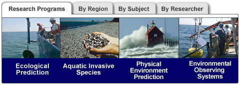
GLERL research is organized into four research programs: Ecological Prediction, Aquatic Invasive Species, Physical Environmental Prediction, and Environmental Observing Systems.

NOAA 5 year Research Plan

  • Earth System Modeling
  • Observing Systems and Networks to Support Earth System Modeling
  • NOAA Observing Systems Research
  • The Role of Our Research Partners

+ download plan [pdf] (36,628 kb)

Featured GLERL Research

+ FY07 GLERL Science Achievements
Results oriented descriptions of projects that have made significant contributions towards NOAA's mission.

Lake Erie Modis satellite image International Field Years on Lake Erie (IFYLE)
NOAA GLERL is leading a large scale collaborative research effort on Lake Erie. The project, the International Field Years on Lake Erie (IFYLE), began in May 2005, with a focus on hypoxia and harmful algal blooms.
+ Read more
+ View Lake Erie Physical Data Sets
Image of Buoy

Real-time Environmental Coastal Observations Network (RECON) Project
This project brings together a team of NOAA and Great Lakes institutes to construct experimental, integrated environmental observing systems. The integrated environmental observatory provide real-time observations of chemical, biological, and physical parameters.
+ Read more
+ View Real-time Data

Meteorological Station

Real-time Meteorological Observation Network
GLERL established and maintains a GLERL established and maintains a network of real-time meteorological stations at exposed coastal sites around southern Lake Michigan (Chicago, Milwaukee, Kenosha, South Haven and Michigan City) for the purposes of analyzing the impact of the meteorological data obtained by this network on nowcasts and forecasts of waves and circulation in the Great Lakes Coastal Forecasting System.
+ Read more
+ View Real-time Data

Collection of sediment from NOBOB vessel

No Ballast On Board Vessels (NOBOBs) as Vectors for Nonindigenous Species Introductions to the Great Lakes
The ballasting operations of NOBOB vessels present a previously overlooked risk as a possible vector for invasions via residual ballast material, but the magnitude of risk remains unresolved.
+ Read more

Basin diagram

Next Generation Large Basin Runoff Model
A fast, accurate model of weekly or monthly runoff volumes (with a daily internal computation interval) with relatively simple data requirements.
+ Read more
+ Download page


GLERL Research Centers

NOAA Center of Excellence for Great Lakes and Human Health
+ Read more

National Center for Research on Aquatic Invasive Species
+ Read more

Featured Data Products

Great Lakes Ice Atlas
An Electronic Atlas of Great Lakes Ice Cover Winters: 1973 - 2002
+ Read more

Water Levels
Great Lakes daily water level plots compared with last years levels; monthly minimum, maximum, and mean levels.
+ Read more

EcoNtwrk Software
+ Read more

Great Lakes Aquatic Nonindigenous Species List
+ Read more

Information Sheets

GLERL creates 1-2 page descriptions of a number of our current research projects and results. Written in plain-language and loaded with color and graphics.
+ View complete list

Water Levels in the Great Lakes Information Sheet

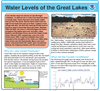
Water Levels in the Great Lakes (PDF)

Waterborne Contaminants in the Great Lakes (PDF)

Photo Gallery

GLERL Fieldwork image

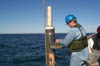
Fieldwork Photos of GLERL scientists at work in the field and in the laboratory showing sample collection techniques and sampling equipment.

+ View Fieldwork Photo Gallery

+ View Other GLERL Photo Galleries