![[NCEP Logo]](https://webarchive.library.unt.edu/eot2008/20080916174228im_/http://www.nhc.noaa.gov/graphics/ncep.gif)
Text-only version
(printer friendly)
TROPICAL CYCLONE REPORTS
Tropical Storm Allison
Tropical Depression Two
Tropical Storm Barry
Tropical Storm Chantal
Tropical Storm Dean
Hurricane Erin
Hurricane Felix
Hurricane Gabrielle
Tropical Depression Nine
Hurricane Humberto
Hurricane Iris
Tropical Storm Jerry
Hurricane Karen
Tropical Storm Lorenzo
Hurricane Michelle
Hurricane Noel
Hurricane Olga
|
Tropical Cyclone Report
Tropical Storm Dean
22 - 28 August 2001
Lixion A. Avila
National Hurricane Center
3 October 2001
Dean developed over the Virgin Islands and produced heavy rains
in Puerto Rico.
a. Synoptic History
Dean formed from a large tropical wave that crossed Dakar with
minimal shower activity between 14 and 15 August. It moved westward
and gradually began to develop thunderstorms. By the time the wave
was near 58 to 59 W, there was enough organization on satellite
imagery to dispatch a reconnaissance plane to the area. Reports
from the plane indicated that the wave had a large amplitude and
strong winds, but no closed circulation. At 1200 UTC 22 August, as
the wave was moving over the northern Leeward Islands at 15 to 20
knots, it developed a surface center. The center was observed on
satellite imagery as well as on San Juan radar. This was later
confirmed by a reconnaissance plane and surface observations.
Figure 1 is a radar image of Dean when it was located to the
northeast of Puerto Rico. By the time the system developed a
surface circulation, it already had tropical storm force winds,
northeast of the 1009 mb center. This transition is not uncommon to
occur with strong, fast-moving tropical waves. It is estimated that
Dean formed at 1200 UTC 22 August and moved west-northwestward
through the U.S. Virgin Islands. During the next 24 hours, Dean
encountered a hostile shearing environment produced by an
upper-level trough, causing the low-level center to move away from
the convection. A reconnaissance mission on the 23rd was
not able to find a closed circulation and Dean became a tropical
wave by 1500 UTC.
Dean's remnants moved rapidly to the north and became embedded
within a large middle-level trough just east of the U.S. A
reconnaissance flight on the 24th found a broad area of
low pressure and a few squalls. The low appeared to have some
non-tropical characteristics since the strongest winds and
convection were removed from the minimum pressure area. On the
25th, the low moved very little and convection began to
develop near the center of circulation. By 1800 UTC on the 26th,
there was enough thunderstorm activity to re-classify the system as
a tropical depression and it is estimated that it reached tropical
storm status by 0000 UTC on the 27th. Dean continued to strengthen
and reached its peak intensity of 60 knots and a minimum pressure
of 994 mb at 1800 UTC 27 August. Thereafter, Dean moved over cooler
waters and became an extratropical cyclone by 1800 UTC on 28
August. It was absorbed by a frontal low north of 50 N on the
29th.
b. Meteorological Statistics
Table 1 gives the "best track" positions and intensities of Dean
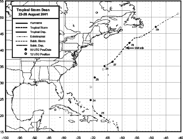
at six-hourly intervals. Figure 2 shows a plot of this track.
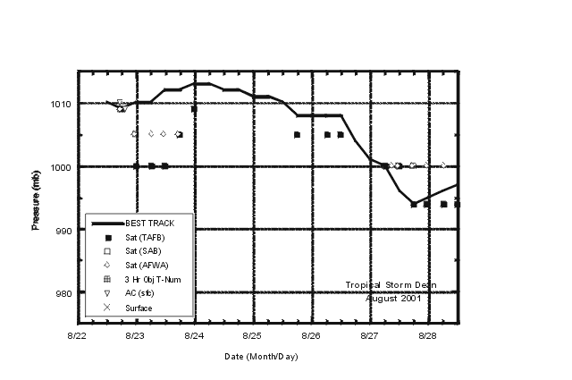
Figure 3 and Figure 4
depict the curves of maximum one-minute average
(10 m above sea-level) wind speed and minimum sea-level pressure,
respectively, as functions of time. Also plotted are the
observations on which the curves are based. These consist of ship
observations, data from reconnaissance flights as well as
satellite-based Dvorak-technique estimates using satellite imagery
by the Tropical Analysis and Forecast Branch (TAFB), Analysis
Branch (SAB), and the U.S. Air Force Weather Agency (AFWA). The
strongest wind reported from the reconnaissance plane was 65 knots
at the 1500-foot level, well to the northeast of the 1009 mb
poorly-defined center, and away from the Leeward Islands.
Juliana Airport at Saint Maarten reported gusts to 35 knots at
1000 UTC on the 22nd. St Thomas reported 35-knot winds with peak
gusts to 42 knots at 1818 UTC. St Croix reported gusts to 41 knots
at 1731 UTC on the same day. Craig D. Karnits, a private observer
in St Croix reported several peak gusts to 63 knots with a Texas
Weather Instrument WRL32 anemometer. However, the instrument is
located on a 300-foot hill. A report of 55 knots and 1004 mb
pressure from the vessel WGMJ was used to reinitiate advisories on
Dean. Heaviest rainfall occurred in Puerto Rico. Additional ship
data and surface observations are included in Table 2 and
Table 3.
c. Casualty and Damage Statistics
No reports of casualties associated with Dean have been
received. However, there were reports of damage caused by heavy
rains in Puerto Rico. Widespread flooding along the eastern and
southern sections of the island caused two bridges to collapse. A
large number of highways were inundated. There were 1320 homes
flooded. Preliminary reports indicate that the agricultural damage
is about $2 million. There were power outages, small trees blown
down and some roads damaged in the US Virgin Islands.
d. Forecast and Warning Critique
The track errors for the 12 hour forecasts (6 cases) averaged 46
n mi and for 24 hour (2 cases) the average was 72 n mi. The past
10-yr average official track errors for 12 and 24 hours are 44 and
82 n mi respectively. The tropical weather outlooks correctly
anticipated both the initial formation and the later redevelopment
of Dean. The U.S Virgin Islands briefly reported tropical storm
conditions and the possibility of strong gusty winds and rains was
indicated in the routine statements issued by the National
Hurricane Center. However, because Dean formed over or near the
U.S. Virgin Islands, there were no watches or warnings. This
situation might require a mechanism to be able to issue a watch or
warning prior to cyclogenesis. The government of the Bahamas issued
a tropical storm warning for the Southeastern Bahamas and for the
Turks and Caicos Islands and a tropical storm watch for the Central
Bahamas at 1800 UTC 22 August. Warnings and watches were
discontinued at 1500 UTC 23 August when Dean weakened to a tropical
wave. The northward turn of the system, away from the continental
United States was also always emphasized in the advisories and
tropical weather outlooks.
Table 1: Best track for Tropical Storm Dean, 22 - 28 August 2001.
Date/Time
(UTC) | Position | Pressure
(mb) | Wind Speed
(kt) | Stage |
| Lat. (°N) | Lon. (°W) |
| 22 / 1200 | 17.9 | 64.3 | 1010 | 45 | tropical storm |
| 22 / 1800 | 19.1 | 65.9 | 1009 | 50 | " |
| 23 / 0000 | 19.8 | 67.4 | 1010 | 50 | " |
| 23 / 0600 | 20.7 | 68.9 | 1010 | 50 | " |
| 23 / 1200 | 21.6 | 69.8 | 1012 | 30 | tropical depression
|
| 23 / 1800 | 23.0 | 70.2 | 1012 | 25 | tropical wave |
| 24 / 0000 | 24.6 | 70.8 | 1013 | 25 | low |
| 24 / 0600 | 26.6 | 70.7 | 1013 | 25 | " |
| 24 / 1200 | 28.6 | 70.7 | 1012 | 25 | " |
| 24 / 1800 | 30.3 | 70.2 | 1012 | 25 | " |
| 25 / 0000 | 31.5 | 69.4 | 1011 | 25 | " |
| 25 / 0600 | 32.7 | 67.9 | 1011 | 25 | " |
| 25 / 1200 | 34.0 | 66.5 | 1010 | 25 | " |
| 25 / 1800 | 35.0 | 66.0 | 1008 | 25 | " |
| 26 / 0000 | 35.0 | 66.0 | 1008 | 25 | " |
| 26 / 0600 | 35.0 | 66.0 | 1008 | 25 | " |
| 26 / 1200 | 35.2 | 65.5 | 1008 | 25 | " |
| 26 / 1800 | 35.5 | 65.0 | 1004 | 30 | tropical depression
|
| 27 / 0000 | 36.3 | 63.3 | 1001 | 40 | tropical storm |
| 27 / 0600 | 37.7 | 62.0 | 1000 | 50 | " |
| 27 / 1200 | 38.9 | 60.7 | 996 | 55 | " |
| 27 / 1800 | 40.6 | 59.4 | 994 | 60 | " |
| 28 / 0000 | 42.1 | 57.5 | 995 | 60 | " |
| 28 / 0600 | 43.5 | 56.0 | 996 | 55 | " |
| 28 / 1200 | 44.0 | 53.4 | 997 | 50 | " |
| 28 / 1800 | 45.5 | 50.5 | 998 | 45 | extratropical |
| 29 / 0000 | 47.0 | 48.5 | 999 | 45 | " |
| 29 / 0600 | 49.0 | 45.0 | 999 | 45 | " |
| 29 / 1200 | 51.0 | 40.9 | 1000 | 40 | " |
| 29 / 1800 | | | | | Absorbed by ext. low |
| 27 / 1800 | 40.6 | 59.4 | 994 | 60 | minimum pressure |
Table 2: Selected ship observations of tropical storm or greater
winds associated with Tropical Storm Dean, 22 - 28 August 2001.
| Ship Name or Call Sign | Date/Time (UTC) | Lat. (°N) | Lon. (°W) | Wind dir/speed (deg/kt) | Pressure (mb) |
| KRPP | 22 / 1100 | 18.8 | 62.8 | 110 / 37 | 1016.0 |
| WGMJ | 27 / 0600 | 37.8 | 61.6 | 190 / 55 | 1004.0 |
| JPPT | 27 / 1200 | 40.5 | 58.1 | 150 / 36 | 1014.0 |
| JPPT | 27 / 1800 | 41.0 | 55.9 | 170 / 47 | 1012.5 |
| MZIF7 | 28 / 0000 | 40.8 | 53.3 | 170 / 36 | 1017.2 |
| JPPT | 28 / 0000 | 41.1 | 53.6 | 160 / 42 | 1015.0 |
|
Table 3: Tropical Storm Dean selected surface observations, 22 - 28 August 2001.
| | Minimum
Sea-level
Pressure | Maximum Surface Wind Speed
(kt) | |
| Location | Date/
Time
(UTC) | Press.
(mb) | Date/
Timea
(UTC) | Sust.
Windb
(kts) | Peak
Gust (kts) | Storm
Surgec
(ft) | Storm
Tided
(ft) | Rain
(storm total)
(in) |
| Virgin Islands |
| St. Thomas | 22/190 | 1014.9 | 22/181 | 35 | 42 | | | 1.07 |
| St. Croix | 22/115 | 1014.6 | 22/172 | 28 | 41 | | | 0.49 |
| Maria Hill (300 ft) | | | 22/171 | 49 | 62 | | | |
| Puerto Rico |
| Central Aquirre Salinas | | | | | | | | 12.70 |
| San Lorenzo | | | | | | | | 9.78 |
| Ponce 4E | | | | | | | | 8.99 |
| River Cerrillos in Ponce | | | | | | | | 8.25 |
| Coamo | | | | | | | | 8.00 |
| Pico Del Este Luquillo | | | | | | | | 7.81 |
| Guayama | | | | | | | | 7.64 |
| Naguabo | | | | | | | | 7.61 |
| Luquillo | | | | | | | | 7.59 |
| Juana Diaz | | | | | | | | 7.31 |
| Vieques Camp Garcia | | | | | | | | 7.08 |
| Patillas | | | | | | | | 6.67 |
| Gurabo Upper-Alert | | | | | | | | 6.54 |
| Maunabo | | | | | | | | 6.24 |
| Las Piedras | | | | | | | | 5.86 |
| Aibonito | | | | | | | | 5.60 |
| Fajardo | | | | | | | | 4.81 |
| Barranquitas | | | | | | | | 4.61 |
| Ceiba | | | | | | | | 3.45 |
| Dorado | | | | | | | | 3.28 |
|

Figure 1:
A radar image of Dean when it was located to the
northeast of Puerto Rico.

Figure 2:
Best track positions for Tropical Storm Dean, 22-28 August 2001

Figure 3:
Best track maximum sustained surface wind
speed curve for Tropical Storm Dean, 22-28 August 2001, and the
observations on which the best track curve is based. Aircraft
observations have been adjusted for elevation using 85% reduction
factor for observations from 1500 ft.

Figure 4:
Best track minimum central pressure curve
for Tropical Storm Dean, 22-28 August, 2001.
|