![[NCEP Logo]](https://webarchive.library.unt.edu/eot2008/20080916171948im_/http://www.nhc.noaa.gov/graphics/ncep.gif)
Text-only version
(printer friendly)
TROPICAL CYCLONE REPORTS
Tropical Storm Allison
Tropical Depression Two
Tropical Storm Barry
Tropical Storm Chantal
Tropical Storm Dean
Hurricane Erin
Hurricane Felix
Hurricane Gabrielle
Tropical Depression Nine
Hurricane Humberto
Hurricane Iris
Tropical Storm Jerry
Hurricane Karen
Tropical Storm Lorenzo
Hurricane Michelle
Hurricane Noel
Hurricane Olga
|
Tropical Cyclone Report
Tropical Storm Chantal
14 - 22 August 2001
James L. Franklin
National Hurricane Center
6 September 2001
Revised: 15 November 2001
Poorly-organized for most of its life cycle, Chantal was a
tropical storm that made landfall near the Mexico-Belize border.
Development was hindered by a strong low- to mid-level easterly
flow that contributed to a rapid translation speed and persistent
westerly shear.
a. Synoptic History
Chantal developed from a tropical wave that crossed the coast of
Africa and entered the far eastern Atlantic on 11 August. Although
convection diminished after the system left the African continent,
a broad surface low and a closed circulation developed by the
13th. Early on the 14th, convection increased
northwest of the center. By 1800 UTC on the 14th, when
the system was about 1300 n mi east of the southern Windward
Islands, the convection was sufficiently well-established and
organized to consider the low to be a tropical depression. A
QuikSCAT pass near this time (at 2000 UTC), indicated a broad
closed cyclonic surface circulation.
The "best track" chart of Chantal's path is given in Figure 1,
with the wind and pressure histories shown in
Figure 2 and Figure 3,
respectively. The best track positions and intensities are listed
in Table 1. South of a strong mid-level ridge, the depression moved
rapidly westward at about 23 kt. The convective structure changed
little for the next 36 hours under easterly wind shear, but banding
developed early on the 16th. Even though the satellite
presentation continued to improve throughout the day,
reconnaissance aircraft data near 2100 UTC could not define a
closed circulation. It is impossible to determine precisely when
the depression's surface circulation degenerated into an open wave,
but a QuikSCAT pass suggests that this may have occurred near 1200
UTC on the 16th, when the consensus of Dvorak intensity
estimates reached tropical storm strength. At this time the
system's forward speed was increasing to near 30 kt.
Early on the 17th, the wave sped through the Windward
Islands, where there was a report of sustained tropical storm force
winds from Martinique. After passing through the islands, the
wave's speed slowed to about 20 kt and its convective pattern,
which had been limited and linear, expanded and became more
symmetric. At 1400 UTC, a reconnaissance aircraft was able to
determine that a small closed circulation had redeveloped about 250
n mi south of St. Croix; with winds still near 35 kt, the wave had
become a tropical storm.
Over the next 18 h the pressure fell from 1010 mb to 1003 mb and
Chantal's maximum winds increased to 55 kt. During the morning of
the 18th, however, Chantal weakened slightly as its
forward speed increased again (to 24 kt) and its low-level center
raced ahead of the deep convection. This was followed by a second
episode of slowing and strengthening that ended at 0600 UTC on the
19th, when the pressure fell to 997 mb and the winds
increased to 60 kt. At this time Chantal was moving westward at 12
kt about 160 n mi south of Kingston, Jamaica. It is possible that
the apparent reduction in forward speed was a result of a
reorganization or reformation of the low-level circulation.
During the day on the 19th, Chantal again became
disorganized with an ill-defined center located well to the
west-southwest of the main area of deep convection. Although the
pressure rose sharply, to 1008 mb, reconnaissance aircraft
continued to report strong winds in the trailing convection.
Chantal turned slightly to a west-northwesterly heading, and
maintained a near steady state structure in the northwestern
Caribbean Sea with 50 kt winds until late on the 20th.
(During this time, there were large differences, often 60 n mi or
more, between aircraft- and satellite-based position fixes. Since
the wind centers found by the aircraft were probably not
representative of the vorticity center of the system, the best
track through this period is based primarily on the satellite
data.)
When Chantal approached Belize and the Yucatan Peninsula late on
the 20th, the storm became much better organized.
Reconnaissance aircraft, which had for days had difficulty closing
off the circulation on the cyclone's south side, found a
well-defined center for the first time, with the strongest winds
closer to the center than was observed previously. Water vapor
imagery indicated that the upper-level westerly vertical wind shear
was decreasing, and the cyclone's forward speed again decreased,
from 15 to 10 kt. That these latter two events would occur
simultaneously suggests that a reduction in the low-level easterly
flow also contributed to this final period of development. The
pressure dropped steadily in the final hours before landfall,
reaching an estimated 999 mb when the center came ashore near the
Belize/Mexico border around 0200 UTC on the 21st. The
maximum winds at landfall are estimated to be 60 kt. As Chantal
made landfall its forward speed continued to slow, and radar
imagery from Belize showed that the system's organization continued
to improve for several hours as it slowly moved inland. Had Chantal
remained over water for another hour or two, it is quite likely
that it would have become a hurricane.
Over the next day and a half Chantal moved westward and then
southwestward over the Yucatan and southeastern Mexico, weakening
to a depression on the 22nd at 0000 UTC, and dissipating
by 1800 UTC that day.
b. Meteorological Statistics
Observations in Chantal (Figure 2 and Figure 3)
include satellite-based
Dvorak technique intensity estimates from the Tropical Analysis and
Forecast Branch (TAFB), the Satellite Analysis Branch (SAB) and the
U. S. Air Force Weather Agency (AFWA), as well as flight-level and
dropwindsonde observations from flights of the 53rd
Weather Reconnaissance Squadron of the U. S. Air Force Reserve
Command. Dropwindsonde data just prior to landfall were also
obtained from a NOAA Office of Marine and Aviation Operations WP-3D
research flight of the NOAA Hurricane Research Division.
Chantal's maximum intensity of 60 kt was attained on two
occasions. In the first instance, the peak flight-level wind from
reconnaissance aircraft in Chantal was 82 kt, measured at a flight
level of 850 mb at 1123 UTC on the 19th. While the
standard reduction for this altitude would indicate that Chantal
was a hurricane with a surface equivalent of 66 kt, several factors
suggest that this was not the case. First, the area of flight-level
winds that supported hurricane intensity were extremely limited,
and therefore may not have been representative of the cyclone's
circulation. Second, Chantal's minimum pressure was rising rapidly
at the time of the observation; this is consistent with the view
that the peak wind observed by the aircraft was primarily a local
convective, rather than a cyclone-scale event. The most convincing
evidence, however, comes from soundings in the storm core and
environment in the right semicircle, which show significant shear
in the lower troposphere. The Kingston sounding from 1200 UTC on
the 18th, for example, shows about 20 kt of easterly
shear between 925 and 700 mb. A dropwindsonde at 2340 UTC 19
August, which reported 700 mb winds of 60 kt, had a surface wind of
only 38 kt. In this environment, a lower than normal surface wind
reduction would be appropriate on the right-hand side of the
cyclone.
Chantal also reached an intensity of 60 kt just prior to
landfall. This estimate is supported by a surface wind of 58 kt
from a GPS dropwindsonde, and a surface-adjusted flight-level wind
of 57 kt. Numerous dropsonde profiles from Air Force and NOAA
aircraft just before landfall indicate that the surface adjustment
factors had returned to more typical values. The estimated landfall
pressure of 999 mb is based largely on an extrapolation of the
deepening trend observed by reconnaissance aircraft up until the
last report at 2307 UTC on the 20th.
Ship reports of winds of tropical storm force associated with
Chantal are given in Table 2, and selected surface observations
from land stations are given in Table 3. In the Lesser Antilles,
the automated site on Martinique (78922, station elevation 33 m)
reported a 10-min sustained wind of 34 kt at 0600 UTC on the
17th. Based on aircraft and dropsonde reports, the
strongest winds at landfall in the western Caribbean were likely in
a band roughly 30-40 n mi north of the center, near Chinchorro
Banco. Unfortunately, there are no observing stations in this area.
Caye Caulker, Belize reported a gust of 62 kt, and Chetumal, Mexico
reported a gust of 54 kt.
Chantal produced copious amounts of rain (Table 3). The largest
storm total (13.41 in) was reported from Chetumal. Several sites in
Belize reported totals in the 8-10 in range.
c. Casualty and Damage Statistics
There are no deaths officially associated with Chantal while it
was a tropical cyclone. However, two deaths were reported in
Trinidad on the 16th from lightning associated with the
passage of the tropical wave through the Lesser Antilles.
In Belize, damage estimates are near $4 million, primarily from
wave damage to sea-walls and piers, agricultural losses from wind
and floods, and erosion of roads due to floods. About 8000 persons
were evacuated, mainly from offshore islands. About 2500 persons
were evacuated from vulnerable areas in Mexico. Reports from Mexico
indicate downed trees but otherwise no significant damage.
d. Forecast and Warning Critique
Average official track errors for Chantal were 44, 74, 84, 106,
and 135 n mi for the 12, 24, 36, 48, and 72 h forecasts,
respectively (Table 4). The number of cases ranged from 16 at 12 h
to 6 at 72 h. These errors are lower than the average official
track errors for the 10-yr period 1991-2000 (44, 82, 118, 151, and
226 n mi, respectively). This is not surprising for a relatively
straight-moving storm in the deep tropics. A number of guidance
models had lower errors than the official forecast through 36 h,
including the GFDI and UKMI. None of the guidance models (other
than CLIPER) had errors lower than the official forecast at 72 h.
It should be noted that forecast errors during the tropical
depression stage, which are not part of the official verification,
were considerably higher.
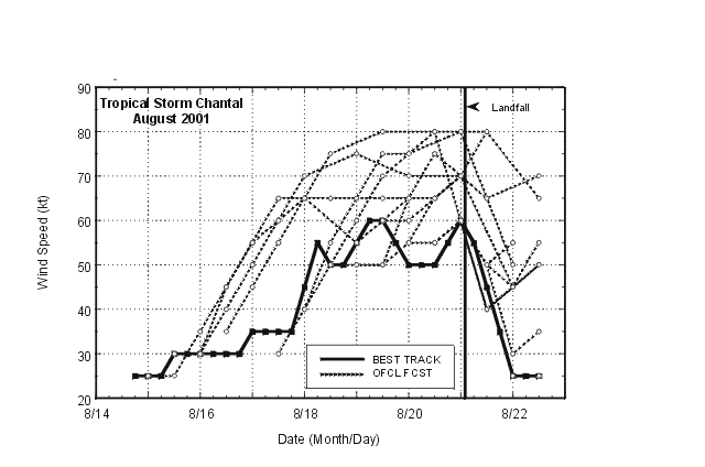
Average official track errors were close to those of the AVNI.
Of interest is a modest but persistent rightward bias in the
official forecasts (Figure 4). This was related to a reliance on the
AVNI, which has performed well so far this year. While the formal
AVNI verification for Chantal (Table 4) shows good results, this is
misleading. The AVN center-tracking algorithm frequently failed to
follow the cyclone for the duration of the forecast period (there
were only four 48 h AVNI forecasts and no 72 h AVNI forecasts).
Nonetheless, a low-level vorticity center was easily followed in
the AVN fields, and this influenced the official forecasts. While
the AVN repeatedly took the vorticity center into the eastern Gulf
of Mexico, none of these poor forecasts are officially verified
because the tracker did not recognize the vorticity center as the
tropical cyclone.
Average official intensity errors were 6, 8, 12, 23, and 23 kt
for the 12, 24, 36, 48, and 72 h forecasts, respectively. For
comparison, the average official intensity errors over the 10-yr
period 1991-2000 are 7, 11, 14, 16, and 20 kt, and the SHIPS model
for Chantal had errors of 8, 9, 10, 16, and 16 kt, respectively.
While the shorter-range forecasts for Chantal were more accurate
than the official long-term averages and the SHIPS guidance, the 48
and 72 h forecasts were not. Inspection shows that every 36, 48,
and 72 official intensity forecast was an overestimate (Fig. 5).
Two factors may have contributed to these overly-aggressive
forecasts: reliance on global model predictions of a developing
anticyclone over Chantal, and, in the western Caribbean Sea, an
atypical vertical shear distribution that forced the low-level
circulation center to repeatedly move out ahead of the main
convection.
Table 5 lists the watches and warnings associated with Chantal.
Although Chantal was not a tropical storm when it moved through the
Lesser Antilles, the remnant wave did produce some tropical storm
force winds. Since the system was not a tropical cyclone at that
time, no warnings were in effect during the passage. Had a
mechanism existed to issue tropical storm warnings in the absence
of a tropical cyclone, it would have been possible to maintain
warnings for tropical storm force winds.
Official track forecasts anticipated a close approach to Jamaica
and the Cayman Islands, which resulted in warnings that did not
verify. Chantal made landfall near the Mexico/Belize border,
roughly in the center of the warning area. A tropical storm warning
was issued for a portion of the Gulf coast of Mexico in
anticipation of Chantal's re-emergence over water into the Gulf.
However, Chantal remained over land.
Table 1: Table 1. Best track for Tropical Storm Chantal, 14-22 Aug. 2001.
Positions and pressures given during the tropical wave stage are
representative values for the low-level vorticity center.
Date/Time
(UTC) | Position | Pressure
(mb) | Wind Speed
(kt) | Stage |
| Lat. (°N) | Lon. (°W) |
| 14 / 1800 | 12.8 | 37.0 | 1010 | 25 | tropical depression |
| 15 / 0000 | 12.9 | 39.3 | 1010 | 25 | " |
| 15 / 0600 | 12.6 | 41.6 | 1010 | 25 | " |
| 15 / 1200 | 12.3 | 43.9 | 1010 | 30 | " |
| 15 / 1800 | 12.3 | 46.3 | 1010 | 30 | " |
| 16 / 0000 | 12.4 | 48.8 | 1010 | 30 | " |
| 16 / 0600 | 12.4 | 51.3 | 1011 | 30 | " |
| 16 / 1200 | 12.7 | 53.9 | 1012 | 30 | tropical wave |
| 16 / 1800 | 12.7 | 57.2 | 1012 | 30 | " |
| 17 / 0000 | 13.1 | 60.6 | 1011 | 35 | " |
| 17 / 0600 | 13.3 | 62.8 | 1011 | 35 | " |
| 17 / 1200 | 13.7 | 64.6 | 1010 | 35 | tropical storm |
| 17 / 1800 | 14.2 | 66.4 | 1006 | 35 | " |
| 18 / 0000 | 14.4 | 68.2 | 1004 | 45 | " |
| 18 / 0600 | 14.6 | 70.4 | 1003 | 55 | " |
| 18 / 1200 | 14.8 | 72.9 | 1006 | 50 | " |
| 18 / 1800 | 15.3 | 75.2 | 1003 | 50 | " |
| 19 / 0000 | 15.3 | 77.2 | 1002 | 55 | " |
| 19 / 0600 | 15.4 | 78.4 | 997 | 60 | " |
| 19 / 1200 | 15.7 | 79.6 | 1004 | 60 | " |
| 19 / 1800 | 16.2 | 81.1 | 1005 | 55 | " |
| 20 / 0000 | 16.7 | 82.6 | 1007 | 50 | " |
| 20 / 0600 | 17.1 | 84.1 | 1008 | 50 | " |
| 20 / 1200 | 17.5 | 85.6 | 1007 | 50 | " |
| 20 / 1800 | 17.9 | 86.7 | 1006 | 55 | " |
| 21 / 0000 | 18.1 | 87.7 | 1000 | 60 | " |
| 21 / 0600 | 18.2 | 88.1 | 1000 | 55 | " |
| 21 / 1200 | 18.4 | 88.7 | 1002 | 45 | " |
| 21 / 1800 | 18.6 | 89.5 | 1006 | 35 | " |
| 22 / 0000 | 18.7 | 90.3 | 1007 | 25 | tropical depression |
| 22 / 0600 | 18.4 | 91.2 | 1008 | 25 | " |
| 22 / 1200 | 17.9 | 92.2 | 1009 | 25 | " |
| 22 / 1800 | | | | | dissipated |
| 21 / 0200 | 18.1 | 87.8 | 999 | 60 | landfall near Mexico/Belize border |
| 19 / 0600 | 15.4 | 78.4 | 997 | 60 | minimum pressure |
Table 2: Selected ship observations of tropical storm or greater
winds associated with Tropical Storm Chantal, 14 - 22 August 2001.
| Ship Name or Call Sign | Date/Time (UTC) | Lat. (°N) | Lon. (°W) | Wind dir/speed (deg/kt) | Pressure (mb) |
| C6LF8 | 18 / 1200 | 16.4 | 71.4 | 090/37 | 1011.5 |
| C6RO7 | 18 / 1200 | 16.3 | 71.1 | 110/37 | 1012.0 |
| C6RO7 | 18 / 1500 | 15.7 | 70.9 | 100/38 | 1012.8 |
|
Table 3: Tropical Storm Chantal selected surface observations, 14 - 22 August 2001.
| | Minimum
Sea-level
Pressure | Maximum Surface Wind Speed
(kt) | |
| Location | Date/
Time
(UTC) | Press.
(mb) | Date/
Timea
(UTC) | Sust.
Windb
(kts) | Peak
Gust (kts) | Storm
Surgec
(ft) | Storm
Tided
(ft) | Rain
(storm total)
(in) |
| Lesser Antilles |
| Martinique-Caravelle | | | 17/060 | 34e | 41 | | | |
| Martinique-Vauclin | | | 17/040 | | 49 | | | |
| Belize |
| Towerhill | | | | | | | | 9.81 |
| Libertad | 21/090 | 1001.5 | | | | | | 9.08 |
| Consejo | | | | | | | | 8.99 |
| Belize City Intl. Airpt. | 21/050 | 1007.0 | 21/050 | 19 | 35 | | | 8.24 |
| Middlesex | | | | | | | | 7.93 |
| Melinda | | | | | | | | 7.06 |
| Gales Point | | | | | | | | 6.80 |
| Bigfalls Plantation | | | | | | | | 5.20 |
| Half Moon Caye | 20/210 | 1007.1 | | | | | | |
| Caye Caulker | 21/020 | 1005.8 | 21/010 | | 62 | | | |
| Mexico |
| Chetumal Tecnologico | | | | | | | | 13.41 |
| Chetumal Observatorio | 21/080 | 1005.4 | 21/070 | | 54 | | | 13.05 |
| Chetumal (Air Force) | 21/100 | 1008.0 | 21/100 | 35 | 45 | | | |
| Nicolas Bravo | | | | | | | | 11.28 |
| La Union | | | | | | | | 5.59 |
| Cancun | | | | | | | | 1.68 |
e10-min average. |
Table 4: Preliminary track forecast evaluation for Tropical Storm Chantal - heterogeneous sample. Errors in nautical miles for
tropical storm and hurricane stages with number of forecasts in
parentheses. Bold numbers represent forecasts which were
better than the official forecast.
| Forecast Technique | Period (hours) |
| 12 | 24 | 36 | 48 | 72 |
| CLIP | 43 (16) | 81 (14) | 97 (12) | 92 (10) | 125 (6) |
| GFDI | 35 (13) | 56 (13) | 67 (11) | 77 (9) | 176 (5) |
| LBAR | 43 (16) | 79 (14) | 107 (12) | 137 (10) | 214 (6) |
| AVNI | 44 (10) | 70 (10) | 97 (8) | 105 (4) | |
| BAMD | 45 (16) | 77 (14) | 119 (12) | 171 (10) | 298 (6) |
| BAMM | 43 (16) | 60 (14) | 83 (12) | 111 (10) | 161 (6) |
| BAMS | 68 (16) | 108 (14) | 146 (12) | 170 (10) | 195 (6) |
| NGPI | 75 (5) | 89 (5) | 104 (5) | 150 (5) | 242 (4) |
| UKMI | 43 (14) | 55 (12) | 79 (11) | 117 (9) | 182 (2) |
| GUNS | 57 (4) | 65 (4) | 62 (4) | 100 (4) | 164 (3) |
| NHC Official | 44 (16) | 74 (14) | 84 (12) | 106 (10) | 135 (6) |
| NHC Official (1991-2000 mean) | 44 (2049) | 82 (1835) | 118 (1646) | 151 (1475) | 226 (1187) |
| *Output from these models was unavailable at time of forecast issuance. |
Table 5: Watch and warning summary, Tropical Storm Chantal, 14 - 22 August 2001.
| Date/Time | Action | Location |
| 16/0300 | Tropical Storm Watch issued | Barbados, St.Vincent, and St.Lucia |
| 16/0900 | Tropical Storm Watch changed to Tropical Storm
Warning | Barbados, St.Vincent, and St.Lucia |
| 16/0900 | Tropical Storm Watch | Grenadines and Dominica |
| 16/1200 | Tropical Storm Watch | Martinique |
| 16/1500 | Tropical Storm Watch changed to Tropical Storm
Warning | Grenadines and Dominica |
| 16/1500 | Tropical Storm Watch issued | Grenada and Tobago |
| 16/1600 | Tropical Storm Watch issued | Guadeloupe |
| 17/0000 | Tropical Storm Watches/Warnings
discontinued | Barbados, St.Vincent, St.Lucia, Grenadines,
Dominica, Grenada and Tobago |
| 17/1200 | Tropical Storm Watch discontinued | Martinique and Guadeloupe |
| 17/2100 | Hurricane Watch issued | Jamaica |
| 18/0000 | Tropical Storm Watch issued | Cayman Is. |
| 18/0900 | Hurricane Warning replaces Hurricane Watch | Jamaica |
| 18/1500 | Tropical Storm Warning/Hurricane Watch replace
Hurricane Warning | Jamaica |
| 18/1500 | Tropical Storm Warning/Hurricane Watch replace
Tropical Storm Watch | Cayman Is. |
| 19/0000 | Tropical Storm Watch issued | Belize |
| 19/0300 | Tropical Storm Watch issued | Chetumal to Cancun, Mexico |
| 19/0900 | Hurricane Watch discontinued | Jamaica |
| 19/1500 | Hurricane Watch replaces Tropical Storm
Watch | Belize City, Belize to Cancun, Mexico |
| 19/1500 | Tropical Storm Warning discontinued | Jamaica |
| 20/0000 | Hurricane Watch discontinued | Cayman Is. |
| 20/0300 | Tropical Storm Warning issued | Belize |
| 20/0300 | Tropical Storm Warning issued | Chetumal to Cancun, Mexico |
| 20/1200 | Tropical Storm Warning discontinued | Cayman Is. |
| 20/2100 | Tropical Storm Warning issued | Progreso to Carmen, Mexico |
| 21/1500 | Hurricane Watch discontinued | Belize |
| 21/1500 | Hurricane Watch discontinued | Chetumal to Cancun, Mexico |
| 21/2100 | Tropical Storm Warning discontinued | Belize |
| 21/2100 | Tropical Storm Warning discontinued | Chetumal to Cancun, and Campeche to Progreso, Mexico |
| 21/2100 | Tropical Storm Watch issued | Carmen to Veracruz, Mexico |
| 22/1500 | All watches/warnings discontinued | Campeche to Veracruz, Mexico |
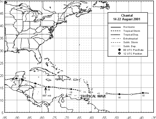
Figure 1:
Best track positions for Tropical Storm Chantal, 14-22 Aug. 2001.
Positions given by arrowheads during the tropical wave stage represent
the location of the low-level vorticity center.

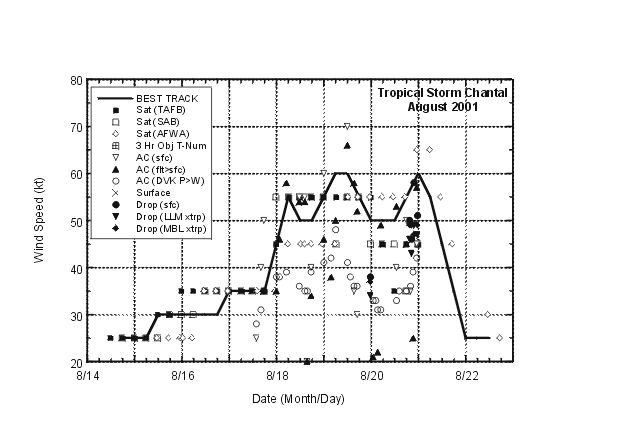
Figure 2:
Best track maximum sustained surface wind speed curve for Tropical Storm
Chantal, 14-22 Aug. 2001, and the observations on which the best track curve
is based. Aircraft observations have been adjusted for elevation using 90%,
80%, and 80% reduction factors for observations from 700 mb, 850 mb, and
1500 ft, respectively. Dropwindsonde observations include actual 10 m winds
(sfc), as well as surface estimates derived from the mean wind over the
lowest 150 m of the wind sounding (LLM), and from the sounding boundary
layer mean (MBL).Figure includes the period from 1200 UTC 16 August through
0600 UTC 17 August when Chantal was a tropical wave.

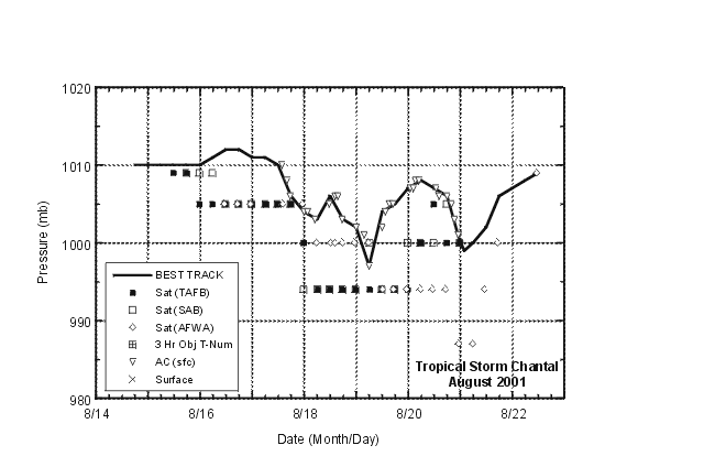
Figure 3:
Best track minimum central pressure curve
for Tropical Storm Chantal, 14-22 Aug. 2001, and the observations
on which the best track curve is based. Figure includes the period
from 1200 UTC 16 August through 0600 UTC 17 August when Chantal was
a tropical wave.
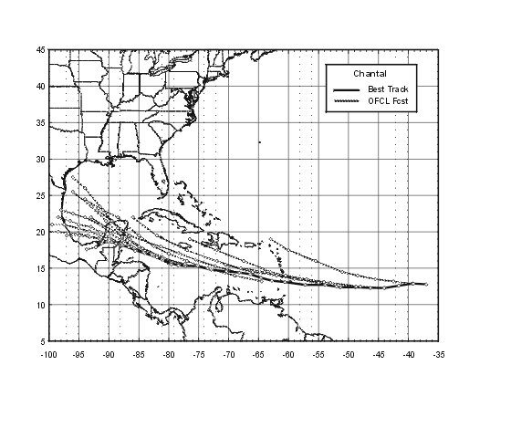
Figure 4:
Selected (0000 and 1200 UTC) official track
forecasts (dashed lines, with 0, 12, 24, 36 ,48, and 72 h positions
indicated) for Tropical Storm Chantal, 14-22 Aug. 2001. The best
track is given by the thick solid line with positions given at 6 h
intervals.

Figure 5:
Selected (0000 and 1200 UTC) official
intensity forecasts (dashed lines) for Tropical Storm Chantal,
14-22 Aug. 2001. The best track intensity is given by the thick
solid line.
|