Chesapeake Bay Flyover and Watershed Region
|
|
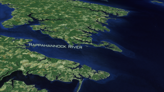
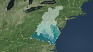
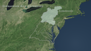
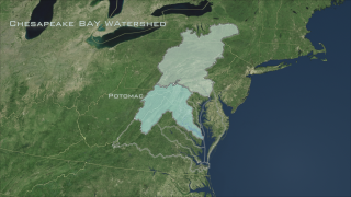
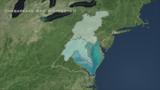
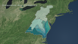
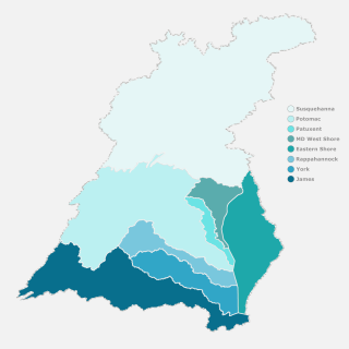
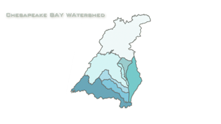
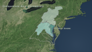
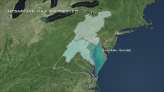
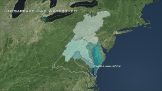
The watershed that drains into the Chesapeake Bay is a huge expanse that extends 64,000 miles into five states across North America (New York, Pensylvania, Maryland, Delaware, Virginia) and the District of Columbia. This visualization overlays the full watershed onto a Landsat satellite visualization of the Bay area. The eight different distinctly colored regions indicate the Chesapeake's major subwatersheds. These subwatershed regions are: Susquehanna, Potomac, Patuxent, MD West Shore, Rapahhannock, Eastern Shore, James and York. This visualization is an extension of the Chesapeake Bay Flyover (#3446) in order to demonstrate the entire Chesapeake Bay Watershed region. The imagery utilized for this animation is a false-color Chesapeake Bay Landsat-7 Mosaic (#3473) composed of eight scenes acquired between 1999-2002, which were put together and color corrected to resemble natural looking colors.
|
|
|
|
Chesapeake Bay Flyover and Watershed Region animation with city and river labels
Duration: 4.4 minutes
Available formats:
1280x720 (30 fps)
MPEG-4
205 MB
640x360 (30 fps)
MPEG-4
41 MB
512x288 (30 fps)
MPEG-1
79 MB
1280x720 (30 fps)
MPEG-2
557 MB
1280x720 (30 fps)
Frames (HDWatershedLabelsComposite30fp)
1280x720 (60 fps)
Frames (HDWatershedLabelsComposite)
1280x720
TIFF
3 MB
320x180
PNG
287 KB
How to play our movies
|
|
|
|
Chesapeake Bay Flyover and Watershed Region animation, without city and river labels
Duration: 4.4 minutes
Available formats:
1280x720 (30 fps)
MPEG-4
230 MB
640x360 (30 fps)
MPEG-4
41 MB
512x288 (30 fps)
MPEG-1
79 MB
1280x720 (30 fps)
MPEG-2
546 MB
1280x720 (30 fps)
Frames (HDWatershedComposite30fp)
1280x720 (60 fps)
Frames (HDWatershedComposite)
3840x2160
TIFF
10 MB
1280x720
TIFF
2 MB
320x180
PNG
282 KB
160x80
PNG
63 KB
80x40
PNG
16 KB
How to play our movies
|
|
|
|
This frame sequence contains the extended Chesapeake Bay Flyover without any statelines or the watershed overlay region
Available formats:
1280x720 (60 fps)
Frames (HDWatershedLand)
320x180
PNG
126 KB
How to play our movies
|
|
|
|
This frame sequence contains the US Statelines overlay only
Available formats:
1280x720 (60 fps)
Frames (HDStateLines)
320x180
PNG
23 KB
How to play our movies
|
|

|
|
This frame sequence contains the city and river text labels overlay
Available formats:
1280x720 (60 fps)
Frames (HDLabelsOverlay)
320x180
PNG
2 KB
How to play our movies
|
|

|
|
This frame sequence contains the river text labels overlay only
Available formats:
1280x720 (60 fps)
Frames (HDRiversOverlay)
320x180
PNG
2 KB
How to play our movies
|
|

|
|
This frame sequence contains the city text labels overlay only
Available formats:
1280x720 (60 fps)
Frames (HDCityOverlay)
320x180
PNG
3 KB
How to play our movies
|
|

|
|
This frame sequence contains the Chesapeake Bay Watershed with text labels describing the different regions
Available formats:
1280x720 (60 fps)
Frames (HDWatershedOverlay)
320x180
PNG
36 KB
How to play our movies
|
|
|
|
Susquehanna Watershed Region
Available formats:
1280 x 720
TIFF
2 MB
320 x 180
PNG
290 KB
|
|
|
|
Potomac Watershed Region
Available formats:
1280 x 720
TIFF
2 MB
320 x 180
PNG
290 KB
|
|

|
|
Patuxent Watershed Region
Available formats:
1280 x 720
TIFF
2 MB
320 x 180
PNG
281 KB
|
|

|
|
MD West Shore Watershed Region
Available formats:
1280 x 720
TIFF
2 MB
320 x 180
PNG
280 KB
|
|

|
|
Eastern Shore Watershed Region
Available formats:
1280 x 720
TIFF
2 MB
320 x 180
PNG
282 KB
|
|

|
|
Rappahannock Watershed Region
Available formats:
1280 x 720
TIFF
2 MB
320 x 180
PNG
281 KB
|
|
|
|
York Watershed Region
Available formats:
1280 x 720
TIFF
2 MB
320 x 180
PNG
280 KB
|
|
|
|
James Watershed Region
Available formats:
1280 x 720
TIFF
2 MB
320 x 180
PNG
279 KB
|
|
|
|
Image: Chesapeake Bay Watershed Regions
Latitude (min, max) = (36.32, 43.26)
Longitude (min, max) = (73.93, 80.87)
Available formats:
5000 x 5000
TIFF
1 MB
2500 x 2500
TIFF
876 KB
1500 x 1500
TIFF
424 KB
320 x 320
PNG
62 KB
|
|
This product is available through our Web Map Service.
Click here to learn more.
|
| Animation Number: | 3472 |
| Animators: | Helen-Nicole Kostis (SVS) (Lead) |
| | Cindy Starr (SVS) |
| | Jeff de La Beaujardiere (SVS) |
| | Greg Shirah (SVS) |
| Completed: | 2007-10-11 |
| Producer: | Andy Freeberg (NASA/GSFC) |
| Scientists: | Darrel Williams (NASA/GSFC) |
| | Laura Rocchio (SSAI) |
| Instrument: | Landsat-7/ETM+ |
| Data Collected: | The mosaic was created by EarthSat under contract with NASA as part of the GeoCover 2000 product. All images used in GeoCover were acquired by Landsat 7 during the period of 1999-2002. The pixel size of the full resolution image represents 14.25 m on the ground.
The Chesapeake Bay mosaic uses portions of eight Landsat-7 scenes. Below you will find a listing of the eight Landsat 7 images that were put together to create the composite image. Landsat scenes are organized by a Path and Row number according to the Worldwide Reference System. (To learn more about Landsat's Worldwide Reference System, please visit: http://landsat.gsfc.nasa.gov/about/wrs.html)
Scenes used in the Chesapeake Bay mosaic:
Landsat 7 WRS Path 15-Row 32 acquired on Oct. 05, 2001
Landsat 7 WRS Path 14-Row 32 acquired on Sept. 23, 1999
Landsat 7 WRS Path 15-Row 33 acquired on October 05, 2001
Landsat 7 WRS Path 14-Row 33 acquired on July 10, 2001
Landsat 7 WRS Path 15-Row 34 acquired on Sept. 30, 1999
Landsat 7 WRS Path 14-Row 34 acquired on July 10, 2001
Landsat 7 WRS Path 15-Row 35 acquired on Sept. 30, 1999
Landsat 7 WRS Path 14-Row 35 acquired on Sept. 23, 1999 |
| Series: | Landsat 7 |
| | Chesapeake Bay |
| Goddard TV Tapes: | G2008-034HD -- NASAs HD Chesapeake Bay Resource Tape |
| | G2008-041HD -- NASAs Landsat in HD 2008 Resource Tape |
Keywords:
SVS
>> Chesapeake Bay
SVS
>> Flyover
SVS
>> HDTV
SVS
>> Landsat
GCMD
>> EARTH SCIENCE
|
|
Please give credit for this item to
NASA/Goddard Space Flight Center Scientific Visualization Studio |
|
Back to Top
|

