Chesapeake Bay Flyover
|
|
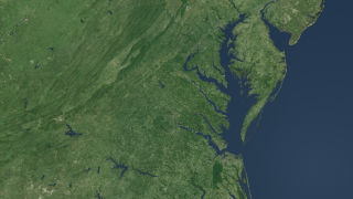
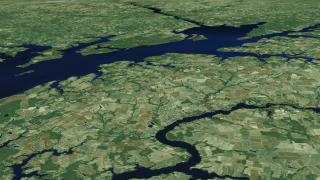
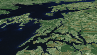
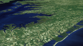
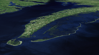
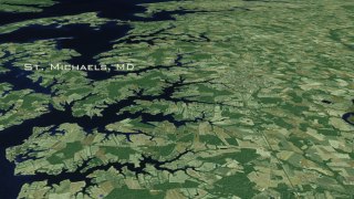
The Chesapeake Bay an area of approximately 200 miles is North America's largest estuary. The Bay and its tributaries comprises a complex ecosystem which encompasses rivers, wetlands, trees and habitats. This animation takes us on a tour around the Bay starting from its 'mouth' near Norfolk, Virginia, flying north up to the Susquehanna River and then flying down the area of the Eastern Shore all the way to the Fishermans Island, zooming out to get a look of the Chesapeake bay region. The imagery utilized for this animation is a false-color Chesapeake Bay Landsat-7 Mosaic (#3473) composed of eight scenes acquired between 1999-2002, which were put together and color corrected to resemble natural looking colors.
|
|
|
|
Chesapeake Bay flyover
Duration: 3.5 minutes
Available formats:
1280x720 (30 fps)
MPEG-4
171 MB
640x360 (30 fps)
MPEG-4
37 MB
512x288 (30 fps)
MPEG-1
69 MB
1280x720 (30 fps)
MPEG-2
435 MB
1280x720 (30 fps)
Frames (BayFlyover30fp)
1280x720 (60 fps)
Frames (BayFlyover)
3840x2160
TIFF
11 MB
1280x720
TIFF
2 MB
320x180
PNG
274 KB
160x80
PNG
64 KB
80x40
PNG
16 KB
How to play our movies
|
|

|
|
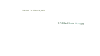
Chesapeake Bay Flyover with major cities and rivers text labels
Duration: 3.5 minutes
Available formats:
1280x720 (30 fps)
MPEG-4
170 MB
640x360 (30 fps)
MPEG-4
37 MB
512x288 (30 fps)
MPEG-1
69 MB
1280x720 (30 fps)
MPEG-2
435 MB
1280x720 (30 fps)
Frames (BayFlyoverLabels30fp)
1280x720 (60 fps)
Frames (BayFlyoverLabels)
1280x720
TIFF
2 MB
320x180
PNG
318 KB
How to play our movies
|
|
|
|
This frame sequence contains the city and river text labels overlay
Available formats:
1280x720 (60 fps)
Frames (LabelsOverlay)
320x180
PNG
2 KB
How to play our movies
|
|

|
|
This frame sequence contains the city text labels overlay only
Available formats:
1280x720 (60 fps)
Frames (CitiesLabelsOverlay)
320x180
PNG
3 KB
How to play our movies
|
|

|
|
This frame sequence contains the river text labels overlay only
Available formats:
1280x720 (60 fps)
Frames (RiversLabelsOverlay)
320x180
PNG
2 KB
How to play our movies
|
|

|
|
Overlooking the area of Norfolk and Hampton, Virginia
Available formats:
3840 x 2160
TIFF
10 MB
1280 x 720
TIFF
1 MB
320 x 180
PNG
301 KB
|
|
|
|
Flying above Treasure Island
Available formats:
3840 x 2160
TIFF
8 MB
1280 x 720
TIFF
1 MB
320 x 180
PNG
280 KB
|
|
|
|
Bay Bridge, Annapolis, Baltimore and islands in the surrounding area
Available formats:
3840 x 2160
TIFF
9 MB
1280 x 720
TIFF
1 MB
320 x 180
PNG
290 KB
|
|
|
|
The mouth of Susquehanna River
Available formats:
3840 x 2160
TIFF
10 MB
1280 x 720
TIFF
1 MB
320 x 180
PNG
309 KB
|
|
|
|
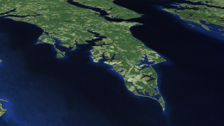
Islands of the Eastern Shore
Available formats:
3840 x 2160
TIFF
8 MB
1280 x 720
TIFF
1 MB
320 x 180
PNG
298 KB
|
|
|
|
Wetlands of the Eastern Shore
Available formats:
3840 x 2160
TIFF
11 MB
1280 x 720
TIFF
1 MB
320 x 180
PNG
303 KB
|
|
|
|
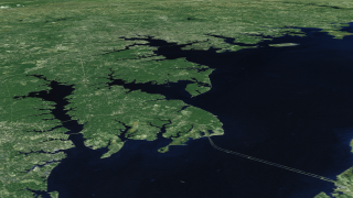
Wetlands of the Eastern shore and Fishermans Island
Available formats:
3840 x 2160
TIFF
8 MB
1280 x 720
TIFF
1 MB
320 x 180
PNG
277 KB
|
| Animation Number: | 3446 |
| Animators: | Helen-Nicole Kostis (Lead) |
| | Cindy Starr |
| Studio: | University of Maryland |
| Completed: | 2007-08-24 |
| Producer: | Andy Freeberg (NASA/GSFC) |
| Scientists: | Darrel Williams (NASA/GSFC) |
| | Laura Rocchio (SSAI) |
| Instrument: | Landsat-7/ETM+ |
| Data set: | ETM+ |
| Data Collected: | The mosaic was created by EarthSat under contract with NASA as part of the GeoCover 2000 product. All images used in GeoCover were acquired by Landsat 7 during the period of 1999-2002. The pixel size of the full resolution image represents 14.25 m on the ground.
The Chesapeake Bay mosaic uses portions of eight Landsat-7 scenes. Below you will find a listing of the eight Landsat 7 images that were put together to create the composite image. Landsat scenes are organized by a Path and Row number according to the Worldwide Reference System. (To learn more about Landsat's Worldwide Reference System, please visit: http://landsat.gsfc.nasa.gov/about/wrs.html)
Scenes used in the Chesapeake Bay mosaic:
Landsat 7 WRS Path 15-Row 32 acquired on Oct. 05, 2001
Landsat 7 WRS Path 14-Row 32 acquired on Sept. 23, 1999
Landsat 7 WRS Path 15-Row 33 acquired on October 05, 2001
Landsat 7 WRS Path 14-Row 33 acquired on July 10, 2001
Landsat 7 WRS Path 15-Row 34 acquired on Sept. 30, 1999
Landsat 7 WRS Path 14-Row 34 acquired on July 10, 2001
Landsat 7 WRS Path 15-Row 35 acquired on Sept. 30, 1999
Landsat 7 WRS Path 14-Row 35 acquired on Sept. 23, 1999 |
| Series: | Landsat 7 |
| | Chesapeake Bay |
| Goddard TV Tape: | G2008-034HD -- NASAs HD Chesapeake Bay Resource Tape |
Keywords:
SVS
>> Chesapeake Bay
SVS
>> Flyover
SVS
>> HDTV
SVS
>> Landsat
GCMD
>> EARTH SCIENCE
|
|
Please give credit for this item to
NASA/Goddard Space Flight Center Scientific Visualization Studio |
|
Back to Top
|

