|
Russian-American
Long-term Census of the Arctic (RUSALCA) Intro | Leg1 | Leg2 | Cruise Report | Station Log | Photos |
|
|
|
|
|
|
|
Vladivostok, Russia- Nome, USA
1Bordering the Bering Sea at its southern terminus with the Pacific Ocean is the Aleutian Volcanic Arc. Waters Entering and exiting the Bering Sea from and to the Pacific Ocean transit through this Arc and are most likely chemically and dynamically modified by their interaction with the intense hydrothermal activity emitted from the mid-water volcanoes. Quantifying the flux from this relatively shallow volcanic arc and its influence on the waters and atmosphere above are important factors when considering the relationship between earth processes, ocean and greenhouse gas exchanges. Russian Federation scientists have carried out exploration of this region in the past. However this was the first opportunity for scientists from both the U.S. and Russia to work together to map the volcanic features and search for fluxes of methane, mercury and other hydrothermal fluids and gases. During the first leg of the RUSALCA Expedition, we study the hydrothermal activity and related geological and biological processes associated with the Piips volcano, which lies at a depth of 500 m in the southern part of the Komandorskaya depression of the western Aleutian Arc. Russian marine geologists discovered the Piips hydrothermal field in 1987. Temperatures of up to 130 C were measured and hydrothermal deposits comprised of sulfates, carbonates, amorphous silica etc were discovered. In addition, large fields of bacterial mats and numerous hydrothermal fauna were detected. However, very little is known about the influence of hydrothermal activity on the regional bio-chemical, and physical environment of the neighboring ocean. During the RUSALCA expedition, the combined Russian side-looking sonar –CTD-methane sensors were lowered over the volcano. However upon retrieval after the second launch, the sonar was Two-blocked and lost at sea. Atmospheric monitoring of mercury along this leg from Vladivostok revealed high concentrations near the Asian coastline and again over the volcano. Because of its relatively shallow depth, the data suggest that mercury is released to the water column and atmosphere above as a result of vigorous hydrothermal activity at this site. http://oceanexplorer.noaa.gov/explorations/04arctic/welcome.html - top |
|
|

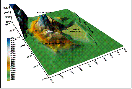 Bathymetry
of the Piips Volcano (V. Gladish).
Bathymetry
of the Piips Volcano (V. Gladish).|
Kathy.Crane@noaa.gov |