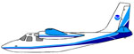
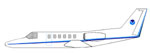
| Rockwell
Aero Commander (AC-500S)
| The
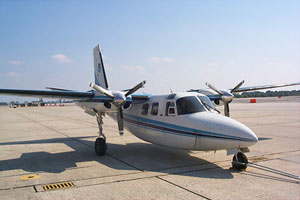
Rockwell Aero Commander (AC-500S) is a versatile
and stable high-winged twin piston-engine aircraft
that is suitable for a variety of missions. Standard
configuration allows for mission equipment and two
pilots. However, with the scientific packages removed,
seating for five additional passengers may be installed.
NOAA's two aero commanders are utilized primarily
as aerial survey platforms for visual verification
of aeronautical charts, high-resolution aerial photography,
and snow water equivalent and soil moisture content
measurements. Additionally, the aircraft has been
used in biological investigations, such as algal
bloom measurements and sea turtle population assessments,
and post-hurricane and severe flood damage assessment
photography. |
 |
STANDARD
AIRCRAFT SPECIFICATIONS
| Type: |
Rockwell
AC-500S Aero Commander |
|
Engines: |
Lycoming
IO-540-E1B5 (piston) |
| Crew: |
2
Pilots + 3 Scientists |
| Ceiling: |
12,500
feet (without supplemental cabin oxygen) 18,000
feet (with supplemental cabin oxygen) |
| Rate
of Climb: |
1750
feet/minute |
| Operational
Airspeeds: |
90-150
knots |
| Electrical: |
Two
28 VDC 100 ampere alternators |
| Max.
Gross Weight: |
6,750
lbs. |
| Empty
Weight: |
5,341
lbs.
(5,621 lbs. including RC-8 Aerial Camera)
(5,756 lbs. including Snow System) |
| Useful
Load: |
1,409
lbs. (fuel, personnel, cargo)
(1,129 lbs. with camera installed)
(994 lbs. with Snow System installed) |
| Fuel
Load: |
958
lbs. (159 gal) |
| Type
Fuel: |
100
LL |
| Standard
Fuel Burn: |
Normal
Cruise Speed - 164 lbs./hr (27.3 gal/hr) Fuel Burn
for specific mission configuration will be calculated
during mission planning and will vary with environmental
conditions. |
| Maximum
Range and Duration: |
@Normal
Cruise - 670 nm @Max. Endurance - 860 nm @Normal
Cruise - 4 hr 30 min @Max. Endurance - 6 hr 10 min
|
| Dimensions
(external): |
Wing
Span - 49 ft 0.6 in
Total Length - 36 ft 9.7 in
Fuselage Height - 14 ft 3.5 in
Tail Height - 14 ft 8.2 in
Forward Cabin Doors - 3 ft 10 in x 1 ft 11in
Aft Cabin Doors - 3 ft 9 in x 2 ft 4 in
Baggage Doors - 1 ft 11 in x 1 ft 7 in |
| Dimensions
(internal): |
Cabin
Length - 10 ft 7.5 in
Cabin Height - 4 ft 5 in
Cabin Width - 4 ft 4 in |
| Useable
Volumes: |
Cabin
- 177 cu ft Baggage compartment - 32 cu ft
Additional Standard Equipment
Cockpit: Weather radar, radar altimeter, GPS navigation
system
Cabin: Camera ports on bottom of fuselage (approx.
1' x 1')
RC-8 aerial camera GPS data port |
 The
aircraft seating arrangement can accommodate a maximum
of five passengers in addition to the two flight crew
members. Two single seats can be installed just behind
the pilot and copilot seats and a bench seat for three
people can be placed at the aft end of the cabin. Passengers
have access to external viewing through any of four
cabin windows, two on each side of the aircraft fuselage
at eye-level. Each of the forward square-shaped cabin
windows measures 16 inches wide by 16.375 inches high.
The aft cabin windows, which are oblique quadrilateral
in shape, measure 16.75 inches wide by 14.5 inches high
at the center of the window. Partial viewing is possible
through the cockpit forward windows and cockpit brow
windows. The
aircraft seating arrangement can accommodate a maximum
of five passengers in addition to the two flight crew
members. Two single seats can be installed just behind
the pilot and copilot seats and a bench seat for three
people can be placed at the aft end of the cabin. Passengers
have access to external viewing through any of four
cabin windows, two on each side of the aircraft fuselage
at eye-level. Each of the forward square-shaped cabin
windows measures 16 inches wide by 16.375 inches high.
The aft cabin windows, which are oblique quadrilateral
in shape, measure 16.75 inches wide by 14.5 inches high
at the center of the window. Partial viewing is possible
through the cockpit forward windows and cockpit brow
windows.
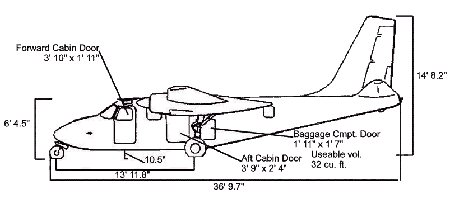
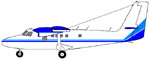
Side View

Side View
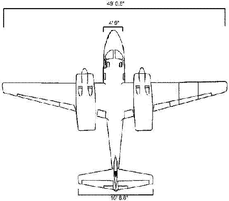
Front View
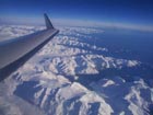
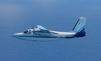
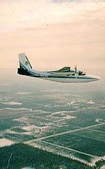
Snow
Survey Platform (N51RF)
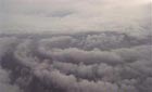
An AC-500S Aero
Commander aircraft is used by the National Operational
Hydrologic Remote Sensing Center (NOHRSC) to conduct
aerial snow survey operations in the snow-affected regions
of the United States and Canada. During the snow season
(January-April), snow water equivalent measurements
are gathered over a number of the 2000+ pre-surveyed
flight lines using a gamma radiation detection system
mounted in the cabin of the aircraft. In the fall season,
the same equipment is used to measure the soil moisture
before snowfall is expected, and to measure the background
radiation signature of new flight lines. During survey
flights, this system is flown at 500 feet above the
ground at ground speeds ranging between 100 and 120
knots. Gamma radiation emitted from the earth is attenuated
by soil moisture in the upper 20 cm of soil and water
mass in the snow cover. Through careful analysis, differences
between airborne radiation measurements made over bare
ground is compared to that of snow-covered ground. The
radiation differences are corrected for airmass attenuation
and extraneous gamma contamination from cosmic sources.
The airmass correction is calculated using the output
from precision temperature, radar altimeter, and pressure
sensors mounted on and within the aircraft. Output from
the Snow Survey system results in a mean areal snow
water equivalent value within +/- one centimeter. Data
collected during snow survey missions, including observed
ground and weather conditions, are used by the National
Weather Service (NWS) and other agencies to forecast
river levels and potential flooding events due to snowmelt
water runoff. Hydroelectric power interests and other
water supply managers also use the data to regulate
water storage and delivery.
Further
information regarding the snow survey program can be
obtained by accessing the National Operational Hydrologic
Remote Sensing Center, Office of Hydrology website at
http://www.nohrsc.nws.gov.
Aircraft
Modifications to N51RF:
- Customized
tail cone with downward looking remote video camera
- Precision
temperature probe mounted on the top of the fuselage
- Trimble
3000 GPS with output port
- Radar
altimeter with analog output
Snow
Survey Platform (N51RF)
The
gamma detection system is composed of the following
equipment:
- Crystal
Box (2.5 ft. x 2 ft. x 1.5 ft., 316 lbs.)
- 7
NaI-Tl scintillation detector crystals
- 7
photomultiplier tubes
- 7
pre-amplifiers
- Equipment
Rack (162 lbs.)
- Nuclear
Instrumentation Module (NIM) bin with 12 volt DC power
supply
- 1
ORTEC 920-8 multi-channel buffer
- 2
summing amplifiers (UP and DOWN)
- 1
analog module (converts temperature sensor, pressure
sensor, and radar
- altimeter
data to digital form)
- 1
Bertan high voltage power supply
- 1
ORTEC 6 volt power supply
- PICODAS
486 computer (PDAS 1000)
- KEITHLEY
METRABYTE DAS 802 card for Analog box input
- ORTEC
918 card for input from the multi-channel buffer
- Double
Talk PC Speech Synthesizer
- Analog
pressure sensor
- DC-to-AC
inverter, power strip, and power circuit breaker switch
- Peripheral
Equipment
- Radar
altimeter
- Analog
temperature sensor
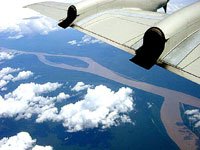
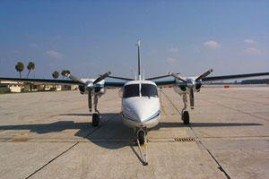
Multi-Purpose
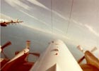
Survey Platform (N47RF)
Aero
Commander N47RF is configured to conduct a variety of
remote sensing missions. The aircraft has been modified
with an 18-inch diameter, belly-mounted camera hatch.
This hatch has a hydraulic door which can be opened
and closed in flight. When closed, the door seals tightly
to protect any instrumentation mounted in the hatch,
and to provide a quieter cabin environment. When open,
the door swings out approximately 160 degrees to provide
an unobstructed view of the earth below. Using different
mounts, a variety of sensors can be installed above
the “hole” to provide remote sensing data.
Additionally, the relatively large diameter of the opening
can, in some cases, allow for the simultaneous mounting
of several complimentary sensors. The aircraft cabin
has a 28v DC scientific power drop and a standard equipment
rack to house data collection computers, video monitors,
GPS systems, or any other electronic support equipment.
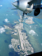
This
aircraft was acquired in 1982 to conduct visual and
photographic surveys of aeronautical charts. In 2000,
the FAA assumed responsibility for these surveys. However,
the photographic component of this mission is still
performed by N47RF. This mission involves the aerial
photography of air traffic obstructions such as towers,
stacks, and buildings. Two pilots perform the mission
with one flying the aircraft and the other operating
the RC-8 aerial camera system. The RC-8 is capable of
taking a series of high-resolution 9-inch x 9-inch photographs
with a pre-selected overlap. These photo series are
then used to extract height and location information
for each obstruction. In addition to obstruction photography,
the RC-8 can and has been used for post-disaster photography
to document the damage caused by hurricanes, floods,
fires, etc.
Besides
the RC-8 camera system, the aircraft has also been flown
with numerous other sensor systems including hyperspectral
imagers, infrared.video cameras, and digital still cameras.
These systems have been utilized to detect red tides,
measure the health of kelp forests and coral reefs,
and to study the effects of wind and current on the
oceans surface.
When
not employing remote sensors, the aircraft is an outstanding
visual survey platform as well. With the high-wing design
pilots are afforded very good visibility. In addition,
forward, rearward, and downward visibility is improved
by two bubble windows installed in the forward cabin
area. The enhanced visibility, as well as the Aero Commander's
ability to fly low at slow airspeeds while remaining
highly maneuverable, makes this aircraft a capable tool
for survey or patrol duty. Past projects include Right
Whales surveys off the New England coast, Turtle Surveys
off the Mid-Atlantic coast, and fish surveys along the
Gulf Coast.
Click here for the Digital Snow Survey Movie |