Major Highlights
JUNE TEMPERATURES HIGHER, PRECIPITATION NEAR AVERAGE
For June 2005, temperatures throughout the contiguous United States were higher than average, according to National Oceanic and Atmospheric Administration scientists at NOAA's National Climatic Data Center in Asheville, N.C. Drier-than-average conditions prevailed from Texas to the Midwest and Northeast, while areas of the Southeast, northern Plains and West were wetter than average. Precipitation was near average for the nation as a whole. Also, the global land surface temperature was warmest on record for the month.
US Temperature:
The average temperature for the contiguous United States for June (based on preliminary data) was 0.9°F (0.5°C) above the 1895-2004 mean. Warmer-than- average conditions from the Northeast to the Upper Midwest contrasted with near average and cooler-than-average conditions across the West and Southeast.
New York State had its warmest June on record, with 12 other states from Minnesota to Maine ranking much above normal for the month. Wisconsin, Michigan, and Vermont had their second warmest June on record. Much of the anomalous warmth occurred in the second week of the month, when mean temperatures in parts of the Northeast quarter of the country exceeded 10°F above average. The statewide temperature for Alaska was 3.0°F (1.7°C) above the 1971-2000 mean, the third warmest June since statewide records began in 1918.
US Precipitation:
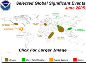
Unusually dry conditions stretched from Texas to the Midwest and Northeast, while wetter-than-normal conditions were widespread in the Southeast, northern Plains, and parts of the West. North Dakota had its wettest June on record and precipitation was much above average in seven other states (S.C., Ga., Fla., S.D., Neb., Mont., Calif.) June marked the fourth consecutive drier-than-normal month for parts of the southern Plains and Midwest, with large areas of worsening drought from eastern Texas to northern Illinois and Indiana.
By contrast, average-to-above-average rainfall in parts of the Pacific Northwest and northern Rockies provided additional relief to some areas, which have experienced drought for much of the past six years. As measured by the Palmer Drought Index the percent of the West affected by moderate-to-extreme drought changed little since May, remaining at 11 percent. The area affected by moderate-to-extreme drought in the contiguous U.S. rose from 8 percent to 13 percent.
June 2005 also became the most active early period on record for the Atlantic hurricane season, with four named storms (Arlene, Bret, Cindy and Dennis) forming by July 5.
Globe:
The average global temperature for combined land and ocean surfaces for June (based on preliminary data) was 1.1°F (0.60°C) above the 1880-2004 long-term mean.� This was the second warmest June for combined land and ocean surface temperatures since 1880 (the beginning of reliable instrumental records), slightly cooler than June 1998.� For global land surfaces alone, June 2005 set a new record with a temperature that was 1.9°F (1.06°C) above average.� Widespread anomalous warmth covered much of the Asian continent, Western Europe, Canada and the eastern half of Australia.� The global ocean surface temperature was second warmest on record and neutral ENSO (El Ni�o/Southern Oscillation) conditions were present in the equatorial Pacific.
A heat wave, which began in May 2005 across areas of South Asia, continued into late June. Hundreds of people reportedly died as a result of temperatures reaching 113°F-122°F (45°C-50°C) in parts of India, Pakistan, Bangladesh and Nepal. A heat wave in Italy in late June was the most severe in the northern part of the country since 2003 and drought conditions were widespread with the river Po at historically low levels. Conversely, seasonal flooding, which began in May 2005 across southern China, continued in June and impacted more than nine million people in sections of Hunan, Guangdong, Chongqing, Sichuan, Guizhou and Guangxi provinces.
|
 NCDC / Climate Monitoring / Climate of 2005 / June / Search / Help