 NCDC / Climate Monitoring / Climate of 2005 / Snow Summary / Search / Help NCDC / Climate Monitoring / Climate of 2005 / Snow Summary / Search / Help
Use these links to access detailed analyses of Global and U.S. data. 
|


 larger image |
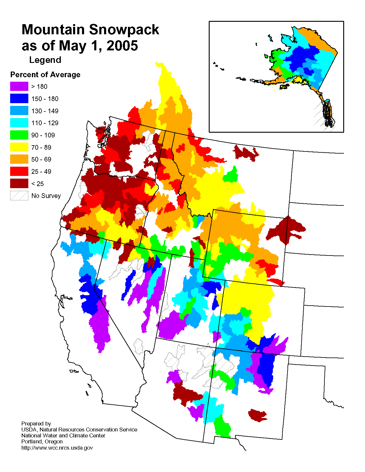
The map to the left depicts the percent of average seasonal snowpack across the western U.S. as of May 1st. Despite some much needed rain and snow for the Pacific Northwest during spring (March-May), snowpack and snow water content in the Northwest still reflected the lack of winter precipitation with areas of Washington and Oregon having less than 25% of their normal snow. The Southwest maintained an above average snowpack during the snow season with some areas (central Sierra Nevada, parts of Utah) over 125% of normal, even at the end of May. This was mostly due to a series of Pacific storms impacting the region through the winter. Interior Alaska also had above average snowpack, while the northern and southern coasts of the state received less than average snow for the 2004-2005 snow season. |
|
Parts of Europe and Asia had colder-than-average conditions and large snow accumulations during the winter and spring, including more than 6 feet (2 meters) of snow in March in Serbia and Montenegro, and along the northern shores of the Mediterranean in February. In the U.S., late season snow fell in Colorado during April, leaving well over 2 feet of snow in Denver and surrounding mountain areas (image right). The Great Lakes south to the southern Appalachians also received snowfall during the last week of April, leaving over a foot of accumulation in parts of Ohio. |
 larger image |
 March
March
 click here for animation |
 click here for animation |
|
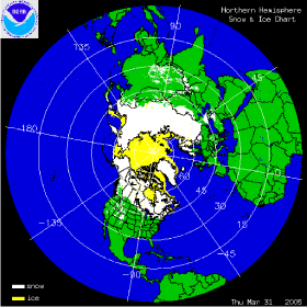
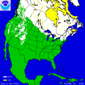
The two images above show the daily snow cover across the Northern Hemisphere (left map) and North America (right map) throughout March 2005. The maps show snow cover on March 31st, illustrating the retreat of snowpack compared to end of February. The snowy winter in Europe continued into early March and was followed by gradual melting and snow cover retreat through the latter half of the month. Most of Siberia, northern Scandinavia, Canada and Alaska remained snow covered at the end of March. A late season storm brought rain and snow to the northeastern US at the beginning of April (2nd-4th) and led to flooding in Pennsylvania, New Jersey and New York. Over 20 inches of snow fell across northwestern PA and southwestern NY producing flood stages that rivaled levels recorded during Hurricane Ivan in September 2004. More information on significant winter weather and other hazards can be found on NCDC's Hazards page. |
 larger image |
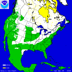
The map to the left depicts the percent of average seasonal snowpack across the western U.S. as of April 1st. Despite some much needed rain and snow for the Pacific Northwest during March, snowpack was still much below average for the season, with areas of Washington and Oregon having less than 50% of their normal snow. The Southwest maintained an above average snowpack during March with many areas over 150% of normal. This was mostly due to a series of Pacific storms impacting the region through the winter. Interior Alaska also had above average snowpack, while the northern and southern coasts of the state received less than average snow for the 2004-2005 winter season. |
February
 click here for animation |
 click here for animation |
|
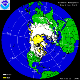
The two images above (click to animate) show the daily snow cover across the Northern Hemisphere (left map) and North America (right map) throughout the month of February 2005. The map to the left shows snow cover on February 28th, illustrating the culmination of a snowy winter for much of Europe. Heavy snow and avalanches also impacted the India/Pakistan border in February killing as many as 230 people in India. More snow fell across the Northeast U.S. in February with an additional 17.7 inches during the month for Boston, bringing the winter total to 68.2 inches for the city. Snow also continued to fall across the Southwest in February, maintaining much above average snowpack for the region. More information on significant winter weather and other hazards can be found on NCDC's Hazards page. |
 larger image |
The map to the left depicts the percent of average seasonal snowpack across the western U.S. as of March 1st. In stark contrast to well above average snowpack in the Southwest, the Northwest has had below average snowfall this snow season and this is reflected in the lower snowpack percentages. As reported by the USDA, several individual stations in the remote high altitude SNOTEL network set new record lows (in the north) and highs (in the south) for both snow water content and water-year-to-date accumulated precipitation. Many stations in the Pacific Northwest and northern Rockies shattered snow water content records set during the record dry 1976-77 winter. Snowpack conditions in Alaska were generally above normal in the interior regions, below normal in coastal areas. |
January
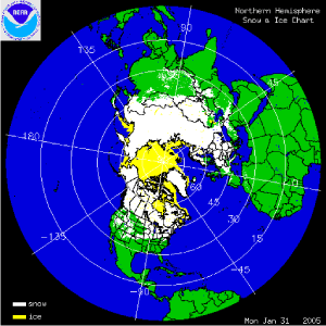 click here for animation |
 click here for animation |
|
The two images above (click to animate) show the daily snow cover across the Northern Hemisphere (left map) and North America (right map) throughout the month of January 2005. The map to the right shows snow cover on January 31st after several days of winter storms affected much of Europe. The severe weather led to at least 6 deaths and a state of emergency declaration in Bulgaria (CBS/AP). Dozens of villages were cut off by the snowfall across Greece and Albania, while the risk of avalanches increased across much of central and eastern Europe. Rare snow fell on Rome, Italy, and even the island of Mallorca in the Mediterranean Balearic Islands (east of Spain) had some snow during the blast of wintry weather across Europe. From the same storm system, the Algerian capital had its heaviest snow in 50 years (Reuters). Two days of snowfall in Algiers caused as many as 13 deaths and over 40 injuries, also paralyzing the northern Algerian public transportation system. More information on significant winter weather and other hazards can be found on NCDC's Hazards page Heavy snow fell across the Midwest and Northeast U.S. Nearly a foot of snow fell at Chicago O'Hare Airport, while parts of New England, and especially eastern Massachusetts also had substantial snow accumulations. Widespread snow amounts exceeding a foot were evident across southeastern New England and over 2 feet of snow fell across parts of far eastern Massachusetts and Cape Cod. Boston concluded January with its snowiest month on record with a total of 43.1 inches. Worcester, MA had its snowiest January and second snowiest month on record with 51.1 inches. |
 larger image |
The map to the left depicts the percent of average seasonal snowpack across the western U.S. as of February 1st. In stark contrast to well above average snowpack in the Southwest, the Northwest has had below average snowfall this snow season and this is reflected in the lower snowpack percentages. Much of the West is reliant on winter precipitation to refill reservoirs in preparation for the higher summer water demand. It is the 6th year of drought in parts of the northern Rockies and High Plains. However, record-breaking snow fell during late December and early January in parts of the southern West. A series of storms that also led to devastating rain and flood damage in southern California, left well over 10 feet of snow in the higher locations of the Sierra Nevada. Even areas below 7000 ft in the Sierra received snowfall totalling 4-6 feet in accumulation. Nevada, northern Arizona and Utah also received much above average snowfall for the month and percent of seasonal snowpack was over 150% in some parts of the southern West at the end of January. |
|
Sea ice increased across the Great Lakes in January 2005 with Lake Erie being almost completely ice-covered and Lake Ontario remaining ice-free only in the center of its surface. Lakes Huron, Superior and Michigan still had substantial ice-free areas in early February, though lake-surface temperatures were below 40�F across all lakes. Northern Hemisphere January sea-ice extent was the lowest on record for the month in 2005, with an area of 14.8 million km2. Satellites have been able to estimate sea ice extent since 1978 and the trend in January Northern Hemisphere sea ice extent since 1979 is -2.9% per decade (data and graphic courtesy of the National Snow and Ice Data Center). |
 larger image |
December
 click here for animation |
As can be seen in the animated image to the left, several significant snow storms affected the continental U.S. during December while most of Canada was snow-covered for the entire month. Sea ice increased over Hudson Bay and water bodies in the Canadian interior, while the Great Lakes remained ice-free during December. A notable snow event was captured in the image to the left as snow fell in southern Texas over the Christmas holiday. Over a foot was recorded in Victoria, Texas, while Brownsville, at the southern tip of the state, received 1.5 inches. A snow storm that impacted the Ohio Valley on the 22nd and 23rd caused parts of Indiana and Kentucky to receive more than their average seasonal total in just one day. More information is also available on NCDC's December Hazards page. |
November
| As can be seen in the animated image to the right, snow extent further increased across North America during November, with anomalously sustained snow cover for the time of year in west-central Canada and parts of the western U.S., with less than average snow cover through the month in the upper Midwest. A major snowfall event occurred across areas of the West over the Thanksgiving weekend on the 28th and 29th. More details on November snowfall will be available in the coming days. |
 click here for animation |
October
| As can be seen in the animated image to the right, snow extent increased across North America during October, with anomalously sustained snow cover for the time of year in central and western Canada, and less than average snow cover for eastern Canada and southwestern Alaska. The first major snowfall of the season occurred for areas of the West as two large storms brought heavy snow to some western states, including California. Snow water content was also above average for basins in Wyoming, Montana and New Mexico at the end of October. |
 click here for animation |
 larger image |
The graphs to the left show snow cover extent and departures from average for the contiguous US (top) and Alaska (bottom). Despite the advance of continental snow cover during October (as can be seen from the red line), snow cover extent was still below average for both Alaska and the contiguous US for the month (shown by the blue bars). Alaska had 51,000 km2 less snow cover than average, while the contiguous US had -92,000 km2 less than the mean. However, snow cover across Canada was greater than the October average leading to a positive anomaly of 550,000 km2 for the whole of North America. (Averages are calculated based on data from Nov 1966 to present). |
| The image to the right shows a MODIS satellite image taken on October 31st from NASA's Terra satellite. Snow is visible on the Sierra Nevada Mountains of California following the second major storm in as many weeks to hit the state. Several feet of snow fell in some mountain locations and ski-resorts were able to open early. |
 larger image |
|
See NCDC's snow climatology page for snow statistics for U.S.states and stations. |
Early Season
| Snow cover extent began to increase in the northern areas of North America as can be seen in the animated image to the right. Some early season snowfall also occurred in the Canadian and U.S. Rockies. Anchorage, Alaska had its highest September snowfall on record (6 inches), all of which fell in one day (September 25th), also breaking the old record for the heaviest 24-hour snowfall for the month of September in Anchorage. |
 click here for animation |
 larger image |
Although some early snow fell in parts of the western mountains, monthly snow cover extent for the contiguous U.S. was near zero square kilometers as can be seen in the graph to the left. For September, the average snow cover extent is approximately 12,000 square kilometers for the nation, with an additional 184,000 km2 for Alaska. Alaska also had below average snow cover for September with 97,000 km2 less than average. |
|
See NCDC's snow climatology page for snow statistics for U.S.states and stations. |
Useful Links
|
|
Questions?
For all climate questions other than questions concerning this report, please contact the National Climatic Data Center's Climate Services Division:
| Climate Services Division NOAA/National Climatic Data Center 151 Patton Avenue Asheville, NC 28801-5001 fax: 828-271-4876 phone: 828-271-4800 email: questions@ncdc.noaa.gov |
For further information on the historical climate perspective presented in this report, contact:
|
Jay Lawrimore NOAA/National Climatic Data Center 151 Patton Avenue Asheville, NC 28801-5001 fax: 828-271-4328 email: Jay.Lawrimore@noaa.gov |
NCDC / Climate Monitoring / Climate of 2005 / Snow Summary / Search / Help
Downloaded Wednesday, 24-Sep-2008 13:44:32 EDT
Last Updated Monday, 15-Aug-2005 11:15:36 EDT by Anne.Waple@noaa.gov
Please see the NCDC Contact Page if you have questions or comments.