A
Keyhole Markup
Language file has been created to view
Wetlands Data with Google Earth. Please note that Google Earth
version 4.2, or higher, is required to run this file. To ensure that you use the latest
version, it is recommended that you always load the file and open
Google Earth by selecting the link below:
WetlandsData.KMZ
(last modified on July 2, 2008)
If Google Earth fails to launch automatically, the file can also
be used by first launching the Google Earth application. Select
the menu option File, Open, and then
locate the previously downloaded file (WetlandsData.KMZ); then click the
Open button.
|
|
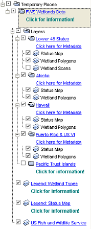
Notes:
- Double click any layer title to zoom into its area
- Click on any
layer checkbox to view or hide the image layer
- Click on any
legend checkbox to view or hide it
- The Lower 48 States Wetland
Scans layer is hidden by default. To view the image layer, first
zoom into an area that has Wetland Scans information, then turn
on the layer.
- Important: Do not leave the Wetland Scans
layer on (checked) while viewing areas that do not
have scanned data. A large red
X will
appear if you do so.
- If two versions of Google Earth are currently
installed on your computer, it is recommended that the oldest
version (and its associated desktop icon) is removed from your
computer.
- To remove the Wetlands KMZ file from Google Earth,
right-click on the FWS Wetlands Data folder located under Places
(Google Earth left panel), then select Delete.
-
Viewing Wetlands Data w/Google Earth Fact Sheet
(1MB PDF)
|
Google
Earth file content menu:
 |
|
Please visit our
Map
Creation and Mapper Display page for more tips and technical
information. The data are available through an OGC compliant
Web Map
Service.
*
Disclaimer and Data User Caution
Digital data available on
this site represent the latest, most accurate information
available from the U.S. Fish and Wildlife Service's National
Wetlands Inventory. These data are also available on
The National
Map.
|
|