
Thunderstorm Hazards - Tornadoes
 A tornado is a violently rotating (usually counterclockwise in the northern hemisphere) column of air descending from a thunderstorm and in contact with the ground. Although tornadoes are usually brief, lasting only a few minutes, they can sometimes last for more than an hour and travel several miles causing considerable damage.
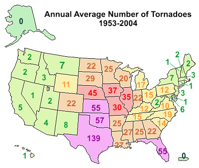
The United States experiences more tornadoes by far than any other country. In a typical year about 1000 tornadoes will strike the United States. The peak of the tornado season is April through June and more tornadoes strike the central United States than any other place in the world. This area has been nicknamed "tornado alley."
 Most tornadoes are spawned from supercell thunderstorms. Supercell thunderstorms are characterized by a persistent rotating updraft and form in environments of strong vertical wind shear.
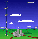
Wind shear is the change in wind speed and/or direction with height. (For more about shear - click on images at left).
The updraft lifts the rotating column of air created by the speed shear. This provides two different rotations to the supercell; cyclonic or counter clockwise rotation and an anti-cyclonic of clockwise rotation.
 The directional shear amplifies the cyclonic rotation and diminishes the anti-cyclonic rotation (the rotation on the right side of the of the updraft in the illustration at left). All that remains is the cyclonic rotation called a mesocyclone. By definition a supercell is a rotating thunderstorm.
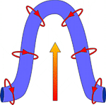
 When viewed from the top, the counter-clockwise rotation of the mesocyclone gives the supercell its classic "hook" appearence when seen by radar. As the air rises in the storm, it becomes stretched and more narrow with time.
The image (below right) is from the doppler radar in Fort Worth, Texas, March 28, 2000. This image was taken at 7:10 p.m., about one hour after a tornado moved through downtown Fort Worth, TX. This image shows the second tornado that day in the Metroplex.
 The colors indicate the intensity of the rain with green representing light rain, the yellow and orange for moderate rain and reds for the heaviest rain and hail. The classic "hook" pattern of the supercell from which a tornado was observed can be clearly seen.
See if you can spot the hook. Hint: look where the rain is most intense (the different shades of red). To see an overlay of the hook, move the your mouse over the image.
The exact processes for the formation of a funnel are not known yet. Recent theories suggest that once a mesocyclone is underway, tornado development is related to the temperature differences across the edge of downdraft air wrapping around the mesocyclone.
However, mathematical modelling studies of tornado formation also indicate that it can happen without such temperature patterns; and in fact, very little temperature variation was observed near some of the most destructive tornadoes in history on May 3, 1999 in Oklahoma.
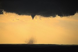 The funnel cloud of a tornado consists of moist air. As the funnel descends the water vapor within it condenses into liquid droplets. The liquid droplets are identical to cloud droplets yet are not considered part of the cloud since they form within the funnel.
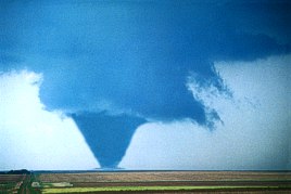 The descending funnel is made visible because of the water droplets. The funnel takes on the color of the cloud droplets, which is white.
Due to the air movement, dust and debris on the ground will begin rotating, often becoming several feet high and hundreds of yards wide.
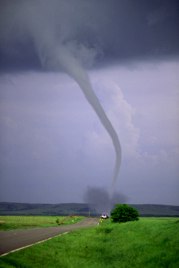
After the funnel touches the ground and becomes a tornado, the color of the funnel will change. The color often depends upon the type of dirt and debris is moves over (red dirt produces a red tornado, black dirt a black tornado, etc.).
 Tornadoes can last from several seconds to more than an hour but most last less than 10 minutes. The size and/or shape of a tornado is no measure of its strength.
Occasionally, small tornadoes do major damage and some very large tornadoes, over a quarter-mile wide, have produced only light damage.
The tornado will gradually lose intensity. The condensation funnel decreases in size, the tornado becomes tilted with height, and it takes on a contorted, rope-like appearance before it completely dissipates. Learn more about tornadoes from the NWS Storm Prediction Center's FAQ.
The Enhance F-Scale
| EF scale |
Class | Wind speed | Description | |
|---|---|---|---|---|
| mph | kph | |||
| EF0 | weak | 65-85 | 105-137 | Gale |
| EF1 | weak | 86-110 | 138-177 | Moderate |
| EF2 | strong | 111-135 | 178-217 | Significant |
| EF3 | strong | 136-165 | 218-266 | Severe |
| EF4 | violent | 166-200 | 267-322 | Devastating |
| EF5 | violent | > 200 | > 322 | Incredible |
The Fujita (F) Scale was originally developed by Dr. Tetsuya Theodore Fujita to estimate tornado wind speeds based on damage left behind by a tornado. An Enhanced Fujita (EF) Scale, developed by a forum of nationally renowned meteorologists and wind engineers, makes improvements to the original F scale. This EF Scale has replaced the original F scale, which has been used to assign tornado ratings since 1971.
The original F scale had limitations, such as a lack of damage indicators, no account for construction quality and variability, and no definitive correlation between damage and wind speed. These limitations may have led to some tornadoes being rated in an inconsistent manner and, in some cases, an overestimate of tornado wind speeds.
 The EF Scale takes into account more variables than the original F Scale did when assigning a wind speed rating to a tornado. The EF Scale incorporates 28 damage indicators (DIs) such as building type, structures, and trees. For each damage indicator, there are 8 degrees of damage (DOD) ranging from the beginning of visible damage to complete destruction of the damage indicator. The original F Scale did not take these details into account.
For example, with the EF Scale, an F3 tornado will have estimated wind speeds between 136 and 165 mph (218 and 266 kph), whereas with the original F Scale, an F3 tornado has winds estimated between 162-209 mph (254-332 kph). The wind speeds necessary to cause "F3" damage are not as high as once thought and this may have led to an overestimation of some tornado wind speeds.
There is still some uncertainty as to the upper limits of the strongest tornadoes so F5 ratings do not have a wind speed range. Wind speed estimations for F5 tornadoes will be left open ended and assigned wind speeds greater than 200 mph (322 kph).