|
 |
 |
 |
|
 |
Burien-SeaTac-Tukwila-Renton Map and Guide
in the Virtual Map Counter
August 23
Vashon–Maury Island Parks & Natural Lands Map and Guide in the Virtual Map Counter
August 15
Introducing the King County GIS Center
July 24
KingCounty.gov Debuts
June 22
KCGIS Client Services Helps Site Park & Rides
June 20
King County GIS Online Mapping Survey Ends
June 18
Speak Your Mind, Win a Prize—It's User Survey Time Again
May 21
KCGIS
at the Washington GIS Conference
May 2
KCGIS
Users Group Schedule Change
April 30 Get Ready for GIS Boot Camp
April 6
KCGIS
Center Trainer in ESRI Top 5 Again
April 19
A Big Step Up for iMAP Printing
April 2
2005 Aerial
Photos Now in iMAP
March 12
Easier iMAP Property Searches
March 12
January
2007 KCGIS Data Disk Now Available
January 22
New Map Set for iMAP: Shoreline Master Program
January 18 |
|
 |
Burien-Seatac-Tukwila-Renton Map and Guide
in the Virtual Map Counter
August 23, 2007
 The KCGIS Center in coordination with Public Health of Seattle and King County, KC Parks and the cities of Burien, Renton, Sea Tac, and Tukwila have produced a map/guide to promote recreational activities within this region of the county. The KCGIS Center in coordination with Public Health of Seattle and King County, KC Parks and the cities of Burien, Renton, Sea Tac, and Tukwila have produced a map/guide to promote recreational activities within this region of the county.
KCGIS Center cartographers worked closely with parks staff to gather information on parks, trails, bike lanes, play grounds and community centers. The guide side of the page displays information from each city plus an amenities chart for selected parks or trails.
You can get your own copy by contacting King County Parks, or by stopping by the Roads Services map counter on the first floor of the King Street Center building. Or you can download and print your own version from the Virtual Map Counter.
More:
King County Parks

|
Vashon–Maury Island Parks & Natural Lands Map and Guide in the Virtual Map Counter
August 15, 2007
 The KCGIS Center has just published a new recreation map and guide for Vashon Island. It was commissioned by the Vashon Park District and Vashon-Maury Island Land Trust to promote outdoor opportunities available on the island. The KCGIS Center has just published a new recreation map and guide for Vashon Island. It was commissioned by the Vashon Park District and Vashon-Maury Island Land Trust to promote outdoor opportunities available on the island.
The map includes topographic detail to help users see the bluffs and stream systems in the area, while the guide includes a recreation chart for parks and facilities, photographs for a number of sites and descriptive text for things to see and do. The Vashon–Maury Island Parks & Natural Lands Map and Guide made its debut at the Vashon Strawberry Festival in July.
Vashon Island features 30 parks and natural preserves that offer a variety of activities, including swimming, hiking, wildlife viewing and more. In addition, King County manages more than 800 acres of land on Vashon-Maury Island, including the popular Dockton Park, the ecologically valuable Island Center Forest.
You can get your own copy by contacting the Vashon Park District, the Vashon-Maury Island Land Trust, King County Parks, or by stopping by the Roads Services map counter on the first floor of the King Street Center building. Or you can download and print your own version from the Virtual Map Counter.
More:
Vashon Park District
Vashon-Maury Island Land Trust
King County Parks
|
Introducing the King County GIS Center
July 24, 2007
If a picture (or a web site) is worth a thousand words, a video can be an even more powerful medium to help you learn about GIS technology and discover how it is used by King County. In our premier video offering King County GIS Center staff members take you on a four-minute tour of our operations, describes typical GIS business applications, and spotlight some of the GIS resources that are ready for you to use.
Lights, Camera, Action…
Windows Media format
Real Media format
KingCounty.gov Debuts
June 22, 2007
Revolutionary changes in the King County website have begun with the introduction of www.kingcounty.gov to replace www.metrokc.gov, and the launch of a new home page design. These and more changes to come will make the King County website more user-friendly and an even more accessible source for a wealth of information and services, including GIS services.
Visitors to the King County GIS Center website won't notice any changes right away, except in the King County e-mail address format which now looks like this:
firstname.lastname@kingcounty.gov.
We'll revise the e-mail links on our site to make the change transparent for users who contact us that way. The old metrokc.gov addresses will still work for several more months, but if you have King County e-mail addresses in your address books, it would be a good idea to update them soon. And www.metrokc.gov/gis will continue to bring you right here during a gradual transition period as we, along with all King County departments and
divisions work on revising our sites to adopt the look and feel of the new King County home page.
The new layout of the King County home page is service-oriented and includes a "Maps" link under the "Essentials" heading. This link takes visitors directly to the KCGIS Center map portal, where they can connect to the popular and heavily used Parcel Viewer and iMAP interactive mapping applications, and
to a wide variety of other maps and map resources.
|
KCGIS Client Services Helps Site Park & Rides
June 20, 2007
KCGIS Center Client Services recently completed a project for Metro Transit Service Development that may help ease commuter pressures in the Metro service area. Earlier this year, Metro employees captured a one-day snapshot of vehicle origins from seventy-five park and ride lots in King County. KCGIS Center Client Services processed this information, loaded the resulting data into ArcGIS, and then geocoded
and mapped thousands of vehicle origin points.
Client Services proceeded to analyze the distribution of the these spatial points to delineate the area that contained the home locations of the nearest 80% of users for each park and ride lot. The project included comparisons of the new data to those from a similar effort in 2002. The maps and analyses from this project will help Metro determine where to expand existing park and ride lots and locate new ones to better serve existing
transit users and make it easier for more commuters to make the switch to public transit.
|
King County GIS Online Mapping Survey Ends
June 18, 2007
A
big Thank You to the many hundreds of iMAP
and Parcel Viewer users who participated
in this year's survey. We're compiling and
analyzing the results now from the 525 responses
(almost 80% more than we received last year!).
Our 2006 survey analysis led to many small
and major revisions to our online mapping
applications. Stay
tuned for our 2007 results.
More:
|
 Speak
Your Mind, Win a Prize—It's User Survey
Time Again Speak
Your Mind, Win a Prize—It's User Survey
Time Again
May 21, 2007
Note:
archived article, survey ended June 15th.
Our latest easy
online
survey, which you can complete
in
five minutes or less, will
give us valuable feedback and give you
a chance to win a prize (see
how below).
Our
online mapping applications, iMAP and Parcel
Viewer, meet a broad range of user needs.
First-time or occasional users might look
up information about one particular piece
of property. Others have come to rely on
these tools as part of their day-to-day business.
We are constantly working on new ways to
make iMAP and Parcel Viewer easy to use for
a wide and diverse audience, and to make
the user experience more and more productive.
Now is your chance
to help by telling us about your experiences
using iMAP and/or Parcel Viewer. For the
next four weeks you can take a quick
and easy online survey that will help make these
great tools even better. Nearly 400 survey
respondents a year ago provided key feedback
that helped guide us in making numerous improvements,
including those reported earlier in this
space, such as iMAP's printing
function,
map
measuring tool, and map
design.
We
need your feedback, and we've made it easy
for you. Just go to the survey
pages and select from the mostly
multiple choice responses (add your written
comments if you wish). All survey takers
(except King County employees and their families)
who leave contact information will be eligible
for a random drawing for this year's prize,
the 2008 edition of the Thomas Guide® for
King, Pierce, and Snohomish counties. The
survey will be available online from
May 21 through June 15. The prize drawing
will be held on June 20th. And you
can count on the survey results appearing
in the form of the ongoing services provided
to the community by iMAP and Parcel Viewer.
|
KCGIS
at the Washington GIS Conference
May 2, 2007
King County GIS
fielded a strong presence at the recently
concluded 2007 Washington GIS Conference.
The Washington Chapter of the Urban and Regional
Information Systems Association produced
and sponsored this annual conference which
was held this year at the Lynnwood Conference
Center from April 23–25. The event
included a day of pre-conference workshops,
two days of presentations in concurrent management,
technical, and exhibitor tracks, and a professional
and student map and poster contest.
Leading the King
County participation was County Executive
Ron Sims who delivered the conference keynote
address. Long a champion of GIS technology
and regional coordination, Sims used such
examples as the county's Greenprint Project—an
open space and resource lands conservation
and acquisition strategy that relies on GIS
modeling, and the role of GIS in endangered
species recovery planning to recognize conference
attendees for the value that their ongoing
and innovative work provides to the community.
 As part of the
pre-conference workshop lineup, the KCGIS
Training Program presented the inaugural
version of its GIS for Analysts Boot Camp.
More than 75 attendees took advantage of
a coordinated package of KCGIS custom training
classes designed by working GIS professionals
for working GIS professionals. As part of the
pre-conference workshop lineup, the KCGIS
Training Program presented the inaugural
version of its GIS for Analysts Boot Camp.
More than 75 attendees took advantage of
a coordinated package of KCGIS custom training
classes designed by working GIS professionals
for working GIS professionals.
 The
schedule of conference presentations and
panel discussions featured additional KCGIS
staff participation on the topics of GIS
performance measures, enterprise GIS funding,
publication cartography, and custom application
development. KCGIS carried its representation
onto the vendor floor with an exhibit booth
that gave conference attendees a complete
overview of KCGIS Center services via maps,
flyers, video, and direct access to key KCGIS
Center staff. The
schedule of conference presentations and
panel discussions featured additional KCGIS
staff participation on the topics of GIS
performance measures, enterprise GIS funding,
publication cartography, and custom application
development. KCGIS carried its representation
onto the vendor floor with an exhibit booth
that gave conference attendees a complete
overview of KCGIS Center services via maps,
flyers, video, and direct access to key KCGIS
Center staff.
") At
the close of the conference, “Western
King County,” an
aerial photo map created by King County GIS
Center Client Services for Enterprise Seattle
and the King County Office of Business Relations
and Economic Development received the
Best Map award in the map and poster contest
professional category as voted upon by the
conference attendees. At
the close of the conference, “Western
King County,” an
aerial photo map created by King County GIS
Center Client Services for Enterprise Seattle
and the King County Office of Business Relations
and Economic Development received the
Best Map award in the map and poster contest
professional category as voted upon by the
conference attendees.
More:
|
KCGIS Users Group Schedule Change
April 30, 2007
The King County
GIS Users Group is switching from a monthly
to a bi-monthly meeting interval. The next
meeting of the group will be Wednesday, June
6. There will be no May meeting.
All other aspects
of the KCGIS Users Group remain the same.
Full details can be found on the Users
Group page.
|
KCGIS
Center Trainer in ESRI Top 5 Again
April 19, 2007
For the second
year in a row King County GIS Center Training
Coordinator, Cheryl Wilder, has cracked the
ESRI Top 5 list of authorized instructors
for the first quarter of the year based on
number of students taught. Cheryl teaches
ESRI-Authorized classes in the use of ArcView
3 and ArcGIS 9. She receives consistently
high ratings from her students, as well as
frequent praise: "She is an excellent
instructor, very patient, and very willing
to work with students," "Cheryl
has an excellent teaching tempo...I would
recommend her to others,"
"Cheryl was a fabulous instructor."
The KCGIS Center
offers affordable ESRI-Authorized instruction,
plus a growing catalog of custom GIS classes
and workshops developed and taught by working
GIS professionals for GIS professionals,
and for anyone who can benefit from a better
understanding of GIS concepts, practices,
and resources.
Classes are held
in the KCGIS Center's fully equipped, state-of-the
art computer training facility, which is
conveniently located
in the historic Pioneer Square neighborhood
at the edge of downtown Seattle. KCGIS training can also come to
your work site.
To see all of the
education opportunities and the full range
of benefits of KCGIS training, visit the
KCGIS
Training Program pages.
|
Get
Ready for GIS Boot Camp
April 6, 2007
[Note:
the May 2007 Boot Camp has been cancelled.
Watch the KCGIS Center home page news for
updates about the October session.]
The King County
GIS Center Training Program is offering
a new way to ramp up or hone your GIS skills—a
selection of custom KCGIS classes will be
offered in one concentrated four-day package.
It's our first ever GIS Boot Camp.
Boot Camp attendees
will be able to take up to six classes over
the four days to sharpen existing skills
and pick up new ones in such key GIS subjects
as data editing and analysis, geoprocessing,
data queries, and metadata management. Five
of the offerings come from our existing catalog
of classes that we've developed in-house
by drawing upon the depth of our staff's
experience to target the real-world
needs of working GIS professionals.
The sixth
class will be the debut of "Essentials
for Editing and Analysis with ArcGIS." This
class will be a boon to any GIS analyst who
is trying to keep up with the increasing
complexity of editing-related topics,
such as tools and techniques,
the editing environment, topology, workflow,
and versioning.
GIS Boot Camp will
be held at
our convenient and fully equipped downtown
Seattle/Pioneer Square training
facility. Take one or all of the six
classes. Discounts of up to 30% off our regular
single-class prices are available for taking
multiple classes during Boot Camp.
See the full roster
of Boot Camp classes, and all of the information
you will need to take advantage of this exciting
new GIS training opportunity, at our new
GIS
Boot Camp web page.
|
A Big Step Up for iMAP Printing
April 2, 2007
Map print layouts
in iMAP are now created in Adobe Acrobat
PDF format, which makes viewing, saving,
printing and sharing your map layouts easier
than ever. Zoom, pan, save, print and more
with all of the controls in Adobe's
Acrobat Reader. There's a good chance you
already have Acrobat Reader on your computer.
If not, download it free from the Adobe
website.
You can
still choose a landscape or
portrait orientation on any of three page
sizes for your map layout. But printing your
layouts is much easier since you no longer
have to reset your browser to the orientation
and size of your layout to get the correct
print output—Acrobat automatically
fits your map layout to your selected page
dimensions.
Have you had trouble
with lengthy map legends when printing from
iMAP? Trouble no more—a second print
page is automatically created if necessary
to handle the map legend.
Give iMAP printing
a try. Just click the same familiar iMAP
print button to start a new custom map layout.
More:
|
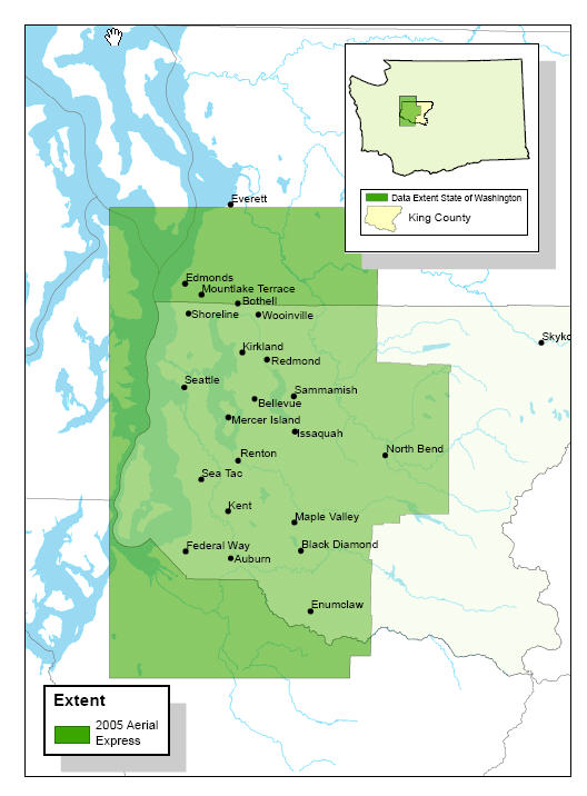
2005 Aerial
Photos Now in iMAP
March 12, 2007
 The
King County GIS Center is pleased to announce
the addition of 2005 color aerial photos,
at one-foot-per-pixel resolution, to all
iMAP map sets. The
new photos, acquired last year from Aerials
Express, represent
the first wide-scale aerial imagery update
for King County since 2002. Because the local
geography can change so rapidly, as shown
in the accompanying illustration
(hover your mouse cursor over the image to
compare photos),
the King County GIS Center has now budgeted
funds to acquire new aerial photo imagery
every two years. Our plan calls for the next
set of photography to be taken in the summer
of this year, with processing (for image
quality and ortho-rectification, i.e., the
removal of optical, height, and angle-of-view
distortions) anticipated during the fall.
iMAP users can look forward to seeing the
new aerial imagery early in 2008. The
King County GIS Center is pleased to announce
the addition of 2005 color aerial photos,
at one-foot-per-pixel resolution, to all
iMAP map sets. The
new photos, acquired last year from Aerials
Express, represent
the first wide-scale aerial imagery update
for King County since 2002. Because the local
geography can change so rapidly, as shown
in the accompanying illustration
(hover your mouse cursor over the image to
compare photos),
the King County GIS Center has now budgeted
funds to acquire new aerial photo imagery
every two years. Our plan calls for the next
set of photography to be taken in the summer
of this year, with processing (for image
quality and ortho-rectification, i.e., the
removal of optical, height, and angle-of-view
distortions) anticipated during the fall.
iMAP users can look forward to seeing the
new aerial imagery early in 2008.
More:
|
Easier iMAP Property Searches
March 12, 2007
We've made
two improvements to iMAP's property search
function that regular users will especially
like. First, we've done away with
the old address search form that required
you to enter the house number in one box
and the street name in a separate box. Now
you can quickly and easily type
an address on one line. The address
search will still show you a list of candidates
if there isn't an exact match for what you
enter. This means that if you wish, you can
generalize your search by using partial street
names, house numbers with no street names,
and even street names with no house number.
The less specific your input, the more results
you can expect.
The second improvement
is for condominium searches. Because an entire
condominium complex is represented by only
one address in our property database, it
can be a challenge to find a condo complex
using the address search function when buildings
or units within a complex have different
addresses from one another. But now you can search
by condominium complex name—just
enter all or part of the name and you'll
get a list of matches from which to choose. |
January
2007 KCGIS Data Disk Now Available
January 22, 2007
The first quarterly
issue of King County GIS standard data in
2007 is now available for purchase. More
than one hundred data layers, organized into
fifteen thematic categories, are collected
onto one convenient DVD. Anyone with GIS
or other software that can read the shapefile
(SHP) format can access the more than three
gigabytes of data that represent physical
features, boundaries, transportation and
utility networks, regulatory districts, and
much more. Also included on the disk are
eight of the
most frequently requested King
County Assessors Extracts in DBF format.
The KCGIS
Standard Data Disk is available for purchase by mail
or over the counter at the King Street Center
in downtown Seattle. Everything you need
to know to purchase a disk can be found on
the "How
to Buy" page. |
New Map Set for iMAP: Shoreline Master Program
January 18, 2007
The
addition of a new map set, "Shoreline
Master Program," brings to ten the
number of distinct sets of map layers that
can be viewed in King County's web-based,
interactive mapping application iMAP.
The availability of this new map set coincides
with the launch of a website that
provides citizens a wide range
of information about the update to King County's Shoreline
Master Program, which is now underway.
The Shoreline Master
Program is a set of policies and regulations
that determine how major shorelines in unincorporated
King County are managed. The program dates
back to 1978 and has not been changed significantly
since then. King County is now updating the
program as required by the Washington State
Shoreline Management Act, which was approved
by public referendum in 1972. The program
update will address the effects of nearly
30 years of development and population growth
(more than half a million people).
The Shoreline Master
Program map set in iMAP is just one of many
new resources and tools that citizens can
use to learn about the broad policy goals
and the specific details of shoreline management
in King County.
More:
|
|
Revised
December 31, 2007
|
|
")