Site Map | FAQ |
Alaska Volcano Observatory

Kasatochi Activity - Color Code YELLOW : Alert Level ADVISORY

Kasatochi Links
Other Links
Maps
thumbnail
thumbnail
Location of Kasatochi volcano and other Aleutian volcanoes with respect to nearby cities and towns. (Click to view full-size image.)
Satellite Images
More images of this eruption ...

thumbnail
Satellite images collected around 2300 UTC (1500 AKDT) on August 10 showing the sulfur dioxide gas and volcanic ash cloud from the August 7, 2008 eruption of Kasatochi volcano. Please note that area of detected volcanic ash covers a much smaller area than the sulfur dioxide gas cloud; however minor amounts of ash may be associated with the gas cloud.

thumbnail
AVHRR image showing split window signal for ash plume from Kasatochi.

thumbnail
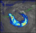
Satellite image from 6:34 AKDT (14:34 UTC) showing the ash plume from Kasatochi. The ash is being transported in a counterclockwise spiral that extends for about 600 miles.
thumbnail
Composite image of AVHRR and located earthquakes, August 7, 2008.

thumbnail
Animation of GOES visible satellite images from August 7, 2008 (click on "full size" link to see animation).
thumbnail
AVHRR image of a volcanic cloud at Kasatochi, August 7, 2008.
Links
How to collect an ash sample for AVO

Please report ashfall to us by email or phone (786-7497). We'd like to know your location, time, if the fall is light or heavy, and the current weather. It would help us if you collect a sample for us. Here are instructions.

Before an eruption
Read the USGS Ashfall Preparedness "Before an eruption" website

Useful Links
Puff ash cloud predictions
Ted Stevens Airport Flight Status (Anchorage)
USGS Ashfall Preparedness website
FEMA Fact Sheet: Volcanoes
FEMA Volcanoes: Are you ready?
Alaska Division of Homeland Security and Emergency Management
Send us an email

Kasatochi Volcano Activity NotificationsRSS Feed
YELLOW/ADVISORY 2008-10-24 11:00:47 - Weekly Update
YELLOW/ADVISORY 2008-10-23 12:13:35 - Status Report
YELLOW/ADVISORY 2008-10-22 12:50:06 - Status Report
YELLOW/ADVISORY 2008-10-21 12:36:59 - Status Report
YELLOW/ADVISORY 2008-10-20 12:29:09 - Status Report
YELLOW/ADVISORY 2008-10-19 13:36:35 - Status Report
YELLOW/ADVISORY 2008-10-18 12:38:39 - Status Report
YELLOW/ADVISORY 2008-10-17 14:34:34 - Weekly Update

More ...

YELLOW/ADVISORY 2008-10-16 13:04:04 - Status Report
YELLOW/ADVISORY 2008-10-15 11:54:34 - Status Report
YELLOW/ADVISORY 2008-10-14 11:26:48 - Status Report
Webicorders
webicorder example
Stations available:
ADAG_EHZ_AV
GSCK_EHZ_AV
NOAA ARL Ash Trajectory Forecasts
trajectory
trajectory
trajectory
trajectory

Click on a picture for a larger image.

These graphics depict a simulation of the direction and speed of potential ash cloud motion from Kasatochi. IF a significant ash cloud were generated by the current eruption. It does not mean that such an ash cloud has been produced. These models are run every 6 hours independent of the current eruptive state of the volcano. Each colored line indicates the direction a cloud would travel at different altitudes (see key below map plot).

Model output by NOAA ARL, please see http://www.arl.noaa.gov/ready/traj_alaska.html for more information.

Kasatochi portion of weekly Updates and periodic Information Releases.
Friday, October 17, 2008 2:34 02:34:34 PM AKDT
Friday, October 10, 2008 1:59 01:59:05 PM AKDT
Friday, October 3, 2008 12:04 12:04:52 PM AKDT

September 2008 Updates
August 2008 Updates


Full version of current Update | Archives
Full version of current Information Release | Archives
URL: http://www.avo.alaska.edu/activity/Kasatochi.php
Contact Information: AVO Web Team