Map of Augustine GPS and Seismic Stations
The backbone of AVO's volcano monitoring program consists of networks of continuously recording seismometers installed at selected volcanoes. Seismic data
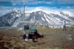
Seismometer installed at Mt. Spurr
are relayed to AVO facilities in Fairbanks and Anchorage where they are analyzed both automatically and by analysts. Initially, AVO concentrated
its monitoring efforts on the four Cook Inlet volcanoes because they are closest to Alaska population centers. In response to the increasing
hazard to aviation from volcanic ash, AVO started a program of expansion in 1996 to other volcanoes in the Aleutian Islands and on the Alaska Peninsula,
and now monitors more than 20 volcanoes. Volcanic unrest, caused by the migration of magma and other fluids through the earth's crust, is
heralded by increased seismicity, often months to weeks before eruption. Because the seismometers provide a continuous data stream the onset of
explosive eruptions can be detected quickly in most cases and appropriate warnings issued. An electronic alarm system is employed during non-business
hours.
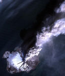
Landsat 5 view of 1986 Augustine eruption.
Satellite imagery provides information which complements seismic monitoring at those volcanoes with seismic networks, and is the only source of routine monitoring
information at those without. AVO analyzes available satellite data twice daily for thermal anomalies and ash plumes at about 80 volcanoes
in the north Pacific. Thermal anomalies at volcanic vents have been detected up to several weeks before large eruptions. Volcanic ash
erupted into the atmosphere is a serious hazard to jet aircraft because it can cause their engines to shut down as it is ingested. By analyzing
satellite imagery and working with the National Weather Service to predict where winds will carry the ash, AVO assists the Federal Aviation Administration
in warning aircraft of areas to avoid.
Space-based deformation monitoring is an emerging technique. AVO operates a network of telemetered GPS receivers at Augustine Volcano, in lower Cook Inlet
that provide a continuous record of ground deformation. AVO also conducts periodic field-based GPS surveys as well as measuring deformation
with satellite radar interferometry (InSAR) techniques. These techniques are providing important information about inflation and deflation of volcanoes,
but are not yet evolved enough for routine real-time monitoring of many volcanoes.
During eruptions and under conditions of heightened concern, the crisis center at AVO-Anchorage becomes directly responsible for all AVO activities concerning
the emergency. AVO is the principal point of contact for information on volcanic activity and hazards assessment for government agencies, the
media, and the public. At all times and especially during volcanic emergencies, AVO maintains close communication links with other critical
agencies such as National Weather Service and Federal Aviation Administration.
AVO's component agencies have a statutory obligation to distribute information regarding volcanic activity in Alaska. Currently, AVO distributes
a weekly summary of volcanic activity in Alaska each Friday. During eruptions, written statements that include the location, time, size of
the eruption, and narrative descriptions of projected plume paths, are distributed by AVO to federal, state, and local government agencies, directly
affected private parties, the media, and commercial airlines by pre-programmed facsimile machines and electronic mail systems. Additional information
releases are prepared as needed, depending on changes in volcanic activity or hazards. AVO also maintains two recorded message lines (numbers)
which are updated frequently with summations of the latest status of volcanic activity. AVO answers many calls from the general public and routinely
gives interviews with media and tours of the AVO facility. AVO staff deliver presentations to schools and other groups as part of a vigorous
outreach and public information program. In an effort to distribute portions of a vast image library of volcanic phenomena, AVO staff periodically
publish video footage and photographs of Alaska's volcanoes.
Information dissemination regarding eruption of Kamchatkan volcanoes is accomplished by close cooperation with the Kamchatka Volcano Event Response Team (KVERT), located in Petropavlovsk-Kamchatsky, Russia.
(last revision October 24, 2000)