Top News of the Day
Watches &
Warnings
Observations Forecast Graphics Rivers &
Lakes
 Climate  Fire Weather
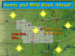
Click on the map below for the latest forecast.
Last map update: Mon, Sep. 15, 2008 at 11:32:36 pm CDT
Read watches, warnings & advisories
National Weather Service Goodland, KS National Weather Service Hastings, NE National Weather Service Topeka, KS
National Weather Service Dodge City, KS
Zoom
Out

National Weather Service Springfield, MO
National Weather Service Norman, OK National Weather Service Tulsa, OK
Flood Warning
Flood Advisory
Hazardous Weather Outlook
Latest Conditions in Wichita - Mid-Continent, KS Choose Your Front Page City
spacer image Sep 15
10:53 pm
Clear. Click for additional data and forecast.
Clear
56°F
(13°C)
spacer image spacer image

Weather Story
Weather Story of the Day - Click to enlarge
Radar
Local Radar for Wichita, Kansas - Click to enlarge
Satellite
Regional Infrared Satellite Image - Click to enlarge
Weather Map
National Weather Map - Click to enlarge
Top Items of the Day

On this Day in Weather History...
In 1982, a snowstorm over Wyoming produced 16.9 inches in Lander to set a 24 hour record for the city in the month of September.
Record Rainfall and Flooding on September 12th! (9/13/2008)
(Archive of all Weather Stories)

Other New Items on our web site


Local Climate Water & Weather Topics:
Current Hazards, Current Conditions, Radar, Satellite,
Climate, Weather Safety, Contact Us

  • NOAA's National Weather Service
  • Wichita, Kansas Weather Forecast Office
  • 2142 S. Tyler Road
  • Wichita, KS 67209-3016
  • 316-942-3102
  • Page Author: ICT Webmaster
  • Web Master's E-mail: w-ict.webmaster@noaa.gov
  • Page last modified: 13-Jul-2007 9:30 PM UTC
USA.gov is the U.S. government's official web portal to all federal, state and local government web resources and services.