|
Current
Products
Short
Range
Medium Range
QPF
Exces.
Rain/
Wint.
Wx
Tropical
Selected
Cities/
Travelers Forecast
Model
Diagnostics
and Biases
Surface
Analysis
Experimental

International
Desks

Questions or Comments About the HPC Website?
Click
here to send mail to the HPC Webmasters.
|
This page is no longer maintained. Please visit the page below and update your bookmarks accordingly:
/html/fam2.shtml
|
|
Product
Information
The following provides technical information
on the HPC for forecasters
and others interested in the details of
HPC operations
|
HPC Mission
The Hydrometeorological Prediction Center (HPC)
provides forecast, guidance, and analysis products and services to support
the daily public forecasting activities of the NWS and its customers, and
provides tailored support to other government agencies in emergency and
special situations.
We are here to assist and be a resource for you.
We are available 24 hours a day, 7 days a week to alert you to the potential
for significant weather events dealing with heavy rainfall or snowfall,
to discuss quantitative precipitation forecasts and model differences relating
to general weather and precipitation forecasts, and to provide forecast
guidance into the medium range period (days 3 to 7). Most of the forecasters
at the HPC have extensive experience at quantitative precipitation, heavy
snow and medium range forecasting.
|
Quantitative Precipitation Forecasts (QPFs)
Forecasters at the HPC [and its predecessor organizations,
NMC's Meteorological Operations Division, Heavy Precipitation Branch (HPB)
and the Quantitative Precipitation Branch (QPB)] have been issuing QPFs
since 1960. All QPFs incorporate the latest surface and upper air analyses,
radar data, satellite data, and model guidance from the Eta, NGM, AVN,
meso-Eta, and RUC displayed on N-AWIPS workstations. The FOB also works
in conjunction with meteorologists in NESDIS's
Synoptic Analysis Branch (SAB) to obtain information regarding satellite
trends, precipitation and moisture availability estimates. This collocation
and collaboration between SAB and HPC is bureaucratically known as the
National Precipitation Prediction Unit (NPPU).
An FOB Senior Branch (lead) Forecaster (SBF) is
on shift at all times. He or she is responsible for producing the 24 hour
precipitation forecasts, coordination of all HPC products (both internally
and with other NWS offices), and center administrative operations after
business hours. In addition to normal duties, the SBF participates in the
East Coast winter storm and NHC hurricane conference calls regarding heavy
precipitation, the NWS PRE-MARD Initiative, occasional unscheduled FEMA
conference calls and numerous media interviews.
|
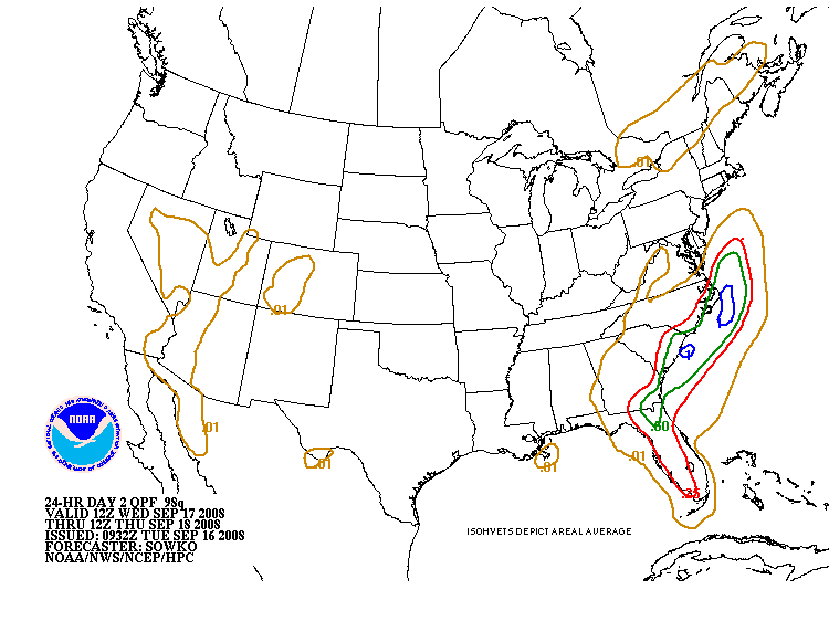
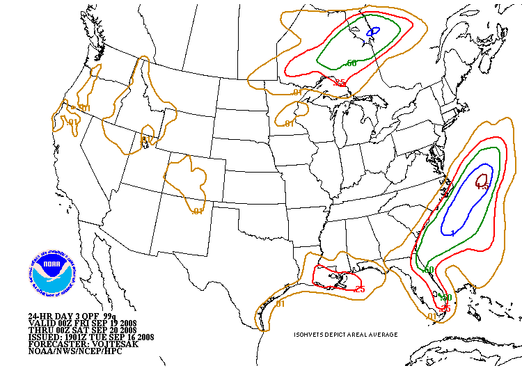
24 Hour QPFs
Isohyets of expected basin average rainfall of
0.01, 0.25 inch, 0.50 inch, 1 inch, and 1.50 inch and greater (in
inch increments) are drawn for the 24 hour forecast period ending at 1200Z
on both days 1, 2, and 3.
An electronically generated bulletin, which describes
the location of the forecast isohyets using latitude and longitude points,
is transmitted at the end of the qpf discussion for the Day 1 through Day
3 finals.
Example:
0.25 350731 349761 349789
347803 340819 327837 310854 297864 284874
0.50 404072 395071 390076
387081 389084 395085 402082 404076 404072
The first field is the value of the contour (in
this case...0.25" or 0.50"). The following fields are the latitude/longitude pairs
for the contour. The first three digits of the pair are the degrees of
latitude (in tenths of degrees North latitude). The last three digits of
the pair are the degrees of longitude (in tenths of degrees West longitude).
If the fourth digit is less than 5, a leading
"1" is added to indicate longitudes greater than or equal to 100° W.
From the above message, the following table gives the decoded lat/long
pairs:
| Value: 0.25" |
Value: 0.50" |
| 35.0N, 73.1W |
40.4N, 107.2W |
| 34.9N, 76.1W |
39.5N, 107.1W |
| 34.9N, 78.9W |
39.0N, 107.6W |
| 34.7N, 80.3W |
38.7N, 108.1W |
| 34.0N, 81.9W |
38.9N, 108.4W |
| 32.7N, 83.7W |
39.5N, 108.5W |
| 31.0N, 85.4W |
40.2N, 108.2W |
| 29.7N, 86.4W |
40.4N, 107.6W |
| 28.4N, 87.4W |
40.4N, 107.2W |
|
|
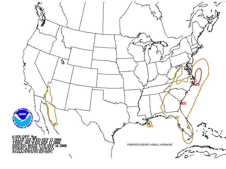
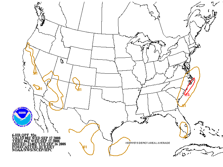
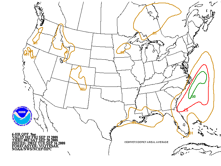
6 Hourly QPFs
| Product |
Valid Period |
Issuance Time |
| 92e,
93e,
9ee, &
9fe
|
12-18Z, 18-00Z,
00-06Z, 06-12Z |
1015Z |
| 9ge,
9he,
9ie, &
9je
|
Same as above but for Day 2 |
1015Z |
| 9ke,
9le,
9oe, &
9ne
|
Same as above but for Day 3 |
1015Z |
| 92e,
93e,
9ee, &
9fe
|
00-06Z, 06-12Z,
12-18Z, 18-00Z |
2215Z |
| 9ge,
9he,
9ie, &
9je
|
Same as above but for Day 2 |
2215Z |
| 9ke,
9le,
9oe, &
9ne
|
Same as above but for Day 3 |
2215Z |
These forecasts depict isohyets of accumulated
precipitation of 0.01, 0.25, 0.50, and 1 inch expected in each six hour
period. The SBF generates the six-hourly forecast for Day 1. The QPF forecaster,
known as the Day 2/3 six-hourly forecaster, generates the Day 2 and Day
3 six hourly products during 2 shifts per day (~9am-5pm/9pm-5am EST), issuing
QPFs for eight consecutive six-hourly periods ending on synoptic hours.
|
Excessive Rainfall Potential
This product outlooks the potential for flash
flooding based on current flash flood guidance issued by RFC's. The graphic
and discussion are issued 3 times a day, at 0615Z, 1430Z, and 1815Z
for the current 24 hour period ending at 12Z. Special rainfall discussions
(NFDQPFSRD) and an updated graphic (94E) are issued after 1930Z if significant
changes to the flash flood outlook are necessary before the next scheduled
issuance time.
Three categories are used to indicate flash
flood threat:
An Exceeding area outlines a geographical
area to the right of a solid arrow drawn using station identifiers as anchor
points where conditions are favorable for rainfall to exceed flash flood
guidance values.
An Approaching area is generally used in
winter-time or for synoptic-scale situations where flash flood guidance
values are relatively high but accumulated precipitation amounts from a
larger scale system may lead to run off problems. It outlines an area with
a dashed arrow and labeled "APCHG".
An Isolated area is mainly intended for
use in the Western U.S. where events tend to be more isolated than over
the rest of the conterminous U.S. It is drawn with a dashed-dotted line
and labeled with "ISOLD".
Other labels on the Excessive Rainfall Graphic:
"SEE FOUS 30/CCCQPFERD" over the area affected
or with an arrow pointing to the general area of concern indicates that
there is not sufficient cause or confidence to draw an area, but that the
QPFERD discussion talks about the situation.
If the forecasters feel that the potential exists
for 5 inches or more within the remainder of the outlook period it is depicted
on the graphic with a hatched area.
If conditions are not favorable or are not expected
to become favorable for flash flooding then "Rainfall Not Expected To Exceed
Flash Flood Guidance" is appended to the graphic.
|
QPF Forecast Verification:
6-hourly precipitation forecasts are verified
using a point (station) method while 24 hour forecasts are verified using
an areal method. Current graphs depicting HPC verification scores are available
on the HPC Verification page. For more details about the verification of HPC precipitation forecasts, read the article by Olson, Junker and Korty in Weather and Forecasting.Volume 10, 1995, pgs. 498-511.
|
Medium Range/Extended (3-7 days)
| Product |
Issuance Time |
| Graphics |
1800Z/1900Z (1400 EST/EDT) |
| Discussion |
1830Z/1930Z (1430 EST/EDT) |
The medium range forecast products include: 1)
surface pressure patterns, circulation centers, and fronts for days 3,
4, and 5 into the future, 2) daily maximum and minimum temperatures and
anomalies for days 3-7, 3) daily precipitation probabilities for days 3-7,
and 4) total 5-day precipitation for days 1 through 5. These products are
issued once per day along with a written discussion. Separate forecasts,
similar to the 5-day mean products, are prepared for Hawaii.
Two meteorologists work this once a day shift.
One produces 4-5 day pressure systems/fronts, 4-5 day precipitation, and
3-5 day POP progs while the other produces the 3-7 day temperature and
6-7 day POP progs. They routinely use output from the MRF, ECMWF, and UKMET
medium range models and also consider the Canadian, the Navy's NOGAPS model,
the MRFX, a semi-operationally run experimental version of the MRF, and
ensembles.
During hurricane season, at 1200 noon EDT, on a daily basis since June
1, 1997, the medium range pressure forecaster participates in a conference
call with the NHC via the Hurricane Hotline to discuss current and potential
tropical activity in the Atlantic and Eastern Pacific oceans and how the
medium range models are handling the situation.
|
Model Diagnostics
Twice per day, the HPC model diagnostic meteorologist prepares the Model
Diagnostic Discussion which consists of three sections:
1)
An evaluation of the analyses of the three primary models (Eta, NGM, AVN)
2)
A review of model trends and biases
3)
A description of model differences and preferences
During the cool season
(Nov 1 - Apr 15), this meteorologist is also primarily responsible for requesting
reconnaissance flights whenever the potential exists for major winter storm
development over the East or Gulf Coast states.
|
Surface Analysis Products
The following chart indicates the approximate issuance and web posting schedule for the HPC Surface Analysis. This product depicts the analysis of synoptic and sub-synoptic/mesoscale surface features including highs, lows, fronts, troughs,
outflow boundaries, squall lines, and drylines. The analysis domain covers most of North America, the Western Atlantic and Eastern Pacific oceans, and the Gulf of Mexico.
| Analysis Time |
Issuance Time |
Web Posting |
| 00Z |
0127Z |
0147Z |
| 03Z |
0430Z |
0450Z |
| 06Z |
0733Z |
0753Z |
| 09Z |
1028Z |
1048Z |
| 12Z |
1329Z |
1349Z |
| 15Z |
1635Z |
1655Z |
| 18Z |
1938Z |
1958Z |
| 21Z |
2230Z |
2250Z |
PLEASE NOTE:
The Pacific Ocean analyses (East and West Pacific)
are prepared by NCEP's Ocean
Prediction Center.
|
Probabilistic Heavy Snow/Icing Forecasts
From mid-September through mid-May the HPC routinely
issues heavy snow/icing outlooks and accompanying discussions for heavy
snow out to 54 hours. They cover two separate 12 hour forecast periods,
06 to 18 hours (93S) and 18 to 30 hours (94S) and a 24 hr period, 30-54
hours (98S). The HPC has decided to modify its current heavy snow guidance
product in an effort to make it more useful to those making decisions based
on this forecast. This is described in the Public Information Statement.
The confidence levels used can be considered comparable to the probability
of occurrence of the forecasted parameter.
Risk Criteria:
LOW - 20% to 30% chance of occurrence
within the outlined area.
MODERATE (MDT) - 31% to 70% chance of
occurrence within the outlined area.
HIGH - greater than 70% of occurrence
within the outlined area.
At times the forecasters may use only one or two
isolines for the forecast. This simply implies low or low to moderate forecaster
confidence in the occurrence of the forecasted parameter. One should expect
the confidence to lower as the forecast is extended out in time. To gain
further insight into this forecast, please read the Heavy Snow/Icing Discussion
(HSD) that accompanies this graphical product.
|
Short Range Forecasts (1-2 days)
The "Basic Weather" forecaster is responsible
for preparing the 12, 18, 24, 30, 36 and 48 hour surface progs (forecasts).
These progs are issued twice a day based on output from the 00Z and 12Z
model runs. Emphasis is placed on the subjective modification of numerical
guidance, especially with regard to timing and placement of coded fronts,
high and low pressure systems, and instantaneous precipitation (coverage
and type). The primary aim is to accurately depict the evolution of major
weather systems that will affect the continental U.S. during the next two
(2) days.
* Please note that the transmission
space limits the NFDPMDSPD narrative to 40 lines, thus this message is
necessarily short and sometimes may not discuss significant weather conditions
over the entire continental U.S. in detail and may not be able get into
as much technical detail as users may like.
|
|
Selected Cities/Travler's
The Selected Cities Summary is a highly visible
product that is issued two times per day at 0100 and 1300 UTC. It includes
a tabular array of the previous day's maximum and minimum temperatures
along with temperature and weather forecast for the next two days. The
Selected Cities Summary covers 158 cities in the United States, Puerto
Rico, and the Virgin Islands. It is composed of four parts with the last
part including the observed maximum and minimum temperatures from around
the nation. Forecast data is obtained from your CCFs.
The Travelers Forecast Bulletin is an abbreviated
version of the Selected Cities Bulletin. The Travelers Forecast, like
the Selected Cities is transmitted two times per day, one hour before the
Selected Cities, for thirty (30) cities in the U.S. The Travelers Forecast
consists of three parts which contain the weather and high and low temperature
forecasts extracted from your CCFs.
|
Other HPC Products
Storm Summaries:
AFOS NFDSCCNSS ***
Storm Summaries are issued by the HPC after any
named tropical or sub-tropical cyclone has moved inland and public advisories
are no longer issued by the National Hurricane Center (NHC). In addition,
storm summaries are issued for any major winter storms that produce widespread
snow or ice. The Storm Summaries will continue to be issued as long
as there is a threat of severe weather or flash flooding from the storm
or its remnants. They are numbered sequentially (continuing from the last
numbered advisory issued on the storm by the NHC for tropical systems).
Storm Summaries are transmitted four times a day at or before 0300Z, 0900Z,
1500Z, and 2100Z.
|

If you have any questions or comments about these or any of our products,
we would like to hear from you.
Click here to send mail to the HPC.
|
HPC HOME
What's
New
About
the HPC
HPC
Accomplishments
Product
Information
HPC
Verification
Research
Office
and Staff
Photo
Gallery
Other
Sites
Other
NCEP Centers:
Disclaimer
Please
Read!

Last Updated
November 14, 2001
|


