 |
||||
|
|
|
|||


|
|
Home > Research by Programs > EOS
Environmental Observing Systems
Task Leader: Steve Ruberg
Highlights
Real-time Environmental Coastal Observations Network (RECON): Real-time Data 
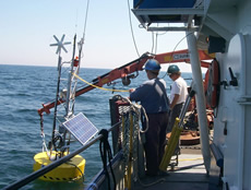
The goal of the RECON project is to develop a national network of low cost coastal buoys capable of seabed to sea-surface observations. The RECON system currently in place in the Great Lakes has national and regional applications. This wireless Internet observation system, with shore stations at four coastal locations covering approximately 800 square miles of sea surface, uses commercially available networking equipment allowing straightforward integration into a nationwide network. Each system collects meteorological data and provides sub-surface measurements of chemical, biological, and physical parameters. The system is designed to allow controlled access to multi-institutional users through surface buoys and sub-surface sensor guest ports located on an underwater hub. The observation network currently provides environmental data to state, federal, and university researchers, educators and resource managers.
+ View Data
+ Read more
International Field Years on Lake Erie (IFYLE)
NOAA GLERL is leading a large scale collaborative research
effort on Lake Erie
+ Read more
CoastWatch Great Lakes and NOAA Ocean Communications Network
![]() CoastWatch is a nationwide National Oceanic and Atmospheric Administration
program. The NOAA Great Lakes Environmental Research Laboratory functions
as the Great Lakes regional node. GLERL is currently receiving an enhanced
digital image product suite of 28 images including satellite-derived
surface temperature, visible and near-infrared reflectance, brightness
temperatures, cloud masks, and satellite/solar zenith angle data from
the NOAA/AVHRR (Advanced Very High Resolution Radiometer) series of
satellites as well as GOES (Geostationary Operational Environmental
Satellites) visible, near infrared, and water vapor data.
CoastWatch is a nationwide National Oceanic and Atmospheric Administration
program. The NOAA Great Lakes Environmental Research Laboratory functions
as the Great Lakes regional node. GLERL is currently receiving an enhanced
digital image product suite of 28 images including satellite-derived
surface temperature, visible and near-infrared reflectance, brightness
temperatures, cloud masks, and satellite/solar zenith angle data from
the NOAA/AVHRR (Advanced Very High Resolution Radiometer) series of
satellites as well as GOES (Geostationary Operational Environmental
Satellites) visible, near infrared, and water vapor data.
+ Read more
Current Featured Projects
(Full List of GLERL Environmental Observing Systems Program Projects)
 Development of Integrated Environmental Observing Systems for
the Great Lakes
Development of Integrated Environmental Observing Systems for
the Great Lakes
This project brings together a team of NOAA and Great Lakes institutes
to construct experimental, integrated environmental observing systems.
The integrated environmental observatory prototype will be capable of
providing real-time observations of chemical, biological, and physical
parameters. The system will include a high bandwidth data link and an
underwater hub designed to allow expansion via satellite nodes. The system
architecture will be designed to allow simple integration of sensors from
various institutions through guest ports.
+ Read more
 Thermal Structure
Monitoring and Related Studies
Thermal Structure
Monitoring and Related Studies
The purpose of this project is to develop improved climatological information
through 1.) observations; 2.) new instrumentation; 3.) improved analyses
of the distribution and variability of coastal and offshore temperatures;
and 4.) by studying their dependence on meteorological and hydrological
forces, with emphasis on potential changes in climate. These studies provide
data for improving numerical models that can simulate and predict the
thermal structure in the lakes, as well.
+ Read more
Data products
Great Lakes Surface Environmental Analysis (GLSEA)
A digital map of the Great Lakes surface water temperature and ice cover
which is produced daily at the NOAA Great Lakes Environmental Research
Laboratory (GLERL) in Ann Arbor, Michigan through the NOAA CoastWatch
program. The GLSEA is stored as a 512x512 pixel map in GIF format, suitable
for viewing on PCs and workstations with readily available software.
+ Read more
NOAA Great Lakes CoastWatch Current Visible Reflectance Products
Great Lakes CoastWatch visible reflectance products are produced using
two types of Advanced Very High Resolution Radiometer (AVHRR) satellite
data. AVHRR channel 2 (reflected infrared at frequency 0.725-1.0 µm)
and channel 1 (visible light at frequency 0.58-0.68 µm) from daytime
passes of NOAA polar orbiting satellites are used to produce this data,
which is useful in the detection of suspended solids and algal blooms
in the Great Lakes.
+ Read more
The Great Lakes Operational Forecasting System
The Great Lakes Operational Forecast System (GLOFS) is a NOAA automated
model-based prediction system aimed at providing improved predictions
(guidance) of water levels, water currents and water temperatures in the
5 Great Lakes (Erie, Michigan, Superior, Huron and Ontario) for the commercial,
recreation, and emergency response communities. GLOFS generates hourly
nowcast guidance (analyses) and four times daily forecast guidance (out
to 30 hours) of total water level, current speed and direction, and water
temperature for each of the Great Lakes. The GLOFS predictions will enable
users to increase the margin of safety and maximize the efficiency of
commerce throughout the Great Lakes.
GLOFS uses as its hydrodynamic model, a version of the Princeton Ocean Model (POM), a sigma coordinate (vertical), curvilinear coordinate (horizontal), free surface, ocean model, which includes a turbulence sub-model. POM was developed in the late 1970's by Dr. Alan Blumberg and Dr. George Mellor, with subsequent contributions from numerous other researchers. The model has been used for modeling of estuaries, coastal regions, basin and global oceans. The present version of POM used by GLOFS has been adapted to the Great Lakes in work led by Dr. David Schwab at NOAA's Great Lakes Environmental Research Laboratory (GLERL) and researchers at The Ohio State University.
+ Great Lakes Operational Forecast System (This link goes to the GLOFS web site)
LANG, G. A. and D. J. SCHWAB. Episodic Events: Great Lakes Experiment
Data Archive. NOAA, Great Lakes Environmental Research Laboratory, Ann
Arbor, MI, 2 CD-ROM Set (2003).
Complete Listing of GLERL Data Products
Program Background
Rapid advancements in remote sensing, the miniaturization of sensors, and other unmanned technologies have vastly increased the data generating capabilities of the scientific community. The goal of GLERL's Environmental Observing Systems research program is to advance our understanding of the effects of biological, chemical, physical, and human-induced changes on ecosystems and to provide useful predictive tools for the public and resource managers.
Recent Publications
Biddanda, B.A., D.F. Coleman, T.H. JOHENGEN, S.A. RUBERG, G.A. Meadows, H.W. VanSumeren, R.R. Rediske, and S.T. Kendall. Exploration of a submerged sinkhole ecosystem in Lake Huron. /Ecosystems/ (online publication) 23 pp. (2006).
+ download file [html]
+ download article [pdf]
HAWLEY, N., T.H. JOHENGEN, Y.R. Rao, S.A. RUBERG, D. BELETSKY, S.A. LUDSIN, B.J.
EADIE, D.J. SCHWAB, T.E. CROLEY II, and S.B. BRANDT. Lake Erie hypoxia prompts
Canada-U.S. study. /Eos Transactions/ 86(32):313-319 (2006).
+
download article [pdf ]
Lee, C.-H., D. J. SCHWAB, and N. HAWLEY. Sensitivity analysis of sediment
resuspension parameters in coastal area of southern Lake Michigan. Journal
of Geophysical Research 110(C03004):16 (2005).
+ download file [pdf]
Plattner, S., D. M. MASON, G. A. LESHKEVICH, D. J. SCHWAB, and E. S. Rutherford. Classifying and forecasting coastal upwellings in Lake Michigan using satellite derived temperature images and buoy data. Journal of Great Lakes Research 32:63-76 (2006).
+ download article [pdf]
Complete list of GLERL Publications
Selected Brochures
NOAA CoastWatch Program in the Great Lakes (PDF)
Meteorological Stations and Web Cams (PDF)
Selected projects of GLERL's Marine Instrumentation Laboratory (PDF)