Tropical Cyclone Report
Hurricane Lili
21 September - 04 October 2002
Miles B. Lawrence
National Hurricane Center
20 December 2002
Revised: 3 April 2003
Hurricane Lili crossed western Cuba as a category two
hurricane on the Saffir-Simpson Hurricane Scale and made landfall
on the Louisiana coast as a category one hurricane. Lili also
affected the Windward Islands as a tropical storm, the northeastern
Cayman Islands as a category one hurricane and caused serious
rainfall flooding in Jamaica. Thirteen deaths are attributed to
Lili. Lili reached category four intensity over the Gulf of
Mexico.
a. Synoptic History
Lili originated from a tropical wave that moved over the
tropical Atlantic Ocean from the west coast of Africa on September
16th. The wave developed a low -level cloud circulation
center midway between Africa and the Lesser Antilles on the
20th. Convective clouds became sufficiently well
organized on the 21st to qualify the system as a
tropical depression, centered about 900 n mi east of the Windward
Islands. The "best track" of the tropical cyclone's path starts at
this stage and is shown in Figure 1. Graphs of best-track maximum
one-minute surface wind speed and minimum central surface pressure,
as a function of time, are shown in
Figure 2 and Figure 3, respectively.
The six-hour best track positions and intensities are listed in
Table 1.
Lili's track followed the pressure contours of the southern and
western periphery of the semi-permanent Atlantic subtropical high
pressure ridge. The tropical cyclone moved just north of due
westward at over 20 knots, crossed the Windward Islands as a
developing tropical storm on the 23rd and then its winds
briefly reached 60 knots on the 24th. The storm weakened
to an open tropical wave on the 25th and 26th
in the east-central Caribbean as its organization was disrupted by
vertical wind shear.
Lili re-acquired a low-level closed circulation on the
27th, then its forward speed slowed to about 5 knots by
the 28th while beginning a slow northward jog around the
north coast of Jamaica. The storm dumped heavy rain on Jamaica and
also Haiti. Resuming a west-northwestward track, Lili became a
hurricane on the 30th, while passing over Cayman Brac
and Little Cayman Islands.
The center of the hurricane moved over the southwest tip of the
Isle of Youth on the morning of October 1st , and over
western mainland Cuba a few hours later, with wind speeds as high
as 90 knots. Gradually accelerating its forward speed to about 15
knots, Lily turned northward and made landfall on the Louisiana
coast on the 3rd, with an estimated 80-knot maximum wind
speed. However, between Cuba and Louisiana, Lili intensified to 125
knots early on the 3rd over the north-central Gulf of
Mexico and then rapidly weakened to 80 knots during the 13 hours
until landfall. Lili was absorbed by an extratropical low on the
4th while moving northeastward near the
Tennessee/Arkansas border. Lili was the first hurricane to make
landfall in the United States since Irene hit Florida in 1999.
b. Meteorological Statistics
Observations used to estimate wind speed and pressure are
plotted in Figure 2 and Figure 3,
along with the best-track wind speed and
pressure curves. These observations include satellite-based Dvorak
technique intensity estimates from the Tropical Analysis and
Forecast Branch (TAFB), the Satellite Analysis Branch (SAB) and the
U. S. Air Force Weather Agency (AFWA), as well as flight-level and
selected dropwindsonde observations from flights of the
53rd Weather Reconnaissance Squadron of the USAF Reserve
Command and from the NOAA Aircraft Operations Center.
Ship reports of winds of tropical storm force or higher are
given in Table 2, and selected surface observations from land
stations and data buoys are given in Table 3.
Sustained wind speeds were near 45 to 50 knots as Lili moved
quickly across the Windward Islands. A sustained wind speed of 47
knots with a gust to 68 knots was observed at Martinique early on
the 24th.
The forward motion slowed to five knots as Lili moved between
Haiti, Jamaica and eastern Cuba. This slow motion contributed to
the copious rainfall over Jamaica from the 27th through
the 30th, where over 20 inches of rainfall was recorded
(Table 3). Haiti also received considerable rainfall.
Lili developed an eye which passed over the Isle of Youth and
then western mainland Cuba on October 1st. The highest
wind report from Cuba was a ten-minute average of 87 knots with a
gust to 98 knots from Francia on the Isle of Youth and this is the
basis for a best-track wind speed of 90 knots over Cuba. The
highest aircraft -measured flight-level wind speed during this time
was 87 knots. Over six inches of rainfall was recorded at locations
in Granma and Santiago de Cuba provinces in eastern Cuba.
The highest best-track wind speed is estimated at 125 knots at
0000 UTC on the 3rd, while the hurricane was centered in
the north-central Gulf of Mexico. This is based on an aircraft
700-mb flight-level wind speed of 142 knots along with 938-mb
surface pressure. The aircraft flight level-wind speed reduces to a
surface wind of 128 knots using a 90 percent eyewall reduction
factor. There were also several GPS-sonde surface wind speed
measurements of 115 to 123 knots near this time. The east eye wall
passed over NOAA data buoy 42001 at 2000 UTC on the 2nd.
This buoy reported a ten-minute wind speed of 98 knots with a gust
to 130 knots, which is the highest wind speed ever recorded by a
National Data Buoy Center buoy.
Hurricane Lili made landfall along the south-central coast of
Louisiana near Intracoastal City. The highest observed sustained
wind over land is 64 knots (Table 3), from a Texas Tech. tower near
Kaplan or about 15 n mi north-northwest of Intracoastal City. The
highest recorded wind gust is 104 knots at Intracoastal City. The
highest aircraft flight level wind speed near the time of landfall
is 88 knots at 700 mb. The highest surface wind speed estimate
obtained from GPS-sondes during the last few hours before landfall
is 73 knots. A mobile SMART radar measured 101 knots just above the
surface south of New Iberia. The lowest surface pressure observed
was 963.9 mb at the Louisiana Agriclimate Information System at
Crowley. Based on the above data, the best-track maximum wind speed
at landfall is estimated at 80 knots. The landfall area is sparsely
populated. Most of southern Louisiana experienced sustained winds
of 65 knots or less.
Lili's eyewall collapsed as its wind speed decreased during the
13 hours before landfall. The radius of maximum wind speed may not
have been close to the center at landfall. Aircraft Flight level
winds near the coast just south of Morgan City suggest that the
highest winds were perhaps 50 n mi east of the center, so that wind
speeds near the coast south of Morgan City could have been as high
or higher than wind speeds near Intracoastal City, where the center
crossed the coast.
Rainfall across south-central and southeastern Louisiana ranged
from four to eight inches, with the highest amount of 8.57 inches
at Perry, just north of Intracoastal City. Over four inches was
measured in northern Louisiana and southern Mississippi and over
two inches spread into Arkansas. Portions of Florida and Alabama
had over an inch of rain. A tide gage at Crewboat Channel near
Calumet measured a storm tide water height of 12.3 feet and another
at Vermillion Bay measured 11.7 feet. The water height at Burn's
Point, south of Morgan City, is estimated at 10 to 12 feet above
normal, based on the observed water level inside a house. A
combination of storm surge and heavy rain caused levees to fail at
Montegut and Franklin, Louisiana. Tide gauge waters levels were
already 2 to 4 ft above normal prior to Lili's arrival.
Tornadoes were reported in Acadia, Evangeline, Lafayette,
Rapides, and St. Landry Parishes. Most were short-lived and damage
was in the F-0 to F-1 range on the Fujita scale.
c. Casualty and Damage Statistics
Lili went through the Windward Islands as a tropical storm.
Landslides killed four in St. Vincent, including an infant. There
was damage to 400 homes in Barbados and half the banana crop of St.
Lucia was destroyed.
Jamaica was hard hit by heavy rain from Lili. Four people,
including a 3-year-old child, died when flood waters swept them
away. Flood waters also swept away livestock and crops and caused
extensive damage to homes, bridges, roadways, and other
infrastructure. Flood damage was compounded by heavy rain earlier
in September from Hurricane Isidore. This is also the case with
rainfall over western Cuba and Louisiana. Lili also pelted Haiti's
south coast with wind and rain and four flood-related deaths
occurred there.
There are news reports of high winds uprooting trees, knocking
out electricity and damaging roofs in Cayman Brac in the
northeastern Cayman Islands.
The hurricane cut a swath of destruction across western Cuba,
damaging buildings and farmland and disrupting communications. Some
360,000 people were reported to have been evacuated from their
homes. There was one direct death in Pinar del Rio province.
Lili made landfall on the central Louisiana coast as a category
one hurricane and left behind a trail of muck and misery from
widespread wind and flood damage. Strong winds toppled trees onto
houses and into roadways, stripped shingles from roofs, and blew
out windows. The wind and driving rain flattened sugar cane fields
throughout southern Louisiana. A combination of storm surge and
rain caused levees to fail in the southeastern part of the state.
Lili also temporarily curtailed all oil production in the Gulf of
Mexico. The latest insured property damage total from the American
Insurance Services Group is $430 million U.S. dollars, $415 million
for Louisiana and &15 million for Mississippi. The total dollar
damage estimate is twice this value or $860 million dollars.
President Bush declared that Louisiana is eligible for federal
assistance.
One indirect fatality occurred in Crowley, Louisiana, when an
elderly woman died from carbon monoxide poisoning from a generator.
Another indirect fatality occurred in Vermilion Parish where a 79
year old Erath man died when he fell from a ladder cleaning up
storm debris.
d. Forecast and Warning Critique
Table 4 is a listing of average errors (with the number of cases
in parentheses) for official forecasts and for a selection of
guidance models. The official track errors are between 30 and 48
percent lower than the average official track errors for the
previous 10-yr period, also listed in Table 4. The GUNS and GUNA
guidance consistently had smaller errors than the official forecast
at all forecast periods. These two guidance models are
equally-weighted combinations of the GFDI, UKMI, and NGPI models
(GUNS) and of GFDI, UKMI, NGPI, and AVNI models (GUNA).
Average official intensity errors are near the previous 10-yr
averages and are smaller than all of the guidance errors.
Table 5 lists the watches and warnings issued for Lili. The
hurricane made landfall on the Isle of Youth, Cuba 20 h after
hurricane warnings were issued and made landfall on the western
Cuba mainland 23 hours after warnings were issued. Hurricane
warnings were issued for coastal Louisiana 28 h before
landfall.
Table 1: Best track for Hurricane Lili,
21 September - 4 October 2002. Positions and pressures during the
tropical wave stage are representative of the low-level vorticity
center.
Date/Time
(UTC) | Position | Pressure
(mb) | Wind Speed
(kt) | Stage |
Lat.
(°N) | Lon.
(°W) |
| 21 / 1800 | 10.2 | 44.6 | 1009 | 25 | tropical depression |
| 22 / 0000 | 10.3 | 46.5 | 1007 | 30 | " |
| 22 / 0600 | 10.8 | 48.5 | 1006 | 30 | " |
| 22 / 1200 | 11.2 | 50.4 | 1006 | 30 | " |
| 22 / 1800 | 11.8 | 52.2 | 1005 | 30 | " |
| 23 / 0000 | 12.1 | 54.6 | 1005 | 35 | tropical storm |
| 23 / 0600 | 12.2 | 56.8 | 1005 | 40 | " |
| 23 / 1200 | 12.4 | 58.7 | 1004 | 45 | " |
| 23 / 1800 | 12.5 | 60.4 | 1005 | 50 | " |
| 24 / 0000 | 12.7 | 62.1 | 1006 | 50 | " |
| 24 / 0600 | 12.8 | 63.7 | 1006 | 50 | " |
| 24 / 1200 | 13.0 | 64.9 | 1004 | 60 | " |
| 24 / 1800 | 13.2 | 66.0 | 1007 | 50 | " |
| 25 / 0000 | 13.5 | 66.9 | 1008 | 35 | " |
| 25 / 0600 | 13.7 | 67.5 | 1008 | 35 | " |
| 25 / 1200 | 14.0 | 68.2 | 1008 | 40 | tropical wave |
| 25 / 1800 | 14.2 | 68.9 | 1007 | 40 | " |
| 26 / 0000 | 14.5 | 69.8 | 1007 | 35 | " |
| 26 / 0600 | 14.9 | 71.0 | 1007 | 35 | " |
| 26 / 1200 | 15.3 | 72.2 | 1007 | 30 | " |
| 26 / 1800 | 15.6 | 73.0 | 1006 | 30 | " |
| 27 / 0000 | 15.7 | 73.5 | 1006 | 30 | tropical depression |
| 27 / 0600 | 15.9 | 74.0 | 1006 | 30 | " |
| 27 / 1200 | 16.1 | 74.6 | 1003 | 35 | tropical storm |
| 27 / 1800 | 16.7 | 75.0 | 1004 | 40 | " |
| 28 / 0000 | 17.4 | 75.1 | 999 | 45 | " |
| 28 / 0600 | 17.5 | 75.6 | 999 | 45 | " |
| 28 / 1200 | 18.1 | 75.4 | 1002 | 45 | " |
| 28 / 1800 | 18.5 | 75.7 | 1003 | 45 | " |
| 29 / 0000 | 18.8 | 76.1 | 1001 | 45 | tropical storm |
| 29 / 0600 | 18.8 | 76.8 | 999 | 40 | " |
| 29 / 1200 | 18.7 | 77.2 | 994 | 45 | " |
| 29 / 1800 | 18.7 | 77.6 | 994 | 50 | " |
| 30 / 0000 | 19.0 | 78.1 | 993 | 55 | " |
| 30 / 0600 | 19.1 | 78.7 | 990 | 60 | " |
| 30 / 1200 | 19.6 | 79.6 | 986 | 65 | hurricane |
| 30 / 1800 | 20.0 | 80.3 | 984 | 65 | " |
| 01 / 0000 | 20.5 | 81.1 | 978 | 70 | " |
| 01 / 0600 | 21.0 | 82.2 | 970 | 75 | " |
| 01 / 1200 | 21.6 | 83.2 | 971 | 90 | " |
| 01 / 1800 | 22.4 | 84.4 | 971 | 90 | " |
| 02 / 0000 | 23.0 | 85.7 | 967 | 90 | " |
| 02 / 0600 | 23.6 | 87.2 | 954 | 100 | " |
| 02 / 1200 | 24.4 | 88.3 | 954 | 110 | " |
| 02 / 1800 | 25.4 | 89.5 | 941 | 120 | " |
| 03 / 0000 | 26.7 | 90.3 | 940 | 125 | " |
| 03 / 0600 | 28.1 | 91.4 | 957 | 105 | " |
| 03 / 1200 | 29.2 | 92.1 | 962 | 80 | " |
| 03 / 1800 | 30.5 | 92.4 | 976 | 60 | tropical storm |
| 04 / 0000 | 31.9 | 92.1 | 985 | 40 | " |
| 04 / 0600 | 33.5 | 91.4 | 994 | 30 | tropical depression |
| 04 / 1200 | 35.8 | 90.0 | 997 | 25 | " |
| 04 / 1800 | | | | | absorbed by extratropical low |
| 02 / 2013 | 25.9 | 89.9 | 938 | 125 | minimum pressure |
| 30 / 1400 | 19.7 | 79.8 | 986 | 65 | landfall-Little Cayman and Cayman Brac |
| 01 / 1100 | 21.3 | 83.0 | 971 | 90 | landfall-Isle of Youth, Cuba |
| 01 / 1400 | 22.1 | 84.0 | 971 | 90 | landfall-Pinar del Rio Province,Cuba |
| 03 / 1300 | 29.5 | 92.2 | 963 | 80 | landfall-near Intracoastal City, LA |
Table 2: Selected ship reports with winds of at least 34 kt for
Hurricane Lili, 21 September - 4 October 2002.
| Ship Name or Call Sign | Date/Time (UTC) | Lat.
(°N) | Lon.
(°W) | Wind dir/speed (deg/kt) | Pressure (mb) |
| 3FOB5 | 24 / 1200 | 17.0 | 68.5 | 100 / 45 | 1015.0 |
| DEFL | 28 / 1200 | 19.4 | 74.3 | 110 / 73 | 1008.7 |
| KAFO | 01 / 1800 | 24.4 | 82.2 | 120 / 39 | 1012.1 |
| KRNJ | 02 / 0300 | 24.7 | 84.1 | 100 / 38 | 1010.0 |
| KSPH | 02 / 1200 | 23.8 | 86.8 | 180 / 36 | 1005.2 |
| ELYN2 | 02 / 1500 | 21.0 | 85.6 | *** / 82 | 1014.5 |
| KSPH | 02 / 1500 | 24.2 | 87.3 | 160 / 35 | 1007.2 |
| KSPH | 02 / 1800 | 24.7 | 87.8 | 170 / 40 | 1007.1 |
| KSPH | 02 / 2100 | 24.6 | 87.9 | 180 / 35 | 1006.8 |
| KSPH | 03 / 0300 | 25.4 | 89.1 | 180 / 35 | 1008.2 |
| WGXO | 03 / 0300 | 29.0 | 88.5 | 100 / 41 | 1009.2 |
| KSPH | 03 / 0600 | 25.7 | 89.6 | 180 / 35 | 1007.2 |
| WGXO | 03 / 0600 | 28.8 | 88.0 | 110 / 39 | 1009.5 |
| KSPH | 03 / 0900 | 26.1 | 90.2 | 190 / 35 | 1006.0 |
| WGXO | 03 / 0900 | 28.6 | 87.4 | 120 / 36 | 1009.1 |
| KSPH | 03 / 1500 | 27.0 | 91.4 | 240 / 35 | 1007.9 |
| WGXO | 03 / 1500 | 28.0 | 88.7 | 170 / 36 | 1010.2 |
| WZJE | 03 / 1500 | 28.3 | 93.0 | 300 / 37 | 1003.0 |
| KSPH | 03 / 1800 | 27.3 | 91.9 | 240 / 35 | 1007.2 |
|
Table 3: Selected surface observations
for Hurricane Lili, 21 September - 4 October 2002.
| | Minimum
Sea-level
Pressure | Maximum Surface Wind Speed
(kt) | |
| Location | Date/
Time
(UTC) | Press.
(mb) | Date/
Timea
(UTC) | Sust.
Windb
(kts) | Peak
Gust (kts) | Storm
Surgec
(ft) | Storm
Tided
(ft) | Rain
(storm total)
(in) |
| Louisiana |
| Alexandria int. airport | 03/2141 | 980.4 | 02/2054 | 33 | 52 | | | 4.14 |
| Baton Rouge | 03/2353 | 997.0 | 03/1717 | | 41 | | | |
| Belle Chase | | | 03/0855 | | 44 | | | |
| Boothville | 03/0957 | 1005.4 | 03/1732 | 34 | 43 | | | 7.19 |
| Burns Point/Salt Point | | | | | | | 10-12 | |
| Buras | | | | | | | | 8.40 |
| Cajun field, Lafayette | | | 03/1636 | 41 | 66 | | | |
| Castille Pass nr Morgan City | | | | | | | 10.6 | |
| Cocodrie, Terrebonne Parish | | | | | | | 9.94 | |
| Cote Blanch Is.(Tex. Tech.) | | | 03/1406 | 52 | 79 | | | |
| Crewboat Ch. Nr Calumet | | | | | | | 12.3 | |
| CSI-03 (29.44N 92.06W) | | | | 63 | | | | |
| Cypremort Point | | | | | 88 | | | |
| Dean Lee(Alexandria) | | | 03/1810 | 43 | 58 | | | |
| Delcambre, Route 14 | 03/1514 | 977.7 | 03/1508 | 54 | 84 | | 2 | |
| Frenier causeway | | | 03/0910 | 34 | 46 | | | |
| Grand Isle | | | | | | | 4.46 | |
| Iberia (Jeanerertte) | | | 03/1416 | 46 | 59 | | | |
| Intracoastal City | | | | | 104 | | 6 | |
| Jennings | | | | | 77 | | | 3.91 |
| Kaplan(Tex. Tech tower) | 03/1524 | 965.7 | 03/1438 | 64 | 86 | | | |
| Lafayette reg. airport | 03/1623 | 983.1 | 03/1559 | 47 | 63 | | | 4.54 |
| L. Bourne Bayou Dupre | | | | | | | 6.58 | |
| Lake Charles reg. airport | 03/1641 | 993.9 | 03/1604 | 31 | 41 | | | 2.47 |
| L. Pontchartrain LUMCON | 03/2012 | 1001.9 | 03/1034 | 51 | 60 | | | |
| L. Pontchartrain mid cswy. | | | 03/1020 | 50 | 60 | | | |
| L. Pontchartrain RIGL1 | | | | | | | 6.04 | |
| LUMCON consortium hq. | 03/1024 | 997.7 | 03/1231 | 43 | 54 | | | |
| Mandeville causeway | | | 03/1640 | 36 | 48 | | | |
| New Iberia (29.91N 91.76W) | | | 03/1542 | 54 | 72 | | | |
| N. Orl. int. airport | 03/1159 | 1004.1 | 03/1617 | 34 | 44 | | | |
| N. Orl. Lakefront airport | 03/0943 | 1003.4 | 03/1002 | 39 | 47 | | | |
| Perry | | | | | | | | 8.57 |
| Rice (Crowly) | 03/1543 | 963.9 | 03/1528 | 47 | 61 | | | |
| Terrebone Bay LUMCON | 03/1029 | 995.8 | 03/0553 | 50 | 59 | | | |
| Vermilion bay/B. Fearman | | | | | | | 11.7 | |
| | | | | | | | |
| Other States |
| Beaumont, TX
reg. airport | 03/1911 | 1001.4 | 03/1548 | 27 | 32 | | 5.40 | |
| Burkeville, Texas | | | | | | | | 0.94 |
| Point Cadet, Mississippi | | | | | | | | |
| Picayune, Mississippi | | | | | | | | 4.14 |
| Connerly Bayou, Arkansas | | | | | | | | 4.34 |
| Chicago-Midway, Illinois | | | | | | | | 1.04 |
| Bloomington, Indiana | | | | | | | | 0.85 |
| Padukah/Barkley, Kentucky | | | | | | | | 0.91 |
| Cincinnati-Luken, Ohio | | | | | | | | 0.59 |
| Pensacola, Florida | | | | | | | | 1.04 |
| Fairhope, Alabama | | | | | | | | 1.20 |
| NOAA buoy and Cman |
| 42001 | | | 02/2010 | 98 | 130 | | | |
| 42003 | 02/0800 | 1009.0 | 02/0720 | 36 | 49 | | | |
| 42007 | | | 03/1140 | 36 | 47 | | | |
| 42041 | 03/0300 | 984.0 | 03/0220 | 56 | 70 | | | |
| BURL1 | | | 03/1020 | 52 | 70 | | | |
| DRYF1 | 01/0810 | 1010.8 | 01/1714 | | 46 | | | |
| DPIA1 | 03/1559 | 1010.5 | 03/1559 | 31 | 35 | | | |
| GDIL1 | | | 03/0640 | 36 | 69 | | | |
| Jamaica |
| Cedar Valley in St. Thomas | | | | | | | | 23.11 |
| Craighead in Manchester | | | | | | | | 20.26 |
| Knock Patrick in Manchester | | | | | | | | 21.66 |
| Shewsbury in Westmoreland | | | | | | | | 23.82 |
| Sunny Hill in St. Thomas | | | | | | | | 22.06 |
| Cuba |
| Francia | 01/1100 | 991.2 | 01/1120 | 87 | 98 | | | |
| Isabel Rubio | 01/1550 | 971.4 | 01/1625 | 43 | 63 | | | |
| Matias, Santiago de Cuba | | | | | | | | 6.22 |
| Pilon, Granma | | | | | | | | 6.20 |
| Pinar del Rio | 01/1500 | 990.0 | 01/1450 | 59 | 76 | | | |
| Punta del Esta | 01/0905 | 989.7 | 01/1030 | 77 | 93 | | | |
| San Juan y Martinez | 01/1550 | 981.4 | | 72 | 88 | | | |
| Other Islands |
| Morne des Cadets, Martinique | | | 24/0300 | 47 | 68 | | | |
| Pt. Salines, Grenada | 24/0700 | 1006 | 24/0800 | 40 | | | | |
| Grantley Adams, Barbados | | | 23/1700 | 41 | 65 | | | |
| Hewanorra, St. Lucia | | | 23/2100 | 35 | 47 | | | |
aDate/time is for wind gust when both sustained and gust are listed.
bExcept as noted, sustained wind averaging periods for C-MAN and land-based ASOS reports are
2 min; buoy averaging periods are 8 min.
cStorm surge is water height above normal astronomical tide level.
dStorm tide is water height above National Geodetic Vertical Datum (1929 mean sea level). |
Table 4: Official and selected model forecast errors for
Hurricane Lili,2002. Errors are for tropical storm and hurricane
stages and are followed by the number of forecast cases in
parentheses. Errors smaller than official forecast errors are shown
in bold-face type.
| Forecast Technique | Period (hours) |
| 12 | 24 | 36 | 48 | 72 |
| CLP5 | 38 (33) | 87 (29) | 142 (25) | 213 (21) | 341 (19) |
| GFDI | 30 (33) | 51 (29) | 72 (25) | 89 (21) | 178 (19) |
| LBAR | 33 (33) | 58 (29) | 76 (25) | 84 (21) | 124 (19) |
| AVNI | 36 (33) | 66 (29) | 90 (25) | 99 (21) | 141 (19) |
| AEMI | 45 (26) | 77 (23) | 99 (20) | 104 (16) | 162 (15) |
| BAMD | 40 (33) | 67 (29) | 87 (25) | 96 (21) | 151 (19) |
| BAMM | 35 (33) | 57 (29) | 70 (25) | 71 (21) | 132 (19) |
| BAMS | 43 (33) | 72 (29) | 89 (25) | 90 (21) | 120 (19) |
| NGPI | 37 (33) | 53 (29) | 80 (25) | 89 (21) | 147 (18) |
| UKMI | 38 (32) | 70 (29) | 91 (25) | 102 (21) | 135 (18) |
| GUNS | 30 (32) | 49 (29) | 65 (25) | 67 (21) | 95 (17) |
| GUNA | 27 (32) | 49 (29) | 65 (25) | 68 (21) | 93 (17) |
| OFCL | 30 (33) | 54 (29) | 73 (25) | 84 (21) | 115 (19) |
| Official mean (1992-2001) | 43 (2199) | 81 (1965) | 115 (1759) | 148 (1580) | 222 (1272) |
| Intensity errors (kt) | | | | | |
| SHF5 | 13 (33) | 17 (29) | 19 (25) | 21 (21) | 27 (19) |
| SHIP | 13 (33) | 16 (29) | 16 (25) | 19 (21) | 24 (19) |
| GFDI | 14 (33) | 18 (29) | 20 (25) | 20 (21) | 26 (19) |
| AVNI | 13 (33) | 19 (29) | 21 (25) | 25 (21) | 30 (19) |
| UKMI | 15 (27) | 20 (24) | 20 (20) | 21 (16) | 25 (12) |
| OFCL | 9 (33) | 13 (29) | 13 (25) | 14 (21) | 21 (19) |
| Official mean (1992-2001) | 7 (2198) | 11 (1963) | 14 (1760) | 16 (1576) | 19 (1272) |
| *Output from these models was unavailable at time of forecast issuance. |
Table 5: Watch and warning summary, Hurricane
Lili, 21 September - 4 October 2002
| Date/Time | Action | Location |
| 22/2100 | tropical storm watch | Guadeloupe to Grenadines including Barbados |
| 23/1800 | tropical storm warning | St Lucia to Grenadines including Barbados |
| 24/0300 | all watches and warnings discontinued | Lesser Antilles |
| 24/1500 | tropical storm watch | S. coast of Dominican Republic from Punta Galente to
Haiti border |
| 24/1800 | tropical storm watch | S. coast of Haiti |
| 25/2100 | tropical storm watch | Jamaica |
| 26/1500 | all watches discontinued | Hispaniola and Jamaica |
| 27/0900 | tropical storm warning | Jamaica |
| 27/2100 | tropical storm warning | Haiti |
| 27/2100 | tropical storm watch | Cuba provinces of Camaguey, Las Tunas, Granma,
Santiago de Cuba |
| 28/0300 | tropical storm warning | Cuba: Granma, Santiago de Cuba, Guantanemo,
Holguin |
| 28/0300 | tropical storm watch | all of Cayman Islands |
| 28/0600 | tropical storm watch discontinued | Cayman Island, still in effect for Little Cayman and
Cayman Brac |
| 29/0300 | tropical storm warning | Cuba: Camaguay, Las Tunas |
| 29/0300 | tropical storm watch | Cuba: Matanzas, Cienfuegos, Villa Clara, Sancti
Spiritus, Ciego de Avila |
| 29/1500 | tropical storm warning | Little Cayman and Cayman Brac |
| 29/1500 | tropical storm watch | Grand Cayman |
| 29/1800 | tropical storm warning | Grand Cayman |
| 29/2100 | hurricane watch | Cuba: Matanzas, Ciudad de la Habana, La Habana,
Pinar del Rio, Isle of Youth |
| 30/0000 | Hurricane warning | all of Cayman Islands |
| 30/0300? | tropical storm warning | all of Cuba |
| 30/1500 | hurricane warning | Cuba: Matanzas, Ciudad de la Habana, La
Habana, Pinar del Rio, Isle of Youth |
| 30/1800 | tropical storm warning discontinued | Jamaica |
| 30/2100 | tropical storm watch | Mexico: Cozumel to Progreso |
| 30/2100 | tropical storm watch | Mexico: Cozumel to Progreso |
| 01/0900 | tropical storm warning discontinued | Cienfuegos, Villa Clara, Sancti Spritus, Ciego de
Avila, Granma, Santiago de Cuba, Guantanemo, Holguin, Camaguay, Las
Tunas |
| 01/1200 | hurricane warning discontinued | Cayman Islands |
| 01/2100 | hurricane watch | San Louis Pass, Texas to mouth of Mississippi River,
Louisiana |
| 01/2100 | tropical storm watch | east of mouth of Mississippi River to Pascagoula,
Mississippi including New Orleans and Lake Ponchartrain |
| 02/0000 | hurricane warning discontinued | Cuba: Matanzas, Ciudad de la Habana, La Habana,
Pinar del Rio, Isle of Youth |
| 02/0900 | hurricane warning | east of High Island, Texas to mouth of Mississippi
River |
| 02/0900 | tropical storm warning | Freeport to High Island, Texas and east of mouth of
Mississippi River to Alabama/Florida border including New Orleans
and Lake Pontchartrain |
| 02/0900 | tropical storm watch discontinued | Mexico: Cozumel to Progreso |
| 03/0900 | tropical storm warning discontinued | Freeport to High Island, Texas |
| 03/1900 | all warnings discontinued | U.S. Gulf of Mexico coast |
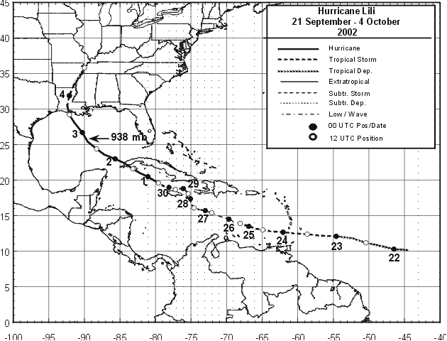
Figure 1:
Best track positions for Hurricane Lili, 21 September
- 4 October 2002.
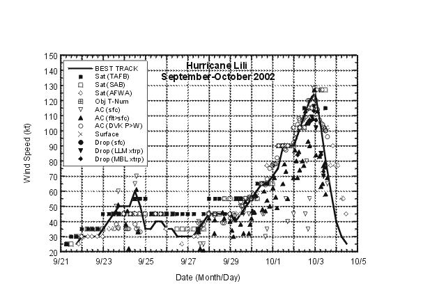
Figure 2:
Selected wind observations and best track maximum
sustained surface wind speed curve for Hurricane Lili, 21 September
- 4 October 2002. Aircraft observations have been adjusted for
elevation using 90%, 80%, and 80% reduction factors for
observations from 700 mb, 850 mb, and 1500 ft, respectively.
Dropwindsonde observations include surface estimates derived from
the mean wind over the lowest 150 m of the wind sounding (LLM) and
from the sounding boundary layer mean (MBL).
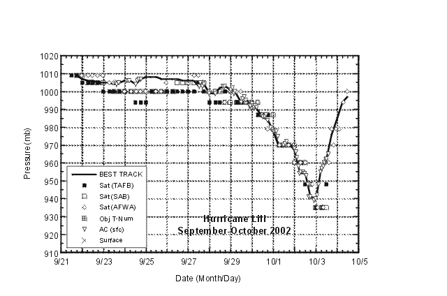
Figure 3:
Selected pressure observations and best track minimum
central pressure curve for Hurricane Lili, 21 September - 4 October
2002.
|


