Hilary briefly became a 65-knot hurricane while located about 200 n mi
southwest of the southern tip of Baja California, but did not affect
land.
a. Synoptic history
Hilary originated from a tropical wave that moved from west Africa to the
Atlantic on 29 August. It was a weak wave with minimal organized
convection as it moved across the tropical Atlantic and the Caribbean.
The wave acquired some organized convection on the 10th and
11th of September while over Central America. Visible satellite
imagery on the 17th showed a low-level circulation, along with
some organized deep convection, and a tropical depression is estimated to
have formed later that day, while centered about 475 n mi south-southeast
of the southern tip of Baja California, Mexico. The best track begins on the
17th, as indicated in Table 1 which is a listing, every six hours,
of best track positions, maximum one-min surface wind speeds, and minimum
central surface pressure. A map of the best track positions is shown in
Figure 1.
The depression was upgraded to a tropical storm on the 18th, based
on the low-level center being located under deep convection. Hilary had
been moving generally west-northwestward during this time as it slowly
strengthened. A deepening mid- to upper-level trough approached Hilary
from the northwest and the motion turned sharply toward the
north-northwest late on the 19th. A banding-type eye feature, increased
symmetry, and an enlarging of deep convection are the bases for upgrading
Hilary to a 65-knot hurricane for a short time early on the 20th,
while centered some 200 n mi southwest of the southern tip of Baja
California. Later that day, the low-level center became exposed to the
south of the deep convection and Hilary weakened to a tropical storm. The
cyclone moved over cool water and the weakening continued. Hilary was
reduced to a swirl of low clouds, devoid of deep convection on the 21st,
and the best track ends about 100 n mi west of Cabo San Lazaro, Baja
California.
b. Meteorological statistics
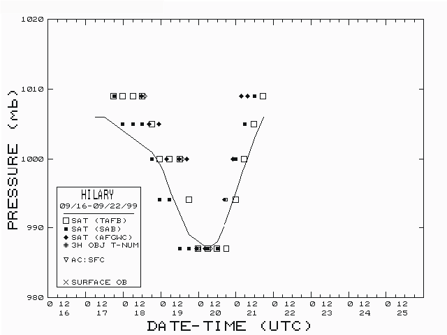
The best track pressure and wind speed time series curves are shown in
Figure 2 and Figure 3, along with
plots of the data on which the curves are based. Satellite-based intensity
estimates are the only available data, except that the ship SALUS
reported a 37-knot wind speed while located about 120 n mi east of the
center at 0000 UTC on the 20th.
c. Casualties and damages
Hilary did not affect land and there are no known deaths or damages.
d. Forecast and warning critique
There were 12 forecasts made while Hilary was a tropical storm and only
four of these verified at 48 hours and none verified at 72 hours. The
average track forecast errors were 45 n mi at 12 hours (10 cases), 81 n
mi at 24 hours (8 cases), 119 n mi at 36 hours (6 cases) and 194 n mi at
48 hours (4 cases). These errors are somewhat higher that the previous
10-year averages for the eastern Pacific basin. This is probably related
to the sharp right turn described above and the resultant left bias of
the official forecasts. Wind speed forecast errors were modestly small
as the intensification and weakening of Hilary were well-forecast.
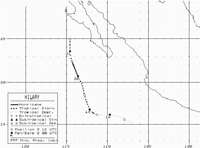
Figure 1.
Best track positions for Hurricane Hilary, 17-21 September 1999.
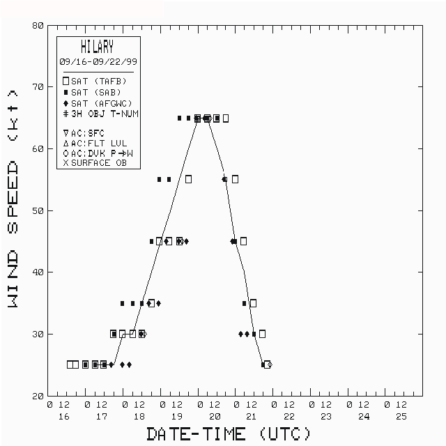
Figure 2.
Best track maximum 1-min sustained wind speed curve for Hurricane Hilary.

Figure 3.
Best track minimum central surface pressure curve for Hurricane Hilary.
Table 1.
Preliminary Best Track, Hurricane Hilary, 17-21 September 1999.
Date/Time
(UTC) |
Position |
Pressure
(mb) |
Wind Speed
(kt) |
Stage |
| Lat. (°N) |
Lon. (°W) |
| 17/0600 | 15.2 | 107.1 | 1006 | 25 | tropical depression |
| 1200 | 15.6 | 107.9 | 1006 | 25 | " |
| 1800 | 16.0 | 108.8 | 1005 | 25 | " |
| 18/0000 | 16.2 | 109.7 | 1004 | 30 | " |
| 0600 | 16.2 | 110.5 | 1003 | 30 | " |
| 1200 | 16.2 | 111.3 | 1002 | 35 | tropical storm |
| 1800 | 16.4 | 111.8 | 1001 | 40 | " |
| 19/0000 | 16.8 | 112.2 | 999 | 45 | " |
| 0600 | 17.5 | 112.5 | 995 | 50 | " |
| 1200 | 18.5 | 112.8 | 992 | 55 | " |
| 1800 | 19.7 | 113.1 | 989 | 60 | " |
| 20/0000 | 20.7 | 113.6 | 988 | 65 | hurricane |
| 0600 | 21.6 | 114.0 | 987 | 65 | " |
| 1200 | 22.4 | 114.3 | 988 | 60 | tropical storm |
| 1800 | 23.0 | 114.5 | 991 | 55 | " |
| 21/0000 | 23.6 | 114.6 | 995 | 45 | " |
| 0600 | 24.3 | 114.6 | 999 | 40 | " |
| 1200 | 24.9 | 114.6 | 1003 | 30 | tropical depression |
| 1800 | 25.3 | 114.5 | 1006 | 25 | " |
| 22/0000 | | dissipated |
| |
| 20/0600 | 21.6 | 114.0 | 987 | 65 | minimum pressure |
![[NCEP Logo]](graphics/ncep.gif)