 |
| For
Your Information |
| Every once in awhile, there will be a weather
related topic that may interest you. One such topic is found
below. |
|
|
 |
Dedication of Flood Warning System in Hot Springs, AR |
 |
| |
| The city of Hot Springs, Arkansas is a popular
destination for thousands of tourists each year. The area is
most known for its lakes, horse racing, and thermal waters/bathhouses.
But it is also known for flash flooding, with numerous high water events
that have swept into town from the surrounding hills.
During the evening of May 19, 1990...more than six inches of rain fell in a few hours. Cars and people were washed down
Central Avenue in more than four feet of water. On April 9, 2008...the
basements of several bathhouses were flooded, and high water threatened
many businesses.
Heavy rain and flash flooding have long been a safety concern for
residents and tourists alike. City officials have looked for ways to
better monitor rainfall and rising water.
|
 |
In a joint effort of the U.S. Geological Survey (USGS), the National Park Service (NPS), the City of Hot Springs, and the National Weather
Service (NWS)...a new flood warning system was designed and installed.
The system was dedicated on July 22, 2008. |
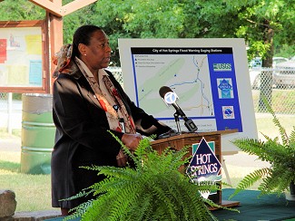
| In the picture:
Renee Fair, Meteorologist-in-Charge at the National Weather Service in
Little Rock (Pulaski County), speaks at the dedication ceremony. Click
to enlarge. |
| This network is comprised of seven rain gages, of which five also include float well stream height monitoring devices. |
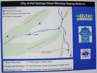 |
| In the picture:
A map showing a network of gauges in the Hot Springs (Garland County)
area...most notably along Whittington Creek and Hot Springs Creek. Click
to enlarge. |
|
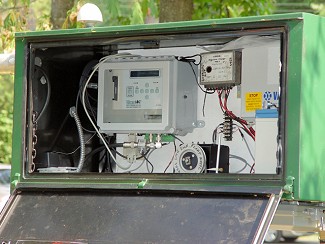
Rainfall data in 5 minute increments is transmitted to the NWS via HADS
(Hydrometeorological Automated Data System) every hour, along with the stream heights along Hot Springs Creek and Whittington Creek. |
| In the picture:
An equipment box (used to measure and transmit rainfall and stream
height data) at Whittington Park in Hot Springs (Garland County). Click
to enlarge. |
| The data will greatly assist the NWS in issuing timely
Flash Flood Warnings in an effort to fulfill its mission...protecting
life and property. |
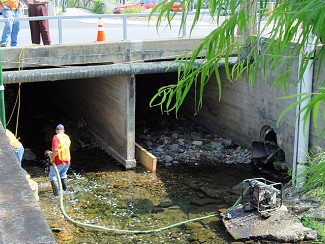 |
| In the picture:
The downstream Hot Springs Creek tunnel (arch) at Grand Avenue...or
station number 6 on the map above. Click to
enlarge. |
|
|