 |
||||
|
|
|
|||


| |
Lake Circulation Studies and the Great Lakes Coastal Forecast System (GLCFS)
Collaborators
Dima Beletsky, Cooperative
Institute of Limnology and Ecosystems Research (CILER
web site)
Ed Rutherford, University of Michigan Natural Resources and the Environment
(NRE web site)
Executive Summary
This project is designed to develop and fully implement a system of computerized models that can simulate and predict the three-dimensional structure of currents, temperatures, water level fluctuations, wind waves, ice, and sediments in the Great Lakes. The project will integrate these models with the required observational data systems into a real-time coastal prediction system. The project will make the information developed from this system available in a useful format and in a timely fashion to National Weather Service (NWS web site) forecasters, coastal users and resource managers.
Project Rationale
The forecasting system will be useful to all users of the Great Lakes coastal waters who require real-time information and forecasts of temperatures, currents, water levels, and waves. Physical processes have a major impact on environmental, chemical, and biological processes and influence many other types of user activities, such as water supply management, waste water management, power plant sitings, shipping, recreational and commercial boating and fishing, shoreline erosion and redistribution of sedimentary material. Planners and managers responsible for any part of the Great Lakes ecosystem that is affected by lake circulation, such as transport of toxic material or nutrient enrichment processes will have full access to the information provided by Great Lakes Coastal Forecast System (GLCFS web site) to assist them in the decision making process. The forecasts of lake waves, water levels, water temperatures, and currents are expected to provide NWS marine forecasters with a significant source of new information which should lead to considerable improvements both in the accuracy and efficiency of marine forecasts for the Great Lakes.
FY06 Figure 1 Screen shot from workstation-based Great
Lakes Coastal Forecasting System at the Great Lakes Environmental Research
Laboratory. By operating a research-based version of GLCFS at GLERL in
parallel with the operational version at National Ocean Service Center
for Operational Oceanographic Products and Services, we will be able to
develop and test new applications of coastal forecast systems including
ecological forecasts and beach closure forecasts.
+ GLCFS research based version
2006 Project Objectives
The objectives of the GLCFS project are:
- Fully implement a system of computerized models that can simulate and predict the three-dimensional structure of currents, temperatures, water level fluctuations, wind waves, ice, and sediments in the Great lakes;
- Integrate these models with the required observational data systems into a real-time coastal prediction system;
- Make the information developed from this system available in a useful format and in a timely fashion to NWS forecasters, coastal users and resource managers.
The specific work for 2006 has four components:
- Continue operation of workstation-based GLCFS at the Great Lakes Environmental Research Laboratory (GLERL). By operating a research-based version of GLCFS at GLERL in parallel with the operational version at National Ocean Service (NOS web site) Center for Operational Oceanographic Products and Services (CO-OPS web site), we will be able to develop and test new applications of coastal forecast systems including ecological forecasts and beach closure forecasts. In 2006 we plan to improve the spatial resolution of Lake Michigan and Lake Erie from 5 km to 2 km and to include seasonally averaged tributary flows in the Lake Erie model. These two lakes have already become operational at NOS CO-OPS at 5 km resolution. In order to increase the resolution of Lakes Erie and Michigan, we will need to move GLCFS from the five-year-old computer workstation it is currently running on (HP B2000) to a more suitable development platform.
- A work plan has been developed by NOS CO-OPS to implement GLCFS as part of their suite of coastal ocean prediction systems. Lakes Michigan and Erie became operational at NOS CO-OPS in 2005. GLERL will continue to assist in this process by providing consultation and advice on how best to accomplish this transfer. In turn, as NOS modifies GLERL GLCFS program code to fit within their modeling framework, GLERL will revise our codes to match NOS changes in order to insure future compatibility.
- A work plan has been developed by NWS National Center for Environmental Prediction (NCEP web site) to implement operational Great Lakes wave forecasts using the WaveWatch III model. As this system is developed, GLERL will be working closely with NCEP scientists to ensure that the wave products from WaveWatch II are as good or better than GLERL's GLCFS wave products.
- D. Schwab will continue to act as Steering Committee Chairman for a NOAA Coastal Services Center (NCS web site) funded project with the Great Lakes Commission to begin developing a conceptual framework for operating a Regional Ocean Observing System for the Great Lakes. Products from GLCFS will be a key component of an integrated Great Lakes observation and forecast system.
![]()
Program Accomplishments
2005 | 2004 | 2003 | 2002 | 2001 | 2000 | 1999 | 1998
2005 Accomplishments
This project is designed to develop and fully implement a system of computerized models that can simulate and predict the three-dimensional structure of currents, temperatures, water level fluctuations, wind waves, ice, and sediments in the Great Lakes. The project will integrate these models with the required observational data systems into a real-time coastal prediction system. In 2005 the main accomplishments were to continue operation of workstation-based GLCFS at GLERL, assisting NOS CO-OPS in implementing operational systems for Lake Erie and Michigan, assisting NCEP in comparing results from their WaveWatch III model for the Great Lakes to GLCFS wave forecasts, and implementing a scheme for assimilation of ice conditions into the hydrodynamic and wave models of GLCFS. In addition, Dave Schwab continued to act as chairman of the Scientific Steering Committee for the development of the Great Lakes Observation System component of Integrated Ocean Observing System (IOOS web site).
The specific work for 2005 had five components:
- Continued operation of workstation-based GLCFS at GLERL. This activity puts GLERL in a position to transfer GLCFS to NOAA operational units in the most efficient manner and will provide the opportunity to develop and participate in new research projects related to coastal forecasting in the Great Lakes. Two potential avenues for transfer to NOAA operational units have been identified (NCEP and NOS CO-OPS) and are being pursued. In the meantime, GLCFS products are being disseminated from GLERL to NWS forecast offices through the Advanced Weather Interactive Processing System (AWIPS web site). The GLERL workstation version of GLCFS operated nearly continuously in 2004. Numerous requests for various GLCFS data and products from outside organizations were filled during 2005.
- A work plan has been developed by NOS CO-OPS to implement GLCFS as part of their suite of coastal ocean prediction systems. GLERL provided significant assistance in this process by providing consultation and advice on how best to accomplish this transfer. In turn, as NOS modifies GLERL GLCFS program code to fit within their modeling framework, GLERL will revise our codes to match NOS changes in order to insure future compatibility. In 2005, NOS completed work on implementing the code for Lakes Erie and Michigan.
Operational products for each of the five Great Lakes can be accessed via the web at the Great Lakes Operational Forecast System (GLOFS web site): http://tidesandcurrents.noaa.gov/ofs/glofs.html

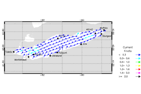
FY05 Figure 1. Sample products from Lake Michigan Operational Forecast System (left) [LMOFS web site] and Lake Erie Operational Forecast System (right) [LEOFS web site]. The Lake Michigan graph shows water temperature forecasts and the Lake Erie graph shows surface current forecasts. In addition, a GLERL Quarter 4 milestone on the transfer of GLCFS to NOS was completed.
- A work plan has been developed by NWS NCEP to implement operational Great Lakes wave forecasts using the WaveWatch III model. As this system is developed, GLERL will be working closely with NCEP scientists to ensure that the wave products from WaveWatch II are as good or better than GLERL's GLCFS wave products. Wave nowcasts from GLCFS at all Great Lakes NDBC buoys for the 2004 open water season have been assembled and transferred to NCEP for comparison with Wave Watch III hindcasts.
- In 2005 we implemented a scheme for assimilation of ice conditions into the hydrodynamic and wave models of GLCFS. The bi-weekly ice charts for the Great Lakes which are produced at the National Ice Center are re-gridded to GLCFS grids and used to adjust surface momentum and heat fluxes into the GLCFS models for nowcasts. In addition, experiments were conducted with ice dynamics models to predict ice conditions in the 48 hour GLCFS hydrodynamic model forecasts. This work was carried in collaboration with Dmitry Beletsky at CILER. 5) D. Schwab continued to act as Steering Committee Chairman for a NOAA/CSC-funded project with the Great Lakes Commission to begin developing a conceptual framework for operating a Regional Ocean Observing System for the Great Lakes. Products from GLCFS will be a key component of an integrated Great Lakes observation and forecast system. In 2005, a business plan and governance structure for GLOS were developed and steps were taken to formally incorporate the regional association as a Michigan 501-C3 organization.
![]()
2004 Accomplishments
The specific work for 2004 had five main accomplishments:
- Operation of workstation-based GLCFS at GLERL. The workstation-based GLCFS and associated web site were operated for all five lakes producing nowcast information four times per day and 60 hour forecasts twice per day virtually without interruption through CY04. This activity keeps us in a position to transfer GLCFS to operational units in the most efficient manner and provides the opportunity to develop and participate in new research projects related to coastal forecasting in the Great Lakes.
- A specific technology transfer project with assigned NOS staff and other associated resources was initiated by NOS CO-OPS to transfer the hydrodynamic forecasting part of GLCFS to NOS operations. Lakes Michigan and Erie are scheduled to be completed in CY05 and the other lakes in CY06.
- Wave forecasts generated by GLCFS were transmitted through the National
Weather Service
Telecommunication Gateway (NWSTG web site) to NWS forecast offices and made available to forecasters on their AWIPS workstations for routine marine forecasting operations.

FY 04 Figure 1. AWIPS graphical display of GLCFS wave forecasts.
2003 Accomplishments
Considerable progress was made toward developing an operational real-time coastal prediction system for the Great Lakes. We are still in the process of transferring this system to NWS operations and fully implementing the system for all five lakes. Because we have no control of when this transfer will occur, and because GLCFS is valuable for several other ongoing research projects at GLERL, we propose to continue operations at GLERL on a year-to-year basis at GLERL.
The specific work for 2003 had two main components:
- Continued operation of workstation-based GLCFS at GLERL. This activity put us in a position to transfer GLCFS to operational units in the most efficient manner and will provide the opportunity to develop and participate in new research projects related to coastal forecasting in the Great Lakes. Two potential avenues for transfer to NOAA operational units have been identified (NCEP and NOS CO-OPS) and are being pursued. In the meantime, GLCFS products are being disseminated from GLERL to NWS forecast offices through AWIPS (the NWS advanced weather information processing system).
- Continue development of coastal forecast system for Lake St. Clair in collaboration with G. Meadows and the Dept. of Naval Architecture and Marine Engineering at U.M. This system will also be used part of a large proposal to be written for an Michigan Department of Environmental Quality (MDEQ web site) Great Lakes Coastal Restoration Grant. GLERL's part of the request would be for graduate student support ADCP costs, and computer equipment. This proposal was not funded by MDEQ, but the preliminary work on Lake St. Clair was written up as a NAME report.
2002 Accomplishments
We fully implemented hydrodynamic and wave model nowcasts and forecasts for all five lakes in the GLERL version of the Great Lakes Coastal Forecasting System. This required the addition of hydrodynamic model runs and graphical output products for Lakes Ontario and Superior. In addition, a graphical product for surface currents was developed and implemented for all five lakes. The driving function for GLCFS forecasts is the numerical weather model predictions from NCEP's Eta model. This year we changed the way we acquire the NCEP forecasts from internet-based to NOAAPORT (satellite-based) to ensure more reliable and timely operation. This has decreased the time delay between completion of the Eta model forecasts and GLCFS forecasts to less than an hour. We also have worked with NWS to provide wave model forecast data in a format (GRIB) which is compatible with NWS AWIPS workstation software so that wave forecasts can be displayed seamlessly with all other weather information at NWS offices. The GRIB files are disseminated through the NWS telecommunications gateway and NOAAPORT to all NWS offices.
Meetings and discussions were held with NWS and NOS concerning transfer of GLCFS operations to NCEP or NOS/COOPS. When a decision is reached, GLERL will provide any required assistance in the transfer.
We continued development of the hydrodynamic modeling component of a nowcast/forecast system for Lake St. Clair in collaboration with G. Meadows at U.M. This work is in support of a large project on Lake St. Clair water quality which has been proposed for funding through an MDEQ Great Lakes Coastal Restoration Grant. A decision on funding is still pending.
2001 Accomplishments
The specific work for 2001 had five main components:
- Added Lake Michigan hydrodynamic model to forecast system. The system now includes nowcasts and forecasts for waves for all five lakes (using the GLERL/Donelan model) and nowcasts and forecasts for 3-d circulation for Huron, Michigan, and Erie (using the GLERL version of the POM model).
- Forecasts are now updated twice a day with wind stress and heat flux from the new NCEP 22km meso-eta model meteorological forecasts
- Lake Huron nowcasts for waves and circulation are being supplied to the NWS DTX office for use as initial conditions for wave and circulation forecasts which are based on workstation-eta atmospheric forecasts being generated at DTX as part of a COMET project with U. of Mich.
- Wave forecasts are being supplied to NWS/TDL for use in a demonstration of AWIPS/IFPS at NWS Grand Rapids office.
- Many of the GLCFS graphical products are also transferred to the NWS Cleveland Office and disseminated to the shipping community through the Cleveland DMAWDS system.
2000 Accomplishments
We are now in the process of transferring this system to NWS operations and fully implementing the system for all five lakes. Because we have no control of when this transfer will occur, and because GLCFS is valuable for several other ongoing research projects at GLERL, we propose to continue operations at GLERL on a year-to-year basis at GLERL. Improved data acquisition software for NOAAPORT (NOAAPORT web site).
1999 Accomplishments
Nowcasts of three-dimensional circulation and water temperature are being produced for Lakes Erie, Ontario, and Michigan as well as wave forecasts and nowcasts for all five lakes. We are now in the process of transferring this system to the NWS operations. A workstation- based version of GLFS has been developed at GLERL as a prototype for implementation in NWS forecast offices. Input data for nowcasts is obtained from the NOAAPORT satellite-based acquisition system for real-time meteorological data (Figure1.). Forecasts of waves, water levels, currents, and water temperatures are based on meteorological forecasts from the Eta-32 model at NCEP. Nowcasts are updated four times per day and forecasts are updated twice daily. Products consist of maps and animations of two and three dimensional wave, water level, current, and water temperature fields. Validation against observed wave conditions, water temperatures, and water level fluctuations has been encouraging. The nowcasts part of the system, which is based entirely on observed meteorological data, relies on objective analysis to provide ridded meteorology for the hydrodynamic models. A new geometrically-based method of objective analysis called the Natural Neighbor technique will soon be implemented into the nowcast system. This technique produces interpolated fields with more realistic spatial structure than other techniques we have used, particularly for observation networks with highly irregular spacing.

FY 99 Figure 1. This shows the new satellite dish for collecting the NOAAPORT data stream and the team that is assembling the system to make the data usable for the researchers at GLERL.
![]()
1998 Accomplishments
In 1998, the National Weather Service (NWS) continued reviewing plans for the future of the Great Lakes Marine Program at the Weather Service Forecast Office (WSFO) in Cleveland, Ohio. Depending on the outcome of these plans, Great Lakes Coastal Forecasting System (GLCFS) could be transferred to WSFO Cleveland for operational implementation. Alternatively, parts of the system could be transferred to individual WSFOs for operation on individual lakes, and the whole system could be transferred to the NCEP Marine Prediction Center in Washington, DC or it could remain as a demonstration project operated at GLERL. In 1998, we also investigated the possibility of transferring the system to the National Ocean Service (NOS) Oceanographic Products and Services Division, which operates the Physical Oceanographic Real-Time System (PORTS) for San Francisco Bay, New York/New Jersey Harbor, Houston/ Galveston, Tampa Bay, and Chesapeake Bay. To be in a position to provide an operating GLCFS to any of these agencies, it is necessary for GLERL to continue operation of GLCFS in demonstration mode. This operation complements the public GLFS operated by Ohio State University (OSU) as many of the changes and improvements made at GLERL are incorporated into the OSU system.
In the past year at GLERL, GLCFS has undergone Y2K certification, which involved modifying program code, control scripts, and file naming conventions to accommodate a four digit year. In addition, in June of 1998, NCEP implemented a new version of the ETA mesoscale weather forecast model, which required several changes in the data acquisition procedures and data processing procedures for GLCFS forecasts.
Publications
As-Salek, J. A., and D.J. SCHWAB. 2004. High frequency water level fluctuations in Lake Michigan. Journal of Waterway, Port, Coastal and Ocean Engineering:45-53.
BELETSKY, D., K.K. Lee and D.J. SCHWAB, 1998. Large-scale circulation. In: D.Lam (Ed.) Climatic effects on lake hydrodynamics and water quality, ASCE, 4.1-4.42.
BELETSKY, D., J.H. SAYLOR, and D.J. SCHWAB. 1999. Mean circulation in the Great Lakes. J. Great Lakes Res. 25, 78-93. http://www.glerl.noaa.gov/pubs/fulltext/1999/19990004.pdf
BELETSKY, D. and D.J. SCHWAB. 2001. Modeling circulation and thermal structure in Lake Michigan: Annual cycle and interannual variability. J. Geophys. Res 106:19745-19771. http://www.glerl.noaa.gov/pubs/fulltext/2001/20010008.pdf
HOOK, T. O., E. S. Rutherford, S. J. Brines, D. M. MASON, D. J. SCHWAB, M. J. McCORMICK, G. W. Fleischer and T. J. DeSorcie. 2003. Spatially explicit measures of production of young alewives in Lake Michigan: linkage between essential fish habitat and recruitment. Estuaries 26(1):21-29.
Kelley, J.G.W., J.S. Hobgood, K.W. Bedford and D.J. SCHWAB, 1998. Generation of Three-dimensional lake model forecasts for Lake Erie. Weather and Forecasting, 13, 659- 687.
Lee, C.-H., D. J. SCHWAB, and N. HAWLEY. Sensitivity analysis of sediment resuspension parameters in coastal area of southern Lake Michigan. Journal of Geophysical Research 110(C03004):16 (2005). http://www.glerl.noaa.gov/pubs/fulltext/2005/20050018.pdf
LIU, P.C., SCHWAB, D.J., and Jensen, R.E. 2002. Has wind-wave modeling reached its limit? Ocean Engineering 29:81-98.
O'Connor, W.P., D.J. SCHWAB, and G.A. LANG, 1999. Forecast verification for Eta Model winds using Lake Erie storm surge water levels. Weather and Forecasting, 14, 119-133.
SCHWAB, D.J. and D. BELETSKY, 1998. Propagation of Kelvin Waves Along Irregular Coastlines in Finite-difference Models. Advances in Water Resources, 22, 239-245.
SCHWAB, D.J. and K.W. Bedford, 1999. The Great Lakes Forecasting System, in Coastal Ocean Prediction (ed. C.Mooers), Amer. Geophys. Union Coastal and Estuarine Studies. 157-174.Amer. Geophys. Union Coastal and Estuarine Studies. 157-174.
SCHWAB, D.J., LESHKEVICH, G.A., and MUHR, G.C. 1999. Automated mapping of surface water temperature in the Great Lakes. J. Great Lakes Res., 25(3), 468-481. http://www.glerl.noaa.gov/pubs/fulltext/1999/19990006.pdf
SCHWAB, D. J., and D. BELETSKY. 2003. Relative effects of wind stress curl, topograph, and stratification on large scale circulation in Lake Michigan. Journal of Geophysical Research 108(C2):26-1 to 26-6. http://www.glerl.noaa.gov/pubs/fulltext/2003/20030018.pdf
Milestones
2003 Q1 Milestone: Implement routine distribution of GLERL Coastal Forecasting System wave forecasts for the Great Lakes to NWS offices via NOAAPORT or other communications systems
Last updated: 2006-08-03 mbl