
|
||
|
|
||
|
|
 The Mission Control presents information on current and
planned Earth observing missions.
The Mission Control presents information on current and
planned Earth observing missions.
Spacecraft Overpass Predictions are now available for the Earth Observing satellite fleet and many other objects on-orbit!
TRACK Earth Observing satellites with NASA/MSFC's J-Track utility. We're currently tracking Terra, Landsat-7, TRMM, OrbView-2 (SeaSat), and QuikSCAT.
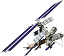 ISS & Space Shuttle
Earth Observatory Articles:
Human Spaceflight Fact Sheet
Astronaut Photography
6-m Spatial Resolution from Intenational Space Station
Project, science, data, and satellite sites:
Gateway to Astronaut Photography (JSC)
Earth from Space Collection
ISS Images @ NASA's Visible Earth
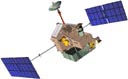
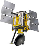
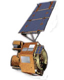
 OrbView-2
The OrbView-2 spacecraft, also known as SeaStar, carries the SeaWiFS (Sea-viewing Wide Field-of View Sensor) instrument for remote sensing of ocean color.
Current location & coverage information:
SeaWiFS Location
SeaWiFS Daily Coverage
Latest Images:
Global Biosphere
Project, science, data, and satellite sites:
SeaWiFS Project
OSC - Orbview 2
 TRMM
TRMMLatest Images:
Quick look data
Project, science, data, and satellite sites:
TRMM Project
TRMM Overpass Predictions
 Landsat-7
Latest Images:
Landsat 7 Browse Image Gallery
Project, science, data, and satellite sites:
Landsat 7 Project
Landsat 7 Images @ NASA's Visible Earth
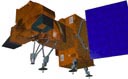
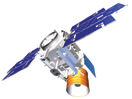
 QuikSCAT
The QuikSCAT spacecraft carries the SeaWinds instrument for high-resolution remote sensing of near-surface winds over global oceans. QuikSCAT launched successfully on June 19, 1999, as a successor to the NASA Scatterometer mission.
Project, science, data, and satellite sites:
QuikSCAT Project
QuikSCAT Images @ NASA's Visible Earth
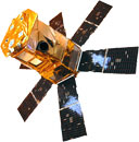
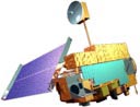 Terra
Terra
Terra launched aboard an Atlas-Centaur IIAS expendable launch vehicle from Vandenberg Air Force Base, California at 1:57 p.m. EST on December 18, 1999.
You can view Terra launch and deploy animations - including new 3-D models of the Terra Spacecraft - in the Earth Observatory's Reference Room.
Project, science, data, and satellite sites:
Terra Home Page
Terra Images @ NASA's Visible Earth
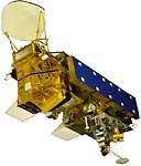 Aqua (formerly EOS PM-1)
You can view Aqua launch and deploy animations in the Earth Observatory's Reference Room.
Project, science, data, and satellite sites:
Aqua Home Page
Aqua Project
Science
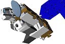 Aura (formerly EOS Chem)
Project, science, data, and satellite sites:
Aura Home Page
 Earth Observing-1 (EO-1)
A Delta 7320-10 carrying the EO-1 and SAC-C spacecraft lifted off from Vandenberg Air Force Base at 1:24 pm EST on November 21, 2000. After deployment from the second stage of the Delta, EO-1 will fly in a 705 km circular, sun-synchronous orbit at a 98.7 degree inclination. It will follow along Landsat 7's ground track one minute behind Landsat 7, and will demonstrate new remote sensing technologies.
Project, science, data, and satellite sites:
EO-1
Project Home Page
 ICESat (Ice, Cloud, and land Elevation Satellite)
The ICESat spacecraft carries a Geoscience Laser Altimeter System (GLAS) for measuring the elevations of ice sheets as well as changes in their elevations over time. The GLAS sensor also measures height profiles of clouds and aerosols, land elevations, vegetation cover, and approximate ice thickness. The mission is mainly designed to help scientists understand and predict how ice sheets and future sea levels will change as Earth's climate changes.
Project, science, data, and satellite sites:
ICESat Home Page
ICESat Factsheet
 SORCE (SOlar Radiation and Climate Experiment)
Earth scientists will move a step closer to a full understanding of the Sun's energy output when NASA launches the Solar Radiation and Climate Experiment (SORCE) satellite on January 25, 2003. SORCE will be equipped with four instruments that will measure variations in solar radiation much more accurately than anything now in use and observe some of the spectral properties of solar radiation for the first time. With data from NASA's SORCE mission, researchers should be able to follow how the Sun affects our climate now and in the future.
Project, science, data, and satellite sites:
SORCE Home Page
SORCE Factsheet