 |
 |
FY 2002 Operating Plan for PMELGOAL: SUSTAIN HEALTHY COASTSObjective 3: Foster Well-planned and Revitalized Coastal Communities That Sustain Coastal Economies, are Compatible with the Natural Environment, Minimize the Risks from Natural Hazards, and Provide Access to Coastal Resources for the Public’s Use and Enjoyment Performance Measure: Number of improved information management tools developed to assist coastal hazard mitigation
Purpose: The
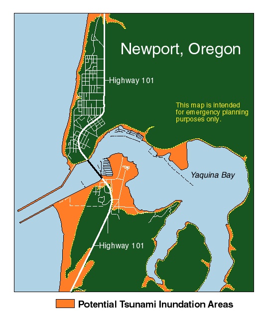
National Tsunami Hazard Mitigation Program (NTHMP) was formed in Customers: NTHMP customers are the coastal communities of the five Pacific states and the four to ten million people of those communities who live, work, and recreate within potential tsunami inundation zones. Efforts: During the five-year period 1996-2001, the period of the first Implementation Plan of the NTHMP, numerous improvements in the Nation’s tsunami hazard preparedness were put into place. First and foremost, affected populations have become more aware of the potential dangers. Emergency managers have instilled the need in community planners to take tsunami hazards into account in land-use decisions. Residents and tourists have been made aware of hazards as represented through the development of programs such as Tsunami-Ready community designation in coastal communities. Evacuation maps have been developed by emergency planners, based on risk assessments driven by scientifically-based model output completed by the states and NOAA. Tsunami warning systems have been improved by the development of deep-ocean moored buoys to provide early warning of a tsunami and a major upgrade of the USGS seismic network. In August, 2001, a 5-year review was held in Seattle to assess the developments of the NTHMP program and develop plans to sustain the momentum created by the activities of the first five years. Significance: The 2002-2007 five-year plan builds on the successes realized in the initial five years of the program. The goals for the program for the next five years are described in three major thematic areas: Hazard Assessment, Warning Guidance, and Mitigation Activities.
Warning Guidance will be improved by a number of actions, the goals of
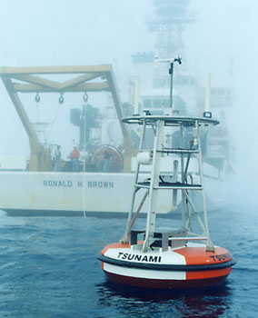
which are to: 1) reduce the average time to issue bulletins for local
tsunamis (US coastal areas) to 8 minutes from the
Success: This plan has been completed and approved by the five states and three federal agencies that comprise the NTHMP. Implementation began in November, 2002 when the NTHMP Steering Group approved ten proposals from the five states and three federal agencies. Some delay is anticipated in implementing these proposals due to the limitations that accompany the current Continuing Resolution. In 2003, the NOAA focus of NTHMP activities will shift from OAR to NWS. As a result of the November, 2002 NTHMP annual meetings, it was agreed that Mr. Jeff LaDouce, NWS Pacific Region Director, would succeed Dr. Bernard as NTHMP chairman by fall, 2003. Next Steps: NWS, OAR, FEMA, USGS, and the five Pacific states are involved in carrying out the goals of the 2001 Implementation Plan. The most visible activity within NOAA, the transfer of responsibility for the Detection and Reporting of Tsunamis (DART) buoys in the Pacific Ocean is in the process of being completed, and it is anticipated that this transfer in operational responsibility for this Array from PMEL to NWS/National Data Buoy Center (NDBC) will be complete by the end of FY 2003. GOAL: IMPLEMENT SEASONAL TO INTERANNUAL CLIMATE FORECASTS Objective 2: Maintain and Improve Observing and Data Delivery Systems Performance Measure: Increase the cumulative number of ocean observations that are critical for improving climate analyses forecasts. (Metrics: Number of platforms (of given types) globally reporting near real time data.)
Purpose: The TAO/TRITON Array is a primary component of the ENSO Observing System. As such it provides realtime ocean and atmosphere observations for use in climate research and prediction. The NOAA-managed portion of the Array, the Tropical Atmosphere-Ocean (TAO) Array, was based on ATLAS mooring technology developed by PMEL in the early 1980’s, utilizing older thermistor chain temperature technology. These “first-generation” ATLAS moorings lacked the flexibility to incorporate more or improved sensors to the basic configuration.
Efforts: A newer technology (referred to as NextGeneration ATLAS), developed at PMEL in the mid-1990’s, utilizes independent sensor control and data archiving at subsurface measurements and an inductive method of data telemetry to the sea surface. In addition, the new mooring system provides easier assembly, deployment and recovery, greater flexibility in sensor payloads, higher temporal resolution, and higher accuracy of some measurements. New measurements include short-wave and long-wave radiation, precipitation, salinity, ocean currents and barometric pressure. The NextGeneration ATLAS moorings were first introduced into the TAO array beginning in 1996, but funding limitations required a gradual transition to a full array of NextGeneration ATLAS moorings. Completing the transition to the new inductively coupled temperature technology required development of a entire new set of procedures and software, including those for calibration, archiving, displaying and analyzing calibration data, shipboard monitoring of sensor output during field operations, and real-time processing and quality analysis of mooring data. Development of these procedures and software also provided the opportunity to design and develop a new and modern data-base which integrated data and metadata which had previously been on separate or antiquated systems. Customers: Operational TAO data are delivered via the GTS to operational centers throughout the world. Researchers, policy makers, students and the general public also have access to the data though the world-wide web. These new high-resolution flux data and in-situ open-ocean precipitation and radiation data provide unique opportunities for various investigations, eg., PACS-EPIC process studies currently in progress, satellite verification, etc. Significance: NextGeneration ATLAS technology offers much greater flexibility to incorporate new and improved sensors at the mooring sites. The additions of long and short-wave radiation measurements, rainfall, barometric pressure, subsurface currents, and subsurface salinity measurements now make it possible to systematically study the upper ocean heat and salt balances, and to diagnose atmospheric boundary layer variability. These expanded capabilities also make it possible to use ATLAS mooring surface flux measurements to validate satellite and numerical weather prediction model-derived surface heat and moisture fluxes, which are of questionable quality but which are also deemed essential for advancing studies of the couple ocean-atmosphere system on a global basis. Success: All Standard Atlas moorings have now been recovered and retired and the TAO array is now comprised entirely of NextGeneration ATLAS moorings. New, enhanced measurements are being processed with a new set of procedures and software. The uniformity of instrument systems coupled with the integration and improvements to data systems have provided a significant increase in the efficiency with which the TAO Array is maintained and these important data are provided to users. Next Steps: The NextGeneration ATLAS mooring system permits the flexibility to accommodate design improvements in existing sensors, entirely new sensor systems, and the capability for scientists to redesign the temporal and spatial parameters as new scientific questions evolve. The ATLAS system is now much better positioned to deliver the information that climate scientists need to improve our understanding of the ENSO phenomenon. Among possible new additions to the sensor suite is ocean carbon time series measurements for study of the global carbon cycle. GOAL: DOCUMENT, PREDICT, AND ASSESS DECADAL-TO-CENTENNIAL CHANGE Objective 1: Characterize the Forcing Agents of Climate Change Performance Measure: Results of 90% of the research activities are to be cited in the next Intergovernmental Panel on Climate Change (IPCC) Assessment of Climate Change Subject: Monitoring, process studies, and modeling associated with climate related aerosols
Objective 2: Understand the Role of the Oceans in Global Change Performance Measure: Results of 90% of the research activities are to be cited in the next Intergovernmental Panel on Climate Change (IPCC) Assessment of Climate Change Purpose: Atmospheric aerosol particles affect the Earth's radiative
balance both directly by scattering and absorbing solar radiation and
indirectly by modifying the optical properties and lifetime of clouds
(Figure 1). Although aerosols have a potential climatic importance over
and down wind of industrial regions that is equal to that of anthropogenic
greenhouse gases [IPCC, 1996], they are still poorly characterized in
global climate models. This is a result of a lack of both globally distributed
data and a clear understanding of the processes linking gaseous precursor
emissions, atmospheric aerosol properties, and the spectra of aerosol
optical depth and cloud reflectivity. At this time, tropospheric aerosols
pose one of the largest uncertainties in model calculations of climate
forcing [IPCC, 1996]. This uncertainty significantly limits our ability
to assess the effect of natural and human induced changes in the chemistry
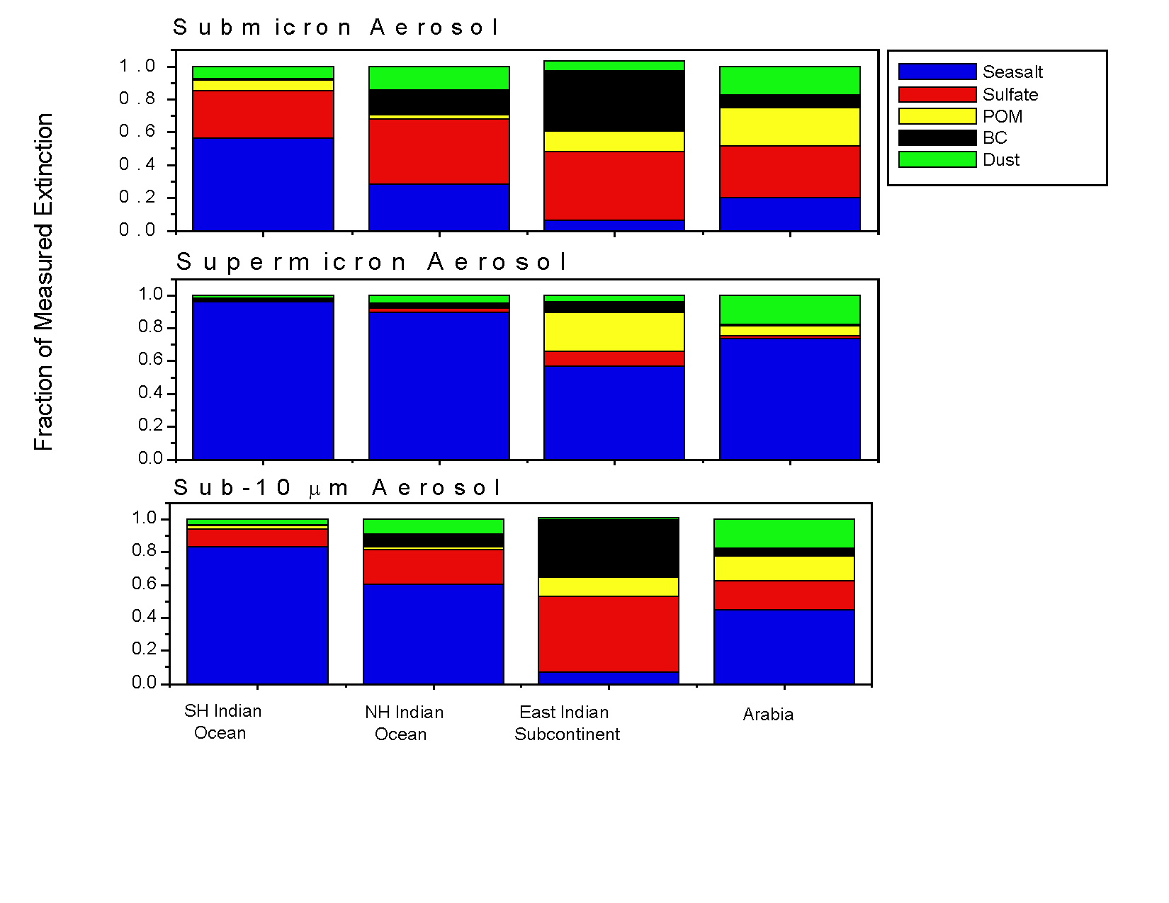
of the atmosphere on global climate. Efforts: The Indian Ocean Experiment (INDOEX) was designed to contribute to a better predictive understanding of the role of anthropogenic aerosols in climate forcing. INDOEX focused on the radiative effects and controlling processes of anthropogenic aerosols from the Indian subcontinent and nearby nations as they were transported over the Indian Ocean. The experiment, which took place in February and March of 1999, involved two ships, three aircraft, two field stations, satellite observations, and a modeling component. NOAA PMEL participated in the shipboard measurements aboard the NOAA research vessel Ronald H. Brown. Customers: The INDOEX data sets have been and are being used to evaluate numerical models that extrapolate aerosol properties and processes from local to regional scales and to assess the regional direct and indirect radiative forcing by aerosols. Significance: Initial results from the 1999 INDOEX field experiment appeared in the November 27th, 2001 issue of the Journal of Geophysical Research - Atmospheres. A second special issue is in preparation and will be published in 2002. Success: Highlights of the NOAA results include: (1) Measurements made onboard the RV Ronald H. Brown indicated a large degree of variability in aerosol chemical and optical properties in the marine boundary layer over the Indian Ocean due to the wide range of aerosol sources that impact the region and to changing transport pathways from the Indian subcontinent and nearby nations to the marine atmosphere (Figure 2). (2) The southern hemisphere Indian Ocean aerosol was relatively uninfluenced by continental sources. Aerosol chemical composition, scattering and absorption coefficients, and optical depth for this region were similar to what has been reported for remote regions of the Pacific and Atlantic Oceans. Sea salt dominated extinction by submicron and sub-10 mm particles. (3) The northern hemisphere Indian Ocean had elevated black carbon and sulfate aerosol concentrations as well as lower single scattering albedo values indicating the transport of continental aerosol as far south as the ITCZ. Sulfate dominated extinction by submicron particles and sea salt dominated extinction by sub-10 mm particles. (4) Simultaneous transport of air masses from Arabia at the 500 and 2500 m levels resulted in higher concentrations of submicron sulfate aerosol, particulate organic matter, black carbon, and dust. Extinction by marine boundary layer aerosol was relatively low, however, due to the small diameter of the aerosol. (5) Transport of low level air from the Indian subcontinent resulted in the highest concentrations of sulfate aerosol, particulate organic matter, and black carbon measured during the experiment. Particularly high concentrations of these species resulted from transport from the eastern Indian subcontinent near Calcutta. Sulfate aerosol and a burning component composed of black carbon and non-sea salt potassium dominated extinction by both submicron and sub-10 mm particles. Trace gas and particle analysis indicated that the burning component resulted from a combination of fossil fuel combustion and biomass and biofuel burning. (6) Sea salt had a varying yet ubiquitous contribution to aerosol extinction in all of the air mass types that were sampled. (7) The variability observed in aerosol properties during INDOEX indicates the need for a focus on regional aerosol properties and the limitations of a focus on globally and annually averaged aerosol properties in estimates of aerosol radiative forcing.
Figure 2. Fraction of the measured aerosol extinction due to the dominant aerosol chemical components (sea salt, sulfate, particulate organic matter (POM), black carbon (BC), and dust) for different air mass source regions encountered during INDOEX. Next Steps: In March and April of 2001, PMEL made measurements onboard the RV Ronald H. Brown during ACE Asia. In addition, CMDL and PMEL made measurements at a land site in Korea. ACE Asia was a multi-nation and multi-platform experiment focusing on the region downwind of eastern Asia. Using the extensive data sets collected during the experiment, PMEL and CMDL will work with other participants in ACE Asia to characterize the radiative forcing of this unique aerosol mix resulting from dust and pollutant emissions from Asia. Subject: Technology for Physical and Chemical Ocean Observations
Purpose: NOAA conducts basic oceanographic research to understand the impacts of the global network of volcanically active seafloor spreading centers, the earth's largest volcanic system, on the ocean's physical, chemical, and biological environments. Efforts: In 1998 the NOAA VENTS program initiated a focused, long-term physical, chemical, and biological monitoring program within the caldera of an active, mile-deep submarine volcano located about 300 miles off the Oregon coast. This effort resulted in the establishment of the world's first deep-ocean observatory, known as NeMO (New Millennium Observatory). NeMO now hosts a variety of in-situ sensing systems that are producing unique data time series that allow oceanographers, for the first time, to begin to quantify newly discovered, highly dynamic ocean impacts of both quasi-steady state and episodic volcanic and hydrothermal processes. These impacts include effects on both micro- and macro-biological communities that are uniquely associated with volcanically active areas of the ocean floor. Customers: This research is a unique and integral part of a national oceanographic research effort to discover and understand natural ocean variability which, through processes originating at the bottom of the ocean, affects the Earth's entire hydrosphere. This research also provides NOAA with the basis upon which to develop an informed perspective on natural variability of such ocean environmental regimes as biological nutrient and heat budgets and cycles. The program has direct, complementary links to efforts sponsored by the National Science Foundation and the research also provides a framework for implementation of research sponsored by the new NOAA Ocean Exploration program. Significance: In 1993, VENTS scientists (both NOAA and their non-NOAA collaborators) discovered that there was a vast subseafloor microbial ecosystem in regions heated by volcanic activity. The microorganisms which inhabit this ecosystem are called extremophiles because they exist under extreme conditions of pressure, heat, and chemistry. These microorganisms have great, but as yet largely unexplored, potential for utilization in development of new pharmaceuticals and in catalyzing a wide variety of industrial, manufacturing, and environmental remediation processes. The principal goal of the NeMO observatory is to conduct in situ, long term experiments that will provide biological oceanographers with sufficient quantitative information to allow them to achieve such goals as establishing the exact physical and chemical nature of the ecosystem, establishing the ecosystem's microbial species diversity, and development of novel ways to both sample the ecosystem's microbes and to culture them in land laboratories. The five event responses to seismic swarms made to date along the Juan de Fuca Ridge have obtained very valuable samples and measurements in the weeks to months after the events began, but none of them have been on site in time to sample the fluids discharged in the first hours to days of intense seismic activity. The NeMO Net system is designed to allow scientists to obtain time-critical samples of vent fluids and microbes when seismic events monitored on the SOSUS hydrophone system occur beneath the volcano during initial stages of an eruption and seismic swarms. Success: The NeMO 2001 program was the fourth in a series of annual
expeditions to the NeMO Observatory following the 1998 eruption at Axial
Volcano. The program included e The short-term goal in 2001 was to allow scientists to sample vent fluids on demand during the following year. This step was made possible by the successful test of the acoustic satellite system. In 2001 the emplacement of the water sampling system by ROPOS and the deployment of the surface buoy (to link the undersea acoustic system to satellites) were successful and the system communications functioned properly early in the deployment. Unfortunately, the communication system failed shortly thereafter. NeMO Net has not been in real-time mode since August 2001. Failure of one of the underwater acoustic modems is suspected. Upon recovery of the seafloor instruments in July 2002, we expect to confirm that all sensors continued to record data internally for the duration of deployment. Results from the 1998-2001 NeMO expeditions were reported in 12 papers presented in a special session at the Ocean Sciences meeting in Honolulu, Hawaii in February 2002. Next Steps: While disappointing, the previous success with the camera and the successful deployment of the more complex seafloor water sampling system was encouraging. Plans are proceeding for a more sophisticated deployment of NeMO Net in July 2002. Upgrades and modifications by VENTS scientists and PMEL engineers for 2002 include: two fluid/particle samplers with pH and temperature sensors and a bottom seafloor pressure recorder (obtained from the West Coast and Polar Programs Undersea Research Center), which will allow further expansion of the seafloor observatory. The addition of a new omni-directional acoustic transducer and a long range, acoustic modem system will allow communication with several seafloor sites. VENTS is poised in 2002 to install three unique nodes on the seafloor at separate vents within the caldera, all three nodes will communicate with a single surface buoy. In addition, two of the nodes will also allow for two-way communications between scientists in the laboratory and the seafloor instruments. GOAL: RECOVER PROTECTED SPECIES Objective: Recovery of Endangered Western Steller Sea Lion Population Performance Measure: Reduce the probability of extinction of Steller Sea Lions
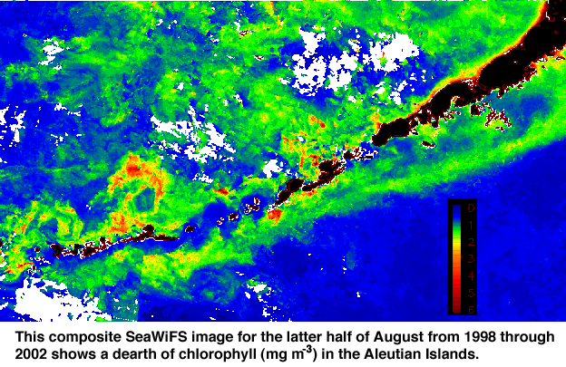
Customers: FOCI has an 18-year history of working with customers within and outside of NOAA. NOAA's Alaska Fisheries Science Center is engaged in management activities to insure that current groundfish fisheries are not adversely affecting SSLs or impeding their recovery, and research activities to understand why the population continues to decline. The North Pacific Fisheries Management Council established its Sea Lion Committee in January 2001 to review scientific and commercial data and provide ecommendations for SSL protection measures. The Western Alaska Community Development Quota (CDQ) Program allocates a percentage of all Bering Sea and Aleutian Islands quotas for groundfish, prohibited species, halibut, and crab to eligible communities. Significance: The listing of the SSL as a threatened species under the Endangered Species Act in 1990 created new challenges for fisheries managers in the National Marine Fisheries Service and the North Pacific Fisheries Management Council. Managers must balance between two sometimes conflicting objectives: protecting and aiding the recovery of the SSL under the Endangered Species Act while at the same time providing for sustainable and economically viable fisheries under the Magnuson-Stevens Fishery Conservation and Management Act. Groundfish fisheries in the Gulf of Alaska, Bering Sea, and Aleutian Islands, some of the largest and most valuable in the world, operate in a large portion of the SSL's distribution and target some of the same species that form a large part of the SSL's diet. During the period that SSLs have been declining, there have been large changes in the climate of the North Pacific ocean that may have altered the distribution and recruitment of fish stocks upon which SSLs feed. Next Steps: Biological production in the Aleutian passes and Bering Sea is dependent on oceanic flow and mixing in the passes. A reduction of flow from the North Pacific into the Bering Sea would be detrimental to the ecosystems supported there, including SSL habitat. Data support the hypothesis that the position and strength of the Alaskan Stream determine the flow through the passes. Because the Alaska Stream is part of the sub-arctic gyre, it can be modified by climate. Our next steps are to investigate the relationships between climate and the strength of the gyre. A long-term effort to place instrumented moorings in the Gulf of Alaska and North Pacific Ocean is needed to characterize the dynamics of the sub-arctic gyre and Alaskan Stream. This effort will begin in 2003 with anticipated SSL research funds, but longer-term, larger-scale measurements are required to understand the full scope of climate impact on the North Pacific region.
|
About us | Research | Publications | Data | Theme pages | Infrastructure |
| US Department of Commerce | NOAA | OAR | PMEL Pacific Marine Environmental Laboratory NOAA /R/PMEL 7600 Sand Point Way NE Seattle, WA 98115 |
Phone: (206) 526-6239 Fax: (206) 526-6815 Contacts Privacy Policy | Disclaimer | Accessibility Statement | oar.pmel.webmaster@noaa.gov |
|

 Mitigation
activities will focus on: 1) designation of 25% of communities at risk
in each state as TsunamiReady,
2) ensuring that public information is available at all beach access points,
evacuation procedures and maps are in all coastal jurisdiction telephone
books/utility bills/school sites/hotels, and education posters are in
75% of coastal water oriented/recreation businesses, 3) development of
approved engineering guidance in the FEMA Coastal Construction Manual
that addresses both high seismic and tsunami loading for use in new construction
and retrofitting of existing structures, 4) using social science tools
to measure tsunami resistance of communities and the effectiveness of
the NTHMP, 5) convincing 25% of the potentially threatened businesses
to include tsunami components in their business continuity plans, and
6) ensuring that the Federal Response Plan (FRP) comprehensively addresses
tsunami response and recovery.
Mitigation
activities will focus on: 1) designation of 25% of communities at risk
in each state as TsunamiReady,
2) ensuring that public information is available at all beach access points,
evacuation procedures and maps are in all coastal jurisdiction telephone
books/utility bills/school sites/hotels, and education posters are in
75% of coastal water oriented/recreation businesses, 3) development of
approved engineering guidance in the FEMA Coastal Construction Manual
that addresses both high seismic and tsunami loading for use in new construction
and retrofitting of existing structures, 4) using social science tools
to measure tsunami resistance of communities and the effectiveness of
the NTHMP, 5) convincing 25% of the potentially threatened businesses
to include tsunami components in their business continuity plans, and
6) ensuring that the Federal Response Plan (FRP) comprehensively addresses
tsunami response and recovery.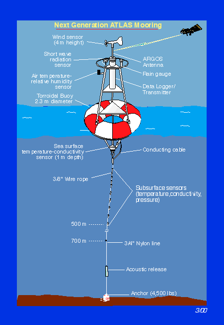

 xtensive
water column surveys from the Oregon State University
xtensive
water column surveys from the Oregon State University  Purpose: The western population of
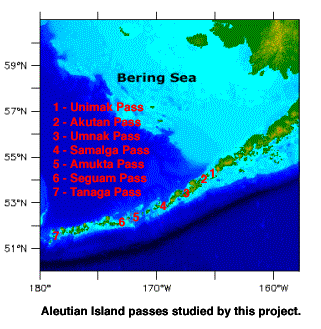
