|
Product Description |
|
||||||||||||||||||||||||||||||||||||||||||||||||||||||||||||||||||||||||||||||||||||||||||||||||||||||||||||||||||
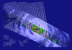
| Quikscat and TRMM measurements over Hurricane Floyd on September 13, 1999. | |||||||||||||||||||||||||||||||||||||||||||||||||||||||||||||||||||||||||||||||||||||||||||||||||||||||||||||||||||
Satellite surface wind data are obtained from Remote Sensing Systems (RSS) under the DISCOVER project: Distributed Information Services: Climate/Ocean Products and Visualizations for Earth Research (http://www.discover-earth.org/index.html). RSS uses a more accurate sea-surface emissivity model resulting in much better consistency between wind speed retrievals from microwave radiometers (SSM/I, AMSR, TMI) and those from scatterometers (NSCAT and SeaWinds). All observations are referenced to a height of 10 meters. |
|||||||||||||||||||||||||||||||||||||||||||||||||||||||||||||||||||||||||||||||||||||||||||||||||||||||||||||||||||
| |||||||||||||||||||||||||||||||||||||||||||||||||||||||||||||||||||||||||||||||||||||||||||||||||||||||||||||||||||
| Back to top | |||||||||||||||||||||||||||||||||||||||||||||||||||||||||||||||||||||||||||||||||||||||||||||||||||||||||||||||||||
Announcements |
|||||||||||||||||||||||||||||||||||||||||||||||||||||||||||||||||||||||||||||||||||||||||||||||||||||||||||||||||||
| Back to top | |||||||||||||||||||||||||||||||||||||||||||||||||||||||||||||||||||||||||||||||||||||||||||||||||||||||||||||||||||
Citations/References Hoffman, R. N.s, 1984: SASS wind ambiguity removal by direct minimization. Part II: Use of smoothness and dynamical constraints. Mon. Wea.Rev., 112, 1829–1852. |
|||||||||||||||||||||||||||||||||||||||||||||||||||||||||||||||||||||||||||||||||||||||||||||||||||||||||||||||||||
| Back to top | |||||||||||||||||||||||||||||||||||||||||||||||||||||||||||||||||||||||||||||||||||||||||||||||||||||||||||||||||||
| Related Publications Atlas R., S. C. Bloom, R. N. Hoffman, J. V. Ardizzone, and G. Brin, 1991: Space-Based Surface Wind Vectors to Aid Understanding of Air-Sea Interactions. EOS, 72, 201-208. Atlas R., R. W. Hoffman, and S. C. Bloom, 1993: Surface Wind Velocity Over the Oceans. Atlas of Satellite Observations Related to Global Change Atlas, 129-139. Atlas R., R., S. C. Bloom, R. N. Hoffman, E.Brin, J. Ardizzone, J. Terry, D.Bungato, and J. C. Jusem, 1999: Geophysical validation of NSCAT winds using atmospheric data and analyses. JGR., 104, 11405-11424. Atlas R., R., and R. N. Hoffman, 1999: The use of satellite surface wind data to improve weather analysis and forecasting. Satellites, Oceanography, and Society. Henderson, J. M., R. N. Hoffman, S. M. Leidner, J. V. Ardizzone, R. Atlas, and E. Brin, 2003: A comparison of a two-dimensional variational analysis method and a median filter for NSCAT ambiguity removal. J. Geophys. Res., 108, NO. C6, 3176, doi:10.1029/2002JC001307. Hoffman, R. N., S. M. Leidner, J. M. Henderson, R. Atlas, J. V. Ardizzone, and S. C. Bloom, 2003: A two-dimensional variational analysis method for NSCAT ambiguity removal: Methodology, sensitivity, and tuning. J. Atmospheric Oceanic Technology, 20, 585-605. Hoffman, R.N. and C. Grassotti, 1996: A technique for assimilating SSM/I observations of marine atmospheric storms. J. Applied. Meteorol., 35(8), 1177-1188. Uppala, S.M., and Coauthors, 2005: The ERA-40 Re-analysis. Quart. J. Roy. Meteor. Soc., 131, 2961-3012. |
|||||||||||||||||||||||||||||||||||||||||||||||||||||||||||||||||||||||||||||||||||||||||||||||||||||||||||||||||||
| Back to top | |||||||||||||||||||||||||||||||||||||||||||||||||||||||||||||||||||||||||||||||||||||||||||||||||||||||||||||||||||
User Services: podaac@podaac.jpl.nasa.gov |
|||||
All users publishing with PO.DAAC data from our providers & partners, please add a citation as outlined here. |
|||||


