
Public GIS Viewers (Maps)
The Railroad Commission of Texas has two ways for you to view oil, gas, and pipeline data in a map view.
Enhanced Public GIS Viewer
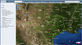
This enhanced Public GIS Viewer provides modernized functionality with improved searching and navigating through the Railroad Commission’s GIS database, as well as providing nine distinct and up-to-date basemap layer options which include streets, aerial imagery, and others. Enhanced printing and address location are also now available with the new viewer. Survey & Pipeline searches will be added in future releases of the viewer. The legacy GIS Viewer will remain until all search functionality has been added to the new viewer.
Launch Enhanced Public GIS Viewer
* Best viewed with Mozilla Firefox. Internet Explorer 9.0 and below are not recommended.
Legacy Public GIS Viewer

This geographic information system combines detailed information and location coordinates for oil wells, gas wells, and pipelines from the Commission's files with base map data captured from U.S. Geological Survey 7.5 minute quadrangle maps. These interactive maps were developed using Environmental Systems Research Institute, Inc. (ESRI) ArcIMS software, and interface with the Commission's Production Data Query and Drilling Permit Query applications.
Launch Legacy Public GIS Map Viewer
The database accessed by the Public GIS viewers is updated nightly. This database contains information on GIS layers, such as wells and pipelines.
Finding Data
To find information on Oil/Gas wells:
- Enter the API number 295-32952 in the SEARCH BY: Wellbore API Number of the Public Viewer.
- Then Selecting "Identify Well" from the Map Tools pull-down menu and clicking on the well shown on the map.
- At the "GIS WELLBORE ATTRIBUTES" that comes up, you will click on "Operator/Wellbore/PDQ".
- From the next window titled "OPERATOR/WELLBORE" you may access the Imaged documents by clicking on "Oil/Gas Imaged Records for API: 295-32952" or clicking on "Oil/Gas Imaged Records for Lease/ID: 214676"
To search for a pipeline:
The Pipeline Query is still available in the Legacy GIS Viewer.
- Click on the Pipeline button
- In the new window, set your criteria for your search
- Click on Query
- To locate the pipeline on the map, be sure you have the county selected, then click on Map The Results
For additional information please look in the Help instructions.
Notice/Disclaimer
The following data sets were generated from the Geographic Information System of the Railroad Commission of Texas.
- Base map information was obtained from U.S. Geological Survey 7.5 minute quadrangle maps.
- Patent Survey lines from Texas General Land Office maps were interpreted onto the U.S. Geological Survey base.
- Oil and gas well data and pipeline data were obtained from public records at the Railroad Commission of Texas (the Commission).
The data sets provided by this system are continually being updated and refined and are intended solely for the internal use of the Commission. The Commission shall not be held liable for use of these data sets, which are provided as a public service for informational purposes only. PLEASE NOTE that these data sets are NOT intended to be used as an authoritative public record for any geographic location or as a legal document and have no legal force or effect. Users are responsible for checking the accuracy, completeness, currency and/or suitability of these data sets themselves. The Commission makes no representation, guarantee or warranty as to the accuracy, completeness, currency or suitability of these data sets, which are provided 'AS IS'. The Commission specifically disclaims any and all warranties, representations or endorsements, express or implied, with regard to these data sets, including, but not limited to, the warranties of merchantability, fitness for a particular purpose, or non-infringement of privately owned rights.
Browser and Other Usage Requirements
The Public GIS Map Viewers are best viewed with Mozilla Firefox. Internet Explorer 9.0 and below are not recommended. All browsers must have JavaScript enabled.
Also, the Public GIS Map Viewer uses pop-up windows to display details on mapped wells and pipelines. Please disable pop-up blocking software while using this viewer. If you are not sure if pop-up blocking is enabled on your computer, please try our Pop-up Blocker Test.
System usage instructions and a Frequently Asked Questions section are available. Select the Help button within the Public GIS Map Viewer to display these instructions while you work with the maps.
Well Logs in TIFF File Format
For improved resolution, RRC’s well log files are stored and delivered in an image file format called "TIFF". If you do not have graphics-editing software capable of displaying TIFF files, you must install and use a browser plug-in -- similar to those required to access Adobe® PDF files, RealPlayer®, or Macromedia Flash® files -- on your workstation in order to view these files directly. Please consult the Public GIS Viewer Help file for more information on browser plug-ins for viewing TIFF files.
Contact Information
- Well Information - Contact rrc.mapping@rrc.texas.gov
- Pipeline Information - Contact tpms@rrc.texas.gov
- Technical Information - Contact RRC HelpDesk
- Operator Cleanup Program - Contact Aimee.Beveridge@rrc.texas.gov
ADA and Section 508 Compliancy for the Public GIS Viewers
At present, the accessibility of GIS in compliance with ADA and Section 508 is quite limited. The inherent graphical nature of GIS and the volumes of data represented make such compliance more difficult. The RRC's Public GIS Map Viewer uses software written by ESRI, which currently does not meet the ADA and Section 508 accessibility requirements. ESRI has stated its commitment to meet the requirements and goals of Section 508 and continues to test its products for compliancy. The Railroad Commission of Texas will continue to monitor the issues of GIS and ADA compliancy and the activity of GIS product vendors to meet state and federal accessibility requirements.
If you use assistive technology and the format of these pages prevents you from obtaining necessary data, please contact us. We will provide well and pipeline information and location data from the Public GIS Map Viewer. For data assistance, please contact our Electronic Data Coordinator, Ernest Oviedo. You may also contact the RRC Web Administrator for other technical assistance.
Last Updated: 9/29/2014 10:01:34 AM


