
Multimedia Gallery
Images Carousel
Images
Explore our planet through photography and imagery, including climate change and water all the way back to the 1800s when the USGS was surveying the country by horse and buggy.

Photographs from a red wolf (Canis rufus) found dead in North Carolina
Photographs from a red wolf (Canis rufus) found dead in North Carolina, USA. (A) Adult heartworms (Dirolfilaria immitis) in the right ventricle and atria of the heart and extending into the pulmonary artery. (B) Hard, haired nodule on the medial surface of the distal radius of the right leg. (C) Bilaterally symmetric bony proliferative lesions on the
...
Halema‘uma‘u lava lake - 01/18/2021
A close up of the southwest portion of the lava lake within Halema‘uma‘u, just south of the west fissure. The lava lake at Kīlauea's summit is perched, and is contained by a steep levee 2-3 meters (yards) high. USGS photo by M. Patrick.

Recent change in Halema‘uma‘u vent configuration - 01/18/2021
A close up of the vent area at the western fissure within Halema‘uma‘u at Kīlauea's summit. The two main vents were exhibiting low fountaining while a small vent in the middle had sporadic, weak spattering. USGS photo by M. Patrick.

Recent change in Halema‘uma‘u vent configuration - 01/18/2021
On the evening of January 17, the vent on the north side of the western fissure in Halema‘uma‘u at Kīlauea's summit activated and seemed to become the dominant vent overnight. This vent is the one on the right in this photo. The vent on the left, which was the dominant vent over the past week, seemed less energetic today. USGS photo by M. Patrick.
Low fountaining continues at the western fissure in Kīlauea's summit
Low fountaining continues at the western fissure, supplying lava to the lava lake in Halema‘uma‘u crater, at the summit of Kīlauea. The vent has formed a spatter cone around the fountaining, with lava spilling into an open channel that plunges into the lake. HVO scientists continue to monitor the eruption from within an area of Hawai‘i Volcanoes National Park that remains
...
Low fountaining continues at the western fissure in Kīlauea's summit
A closer view of the low fountaining at the western fissure in Halema‘uma‘u at Kīlauea's summit. The rim of the cone is built from accumulated deposits of spatter, and large chunks of the cone rim were observed to collapse from time to time. USGS photo by M. Patrick

Low fountaining continues at the western fissure in Kīlauea's summit
Sunlight interacts with volcanic gas from Kīlauea's summit lava lake and western fissure in this late afternoon view. The western fissure has built a spatter cone on the steep walls of Halema‘uma‘u, with lava spilling into the active lake, which forms the lower right portion of the photo. The remnants of Crater Rim Drive, which collapsed during the 2018 eruption, can be
...
Rhyolite alteration viewed by a Scanning Electron Microscope
Photos from a Scanning Electron Microscope (SEM) showing reacted rhyolite fragments at the end of the laboratory experiments. (a) Image magnified by 500 times showing the rhyolite after it reacted with water at 250 degrees Celsius (482 F). The reacted rhyolite fragments show very little change compared with the unreacted fragments. (b) Image magnified by 300 times showing
...
Instructions: How to Attend Virtual USGS Public Lecture
Instructions on How to Attend Virtual USGS Public Lecture
Mac:
1. Click on the Live Event link
within your email invitation to
launch Microsoft Teams.
2. Select "Cancel" if you see this
notification.
3. Click on "Watch on the
web instead” to view the

Steam vents along the Yellowstone River near Mud Volcano thermal area
Steam vents along the Yellowstone River near Mud Volcano thermal area, Yellowstone National Park.
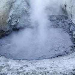
Mudpot located near Mud Volcano in Yellowstone National Park
Mudpot located in the Mud Volcano thermal area of Yellowstone National Park. This type of thermal feature indicates an acid-sulfate system.

Drilling through Ice
Drilling through ice on the Green River.

Average measurements of SO2 from Kilauea summit since 21 December 2020
Sulfur dioxide (SO2) emission rates measured using an upward-looking ultraviolet spectrometer. These data are collected by traversing the gas plume in a vehicle or helicopter, downwind of Halema‘uma‘u, generally within and/or southwest of Kīlauea caldera. Results from multiple traverses during a collection period are averaged to yield the
...
Evening view of Halema‘uma‘u lava lake, Saturday, January 9, 2021
The arrival of nightfall at Halema‘uma‘u on January 9, 2021, provided a clearer view of ongoing eruptive activity for USGS scientists monitoring the eruption this Saturday evening. This photo is focused on areas of active crustal motion in the western half of the lava lake; the eastern half (off to the right) is mostly stagnated and displays significantly less
...
Dusk view of Halema‘uma‘u lava lake, Saturday, January 9, 2021
Around sunset on Saturday (January 9, 2021), a break in the rain allowed HVO scientists to visit and monitor the ongoing eruption in Halema‘uma‘u. The west vent is still actively effusing lava, but outflow into the lava lake is increasingly sluggish, as evidenced by slow-moving crustal plates near the once-vigorous vent outlet. Also, much of the crust in the eastern half
...
Crustal Overturning (4x speed of original video)
This animated GIF was created from a clip within the original video showing crustal overturning at Kīlauea Volcano in Hawaii. The original video was at 20x the speed of the event, and this animation 4x faster.

Crustal Overturning (4x speed of original video)
This animated GIF was created from a clip within the original video showing crustal overturning at Kīlauea Volcano in Hawaii. The original video was at 20x the speed of the event, and this animation 4x faster.

Halema‘uma‘u just after sunset on January 8, 2021
Kīlauea’s summit lava lake, in Halema‘uma‘u, just after sunset on January 8, 2021. This view is to the north, from the south rim of the crater. HVO scientists continue to monitor the eruption within an area of Hawai‘i Volcanoes National Park that remains closed to the public for safety reasons. USGS image by N. Deligne.

Irrigated Land Use, Adelaida Area, San Luis Obispo County, CA
Irrigated land-use in the Adelaida Area of San Luis Obisbo County, CA for 1984, 1996, 2004, and 2014. Numbers indicate acres and percent of total acres. Source: California Department of Conservation Farmland Mapping and Monitoring Program,
...
Land Use (1996 and 2014), San Luis Obisbo County, CA
Land-use surveys of the Adelaida Area of San Luis Obisbo County, CA for 1996 and 2014. Numbers indicate acres and percent of total acres. Source: California Department of Water Resources,
...
Thermal image of the lava lake at the summit of Kīlauea - Jan. 7, 2021
This thermal image, looking northwest, shows the distribution of activity on the lava lake at Kīlauea's summit. The lake is slightly perched and surrounded along its perimeter by a lower ledge of cooler lava. The western fissure, in the wall of Halema‘uma‘u crater, is visible in the upper left portion of the image, just above the lake. Today, the eastern end of the lake (
...
Islands in Halemaumau and Kilauea Volcano lava lake, 1917 & 2021
Islands have been observed in Kīlauea lava lakes for more than 100 years—some move and some are moored. These two photographs of Halemaʻumaʻu crater from 1917 (top) and 2021 (bottom) show islands floating in lava lakes. The 1917 photographic panorama was taken from the edge of the lava lake, which was only about 30 m (100 ft) below crater rim and Kīlauea caldera floor. At
...
Kīlauea summit aerial imagery - January 7, 2021
This photo, taken during an overflight of Kīlauea's summit this morning (January 7, 2021), shows the southeast margin of Halemaʻumaʻu's growing lava lake. The photo shows the boundary between the active portion of the lava lake (left) and the subtle levee around the lake perimeter that allows the lake to be slightly perched. The photo shows that a margin around the lake (
...
Kīlauea summit aerial imagery - January 7, 2021
Aerial image of the active west vent area and the largest island in Halemaʻumaʻu's growing lava lake. During the overflight of Kīlauea's summit today (January 7, 2021) at approximately 10:30 a.m. HST, HVO geologists noted that the dome fountain, which had been persistent near the base of the west vent area, had subsided and was no longer present. USGS photo by K. Mulliken
...
Kīlauea summit aerial imagery - January 7, 2021
During an overflight of Kīlauea summit today (January 7, 2021) at approximately 10:30 a.m. HST, HVO geologists captured this image of the growing lava lake within Halemaʻumaʻu. Sunny weather allowed for clear views of Mauna Loa, to the west. USGS photo by M. Patrick.

Average measurements of SO2 from Kilauea summit in the past month
Sulfur dioxide (SO2) emission rates measured using an upward-looking ultraviolet spectrometer. These data are collected by traversing the gas plume in a vehicle or helicopter, downwind of Halema‘uma‘u, generally within and/or southwest of Kīlauea caldera. Results from multiple traverses during a day are averaged to yield the emission rates shown
...
Rainbow over the western fissure erupting in Halemaʻumaʻu crater
View to the north-northwest from the south rim of Halemaʻumaʻu crater and showing the activity at the western fissure, partly obscured by a rainbow. Today, the western fissure was erupting periodic small spatter bursts from the southwest vent of the fissure that is incandescent in this image and nearly as tall as the previously active cone to the right (northeast). Today,
...
HVO geologist measures lava lake features with a laser rangefinder
An HVO geologist takes Kīlauea summit eruption lake-level, spatter-cone, and dome-fountain measurements with a laser rangefinder. The top of the dome fountain in Halemaʻumaʻu was up to 5 meters (16 ft) above the lake surface. The lake elevation suggests a maximum lava lake depth of approximately 193 m (211 yd). HVO scientists monitor the ongoing Kīlauea summit eruption
...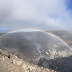
Double rainbow extending over the lava lake in Halemaʻumaʻu crater
View to the northwest from the south rim of Halemaʻumaʻu crater showing the lava lake in Halemaʻumaʻu at Kīlauea Volcano's summit. The active western fissure is visible above the lake, producing minor spatter and a gas plume from vents at the top. This vent is also sending lava into the lake from a lava tube opening at the lake surface, and producing a small dome fountain
...
January 5, 2021—Kīlauea summit eruption thermal map
A helicopter overflight on January 5, 2021, at approximately 8:30 a.m. HST allowed for aerial visual and thermal imagery to be collected of the eruption within Halema'uma'u crater at the summit of Kīlauea Volcano. The dimensions of the lava lake are 760 m (831 yd) E-W axis and 470 m (514 yd) in N-S axis. The most recent estimate of lake area is about 28 hectares (69 acres
...
thumbnail Katzner, et al. 2020 Publication Brief
Thumbnail image of plain language summary of:
Katzner, T.E., Braham, M.A., Conkling, T.J., Diffendorfer, J.E., Duerr, A.E., Loss, S.R., Nelson, D.M., Vander Zanden, H.B., Yee, J.L., 2020, Assessing population-level consequences of anthropogenic stressors for terrestrial wildlife: Ecosphere, v. 11, no. 3, p. e03046, https
...
Western North Slope Foothills
Geologist hikes across folded Cretaceous rocks in the central North Slope. These rocks were assessed by the USGS in 2017 and lie above the rocks assessed in the USGS 2021 Western North Slope assessment.

Western North Slope Foothills
The Kukpowruk River cuts through folded Cretaceous rocks in the central North Slope. These rocks were assessed by the USGS in 2017 and lie above the rocks assessed in the USGS 2021 Western North Slope assessment.

Tingmerkpuk Ridges
Jurassic rocks exposed in thurst-faulted structures near the southern limit of Western North Slope. In the subsurface farther north, these rocks may be reservoir rocks for natural gas.

red-tailed hawk population heat map
Figure 4 from Katzner, et. al., 2020

KW webcam image taken January 6, 2021, just after 6:30 a.m. HST.
Kīlauea summit KW webam image taken on January 6, 2021, just after 6:30 a.m. HST. The eruption in Halemaʻumaʻu continues and this photo shows that activity remains focused at the west vent as of Jan. 6 morning. You can view live KW webcam images here. USGS
...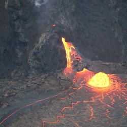
Halema‘uma‘u west vent activity for the evening of 5 January, 2021
Telephoto view of the lava flow and “dome fountain” activity at the west vent of the ongoing eruption in Halema‘uma‘u, Kīlauea Volcano summit, at 5:45 p.m. HST on 5 January, 2021. USGS photo by K. Lynn.

Halema‘uma‘u lava lake on the evening of 5 January, 2021
View looking north across Kīlauea caldera from the south rim of Halema‘uma‘u, showing the ongoing eruption around 5:30 p.m. HST on January 5, 2021. The west vent activity included the “dome fountain,” effusive lava flows from a mid-elevation vent, and weak strombolian spattering activity from the high-elevation vent. USGS photo by K. Lynn.

Kīlauea west vent “dome fountain” activity for 5 January, 2021
View through the laser rangefinder from the south rim of Halema‘uma‘u, Kīlauea Volcano summit, and showing the “dome fountain” and west vent effusive lava flow around 3:30 p.m. HST on January 5, 2021. A glowing vent is also visible at the top of the spatter structure. USGS photo by K. Lynn.

January 5, 2021—Kīlauea summit topographic changes
Topography of Halema'uma'u crater, at the summit of Kīlauea Volcano, on December 26, 2020 (left), and January 5, 2021 (right). These Digital Elevation Models (DEMs) are created from aerial imagery collected during helicopter overflights. They show that the lava lake within Halema'uma'u continues to rise and deepen. Eruptive vents are evident on the wall of Halema'uma'u,
...
January 4, 2021, Below Normal Groundwater Levels Network
Map indicates groundwater sites within the USGS Active Groundwater Level network where the most recent groundwater-level measurement is in the 24th percentile or lower in the month of measurement over the period of record for the well. For more information about what wells are included or to view data, visit the Below
...
Channel crusting over at the base Halema'uma'u's west vent
The west vent in Halema‘uma‘u crater continues to erupt at Kīlauea’s summit. These telephoto images from December 29 (left) and December 30 (right) compare the lava lake surface below the west vent. The west vent is supplying lava to the lake through a crusted over channel, which was starting to form by December 30. USGS photos by H. Dietterich.

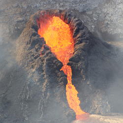
Kīlauea summit eruption - Jan. 3, 2020, at 1:30 a.m. HST
At Halema‘uma‘u, the west vents (visible in the foreground of this photo as two glowing holes on a cone-shaped feature) erupt occaisional spatter. Lava is also emerging in a small dome fountain above the lake crust in front of the west vents, probably from a submerged portion of the vent (visible in the background of this photo as a bright spot with lava crust boundaries
...
Kīlauea summit eruption - Jan. 3, 2020, at 1:30 a.m. HST
Early this morning, the west vents in Halema‘uma‘u spattered from two places at the top of a small cone plastered on the northwest wall. This process can be seen in Kīlauea Volcano's summit F1 thermal webcam view of the lava lake. USGS photo by H.
...
Kīlauea summit eruption - Jan. 2, 2021, at 7:30 a.m. HST
Telephoto photograph of the west vent area and lava lake in Halema‘uma‘u, at Kīlauea Volcano's summit. USGS photo by K. Lynn.

Kīlauea summit eruption - Jan. 2, 2021, at 7 a.m. HST
View of the west vent area and lava lake in Halema‘uma‘u, at Kīlauea Volcano's summit. USGS photo by K. Lynn.
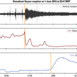
Steamboat Geyser eruption signals
Steamboat Geyser eruption signals recorded by nearby monitoring instruments. The vertical pink lines mark when the signal first appears. (A) Seismic station YNM records a signal which slowly tapers as the eruption decreases in intensity. Spikes seen before the eruption are mostly due to human activity. (B) Moments before a major eruption begins, there is often a surge of
...
Eruptions of Steamboat Geyser over time
Eruptions of Steamboat Geyser over time. (A) Cumulative eruptions of Steamboat Geyser since 1960. Each dot represents an eruption. (B) Comparative plot of the cumulative eruptions in each active phase (1960s, 1980s, and 2018-). Data from GeyserTimes. Note that some eruptions in the 1960s are missing from this
...