Ocean Images
A gallery of great images of our ocean and coasts.
Latest Photos:

In Washington State, the Shoalwater Bay Indian Tribe and North Cove community led a vigorous local effort to find effective treatments for severe shoreline erosion along Willapa Bay. Their determination is starting to pay off in pilot projects that are halting erosion in its tracks via rebuilt dunes and the placement of cobble berms—called “dynamic revetments”—along the shoreline. The Washington Coastal Zone Management Program provided award-winning technical and monitoring assistance and worked to secure grants, one supported by NOAA’s Office for Coastal Management.
In this photo, Washington Department of Ecology’s Environmental Specialist, Amanda Hacking, and Coastal Engineer, George Kaminsky, track tagged cobbles along the dynamic revetment. Image credit: Washington Department of Ecology
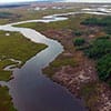
An aerial view of the Little Monie Creek component of Chesapeake Bay Maryland National Estuarine Research Reserve. Staff were observing their migrating marshes during this fly-over. Photo credit: Coreen Weilminster

Egrets roost in a small hummock in Assateague Bay — the small islands within Chesapeake Bay Maryland National Estuarine Research Reserve are vital habitat for the nesting migrants. Photo credit: Coreen Weilminster

This diver is embarking on an underwater adventure at Flower Garden Banks National Marine Sanctuary. NOAA sanctuaries and reserves are protected areas that help us conserve these special coastal and marine places for future generations. Diving is just one of many recreational opportunities available at these sites.

This image shows the view from the M/V Ocean Wind as the ship transits down the Mississippi River. More than 10,000 ships pass through the port complexes between New Orleans to Baton Rouge each year. This region is the most congested waterway in the world. NOAA's Office of Coast Survey plans to begin surveying the Mississippi River in 2018 to update nautical charts.

NOAA's navigation response teams (NRT) conduct hydrographic surveys to update NOAA’s suite of nautical charts. The teams are strategically located around the country and remain on call to respond to emergencies speeding the resumption of shipping after storms, and protecting life and property from underwater dangers to navigation. Five new NRT boats, including the one shown here, were procured over a three-year period with the final boat built in 2017.

Have you ever heard of a crinoid? They’re marine animals related to sea stars and sea urchins. Divers snapped this colorful crinoid in a coral reef in the Northern Mariana Islands. If you like this photo, head over to the NOAA Coral Reef Conservation Program image gallery for more breathtaking imagery.

On February 9, 2018, the NOAA Central Library unveiled the newly restored painting, Pathfinder, painted in 1899 by renowned maritime artist, Antonio Jacobsen. Included as part of the NOAA Central Library Rare Books collection, the painting is the oldest extant painting of a NOAA ancestor ship in the possession of NOAA.
The Pathfinder vessel was one of the U.S. Coast and Geodetic Survey’s early ships, in service from 1899-1941. The history of the Pathfinder is unique, as its career spanned 40 years charting Philippine waters before its loss in the early days of World War II. In addition to helping open the Philippine Islands to then modern ship-borne commerce, its pre-war work was instrumental for both strategic and tactical purposes in the retaking of the Philippine Islands during World War II.
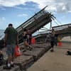
On November 16, 2017, volunteers at Mission-Aransas National Estuarine Research Reserve in Texas cleaned up debris washed between the rocks in a jetty following Hurricane Harvey. The jetty shown here lines Aransas Pass, where oil tankers pass through to Corpus Christi Bay. The damage to the pier in the background was not caused by wind. It sustained damage from an oil tanker that was beached during the hurricane and broke free after the storm passed. The crew is cleaning up debris that washed between the rocks in the jetty during Harvey.

On November 16, 2017, volunteers replaced pea gravel blown away during Hurricane Harvey on the trail at the Wetland Education Center at Mission-Aransas National Estuarine Research Reserve in Texas. The Wetland Education Center offers trails and interpretive signs that help educate visitors on the surrounding wetlands. Staff who remained on site during the hurricane said that pea gravel from the paths pelted buildings on the reserve "like thousands of bullets."

The South Haven, Michigan buoy, pictured here, was originally funded by the NOAA Coastal Storms Program to supply critical information to help keep beachgoers and recreational boaters safe along this popular Lake Michigan coastline. During the pilot program, the buoy’s observations often were used by NOAA’s National Weather Service office in Grand Rapids, which issued 60 small-craft warnings. Recognizing the buoy’s importance as part of a regional nearshore network, South Haven and community organizations secured the funds needed to support permanent buoy operation and maintenance. Credit: LimnoTech

Installation of a new microwave water level sensor at the NOAA station in Lime Tree Bay, Virgin Islands.

A NOAA field crew prepares a current meter mooring for deployment in Puget Sound, Washington.

Staff install the final components on the NOAA water level station on the Chesapeake Bay Bridge Tunnel, at the mouth of the bay.

A field crew performs routine maintenance at the NOAA water level station at Coyote Creek, California. This station, located on the south shore of the San Francisco Bay, is a partnership with the Santa Clara Valley Water District and the U.S. Fish and Wildlife Service.

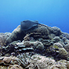
An octopus camouflages itself in corals along the coast of Asuncion Island in the Commonwealth of the Northern Mariana Islands.

A blunt slipper lobster (Scyllarides squammosus) patrols a busy coral reef habitat of massive Porites and encrusting Monitpora corals off the coast of Moloka‘i in the main Hawaiian Islands.

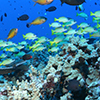
Corals are home to millions of species. Humbug dascyllus (Dascyllus aruanus) and multibar goatfish (Parupeneus multifasciatus) are commonly seen in the shallow reefs and lagoons of American Samoa.

A sea anemone surrounded by Pocillopora, Porites, and giant clams at Kingman Reef in the Pacific Remote Islands Marine National Monument.

Close-up shot of a slate pencil urchin (Heterocentrotus mamillatus) at Kingman Reef in the Pacific Remote Islands Marine National Monument.

The coral reef benthic community at Swains Island in American Samoa is dominated by an assemblage of plating Montipora and branching Pocillopora meandrina.

Grey reef sharks and colorful schools of anthias in the waters of Jarvis Island, Pacific Remote Island Areas Marine National Monument. Credit: Kelvin Gorospe

The Center for Operational Oceanographic Products and Services, in partnership with the Integrated Ocean Observing System (IOOS®), has established a new Physical Oceanographic Real Time System (PORTS®) in Cape Cod. A high tech wave-monitoring buoy was recently deployed in Cape Cod Bay that will provide ocean information to improve safety and efficiency of marine transportation as mariner’s approach or exit Cape Cod Canal. This buoy will also become part of the Northeastern Regional Association of Coastal Ocean Observing Systems buoy network. (Image courtesy of U.S. Geological Survey)

Students from Simon Sanchez High School view sedimentation in the Achang Marine Preserve after planting 1,000 acacia seedlings with the Guam Agriculture Department’s Forestry Division during an October 2015 restoration project in the Manell-Geus Habitat Focus Area. In the distance, a sediment plume is visible in the water after a storm.
The Manell-Geus watershed is a NOAA Habitat Blueprint site located in southern Guam. Habitat Blueprint is focused on improving habitat as a way to improve resilience to climate change impacts. From planting trees to stabilize soil to training people to monitor their coral reef resources, NOAA and Merizo residents are teaming up to support natural resource management to ensure strong fishing traditions and healthy reef habitats exist for years, and generations, to come.

The Geus River in the Manell-Geus watershed Habitat Focus Area is an important cultural, recreational, and subsistence area for many local residents. The area includes the island’s only shallow water lagoon, as well as fringing reefs, mangroves and extensive seagrass beds. It is also home to the coastal village of Merizo, which is well-known for its strong fishing tradition.

Priest Pools is a popular hiking spot for Merizo residents and visitors. It is located in the Manell-Geus watershed, a NOAA Habitat Blueprint site located in southern Guam. The area includes the island’s only shallow water lagoon, as well as fringing reefs, mangroves and extensive seagrass beds. It is also home to the coastal village of Merizo, which is well-known for its strong fishing tradition.

NOAA expanded its Physical Oceanographic Real-Time System (PORTS®) to Cleveland, Ohio, to aid navigation on the Cuyahoga River. The Cuyahoga River PORTS® current meter provides critical real time data that helps vessels safely transit iron ore upriver into Cleveland’s lakefront facilities.
A pink whipray (Himantura fai) glides over colonies of the branching coral Stylophora at Swains Island, American Samoa.

In May, the 2016 Northwestern Hawaiian Islands marine debris removal mission came to an end, successfully hauling in 12 tons of debris from Papahānaumokuākea Marine National Monument. A marine debris team of 10 NOAA scientists was part of the removal effort that spanned 32 days cleaning Midway Atoll National Wildlife Refuge, Pearl and Hermes Atoll, Kure Atoll State Wildlife Sanctuary, Lisianski Island, and the French Frigate Shoals. In this image, a Laysan Albatross looks curiously at a pile of disposable cigarette lighters. These were part of the 535 cigarette lighters collected during this year’s mission.
National marine sanctuaries and marine national monuments are places for great diversity of ocean life and this image doesn’t disappoint. Here Bluestripe snapper, Ta’ape, Threespot damselfish, and Oval Chromis damselfish are seen swimming around Lobe coral, Pohaku puna, and Table coral at French Frigate Shoals in the Papahānaumokuākea Marine National Monument. Credit: James Watt/NOAA

Children explore the Rachel Carson Reserve during a field trip with North Carolina National Estuarine Research Reserve staff. The North Carolina Reserve was established to preserve the fragile natural areas that make up the third largest estuarine system in the country and the variety of life found there. Credit: Emily Woodward

Close up of a Spanish Dancer nudibranch egg ribbon in Papahānaumokuākea Marine National Monument

Close up of a sea urchin at the Pearl and Hermes Atoll in the Papahānaumokuākea Marine National Monument

Close up of a crown-of-thorns starfish at Gardner Pinnacles in Papahānaumokuākea Marine National Monument

A juvenile threespot damselfish nestled in a pillar coral colony in St. Thomas, U.S. Virgin Islands. Pillar coral is listed as threatened under the Endangered Species Act.

A school of whitespotted surgeonfish (Acanthurus guttatus) pause their grazing for a moment before moving onto another suitable patch of reef in American Samoa.