
Unified Interior Regions
Region 11: Alaska
Alaska Science Center

4210 University Drive
Anchorage, AK 99508
Phone: (907) 786-7000
Volcano Science Center
4230 University Drive
Anchorage, AK 99508
Phone: (907) 786-7497
Climate Adaptation Science Center

4230 University Drive
Anchorage, AK 99508
Phone: 907-301-7830
Regions L2 Landing Page Tabs
USGS in Alaska conducts science for decision-making in five major areas: natural hazards; energy & minerals; water quality, streamflow & ice; wildlife, fish & habitat; and geospatial mapping. The Alaska Regional Office provides management and strategic coordination among the Alaska Science Center, the Volcano Science Center, the Climate Adaptation Science Center, & other partners operating in AK.
View Centers and ObservatoriesNews

ICYMI Bulletin: Community Voices: New Volcano Monitors Increase Safety
Originally Published by: The Daily News
By: U.S. Geological Survey Director James Reilly
This article has been reprinted or reproduced with the permission of the The Daily News in Longview WA.

Earth MRI Funds Critical Minerals Projects in Alaska
A total of $634,000 will fund new research and preserve important data across the Last Frontier.

USGS Science to Keep Us Safe: Floods and Drought
The scarcity or overabundance of water presents some of the most dangerous, damaging and costly threats to human life, ecosystems and property in the form of drought, floods and debris flows.
Publications

Coding-Complete Genome Sequence of Avian Orthoavulavirus 16, isolated from Emperor Goose (Anser canagica) feces, Alaska, USA
We sequenced the coding-complete genome of an avian orthoavulavirus serotype 16 (AOAV-16) isolate recovered from emperor goose (Anser canagicus) feces collected in Alaska. The detection of AOAV-16 in North America and genomic sequencing of the resultant isolate confirms that the geographic distribution of this virus extends beyond Asia.
Reeves, Andrew B.; Killian, Mary Lea; Tanner, Michael E; Lagasse, Benjamin Joel; Ramey, Andrew M.; Stallknecht, David E.; Poulson, Rebecca L. Evidence for continental-scale dispersal of antimicrobial resistant bacteria by landfill-foraging gulls
Anthropogenic inputs into the environment may serve as sources of antimicrobial resistant bacteria and alter the ecology and population dynamics of synanthropic wild animals by providing supplemental forage. In this study, we used a combination of phenotypic and genomic approaches to characterize antimicrobial resistant indicator bacteria, animal...
Ahlstrom, Christina; van Toor, Mariëlle L.; Woksepp, Hanna; Chandler, Jeffrey C; Reed, John; Reeves, Andrew B.; Waldenström, Jonas; Franklin, Alan B.; Douglas, David C.; Bonnedahl, Jonas; Ramey, Andrew M. Identification of seasonal streamflow regimes and streamflow drivers for daily and peak flows in Alaska
Alaska is among northern high‐latitude regions where accelerated climate change is expected to impact streamflow properties, including seasonality and primary flow drivers. Evaluating changes to streamflow, including flood characteristics, across this large and diverse environment can be improved by identifying the distribution and influence of...
Curran, Janet H.; Frances E. BilesUSGS in Alaska engages approximately 400 scientists and support staff working across 3 major centers with a combined annual science budget of about $65 million. In just the last 5 years, USGS in Alaska has produced scientific benefits resulting from over 1000 publications and about 250 Technical Reports.

Alaska North Slope LiDAR
High-resolution light detection and ranging (lidar) elevation data were acquired along the north coast of Alaska between 2009 and 2012. The lidar acquisition, from Icy Cape, Alaska to the United States/Canadian border, comprised approximately 11,000 km2. The airborne lidar data were acquired in support of the U.S. Geological Survey...

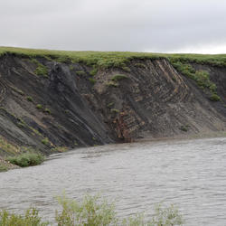
Climate impacts to Arctic coasts
The Arctic region is warming faster than anywhere else in the nation. Understanding the rates and causes of coastal change in Alaska is needed to identify and mitigate hazards that might affect people and animals that call Alaska home.

U.S. West Coast and Alaska Marine Geohazards
Marine geohazards are sudden and extreme events beneath the ocean that threaten coastal populations. Such underwater hazards include earthquakes, volcanic eruptions, landslides, and tsunamis.
Devastating earthquakes in Japan (2011) and Chile (2010) that spawned pan-oceanic tsunamis sent a sobering reminder that U.S. coastlines are also vulnerable to natural disasters that originate in...

Coastal Change Hazards
Natural processes such as waves, tides, and weather, continually change coastal landscapes. The integrity of coastal homes, businesses, and infrastructure can be threatened by hazards associated with event-driven changes, such as extreme storms and their impacts on beach and dune erosion, or longer-term, cumulative...

PCMSC Marine Facility (MarFac)
Learn about the USGS Pacific Coastal and Marine Science Center Marine Facility, or MarFac

Earthquake Hazards in Southeastern Alaska
Over the last 100 years, the Queen Charlotte-Fairweather fault system has produced large-magnitude earthquakes affecting both Canada and the U.S. To fill in missing details about its offshore location and structure, USGS uses sophisticated techniques to truly understand the fault’s hazard potential.

Tracking Data for Yellow-billed Loons (Gavia adamsii)
Available here are tracking data of Yellow-billed loons, a species that breeds in coastal areas of western and northern Alaska and adjacent regions of Russia and Canada. This species winters along the Pacific coasts of North America and Eurasia. These data were collected to better understand the patterns of migratory movements and seasonal use of different regions of Alaska

Assessment of Gas Hydrate Resources in the North Slope of Alaska, 2018
The U.S. Geological Survey (USGS) has updated the previous 2008 assessment of undiscovered, technically recoverable gas hydrate resources beneath the North Slope of Alaska. This new 2018 assessment again indicates the existence of technically recoverable gas hydrate resources―that is, resources that can be discovered, developed, and produced using current technology. Using a geology-based...

Alaska North Slope 2018 Hydrate 01 Stratigraphic Test Well
The National Energy Technology Laboratory (NETL), the Japan Oil, Gas and Metals National Corporation (JOGMEC), and the U.S. Geological Survey (USGS) are leading an effort to conduct an extended gas hydrate production test in northern Alaska.

M7.1 November 30, 2018 Anchorage Earthquake
A magnitude 7.1 earthquake struck north of Anchorage, Alaska, on November 30, 2018, at 8:29 a.m. local time (17:29:28 UTC).

Swan Research
USGS research on swans in Alaska has focused on pathogens, contaminants, and demographic rates in each of the different breeding areas of Alaska. The vastly different migration patterns of swans in Alaska means that there are multiple factors on the wintering grounds and during migration that may influence population size and trends.

Sitka, AK
On August 18, 2015, heavy rainfall triggered around 60 landslides in and around the city of Sitka, AK. The landslides moved downslope rapidly; several were damaging and one of these demolished a home on South Kramer Avenue killing three people.
USGS produces objective, high-quality data that is relevant to decision-makers, resource managers, the scientific community, and the public. Access digital datasets, climate data & analysis tools, interactive maps for volcanic activity, and more!
AK Minerals Resource Data File
Climate Data and Analysis Tools
Search USGS Science Data Catalog
Alaska IfSAR Elevation Data
Radar data is being collected statewide for Alaska under direction of the USGS 3D Elevation Program (3DEP). The new data is vastly improving the accuracy and resolution of elevation data for the state, and is being collected using an airborne Interferometric Synthetic Aperture Radar (IfSAR) sensor. USGS and the State of Alaska maintain web-based status maps and download services.

Elevation Data
The 3DEP products and services available through The National Map consist of lidar point clouds (LPC), standard digital elevation models (DEMs) at various horizontal resolutions, elevation source and associated datasets, an elevation point query service and bulk point query service. All 3DEP products are available, free of charge and without use restrictions.

Volcano Monitoring Data
Many volcanoes in the U.S. are monitored by arrays of several instruments that detect subtle movements within the earth and changes in gas and water chemistry. The Volcano Hazards Program streams this data to its Volcano Observatories and makes it available on volcano-specific websites.

Alaska Volcano Observatory Satellite Data
This is a new tool for understanding and communicating risks. The activities include the development of risk models and approaches to improve the situational awareness of communities and industries to natural hazards and reduce the uncertainty of those risk assessments.

Alaska Volcano Observatory - Is Ash Falling?
Reports of ash fall are important to us; we use your observations to assess the character and size of an eruption plume. We report these data to the National Weather Service so they can keep their Ashfall Advisories current. Additionally, reports of NO ashfall during an eruption with expected ashfall are also important to us.
The USGS is a world leader in producing and distributing maps and geospatial data, ranging from local to national and global scales. The Alaska Mapping Initiative supports the procurement of new topographic maps and data for the Alaska Region to levels commonly found in the rest of the contiguous United States. You can download Alaska US Topo maps for free here.
Alaska Geologic Map
All US and Foreign territory north of the Arctic Circle and all US terrritory north and west of the boundary formed by the Porcupine, Yukon, and Kuskokwim Rivers; all contiguous seas including the Arctic Ocean and the Beaufort, Bering and Chukchi Seas, and the Aleutian chain.

All US and Foreign territory north of the Arctic Circle and all US terrritory north and west of the boundary formed by the Porcupine, Yukon, and Kuskokwim Rivers; all contiguous seas including the Arctic Ocean and the Beaufort, Bering and Chukchi Seas, and the Aleutian chain.

Region: Alaska. All US and Foreign territory north of the Arctic Circle and all US terrritory north and west of the boundary formed by the Porcupine, Yukon, and Kuskokwim Rivers; all contiguous seas including the Arctic Ocean and the Beaufort, Bering and Chukchi Seas, and the Aleutian chain.

Alaska's north coast has been home to indigenous communities for centuries. Changing coastlines threaten important infrastructure and historic sites that support indigenous communities. Changing coastlines also can potentially reduce habitat for Arctic wildlife, such as polar bears, shorebirds, and walruses. Oil- and gas-related development sites and U.S. Department of Defense installations

This map shows the provinces assessed by the USGS for undiscovered oil and gas resources.

This is an interactive version of the Alaska geologic map database which allows a user to view and access many features of the database and map through a standard web browser. In other words, there is no need for or knowledge of specialized GIS software.
The 3DEP products and services available through The National Map consist of standard digital elevation models (DEMs) at various horizontal resolutions, elevation source and associated datasets, an elevation point query service and bulk point query service. All 3DEP products are available, free of charge and without use restrictions.

Links to publications that contain maps of the sea floor or lake beds and the digital data used to create them.

New US Topo maps for Alaska are being produced statewide, with digital 7.5 minute 1:25,000-scale maps providing a comprehensive update to the 15-minute 1:63,360-scale printed maps produced nearly fifty years ago. You can view a status map showing where the new maps are available, and link to a site to download the maps.

On March 27, 1964 the largest recorded earthquake in U.S. history struck southcentral Alaska. Click on the photos or the numbers to take a tour.
USGS research activities relevant to Alaska have yielded more than 9400 historical publications. This page features some of the most recent newsworthy research findings.
Search USGS publications for Alaska
Arctic Science for Decision Maker
2019 USGS Alaska Annual Science Report Coding-Complete Genome Sequence of Avian Orthoavulavirus 16, isolated from Emperor Goose (Anser canagica) feces, Alaska, USA
We sequenced the coding-complete genome of an avian orthoavulavirus serotype 16 (AOAV-16) isolate recovered from emperor goose (Anser canagicus) feces collected in Alaska. The detection of AOAV-16 in North America and genomic sequencing of the resultant isolate confirms that the geographic distribution of this virus extends beyond Asia.
Reeves, Andrew B.; Killian, Mary Lea; Tanner, Michael E; Lagasse, Benjamin Joel; Ramey, Andrew M.; Stallknecht, David E.; Poulson, Rebecca L. Evidence for continental-scale dispersal of antimicrobial resistant bacteria by landfill-foraging gulls
Anthropogenic inputs into the environment may serve as sources of antimicrobial resistant bacteria and alter the ecology and population dynamics of synanthropic wild animals by providing supplemental forage. In this study, we used a combination of phenotypic and genomic approaches to characterize antimicrobial resistant indicator bacteria, animal...
Ahlstrom, Christina; van Toor, Mariëlle L.; Woksepp, Hanna; Chandler, Jeffrey C; Reed, John; Reeves, Andrew B.; Waldenström, Jonas; Franklin, Alan B.; Douglas, David C.; Bonnedahl, Jonas; Ramey, Andrew M. Identification of seasonal streamflow regimes and streamflow drivers for daily and peak flows in Alaska
Alaska is among northern high‐latitude regions where accelerated climate change is expected to impact streamflow properties, including seasonality and primary flow drivers. Evaluating changes to streamflow, including flood characteristics, across this large and diverse environment can be improved by identifying the distribution and influence of...
Curran, Janet H.; Frances E. Biles Shifts in the wintering distribution and abundance of Emperor Geese in Alaska
For wildlife species that winter at northern latitudes, harsh overwinter conditions can play an important role in population dynamics. Recent changes in global temperatures have resulted in distributional shifts of wildlife species, as well as amelioration of winter climates in northern landscapes. The emperor goose (Anser canagicus), an endemic...
Uher-Koch, Brian D.; Buccheit, Raymond M.; Eldermire, Charles R.; Wilson, Heather M.; Schmutz, Joel A. Lake trout growth is sensitive to spring temperature in southwest Alaska lakes
In high‐latitude lakes, air temperature is an important driver of ice cover thickness and duration, which in turn influence water temperature and primary production supporting lake consumers and predators. In lieu of multidecadal observational records necessary to assess the response of lakes to long‐term warming, we used otolith‐based growth...
von Biela, Vanessa R.; Black, Bryan A.; Young, Daniel B.; van der Sleen, Peter; Bartz, Krista K.; Zimmerman, Christian E.
Changing storm conditions in response to projected 21st century climate change and the potential impact on an arctic barrier island–lagoon system—A pilot study for Arey Island and Lagoon, eastern Arctic Alaska
Executive SummaryArey Lagoon, located in eastern Arctic Alaska, supports a highly productive ecosystem, where soft substrate and coastal wet sedge fringing the shores are feeding grounds and nurseries for a variety of marine fish and waterfowl. The lagoon is partially protected from the direct onslaught of Arctic Ocean waves by a barrier island...
Erikson, Li H.; Gibbs, Ann E.; Richmond, Bruce M.; Storlazzi, Curt D.; Jones, Benjamin M.; Ohman, Karin
Alaska and Landsat
Alaska’s landscapes are changing at a more rapid rate than those of the lower 48. Its large size makes the collection of aerial surveys—a biannual occurrence for the conterminous United States—cost-prohibitive. That means the Landsat series of land imaging satellites offer the only publicly available, up-to-date imagery of land conditions for...
Permafrost mapping with electrical resistivity tomography in two wetland systems north of the Tanana River, Interior Alaska
Surface-based 2D electrical resistivity tomography (ERT) surveys were used to characterize permafrost distribution at wetland sites on the alluvial plain north of the Tanana River, 20 km southwest of Fairbanks, Alaska, in June and September 2014. The sites were part of an ecologically-sensitive research area characterizing biogeochemical response...
Conaway, Christopher H.; Johnson, Cordell; Lorenson, Thomas; Turetsky, Merritt R.; Euskirchen, Eugénie S.; Waldrop, Mark; Swarzenski, Peter W.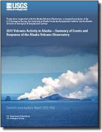
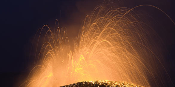
2017 Volcanic activity in Alaska—Summary of events and response of the Alaska Volcano Observatory
The Alaska Volcano Observatory responded to eruptions, significant and minor volcanic unrest, and seismic events at 16 volcanic centers in Alaska during 2017. The most notable volcanic activity consisted of a major eruption at Bogoslof Island, continuing intermittent dome growth and ash eruptions from Mount Cleveland, the end of the Pavlof Volcano...
Dixon, James P.; Cameron, Cheryl E.; Iezzi, Alexandra M.; Power, John A.; Wallace, Kristi L.; Waythomas, Christopher F.
2016 Volcanic activity in Alaska—Summary of events and response of the Alaska Volcano Observatory
The Alaska Volcano Observatory responded to eruptions, volcanic unrest or suspected unrest, and seismic events at 15 volcanic centers in Alaska during 2016. The most notable volcanic activity consisted of eruptions at Pavlof and Bogoslof volcanoes. Both eruptions produced significant ash clouds that affected regional air travel. Mount Cleveland...
Cameron, Cheryl E.; Dixon, James P.; Waythomas, Christopher F.; Iezzi, Alexandra M.; Wallace, Kristi L.; McGimsey, Robert G.; Bull, Katharine F. Permafrost promotes shallow groundwater flow and warmer headwater streams
The presence of permafrost influences the flow paths of water through Arctic landscapes and thereby has the potential to impact stream discharge and thermal regimes. Observations from eleven headwater streams in Alaska showed that July water temperatures were higher in catchments with more near‐surface permafrost. We apply a fully coupled...
Sjoberg, Ylva; Janke, Adam K.; Painter, S; Coonradt, E.; Carey, Michael P.; O'Donnell, Jonathan A.; Koch, Joshua C. Cretaceous to Oligocene magmatic and tectonic evolution of the western Alaska Range: insights from U-Pb and 40Ar/39Ar geochronology
New U-Pb and 40Ar/39Ar ages integrated with geologic mapping and observations across the western Alaska Range constrain the distribution and tectonic setting of Cretaceous to Oligocene magmatism along an evolving accretionary plate margin in south-central Alaska. These rocks were emplaced across basement domains that include Neoproterozoic to...
Jones, James V.; Todd, Erin; Box, Stephen E.; Haeussler, Peter; Holm-Denoma, Christopher; Karl, Susan M.; Graham, Garth E.; Bradley, Dwight C.; Kylander-Clark, Andrew R.C.; Friedman, Richard M.; Layer, Paul W.
This R script will run one example of the stochastic matrix models run by Weiser et al. (2020) to simulate shorebird populations. The model predicts population growth rates and elasticity values of vital rates. The example script is stand-alone and contains input values for one example species; input values for the other species are provided in the manuscript.

Bioinformatics software repository containing python scripts intended for search and download of genetic information obtained from GenBank NCBI genetics data resources in support of developing PCR primers, targeted genetic databases, genetic analyses, and data interpretation. Includes multiple functions to streamline this process.

Daily sea ice imagery and charting benefits logistics and navigational planning in the Alaskan Arctic waters, yet access to these data often requires high bandwidth data access and substantial GIS processing.
")
Cormack-Jolly-Seber (CJS) mark-recapture models are widely utilized in ecology, providing estimates of vital rates and abundance that are difficult to obtain using other means.

Quantitative fatty acid signature analysis (QFASA; Iverson et al. 2004) has become a common method of estimating diet composition, especially for marine mammals, but the performance of the method has received limited investigation.

The Pedestrian Evacuation Analyst is an ArcGIS extension that estimates how long it would take for someone to travel on foot out of a hazardous area that was threatened by a sudden event such as a tsunami, flash flood, or volcanic lahar. It takes into account the elevation changes and the different types of landcover that a person would encounter along the way.

Quantitative fatty acid signature analysis (QFASA) is a method of diet estimation introduced over a decade ago (Iverson et al. 2004).
Browse a selection of videos, audio clips, images, and more from a wide range of science topics covered by USGS!
"Science for a Changing World" - watch the short film here!
Documentary on walruses here!
Watch the first-ever footage of a polar bear on Arctic sea ice!
Join USGS geologists as they collect lava samples from Kilauea Volcano.
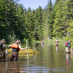
Watch researchers in the Arctic!
Tingmerkpuk Ridges
Jurassic rocks exposed in thurst-faulted structures near the southern limit of Western North Slope. In the subsurface farther north, these rocks may be reservoir rocks for natural gas.

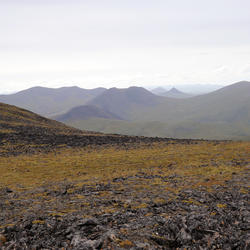
Western North Slope Foothills
The Kukpowruk River cuts through folded Cretaceous rocks in the central North Slope. These rocks were assessed by the USGS in 2017 and lie above the rocks assessed in the USGS 2021 Western North Slope assessment.

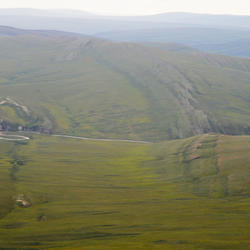
Western North Slope Foothills
Geologist hikes across folded Cretaceous rocks in the central North Slope. These rocks were assessed by the USGS in 2017 and lie above the rocks assessed in the USGS 2021 Western North Slope assessment.

Kukpowruk Redwul
Geologist examines f Faulted and folded petroleum source rocks in Jurassic and Cretaceous rocks (Kingak Shale, pebble shale unit, and gamma-ray zone of Hue Shale) in southern part of Western North Slope. Thermal maturity of these rocks is at the upper limit of oil preservations. Oil odor indicates that oil was generated from these rocks but it likely migrated to other
...
Surprise Creek, Western North Slope of Alaska
Overview of folded Triassic, Jurassic, and Cretaceous rocks in southern part of Western North Slope.

Tingmerkpuk Ridges
Geologists discuss the geology of Jurassic rocks in thurst-faulted structures near the southern limit of Western North Slope.

Kokolik River Oil Sand
Oil-saturated sandstone in the Nanushuk Formation in westernmost National Petroleum Reserve in Alaska (NPR-A). Oil in these rocks likely was generated beneath Western North Slope and migrated northeastward into NPR-A.
Kukpowruk Redwul
Faulted and folded petroleum source rocks in Jurassic and Cretaceous rocks (Kingak Shale, pebble shale unit, and gamma-ray zone of Hue Shale) in southern part of Western North Slope. Thermal maturity of these rocks are at the upper limit of oil preservations. Oil odor indicates that oil was generated from these rocks but it likely migrated to other rocks or was transformed
...
5 meter DEM - Recent Updates (Alaska only)
5 meter DEM - Recent Updates (Alaska only)

5 meter DEM - Availability (Alaska only)
5 meter DEM - Availability (Alaska only)

Ifsar Digital Surface Model - Availability (Alaska only)
Ifsar Digital Surface Model - Availability (Alaska only)
Dragonfly Mercury Project specimen collection in Glacier NP
Researchers instruct volunteers on how to collect dragonfly larvae in Glacier NP as a part of the Dragonfly Mercury Project.
Browse a collection of stories about prominent USGS scientists and projects in Alaska news.
Originally Published by: The Daily News
By: U.S. Geological Survey Director James Reilly
This article has been reprinted or reproduced with the permission of the The Daily News in Longview WA.
A total of $634,000 will fund new research and preserve important data across the Last Frontier.
The scarcity or overabundance of water presents some of the most dangerous, damaging and costly threats to human life, ecosystems and property in the form of drought, floods and debris flows.
")
Disasters and emergencies can happen at any time, often without warning. Natural hazards threaten thousands of lives and cause billions of dollars in damage every year throughout the nation.

USGS Mineral Resources Program Highlights for the Summer 2020 Edition of the USGS Energy Quarterly Newsletter
U.S. Geological Survey field crews are measuring flooding across the country as spring weather is in full swing. Warming temperatures, increased precipitation and snowmelt have caused moderate to major flooding in the upper Midwest, East Coast, Central Plains and the Southeast portions of the country.

Budget Focuses on Bringing Science, Facilities, and Infrastructure into the 21st Century

USGS continues its estimates of technically recoverable oil and gas in Alaska's North Slope.

Access to 3D seismic mapping, along with a greater understanding of gas hydrate reservoir properties, yields estimates that are more precise.

In the far north of Alaska, near the giant Prudhoe Bay oil field, an international research consortium has been studying the potential of an altogether different energy source. In late December of 2018, drilling operations confirmed the existence of two high-quality reservoirs that were fully saturated with a potential alternative fuel source: gas hydrate.

Recent geological studies of a key section of the Aleutian Island chain of Alaska suggest Aleutian tsunamis may occur more frequently than previously understood.

A magnitude 7.0 earthquake struck north of Anchorage, Alaska, on November 30, 2018, at 8:29 a.m. local time (17:29:28 UTC). For the most up-to-date information, please visit the USGS event page, and for estimates of casualties and damage, visit the USGS Prompt Assessment of Global Earthquakes for Response (PAGER) website.
Stay up-to-date with what is happening in the Alaska Region by checking out our different social media accounts. You can also contact Alaska Regional Office staff or Center Directors for more information.
Contacts
Locations


Alaska Science Center
Phone: (907) 786-7000
Fax: (907) 786-7020

Alaska Climate Adaptation Science Center

USGS Volcano Science Center
Phone: 360-993-8900
Alaska Volcano Observatory (AVO)
http://www.avo.alaska.edu/contact.php
Phone: 907-786-7497

USGS Cascades Volcano Observatory (CVO)
vhpweb@usgs.gov
Phone: 360-993-8900
Fax: 360-993-8980
USGS California Volcano Observatory (CalVO package delivery)
askcalvo@usgs.gov
Phone: 650-329-5083

Yellowstone Volcano Observatory (YVO)
yvowebteam@usgs.gov
Phone: 360-993-8906

Anchorage Field Office - Water
Phone: 907-786-7000

Fairbanks Field Office - Water
Phone: 907-479-5645

Juneau Field Office - Water
Phone: 907-586-7216

Social Media
The Regional Office provides active input to a variety of external collaborations by:
-
Serving on science advisory boards (eg. NPRB, AOOS, Alaska Sea Grant, NSSI, WMO);
-
Serving on technical working groups for organizations (eg. AGC, IARPC, CAFF, and Arctic SDI);
-
Providing frequent peer review for decisions by external institutions (eg. IPCC, Fulbright Scholar Program, NFWF, and regional journals).