
Unified Interior Regions
Region 6: Arkansas-Rio Grande-Texas-Gulf
Regions L2 Landing Page Tabs
We conduct impartial, multi- and interdisciplinary research and monitoring to address a broad range of scienctific issues that affect the Arkansas-Rio Grande-Texas-Gulf Region.
News

Media Bulletin: Low-Flying Airplane and Helicopter Mapping Parts of West Texas and South-Central New Mexico to aid in Mapping Geology
Editor: In the public interest and in accordance with FAA regulations, the USGS is announcing this low-level airborne project. Your assistance in informing the local communities is appreciated.

USGS Estimates Undiscovered Oil and Gas Resources in the Austin Chalk Formation of the U.S. Gulf Coast
The Austin Chalk and Tokio and Eutaw Formations of the Gulf Coast Basin contain a mean of 6.9 billion barrels of oil and 41.5 trillion cubic feet of natural gas according to a new assessment by the U.S. Geological Survey. In comparison, the U.S. Energy Information Administration estimates that the United States used 7.5 billion barrels of petroleum products in 2019.

USGS Science to Keep Us Safe: Floods and Drought
The scarcity or overabundance of water presents some of the most dangerous, damaging and costly threats to human life, ecosystems and property in the form of drought, floods and debris flows.
Publications

Potentiometric surfaces, 2011–12, and water-level differences between 1995 and 2011–12, in wells of the “200-foot,” “500-foot,” and “700-foot” sands of the Lake Charles area, southwestern Louisiana
Water levels were determined in 90 wells to prepare 2011–12 potentiometric surfaces focusing primarily on the “200-foot,” 500-foot,” and “700-foot” sands of the Lake Charles area, which are part of the Chicot aquifer system underlying Calcasieu and Cameron Parishes of southwestern Louisiana. These three aquifers provided 34 percent of the total...
White, Vincent E.; Griffith, Jason M.
Geologic framework and hydrostratigraphy of the Edwards and Trinity aquifers within northern Medina County, Texas
The karstic Edwards and Trinity aquifers are classified as major sources of water in south-central Texas by the Texas Water Development Board. During 2018–20 the U.S. Geological Survey, in cooperation with the Edwards Aquifer Authority, mapped and described the geologic framework and hydrostratigraphy of the rocks composing the Edwards and Trinity...
Clark, Allan K.; Morris, Robert E.; Pedraza, Diana E.
Compounds of emerging concern detected in water samples from potable water and wastewater treatment plants and detected in water and bed-sediment samples from sites on the Trinity River, Dallas, Texas, 2009–13
The population in the Dallas-Fort Worth metropolitan area in northern Texas is rapidly growing, resulting in a rapid increase in the demand for potable water and an increase in the discharge of wastewater treatment plant effluent. An assessment of compounds of emerging concern (CECs) in samples collected at potable water and wastewater treatment...
Churchill, Christopher J.; Baldys III, Stanley; Gunn, Cathina L.; Mobley, Craig A.; Quigley, Daniel P.
Urban Waters Federal Partnership - Edwards Aquifer Recharge in a Developing Landscape
San Antonio Texas consistently ranks as one of the fastest growing large cities in the United States. Urban development can affect groundwater quality as trees and open space are replaced by buildings and roads, increasing the amount of urban runoff draining directly into the Edwards aquifer. A network of sophisticated surface water and groundwater monitoring sites is being used to help...

Real-Time Storm Response
Coastal change forecasts and pre- and post-storm photos documenting coastal change for landfalling storms. Currently responding to Hurricane Dorian.

Gulf Coast Ecosystem Restoration Council Monitoring and Assessment Program Development
The National Oceanic and Atmospheric Administration (NOAA) and USGS will jointly lead the development of foundational components for Gulf region-wide monitoring.
Concealed Rare Earth Element (REE) Terranes in the Southern Basin and Range Geologic Province
The project is developing an understanding of the types, sizes, and spatial distribution of rare earth element (REE) related deposits in the southern Basin and Range geologic province to help ensure the availability of rare earth elements to the U.S.
 - Black (TM)")

United States Assessments of Undiscovered Oil and Gas Resources
USGS Energy Resources Program provides periodic assessments of the oil and natural gas endowment of the United States and the World. This website provides access to new, prioritized, assessment results and supporting data for the United States, as part of the Energy Policy and Conservation Act (EPCA).

Identification of Hydrologic Controls on Coastal Spartina patens Marshes and Optimal Hydrological Conditions for Sustainable Mottled Duck Habitat
Mottled ducks rely on the coastal marshes of the Texas Chenier Plain, which are considered among the most critically endangered habitats in the United States. USGS scientists are evaluating what might be contributing to the degradation of high-quality mottled duck habitat to better understand the causes of habitat loss and subsequently mitigate those losses.
")
The Nonindigenous Aquatic Species Alert Risk Mapper (ARM)
The Nonindigenous Aquatic Species (NAS) program has developed a new tool, the NAS Alert Risk Mapper (ARM), to characterize waterbodies in the conterminous U.S. and Hawaii at potential risk of invasion from a new nonindigenous species sighting.
")
Defining Native Ranges of U.S. Inland Fishes
Understanding the native versus non-native range of a species can provide useful information about dispersal, population distribution patterns, and human mediated movement across hydrologic barriers. The USGS Nonindigenous Aquatic Species (NAS) Program is working with partners to define native ranges of inland fishes in the United States to help identify which species should be included in the...

The Nonindigenous Aquatic Species Flood and Storm Tracker (FaST)
Storm-related flooding can lead to the potential spread of nonindigenous (or non-native) aquatic species into waterways they have not been seen in before. The USGS Nonindigenous Aquatic Species program has developed an innovative mapping tool to help natural resource managers with post-storm nonindigenous aquatic species detection and assessment efforts.

Natural Resource Damage and Assessment (NRDA) Program Monitoring and Adaptive Management
State and Federal agencies are working together to assess the damage caused by the Deepwater Horizon oil spill and to determine appropriate restoration actions to restore natural resources, ecological services, and recreational services injured or lost due to the incident.

Texas Water Dashboard
The Texas Water Dashboard presents USGS real-time stream, lake and reservoir, precipitation and groundwater data for more than 850 USGS real-time observation stations in Texas.
Data for assessing the susceptibility of groundwater used for drinking water supply from selected principal aquifers of the Western United States, 2004-2018
Groundwater age distribution and susceptibility to natural and anthropogenic contaminants were assessed for selected principal aquifers of the Western United States: the Central Valley aquifer system (CVAL), the Basin and Range basin-fill aquifers (BNRF), the Rio Grande aquifer system (RIOG), the High Plains aquifer (HPAQ), the Columbia Plateau basaltic-rock aquifers (
Crustal Architecture Beneath the Southern Midcontinent (USA) -- Data Grids and 3D Geophysical Models
Regional grid files and 3D voxel models were used to study crustal architecture beneath the Southern Midcontinent (USA) by McCafferty and others (2019). The study covered a rectangular, multi-state area of 924 by 924 kilometers centered on Missouri, and a corresponding volume extending from the topographic surface to a depth of 50 kilometers below sea level. The grid files consist of
USGS National and Global Oil and Gas Assessment Project - Permian Basin Province, Midland Basin, Wolfcamp Shale Assessment Unit Boundaries and Assessment Input Data Forms, Version 2.0
The Assessment Unit is the fundamental unit used in the National Assessment Project for the assessment of undiscovered oil and gas resources. The Assessment Unit is defined within the context of the higher-level Total Petroleum System. The Assessment Unit is shown herein as a geographic boundary interpreted, defined, and mapped by the geologist responsible for the province and incorporates...

National Water Information System (NWIS) Mapper
The NWIS mapper provides access to over 1.5 million sites contained in the USGS National Water Information System (NWIS), including sites where current and historical surface-water, groundwater, springs, and atmospheric data has been collected. Users can search by site type, data type, site number, or place.

Downloadable Data for Arkoma Basin Oil and Gas Assessments
GIS Data for Arkoma Basin Oil and Gas Assessments
Downloadable Data for Southern Oklahoma Oil and Gas Assessments
GIS Data for Southern Oklahoma Oil and Gas Assessments
Downloadable Data for Nemaha Uplift Oil and Gas Assessments
GIS Data for Nemaha Uplift Oil and Gas Assessments
Downloadable Data for Palo Duro Basin Oil and Gas Assessments
GIS Data for Palo Duro Basin Oil and Gas Assessments
Downloadable Data for Marathon Thrust Belt Oil and Gas Assessments
GIS Data for Marathon Thrust Belt Oil and Gas Assessments
Downloadable Data for Cherokee Platform Oil and Gas Assessments
Downloadable Data for Cherokee Platform Oil and Gas Assessments
Downloadable Data for Anadarko Basin Oil and Gas Assessments
Downloadable Data for Anadarko Basin Oil and Gas Assessments
This map shows the provinces assessed by the USGS for undiscovered oil and gas resources.

Digital map of aquifer boundary for the High Plains aquifer in parts of Colorado, Kansas, Nebraska, New Mexico, Oklahoma, South Dakota, Texas, and Wyoming - This digital data set represents the extent of the High Plains aquifer in the central United States

View topographic and bathymetric contour data and query water depths for the Neosho River, Spring River and Elk River, in northeastern Oklahoma.
Funding partners: Grand River Dam Authority

Information on the latest earthquakes in Oklahoma.

View topographic and bathymetric contour data and simulate Neosho River inundation areas for selected (and real-time) water-surface elevations at Grand Lake and the Neosho River streamgage near Commerce
Funding partners: U.S. Army Corps of Engineers, Grand River Dam Authority, and Oklahoma Department of Wildlife

View topographic and bathymetric contour data and simulate Shawnee (Twin Lakes) Reservoir inundation areas for selected (and real-time) water-surface elevations.
Funding partners: City of Shawnee

June 1 marks the beginning of hurricane season. Should storms arrive on the Louisiana coast, the people in coastal communities across the State, along with many Federal, State, and local agencies will need to know how the storms are affecting the coastal and low-lying areas.The USGS maintains an extensive network of coastal gages that provides critical time-sensitive water level.

The 3DEP products and services available through The National Map consist of standard digital elevation models (DEMs) at various horizontal resolutions, elevation source and associated datasets, an elevation point query service and bulk point query service. All 3DEP products are available, free of charge and without use restrictions.

Grand Lake Data Viewer - View topographic and bathymetric contour data and simulate Grand Lake inundation areas for selected water-surface elevations.
Funding partners: U.S. Army Corps of Engineers, Grand River Dam Authority, and Oklahoma Department of Wildlife Conservation

Drought monitoring for Oklahoma.

Flood Database for Oklahoma - Obtain records of historical flood depth and discharge measurements as well as flood-related news clippings.
Funding partners: Oklahoma Department of Transportation

Delineate custom drainage basins, compute basin characteristics, and estimate streamflow statistics.
Funding partners: Oklahoma Department of Transportation and Oklahoma Water Resources Board
Potentiometric surfaces, 2011–12, and water-level differences between 1995 and 2011–12, in wells of the “200-foot,” “500-foot,” and “700-foot” sands of the Lake Charles area, southwestern Louisiana
Water levels were determined in 90 wells to prepare 2011–12 potentiometric surfaces focusing primarily on the “200-foot,” 500-foot,” and “700-foot” sands of the Lake Charles area, which are part of the Chicot aquifer system underlying Calcasieu and Cameron Parishes of southwestern Louisiana. These three aquifers provided 34 percent of the total...
White, Vincent E.; Griffith, Jason M. Geologic framework and hydrostratigraphy of the Edwards and Trinity aquifers within northern Medina County, Texas
The karstic Edwards and Trinity aquifers are classified as major sources of water in south-central Texas by the Texas Water Development Board. During 2018–20 the U.S. Geological Survey, in cooperation with the Edwards Aquifer Authority, mapped and described the geologic framework and hydrostratigraphy of the rocks composing the Edwards and Trinity...
Clark, Allan K.; Morris, Robert E.; Pedraza, Diana E. Compounds of emerging concern detected in water samples from potable water and wastewater treatment plants and detected in water and bed-sediment samples from sites on the Trinity River, Dallas, Texas, 2009–13
The population in the Dallas-Fort Worth metropolitan area in northern Texas is rapidly growing, resulting in a rapid increase in the demand for potable water and an increase in the discharge of wastewater treatment plant effluent. An assessment of compounds of emerging concern (CECs) in samples collected at potable water and wastewater treatment...
Churchill, Christopher J.; Baldys III, Stanley; Gunn, Cathina L.; Mobley, Craig A.; Quigley, Daniel P.
Effects of urbanization on water quality in the Edwards aquifer, San Antonio and Bexar County, Texas
OverviewContinuous water-quality monitoring data and chemical analysis of surface-water and groundwater samples collected during 2017–19 in the recharge zone of the Edwards aquifer were used to develop a better understanding of the surface-water/groundwater connection in and around Bexar County in south-central Texas. This fact sheet is provided...
Opsahl, Stephen P.; Musgrove, MaryLynn; Mecum, Keith E.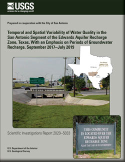
Temporal and spatial variability of water quality in the San Antonio segment of the Edwards aquifer recharge zone, Texas, with an emphasis on periods of groundwater recharge, September 2017–July 2019
Ongoing urbanization on the Edwards aquifer recharge zone in the greater San Antonio area raises concern about the potential adverse effects on the public water supply from development. To address this concern, the U.S. Geological Survey, in cooperation with the City of San Antonio, studied patterns of temporal and spatial changes in water quality...
Opsahl, Stephen P.; Musgrove, MaryLynn; Mecum, Keith E.
Status of groundwater-level altitudes and long-term groundwater-level changes in the Chicot, Evangeline, and Jasper aquifers, Houston-Galveston region, Texas, 2020
Since the early 1900s, most of the groundwater withdrawals in the Houston-Galveston region, Texas, have been from the three primary aquifers that compose the Gulf Coast aquifer system—the Chicot, Evangeline, and Jasper aquifers. Withdrawals from these aquifers are used for municipal supply, commercial and industrial use, and irrigation. This...
Braun, Christopher L.; Ramage, Jason K.
Characterization of peak streamflow and stages at selected streamgages in eastern and northeastern Oklahoma from the May to June 2019 flood event—With an emphasis on flood peaks downstream from dams and on tributaries to the Arkansas River
As much as 22 inches of rain fell in Oklahoma in May 2019, resulting in historic flooding along the Arkansas River and its tributaries in eastern and northeastern Oklahoma. The flooding along the Arkansas River and its tributaries that began in May continued into June 2019. Peaks of record were measured at nine U.S. Geological Survey (USGS) and U....
Lewis, Jason M.; Williams, David J.; Harris, Sarah J.; Trevisan, Adam R.
Geochemical assessment of the Hueco Bolson, New Mexico and Texas, 2016–17
Understanding groundwater quality in transboundary aquifers like the Hueco Bolson is important for the 2.7 million people along the United States and Mexico border living in and near the combined metropolitan areas of Ciudad Juárez, Mexico, and El Paso, Texas, who rely on groundwater for water supply. To better understand water-quality conditions...
Ging, Patricia B.; Humberson, Delbert G.; Ikard, Scott J.
InFRM Flood Decision Support Toolbox user guide
Digital geospatial flood inundation mapping can be a powerful tool for flood risk management. Flood preparedness, communication, warning, response and mitigation can be enhanced by flood inundation mapping that shows floodwater extent and depth over the land surface. Flood inundation maps that accurately reflect observed and forecasted...

Effects of huisache removal on rangeland evapotranspiration in Victoria County, south-central Texas, 2015–18
The U.S. Geological Survey and Desert Research Institute, in cooperation with the Natural Resources Conservation Service, Texas State Soil and Water Conservation Board, Victoria County Groundwater Conservation District, Victoria Soil and Water Conservation District, and the San Antonio River Authority, evaluated the hydrologic effects of Vachellia...
Slattery, Richard N.; Ockerman, Darwin J.; Bromley, Matthew; Huntington, Justin; Banta, John R.
Hydrogeologic units, contour maps, and cross sections of the Boone and Roubidoux aquifers, northeastern Oklahoma, 2020
The Boone and Roubidoux aquifers (or their equivalents) are the main sources of fresh groundwater in northeastern Oklahoma. Projected total water demand of both surface water and groundwater in northeastern Oklahoma is expected to increase approximately 56 percent from 2010 to 2060. This report provides an overview of the hydrogeology of...
Russell, Cory A.; Stivers, Jacob W. Landfill leachate contributes per-/poly-fluoroalkyl substances (PFAS) and pharmaceuticals to municipal wastewater
Widespread disposal of landfill leachate to municipal sewer infrastructure in the United States calls for an improved understanding of the relative organic-chemical contributions to the wastewater treatment plant (WWTP) waste stream and associated surface-water discharge to receptors in the environment. Landfill leachate, WWTP influent, and WWTP...
Masoner, Jason R.; Kolpin, Dana W.; Cozzarelli, Isabelle M.; Smalling, Kelly L.; Bolyard, Stephanie; Field, Jennifer; Furlong, Edward T.; Gray, James L.; Lozinski, Duncan; Reinhart, Debra; Rodowa, Alix; Bradley, Paul M.
Flight area for Trans-Pecos aeromagnetic and radiometric survey
Map indicating flight area for Trans-Pecos aeromagnetic and radiometric survey. The survey area includes parts of El Paso and Hudspeth counties, Texas, and Otero County, New Mexico. Flights will begin in November 2020 and are expected to conclude in mid-January 2021.
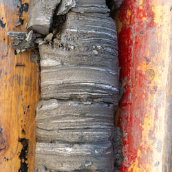
Austin Chalk Core
Bedding features in the core from the USGS Gulf Coast #4 Bonham borehole, in the Eagle Ford Group mudstones from a depth of about 401 feet, Fannin County, Texas. The Eagle Ford Group lies underneath the Austin Chalk and serves as the source rock for much of the Austin Chalk's petroleum.
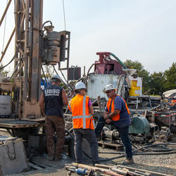
USGS Technicians Prepare to Take a Core of the Austin Chalk in Texas
USGS technicians at the USGS Gulf Coast #4 Bonham borehole in preparation for geophysical logging of the Austin Chalk Group and the Eagle Ford Group mudstones, Fannin County, Texas.

Dragonfly Mercury Project specimen collection in Glacier NP
Researchers instruct volunteers on how to collect dragonfly larvae in Glacier NP as a part of the Dragonfly Mercury Project.

Oil, gas, and water separation vessels
Oil, gas, and water separation vessels at a carbon dioxide enhanced oil recovery operation, Horseshoe Atoll, Upper Pennsylvanian Wolfcampian play in the Permian Basin Province in Texas.

Surveying Contracted-Opening Indirect Measurements
This video goes into detail about surveying high-water marks, various aspects of bridges, and cross sections for the contracted-opening method.

Requirements for the Contracted-Opening Method
This video discusses the general requirements that will be needed to accomplish a contracted-opening indirect discharge measurement. Approach section, contracted section, and necessary high-water mark locations are described along with scenarios where the method will not be successful.

Climate Projections as a Way to Illustrate Future Possibilities
This video is a recording of the webinar “Climate Projections as a Way to Illustrate Future Possibilities" that is part of the USGS National Climate Adaptation Science Center (NCASC), in partnership with the National Conservation Training Center (NCTC), 2019 webinar series. Previous recordings can be found at https

Image of the Week - Lake Meredith’s Return
Lake Meredith National Recreation Area takes its name from the water body it surrounds in the Texas Panhandle. The Amarillo-area lake sees more than a million visitors a year.
Visitor numbers were much smaller just a few years ago. More than a decade of drought shrank water levels at Lake Meredith until a rush of rain in 2017 brought a turnaround.
Each week,
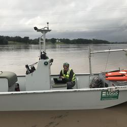
Collecting flood data on the Llano River in response to a flash flood
USGS scientist Scott Grzyb reviews high-water data collected by boat on the Llano River in Llano, Texas in response to a flash flood on October 8, 2018.

End of a long day collecting flood data on the Llano River
USGS scientists Scrott Grzyb and Michael Scheider pause at sunset at the end of a long day collecting high-water measurements along the Llano River on October 8, 2018.

Habitat Connectivity: Assessing Threats and IDing Conservation Actions
An important conservation strategy for climate change is to enhance and maintain regional habitat connectivity for the long-term viability of wildlife populations. Modeling habitat connectivity for wildlife species often results in a mapped network of linkages between habitat patches. A critical next step is to determine which of those linkages are priorities for
Editor: In the public interest and in accordance with FAA regulations, the USGS is announcing this low-level airborne project. Your assistance in informing the local communities is appreciated.
The Austin Chalk and Tokio and Eutaw Formations of the Gulf Coast Basin contain a mean of 6.9 billion barrels of oil and 41.5 trillion cubic feet of natural gas according to a new assessment by the U.S. Geological Survey. In comparison, the U.S. Energy Information Administration estimates that the United States used 7.5 billion barrels of petroleum products in 2019.
The scarcity or overabundance of water presents some of the most dangerous, damaging and costly threats to human life, ecosystems and property in the form of drought, floods and debris flows.

As Hurricane Laura came ashore near the Texas and Louisiana borders, its strong winds pushed so much water ahead of it that the Neches River even flowed backwards for a time, according to a USGS streamgage in Beaumont.

To learn more about USGS’s role in providing science to decision makers before, during and after Hurricane Laura, visit www.usgs.gov/laura
U.S. Geological Survey field crews are measuring flooding across the country as spring weather is in full swing. Warming temperatures, increased precipitation and snowmelt have caused moderate to major flooding in the upper Midwest, East Coast, Central Plains and the Southeast portions of the country.

On March 26, 2020, a magnitude 5.0 earthquake struck West Texas near the New Mexico border. Seismic instruments indicate the earthquake originated at a depth of 5.3 miles (8.5 kilometers).

Budget Focuses on Bringing Science, Facilities, and Infrastructure into the 21st Century

New tools for flood preparedness are now available for the Medina River near Bandera, Texas, from the U.S. Geological Survey, the Bandera County River Authority and Groundwater District, and the Texas Water Development Board.

NOAA's annual prediction based on USGS data

Reporters: Do you want to Accompany USGS Scientists as they Measure Record Flooding in Oklahoma? Please Contact Heidi Koontz or Jason Lewis.

An interactive viewer to visualize groundwater resources in Gaines, Terry and Yoakum Counties, Texas, is now available from the U.S. Geological Survey in cooperation with the Llano Estacado Underground Water Conservation District, Sandy Land Underground Water Conservation District and South Plains Underground Water Conservation District.
Contacts
Locations

Region 6: Arkansas-Rio Grande-Texas-Gulf

South Central Climate Adaptation Science Center

Texas Water Science Center
Phone: (512) 927-3500
Fax: (512) 927-3590

Oklahoma Water Science Center
Phone: 405-810-4400
Fax: 405-843-7712

Woodward Field Office
Phone: 580-256-5031

Tulsa Field Office
Phone: 918-254-6651

Lubbock Field Office
Phone: (806) 742-3129
Fax: (806) 742-0100

Gulf Coast Branch (Houston) Office
Phone: (936) 271-5300
Fax: (936) 271-5399

Wichita Falls Field Office
Phone: (940) 397-4453

North Texas Branch (Fort Worth) Office
Phone: (817) 263-9545
Fax: (682) 316-5022

El Paso Field Office
Phone: (915) 534-6308
Fax: (915) 534-6299

San Angelo Field Office
Phone: (325) 944-4600
Fax: (325) 942-0495

Corpus Christi Field Office
Phone: (361) 825-2073
Fax: (361) 825-2025

South Texas Branch (San Antonio) Office
Phone: (210) 691-9200
Fax: (210) 691-9270