Geospatial Services
Information Resources and Technology Management
*** If you are having trouble viewing this page please click here
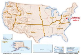
GIS Image


FWS Service Catalog (ServCat) Public Access


Coastal Barrier Resources System (CBRS)
The Coastal Barrier Resources Act (CBRA) of 1982 established the John H. Chafee Coastal Barrier Resources System (CBRS), comprised of undeveloped coastal barriers along the Atlantic, Gulf, and Great Lakes coasts.
a

Download Digital CBRS Boundaries Data
Link Official CBRS Maps
a
 

Critical Habitat
The Critical Habitat portal is an online service for information regarding Threatened and Endangered Species final Critical Habitat designation across the United States. Not all of the critical habitat data designated by the U.S. Fish & Wildlife Service (USFWS) is available from this portal.
a

Download Critical Habitat Data
a
 

USFWS Ecosystem Regions
Digital ecosystem information portraying the location and boundaries of the ecosystems. The Service originally chose the USGS Hydrologic Unit Map as the foundation for ecosystem unit boundaries, some of the region boundaries have been moved to the closest county boundary. The current unit boundaries reflect this combination.
a

Download USFWS Ecosystem Regions
 

Landscape Conservation Cooperatives (LCCs)
Landscape Conservation Cooperatives (LCCs) are public-private partnerships composed of states, tribes, federal agencies, non-governmental organizations, universities, international jurisdictions, and others working together to address landscape and seascape scale conservation issues. LCCs inform resource management decisions to address broad-scale stressors-including habitat fragmentation, genetic isolation, spread of invasive species, and water scarcity-all of which are magnified by a rapidly changing climate. For further information go to http://lccnetwork.org.
a

Mapper LCC Network Areas Data
a


Migratory Bird Conservation
In order to make important agency databases available through the Bird Conservation Node, the USFWS and USGS formed the Migratory Bird Data Center. Building upon complementary capabilities of the USFWS and the USGS, the objectives of this Center are to: (1) assemble and document bird population and habitat data maintained by these agencies at their finest levels of spatial and temporal resolution; (2) assure that databases remain current through periodic update; and (3) provide web-based access to the data by researchers and managers for strategic planning and evaluation of avian conservation strategies.
a

Download Migratory Birds Data
Link Migratory Bird Data Center
a
 

North American Bird Conservation Joint Ventures
A joint venture is a self-directed partnership of agencies, organizations, corporations, tribes, or individuals that has formally accepted the responsibility of implementing national or international bird conservation plans within a specific geographic area or for a specific taxonomic group, and has received general acceptance in the bird conservation community for such responsibility. Under the guidance of national and international bird conservation plans, Joint Ventures increase the efficiency and effectiveness of habitat conservation efforts by bringing together leading wildlife organizations, agencies, and scientists to jointly develop, update, and implement these strategies.
a

Download North American Bird Conservation Joint Ventures
Mapper North American Bird Conservation Joint Ventures Map Service
a
 
North American Migratory Bird Conservation Joint Ventures Map

^ Return to Top of Page ^

National Wetlands Inventory (NWI)
NWI has developed a series of topical maps to show wetlands and deepwater habitats. This geospatial information is used by Federal, State, and local agencies, academic institutions, and private industry for management, research, policy development, education and planning activities. Digital data can be viewed and downloads are available through the Wetlands Mapper.
a

Link National Wetlands Inventory (NWI) Data and Metadata
Mapper National Wetlands Inventory Map Services
a
 
NWI Mapper Image

^ Return to Top of Page ^

National Wildlife Refuge System (NWRS)
Boundary Data
These datasets depict the USFWS approved acquisition boundaries and USFWS managed lands, (National Wildlife Refuge and Hatchery Boundaries). The intended application of these data layers is as a cadastral framework for use with other data layers in GIS and mapping applications. It is not intended to be used as a land survey or representation of land for conveyance or tax purposes.
a

Link USFWS National Cadastral Data
a
 
Pelican Island NWR Boundary Image

^ Return to Top of Page ^

National Wildlife Refuge System (NWRS) General Information
Baseline inventory of public assets owned and maintained by the USFWS.
a

Download Primary Visitor Services and Campgrounds
Download Refuge Roads, Trails and Parking Lots
Mapper Refuge Trails Map Service
Download National Wildlife Refuge System Fishing and Hunting Opportunies
a
 
Pelican Island Trail Image

Central Federal Lands Road Pelican Island Road Image

^ Return to Top of Page ^

Corporate Master Table (CMT) Locations
This data consists of point locations of USFWS stations taken from the Corporate Master Table.
a

Download USFWS CMT Location Data
a
 
USFWS CMT Locations Image

^ Return to Top of Page ^

Regional Boundaries
USFWS Regional Boundaries.
a

Download USFWS Regional Boundaries
a
 
USFWS Regions Image

^ Return to Top of Page ^