
Unified Interior Regions
Region 11: Alaska
Alaska Science Center

4210 University Drive
Anchorage, AK 99508
Phone: (907) 786-7000
Volcano Science Center

4230 University Drive
Anchorage, AK 99508
Phone: (907) 786-7497
Climate Adaptation Science Center

4230 University Drive
Anchorage, AK 99508
Phone: 907-301-7830
Regions L2 Landing Page Tabs
USGS in Alaska conducts science for decision-making in five major areas: natural hazards; energy & minerals; water quality, streamflow & ice; wildlife, fish & habitat; and geospatial mapping. The Alaska Regional Office provides management and strategic coordination among the Alaska Science Center, the Volcano Science Center, the Climate Adaptation Science Center, & other partners operating in AK.
View Centers and ObservatoriesNews

ICYMI Bulletin: Community Voices: New Volcano Monitors Increase Safety
Originally Published by: The Daily News
By: U.S. Geological Survey Director James Reilly
This article has been reprinted or reproduced with the permission of the The Daily News in Longview WA.

Earth MRI Funds Critical Minerals Projects in Alaska
A total of $634,000 will fund new research and preserve important data across the Last Frontier.

USGS Science to Keep Us Safe: Floods and Drought
The scarcity or overabundance of water presents some of the most dangerous, damaging and costly threats to human life, ecosystems and property in the form of drought, floods and debris flows.
Publications

Polar Bear (Ursus maritimus)
This chapter comprises the following sections: names, taxonomy, subspecies and distribution, descriptive notes, habitat, movements and home range, activity patterns, feeding ecology, reproduction and growth, behavior, parasites and diseases, status in the wild, and status in captivity.
Rode, Karyn D.; Obbard, Martyn E.; Belikov, Stanislav; Derocher, Andrew E.; Durner, George M.; Thiemann, Gregory; Tryland, Morten; Letcher, Robert J.; Meyersen, Randi; Sonne, Christian; Jenssen, Bjorn; Dietz, Rune; Vongraven, Dag How Is climate change affecting polar bears and giant pandas?
Anthropogenic greenhouse gas emissions are the primary cause of climate change and an estimated increase of 3.7 to 4.8 °C is predicted by the year 2100 if emissions continue at current levels. Polar bears (Ursus maritimus) and giant pandas (Ailuropoda melanoleuca) provide an interesting comparison study of the impact of climate change on bear...
Songer, Melissa; Atwood, Todd C.; Douglas, David C.; Huang, Qiongyu; Li, Renqiang; Pilfold, Nicholas; Xu, Ming; Durner, George M. Shorebird reproductive response to exceptionally early and late springs varies across sites in Arctic Alaska
While increases in overall temperatures are widely reported in the Arctic, large inter-annual variation in spring weather, with extreme early and late conditions, is also occurring. Using data collected from three sites in Arctic Alaska, we explored how shorebird breeding density, nest initiation, nest synchrony, nest survival, and phenological...
McGuire, Rebecca L; Lanctot, Richard B.; Saalfeld, Sarah T.; Ruthrauff, Daniel R.; Liebezeit, JoeUSGS in Alaska engages approximately 400 scientists and support staff working across 3 major centers with a combined annual science budget of about $65 million. In just the last 5 years, USGS in Alaska has produced scientific benefits resulting from over 1000 publications and about 250 Technical Reports.

Alaska North Slope LiDAR
High-resolution light detection and ranging (lidar) elevation data were acquired along the north coast of Alaska between 2009 and 2012. The lidar acquisition, from Icy Cape, Alaska to the United States/Canadian border, comprised approximately 11,000 km2. The airborne lidar data were acquired in support of the U.S. Geological Survey...

Climate impacts to Arctic coasts
The Arctic region is warming faster than anywhere else in the nation. Understanding the rates and causes of coastal change in Alaska is needed to identify and mitigate hazards that might affect people and animals that call Alaska home.

U.S. West Coast and Alaska Marine Geohazards
Marine geohazards are sudden and extreme events beneath the ocean that threaten coastal populations. Such underwater hazards include earthquakes, volcanic eruptions, landslides, and tsunamis.
Devastating earthquakes in Japan (2011) and Chile (2010) that spawned pan-oceanic tsunamis sent a sobering reminder that U.S. coastlines are also vulnerable to natural disasters that originate in...

Coastal Change Hazards
Natural processes such as waves, tides, and weather, continually change coastal landscapes. The integrity of coastal homes, businesses, and infrastructure can be threatened by hazards associated with event-driven changes, such as extreme storms and their impacts on beach and dune erosion, or longer-term, cumulative...

PCMSC Marine Facility (MarFac)
Learn about the USGS Pacific Coastal and Marine Science Center Marine Facility, or MarFac

Earthquake Hazards in Southeastern Alaska
Over the last 100 years, the Queen Charlotte-Fairweather fault system has produced large-magnitude earthquakes affecting both Canada and the U.S. To fill in missing details about its offshore location and structure, USGS uses sophisticated techniques to truly understand the fault’s hazard potential.

Tracking Data for Yellow-billed Loons (Gavia adamsii)
Available here are tracking data of Yellow-billed loons, a species that breeds in coastal areas of western and northern Alaska and adjacent regions of Russia and Canada. This species winters along the Pacific coasts of North America and Eurasia. These data were collected to better understand the patterns of migratory movements and seasonal use of different regions of Alaska

Assessment of Gas Hydrate Resources in the North Slope of Alaska, 2018
The U.S. Geological Survey (USGS) has updated the previous 2008 assessment of undiscovered, technically recoverable gas hydrate resources beneath the North Slope of Alaska. This new 2018 assessment again indicates the existence of technically recoverable gas hydrate resources―that is, resources that can be discovered, developed, and produced using current technology. Using a geology-based...

Alaska North Slope 2018 Hydrate 01 Stratigraphic Test Well
The National Energy Technology Laboratory (NETL), the Japan Oil, Gas and Metals National Corporation (JOGMEC), and the U.S. Geological Survey (USGS) are leading an effort to conduct an extended gas hydrate production test in northern Alaska.

M7.1 November 30, 2018 Anchorage Earthquake
A magnitude 7.1 earthquake struck north of Anchorage, Alaska, on November 30, 2018, at 8:29 a.m. local time (17:29:28 UTC).

Swan Research
USGS research on swans in Alaska has focused on pathogens, contaminants, and demographic rates in each of the different breeding areas of Alaska. The vastly different migration patterns of swans in Alaska means that there are multiple factors on the wintering grounds and during migration that may influence population size and trends.

Sitka, AK
On August 18, 2015, heavy rainfall triggered around 60 landslides in and around the city of Sitka, AK. The landslides moved downslope rapidly; several were damaging and one of these demolished a home on South Kramer Avenue killing three people.
USGS produces objective, high-quality data that is relevant to decision-makers, resource managers, the scientific community, and the public. Access digital datasets, climate data & analysis tools, interactive maps for volcanic activity, and more!
AK Minerals Resource Data File
Climate Data and Analysis Tools
Search USGS Science Data Catalog
Alaska IfSAR Elevation Data
Radar data is being collected statewide for Alaska under direction of the USGS 3D Elevation Program (3DEP). The new data is vastly improving the accuracy and resolution of elevation data for the state, and is being collected using an airborne Interferometric Synthetic Aperture Radar (IfSAR) sensor. USGS and the State of Alaska maintain web-based status maps and download services.

Elevation Data
The 3DEP products and services available through The National Map consist of lidar point clouds (LPC), standard digital elevation models (DEMs) at various horizontal resolutions, elevation source and associated datasets, an elevation point query service and bulk point query service. All 3DEP products are available, free of charge and without use restrictions.

Volcano Monitoring Data
Many volcanoes in the U.S. are monitored by arrays of several instruments that detect subtle movements within the earth and changes in gas and water chemistry. The Volcano Hazards Program streams this data to its Volcano Observatories and makes it available on volcano-specific websites.

Alaska Volcano Observatory Satellite Data
This is a new tool for understanding and communicating risks. The activities include the development of risk models and approaches to improve the situational awareness of communities and industries to natural hazards and reduce the uncertainty of those risk assessments.

Alaska Volcano Observatory - Is Ash Falling?
Reports of ash fall are important to us; we use your observations to assess the character and size of an eruption plume. We report these data to the National Weather Service so they can keep their Ashfall Advisories current. Additionally, reports of NO ashfall during an eruption with expected ashfall are also important to us.
The USGS is a world leader in producing and distributing maps and geospatial data, ranging from local to national and global scales. The Alaska Mapping Initiative supports the procurement of new topographic maps and data for the Alaska Region to levels commonly found in the rest of the contiguous United States. You can download Alaska US Topo maps for free here.
Alaska Geologic Map
This map shows the provinces assessed by the USGS for undiscovered oil and gas resources.

This is an interactive version of the Alaska geologic map database which allows a user to view and access many features of the database and map through a standard web browser. In other words, there is no need for or knowledge of specialized GIS software.
The 3DEP products and services available through The National Map consist of standard digital elevation models (DEMs) at various horizontal resolutions, elevation source and associated datasets, an elevation point query service and bulk point query service. All 3DEP products are available, free of charge and without use restrictions.

Links to publications that contain maps of the sea floor or lake beds and the digital data used to create them.

New US Topo maps for Alaska are being produced statewide, with digital 7.5 minute 1:25,000-scale maps providing a comprehensive update to the 15-minute 1:63,360-scale printed maps produced nearly fifty years ago. You can view a status map showing where the new maps are available, and link to a site to download the maps.

On March 27, 1964 the largest recorded earthquake in U.S. history struck southcentral Alaska. Click on the photos or the numbers to take a tour.
USGS research activities relevant to Alaska have yielded more than 9400 historical publications. This page features some of the most recent newsworthy research findings.
Search USGS publications for Alaska
Arctic Science for Decision Maker
2019 USGS Alaska Annual Science Report Polar Bear (Ursus maritimus)
This chapter comprises the following sections: names, taxonomy, subspecies and distribution, descriptive notes, habitat, movements and home range, activity patterns, feeding ecology, reproduction and growth, behavior, parasites and diseases, status in the wild, and status in captivity.
Rode, Karyn D.; Obbard, Martyn E.; Belikov, Stanislav; Derocher, Andrew E.; Durner, George M.; Thiemann, Gregory; Tryland, Morten; Letcher, Robert J.; Meyersen, Randi; Sonne, Christian; Jenssen, Bjorn; Dietz, Rune; Vongraven, Dag How Is climate change affecting polar bears and giant pandas?
Anthropogenic greenhouse gas emissions are the primary cause of climate change and an estimated increase of 3.7 to 4.8 °C is predicted by the year 2100 if emissions continue at current levels. Polar bears (Ursus maritimus) and giant pandas (Ailuropoda melanoleuca) provide an interesting comparison study of the impact of climate change on bear...
Songer, Melissa; Atwood, Todd C.; Douglas, David C.; Huang, Qiongyu; Li, Renqiang; Pilfold, Nicholas; Xu, Ming; Durner, George M. Shorebird reproductive response to exceptionally early and late springs varies across sites in Arctic Alaska
While increases in overall temperatures are widely reported in the Arctic, large inter-annual variation in spring weather, with extreme early and late conditions, is also occurring. Using data collected from three sites in Arctic Alaska, we explored how shorebird breeding density, nest initiation, nest synchrony, nest survival, and phenological...
McGuire, Rebecca L; Lanctot, Richard B.; Saalfeld, Sarah T.; Ruthrauff, Daniel R.; Liebezeit, Joe
Bedrock geologic map of the 15' Sleetmute A-2 quadrangle, southwestern Alaska
Twelve unnamed, bedrock stratigraphic units are recognized within the Sleetmute A-2 1:63,360-scale quadrangle of southwestern Alaska. These units range in age from late(?) Proterozoic through Devonian and can be divided into two distinct facies belts: (1) a southern facies of dominantly shallow-water platform carbonate and minor siliciclastic...
Blodgett, Robert; Wilson, Frederic H.; Shew, Nora B.; Clough, James G.
Shorebird research at the U.S. Geological Survey Alaska Science Center
Shorebirds—which include sandpipers, plovers, and oystercatchers—are perhaps best known by their presence on sandy beaches, running along the water’s edge while they probe for food. But they are probably less recognized for their impressive long-distance migrations. Millions of individuals travel from across the globe to breed throughout Alaska...
Ruthrauff, Dan; Tibbitts, Lee; Pearce, John Detection and assessment of a large and potentially‐tsunamigenic periglacial landslide in Barry Arm, Alaska
The retreat of glaciers in response to global warming has the potential to trigger landslides in glaciated regions around the globe. Landslides that enter fjords or lakes can cause tsunamis, which endanger people and infrastructure far from the landslide itself. Here we document the ongoing movement of an unstable slope (total volume of 455...
Dai, Chunli; Higman, Bretwood; Lynett, Patrick J.; Jacquemart, Mylène; Howat, Ian; Liljedahl, Anna K.; Dufresne, Anja; Freymueller, Jeffery T.; Geertsema, Marten; Jones, Melissa Ward; Haeussler, Peter Seabird‐induced natural mortality of forage fish varies with fish abundance: Evidence from five ecosystems
Forage fish populations often undergo large and rapid fluctuations in abundance. However, most of their predators are buffered against such fluctuations owing to their slower pace of life, which allows them to maintain more stable populations, at least during short periods of food scarcity. In this study, we investigated top‐down processes exerted...
Saraux, Claire; Sydeman, William J.; Piatt, John F.; Anker-Nilssen, Tycho; Hentati-Sundberg, Jonas; Bertrand, Sophie; Cury, Philippe M.; Furness, Robert W.; Miller, James A.; Österblom, Henrik; Passuni, Giannina; Roux, Jean-Paul; Shannon, Lynne; Crawford, Robert J.M. Interaction between watershed features and climate forcing affects habitat profitability for juvenile salmon
Opportunities for growth and survival of aquatic organisms are spatially and temporally variable as habitat conditions across watersheds respond to interacting climatic, geomorphic, and hydrologic conditions. As conservation efforts often focus on identifying and protecting critical habitats, it is important to understand how this spatial and...
Walsworth, Timothy E.; Baldock, Jeffrey R; Zimmerman, Christian E.; Schindler, Daniel E. QCam: sUAS-based doppler rdar for measuring river discharge
The U.S. Geological Survey is actively investigating remote sensing of surface velocity and river discharge (discharge) from satellite-, high altitude-, small, unmanned aircraft systems- (sUAS or drone), and permanent (fixed) deployments. This initiative is important in ungaged basins and river reaches that lack the infrastructure to deploy...
Fulton, John W.; Anderson, Isaac E.; Chiu, C.-L.; Sommer, Wolfram; Adams, Josip; Moramarco, Tommaso; Bjerklie, David M.; Fulford, Janice M.; Sloan, Jeff L.; Best, Heather; Conaway, Jeffrey S.; Kang, Michelle J.; Kohn, Michael S.; Nicotra, Matthew J.; Pulli, Jeremy J. Drivers of wildfire carbon emissions
Increasing fire frequency and severity may shift boreal forests from carbon sinks to carbon sources and amplify climate warming. Analysis indicates that that fuel characteristics are important drivers of wildfire carbon emissions across a broad range of North America’s boreal forest.
Loehman, Rachel A. Imaging the tectonic grain of the Northern Cordillera orogen using Transportable Array receiver functions
Azimuthal variations in receiver function conversions can image lithospheric structural contrasts and anisotropic fabrics that together compose tectonic grain. We apply this method to data from EarthScope Transportable Array in Alaska and additional stations across the northern Cordillera. The best‐resolved quantities are the strike and depth of...
Schulte-Pelkum, Vera; Caine, Jonathan; Jones, James V.; Becker, Thorsten W Four decades of land-cover change on the Kenai Peninsula, Alaska: Detecting disturbance-influenced vegetation shifts using landsat legacy data
Across Alaska’s Kenai Peninsula, disturbance events have removed large areas of forest over the last half century. Simultaneously, succession and landscape evolution have facilitated forest regrowth and expansion. Detecting forest loss within known pulse disturbance events is often straightforward given that reduction in tree cover is a readily...
Baughman, Carson; Loehman, Rachel A.; Magness, Dawn R.; Saperstein, Lisa; Sherriff, Rosemary L.
This R script will run one example of the stochastic matrix models run by Weiser et al. (2020) to simulate shorebird populations. The model predicts population growth rates and elasticity values of vital rates. The example script is stand-alone and contains input values for one example species; input values for the other species are provided in the manuscript.

Bioinformatics software repository containing python scripts intended for search and download of genetic information obtained from GenBank NCBI genetics data resources in support of developing PCR primers, targeted genetic databases, genetic analyses, and data interpretation. Includes multiple functions to streamline this process.

Daily sea ice imagery and charting benefits logistics and navigational planning in the Alaskan Arctic waters, yet access to these data often requires high bandwidth data access and substantial GIS processing.
")
Cormack-Jolly-Seber (CJS) mark-recapture models are widely utilized in ecology, providing estimates of vital rates and abundance that are difficult to obtain using other means.

Quantitative fatty acid signature analysis (QFASA; Iverson et al. 2004) has become a common method of estimating diet composition, especially for marine mammals, but the performance of the method has received limited investigation.

The Pedestrian Evacuation Analyst is an ArcGIS extension that estimates how long it would take for someone to travel on foot out of a hazardous area that was threatened by a sudden event such as a tsunami, flash flood, or volcanic lahar. It takes into account the elevation changes and the different types of landcover that a person would encounter along the way.

Quantitative fatty acid signature analysis (QFASA) is a method of diet estimation introduced over a decade ago (Iverson et al. 2004).
Browse a selection of videos, audio clips, images, and more from a wide range of science topics covered by USGS!
"Science for a Changing World" - watch the short film here!
Documentary on walruses here!
Watch the first-ever footage of a polar bear on Arctic sea ice!
Join USGS geologists as they collect lava samples from Kilauea Volcano.
Watch researchers in the Arctic!

5 meter DEM - Recent Updates (Alaska only)
5 meter DEM - Recent Updates (Alaska only)
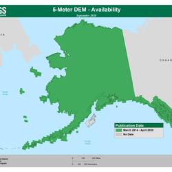
5 meter DEM - Availability (Alaska only)
5 meter DEM - Availability (Alaska only)

Ifsar Digital Surface Model - Availability (Alaska only)
Ifsar Digital Surface Model - Availability (Alaska only)

Geologist at Yukon Tanana Uplands Alaska
Geologist at Yukon Tanana Uplands Alaska. This is part of the Earth MRI project.


Keychain in Inupiaq for USGS outreach activities about bird banding
Keychain developed for USGS outreach activities about bird banding and reporting in Inupiaq and English. Inupiaq translation provided by Qaiyaan and Jana Harcharek.

Tundra swan on the Colville River Delta, Alaska
Tundra swan on the Colville River Delta, Alaska 2013.

Animation depicting seasonal cycles on Alaska's Arctic bluffs
In the spring, winter sea ice thaws and moves offshore leaving the coast exposed to increased wave action and relatively warm water temperatures that, when in contact with the bluff, erodes the toe of the bluff. Additionally, warm air temperatures during the spring and summer months thaw the upper layers of permafrost causing erosion or sloughing of the bluff face above

Climate Adaptation Planning with Alaska-Based Adaptation Tools
The dynamic landscape and climate of Alaska presents many challenges to the over 200 communities that live in rural areas of the state and have a wide variety of resource needs. Coastal and riverine erosion, flooding, wildfire, permafrost dynamics and increasing temperatures act as drivers for many of these landscape changes. Both the Alaska Climate Adaptation Science

Beaver dam and lodge on the Wrench Creek, Noatak National Preserve
Beaver dam and lodge on the Wrench Creek, Noatak National Preserve

Beaver dam complex and lodge at the confluence
Beaver dam complex and lodge at the confluence of Wrench Creek and Kelly River, Noatak National Preserve

Adult Pacific salmon caught in impounded water above beaver dam
Adult Pacific salmon (Oncorhynchus nerka) caught in impounded water above beaver dam. >25 rKM (river KM) from coast.
Browse a collection of stories about prominent USGS scientists and projects in Alaska news.
Originally Published by: The Daily News
By: U.S. Geological Survey Director James Reilly
This article has been reprinted or reproduced with the permission of the The Daily News in Longview WA.
A total of $634,000 will fund new research and preserve important data across the Last Frontier.
The scarcity or overabundance of water presents some of the most dangerous, damaging and costly threats to human life, ecosystems and property in the form of drought, floods and debris flows.
")
Disasters and emergencies can happen at any time, often without warning. Natural hazards threaten thousands of lives and cause billions of dollars in damage every year throughout the nation.

USGS Mineral Resources Program Highlights for the Summer 2020 Edition of the USGS Energy Quarterly Newsletter
U.S. Geological Survey field crews are measuring flooding across the country as spring weather is in full swing. Warming temperatures, increased precipitation and snowmelt have caused moderate to major flooding in the upper Midwest, East Coast, Central Plains and the Southeast portions of the country.

Budget Focuses on Bringing Science, Facilities, and Infrastructure into the 21st Century

USGS continues its estimates of technically recoverable oil and gas in Alaska's North Slope.

Access to 3D seismic mapping, along with a greater understanding of gas hydrate reservoir properties, yields estimates that are more precise.

In the far north of Alaska, near the giant Prudhoe Bay oil field, an international research consortium has been studying the potential of an altogether different energy source. In late December of 2018, drilling operations confirmed the existence of two high-quality reservoirs that were fully saturated with a potential alternative fuel source: gas hydrate.

Recent geological studies of a key section of the Aleutian Island chain of Alaska suggest Aleutian tsunamis may occur more frequently than previously understood.

A magnitude 7.0 earthquake struck north of Anchorage, Alaska, on November 30, 2018, at 8:29 a.m. local time (17:29:28 UTC). For the most up-to-date information, please visit the USGS event page, and for estimates of casualties and damage, visit the USGS Prompt Assessment of Global Earthquakes for Response (PAGER) website.
Stay up-to-date with what is happening in the Alaska Region by checking out our different social media accounts. You can also contact Alaska Regional Office staff or Center Directors for more information.
Contacts
Locations


Alaska Science Center
Phone: (907) 786-7000
Fax: (907) 786-7020

Alaska Climate Adaptation Science Center

USGS Volcano Science Center
Phone: 360-993-8900
Alaska Volcano Observatory (AVO)
http://www.avo.alaska.edu/contact.php
Phone: 907-786-7497

USGS Cascades Volcano Observatory (CVO)
vhpweb@usgs.gov
Phone: 360-993-8900
Fax: 360-993-8980
USGS California Volcano Observatory (CalVO package delivery)
askcalvo@usgs.gov
Phone: 650-329-5083

Yellowstone Volcano Observatory (YVO)
yvowebteam@usgs.gov
Phone: 360-993-8906

Anchorage Field Office - Water
Phone: 907-786-7000

Fairbanks Field Office - Water
Phone: 907-479-5645

Juneau Field Office - Water
Phone: 907-586-7216

Social Media
The Regional Office provides active input to a variety of external collaborations by:
-
Serving on science advisory boards (eg. NPRB, AOOS, Alaska Sea Grant, NSSI, WMO);
-
Serving on technical working groups for organizations (eg. AGC, IARPC, CAFF, and Arctic SDI);
-
Providing frequent peer review for decisions by external institutions (eg. IPCC, Fulbright Scholar Program, NFWF, and regional journals).