
Unified Interior Regions
San Francisco Bay-Delta
The Bay-Delta is a nexus for challenging issues about water, ecosystems, and human use. USGS science helps address key problems and uncertainties.
Read moreRegion 10: California-Great Basin
Regions L2 Landing Page Tabs
The California-Great Basin includes California, Nevada, and part of Oregon. The Regional Office, headquartered in Sacramento, provides Center oversight and support, facilitates internal and external collaborations, and works to further USGS strategic science directions. Our scientists do a broad array of research and technical assistance throughout the U.S. and across the globe.
News

ICYMI Bulletin: Community Voices: New Volcano Monitors Increase Safety
Originally Published by: The Daily News
By: U.S. Geological Survey Director James Reilly
This article has been reprinted or reproduced with the permission of the The Daily News in Longview WA.

Surface-water nutrient and sediment mappers are now available
SPARROW mappers are interactive tools that allow users to evaluate streamflow and nutrient and sediment conditions as well as the importance of different sources of contaminants in a selected river basin. Data can be visualized at different scales using maps and interactive graphs and tables.

USGS Science to Keep Us Safe: Floods and Drought
The scarcity or overabundance of water presents some of the most dangerous, damaging and costly threats to human life, ecosystems and property in the form of drought, floods and debris flows.
Publications

Slough evolution and legacy mercury remobilization induced by wetland restoration in South San Francisco Bay
Coastal wetlands have a long history of degradation and destruction due to human development. Now recognized as one of the most productive ecosystems in the world, substantial efforts are being made to restore this critical habitat. While wetland restoration efforts are generally viewed as beneficial in terms of providing wildlife habitat and...
Foxgrover, Amy C.; Marvin-DiPasquale, Mark C.; Jaffe, Bruce E.; Fregoso, Theresa A.
Coastal Change Hazards
Natural processes such as waves, tides, and weather, continually change coastal landscapes. The integrity of coastal homes, businesses, and infrastructure can be threatened by hazards associated with event-driven changes, such as extreme storms and their impacts on beach and dune erosion, or longer-term, cumulative...

Fourth Federal UAS Workshop
November 17 - 19, 2020 Virtual Workshop
")
The Nonindigenous Aquatic Species Alert Risk Mapper (ARM)
The Nonindigenous Aquatic Species (NAS) program has developed a new tool, the NAS Alert Risk Mapper (ARM), to characterize waterbodies in the conterminous U.S. and Hawaii at potential risk of invasion from a new nonindigenous species sighting.
")
Defining Native Ranges of U.S. Inland Fishes
Understanding the native versus non-native range of a species can provide useful information about dispersal, population distribution patterns, and human mediated movement across hydrologic barriers. The USGS Nonindigenous Aquatic Species (NAS) Program is working with partners to define native ranges of inland fishes in the United States to help identify which species should be included in the...

The Nonindigenous Aquatic Species Flood and Storm Tracker (FaST)
Storm-related flooding can lead to the potential spread of nonindigenous (or non-native) aquatic species into waterways they have not been seen in before. The USGS Nonindigenous Aquatic Species program has developed an innovative mapping tool to help natural resource managers with post-storm nonindigenous aquatic species detection and assessment efforts.

Microbial Biogeochemistry Laboratory
Microbiologists at the Microbial Biogeochemistry Laboratory develop and apply innovative methods to measure key microbial processes. These methods are used to better understand how major biogeochemical cycles (carbon, nitrogen, sulfur, and iron) interact with and control the speciation and fate of metals like mercury and selenium which can impact the health of humans and other organisms.

Nonindigenous Aquatic Species (NAS) Program
Welcome to the Nonindigenous Aquatic Species (NAS) information resource for the United States Geological Survey. Located at Gainesville, Florida, this site has been established as a central repository for spatially referenced biogeographic accounts of introduced aquatic species. The program provides scientific reports, online/realtime queries, spatial data sets, distribution maps, and general...

SPARROW Mappers for the 2012 SPARROW Models for the Pacific region
SPARROW mappers are interactive tools that allow users to explore river streamflow and nutrient and sediment loads and yields and the importance of different sources of contaminants in a particular river basin. Data can be visualized using maps and interactive graphs and tables, and rankings can be shown by state, major watershed, hydrologic unit (HUC), and catchment.
Slough evolution and legacy mercury remobilization induced by wetland restoration in South San Francisco Bay
Coastal wetlands have a long history of degradation and destruction due to human development. Now recognized as one of the most productive ecosystems in the world, substantial efforts are being made to restore this critical habitat. While wetland restoration efforts are generally viewed as beneficial in terms of providing wildlife habitat and...
Foxgrover, Amy C.; Marvin-DiPasquale, Mark C.; Jaffe, Bruce E.; Fregoso, Theresa A.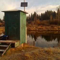
Williamson River below the Sprague River in Chiloquin, OR.
This is a view of a USGS surface water stream gage that contains equipment to monitor discharge at the Williamson River below the Sprague Ruver in Chiloquin, Oregon. The gage house contains a historic stilling well and a device that records the level of water. It also has a water temerature sensor and a turbidimeter.
 - Black (TM)")
Virginia City Highlands Groundwater Investigation: Year 3 Summary
Originally Published by: The Daily News
By: U.S. Geological Survey Director James Reilly
This article has been reprinted or reproduced with the permission of the The Daily News in Longview WA.
SPARROW mappers are interactive tools that allow users to evaluate streamflow and nutrient and sediment conditions as well as the importance of different sources of contaminants in a selected river basin. Data can be visualized at different scales using maps and interactive graphs and tables.
The scarcity or overabundance of water presents some of the most dangerous, damaging and costly threats to human life, ecosystems and property in the form of drought, floods and debris flows.

A multiagency partnership led by the USGS and the Department of Energy seeks to shed light on lithium and other critical mineral resource potential as well as geothermal energy potential in western Nevada

In a joint blog post hosted by the Department of Energy's Office of Energy Efficiency and Rewenable Energy, DOE EERE Assistant Secretary Dan Simmons and Department of the Interior Assistant Secretary for Water and Science Tim Petty announce a new partnership for geothermal energy and critical mineral research in western Nevada.
")
Disasters and emergencies can happen at any time, often without warning. Natural hazards threaten thousands of lives and cause billions of dollars in damage every year throughout the nation.

Study of New Offshore Fault Mapping Related to the 1906 San Francisco Earthquake: In 2019, for the first time ever, scientists comprehensively mapped a previously overlooked offshore section of the San Andreas Fault system which may provide insight on how the fault could rupture in the future.

Earthquakes can be unsettling.

USGS Mineral Resources Program Highlights for the Summer 2020 Edition of the USGS Energy Quarterly Newsletter

For centuries, people have crossed oceans in search of valuable minerals. In recent times, though, increasing attention has been paid to the oceans themselves for their mineral potential, especially rock formations on the seafloor.

A magnitude 6.5 earthquake struck near Tonopah, Nevada, near the California-Nevada border and about 120 miles southeast of Carson City, early this morning on May 15, 2020, at 4:03 am local time (11:03:27 UTC).
U.S. Geological Survey field crews are measuring flooding across the country as spring weather is in full swing. Warming temperatures, increased precipitation and snowmelt have caused moderate to major flooding in the upper Midwest, East Coast, Central Plains and the Southeast portions of the country.
Contacts
Locations

Region 10: California-Great Basin
Phone: 916-278-9551