
- 12201 Sunrise Valley Drive
- Reston, VA 20192, USA
- 703-648-5953
- 1-888-ASK-USGS
- Employee Directory
- Web Chat
We conduct impartial, multi- and interdisciplinary research and monitoring on a large range of natural-resource issues that impact the quality of life of citizens and landscapes of the Southeastern United States and the Caribbean region.

“From the mountains to the coast, the southeastern U.S. contains ecosystems that harbor incredible biodiversity. Many of those ecosystems are already highly at risk from urbanization and other human land-use change. Identifying the ecosystems at risk from climate change will help inform conservation and management to ensure we don’t lose that biodiversity.” (Jennifer Constanza, report author)

New USGS models help predict storm effects on beaches
As the 2016 hurricane season opens, weather forecasters, emergency managers and coastal residents have access to tools developed by the U.S. Geological Survey that predict, more precisely than ever, where beach erosion and beachfront flooding will take place during hurricanes and other storms.

First-of-its-kind survey shows that algal toxins are found nationwide

Disturbances such as tropical storms cause coral mortality and reduce coral cover as a direct result of physical damage. Storms can be one of the most important disturbances in coral reef ecosystems, and it is crucial to understand their long-term impacts on coral populations. The primary objective of this study was to determine trends in disease...
Surveys of juvenile hawksbills around Buck Island Reef National Monument, US Virgin Islands from 1994 to 1999 revealed distributional patterns and resulted in a total of 75 individual hawksbill captures from all years; turtles ranged from 23.2 to 77.7 cm curved carapace length (CCL; mean 42.1 ± 12.3 cm SD). Juveniles concentrated where Zoanthid...
HDgov is an interactive and mobile-responsive online portal to interagency, academic, and non-government resources focused on the human dimensions of natural resource management. The web portal provides easy access to tools, publications, data, and methods that help ensure that the people side of natural resources is considered throughout the entire natural resource management process. The...
The National Park Service (NPS) manages the Nation’s most iconic destinations that attract millions of visitors from across the Nation and around the world. Trip-related spending by NPS visitors generates and supports a considerable amount of economic activity within park gateway communities. USGS economists collaborate with the National Park Service social science program to estimate...
The ultimate success of North American Waterfowl Management Plan (NAWMP) depends on maintaining relevance to stakeholders and society. In order to be relevant, a first step is to better understand what people value in regard to waterfowl and their habitats. Without this information, NAWMP population, habitat, and people objectives may not reflect stakeholder and societal values; and...
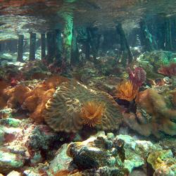
Severe coral bleaching in 2005, followed by a disease outbreak, resulted in severe reef degradation in the US Virgin Islands; the amount of living coral cover at long-term monitoring sites decreased an average of 60%. With climate change, high seawater temperatures are expected to lead to more frequent bleaching episodes and possibly more disease outbreaks. ...
Scientists perform a range of studies that document, assess, and model coastal change, risk, and vulnerability. Studies include historical shoreline change, the geologic structure and history of coastal regions, sediment supply and transport, sea-level rise, and how extreme storm events affect rates and impacts of coastal change.
We study the distribution and hazard potential of coastal and submarine events such as earthquakes and submarine landslides and associated tsunami potential, hurricane induced coastal inundation, extreme storms, sea-level rise and oil and gas spills. We also model development to help evaluate and forecast coastal hazard probability and occurrence.
Our scientists conduct research studies focused on geologic mapping, sampling and understanding of mineral and energy resources and studies of the geologic setting and processes to inform renewable energy development offshore.
We bring together multidisciplinary expertise focused on developing tools and models to improve understanding of how healthy ecosystems function as well as how they respond to environmental changes and human impacts including ecosystem restoration. Research studies address coral reef, coastal wetland, benthic habitat and groundwater resources.
Marine reserves and protected areas in the U.S. Virgin Islands and Puerto Rico encompass a variety of tropical ecosystems, including coral reefs, mangroves, and seagrass beds, but questions remain regarding how effective these areas are at preserving and protecting the habitats and species they encompass. USGS and collaborators address this question by examining the biodiversity and food web...
Coral reefs around the world are exposed to a number of environmental contaminants. USGS researchers investigate the issue of contamination on the reefs around the U.S. Virgin Islands.
On an island in the U.S. Virgin Islands, USGS scientists discover corals are seeking refuge from climate change in mangroves.
USGS researchers tag and track endangered and threatened sea turtles to inform adaptive management strategies in marine protected areas.

USGS data portray selected structures data, including the location and characteristics of manmade facilities. Characteristics consist of a structure's physical form (footprint), function, name, location, and detailed information about the structure. The types of structures collected are largely determined by the needs of the disaster planning and response and homeland security organizations.

Boundaries data or governmental units represent major civil areas including states, counties, Federal, and Native American lands, and incorporated places such as cities and towns.

The National Hydrography Dataset (NHD) and Watershed Boundary Dataset (WBD) are used to portray surface water on The National Map.

The USIEI is a comprehensive, nationwide listing of known high-accuracy topographic and bathymetric data for the United States and its territories. The project is a collaborative effort of the USGS and NOAA with contributions from other federal agencies. The inventory supports the 3D Elevation Program and the Integrated Ocean and Coastal Mapping effort. This resource is updated in Spring and Fall.

The 3DEP products and services available through The National Map consist of lidar point clouds (LPC), standard digital elevation models (DEMs) at various horizontal resolutions, elevation source and associated datasets, an elevation point query service and bulk point query service. All 3DEP products are available, free of charge and without use restrictions.

Orthoimagery data typically are high resolution aerial images that combine the visual attributes of an aerial photograph with the spatial accuracy and reliability of a planimetric map. The National Map offers public domain, 1-meter orthoimagery for the conterminous United States with many urban areas and other locations at 2-foot or finer resolution.

The National Map offers a collection of small-scale datasets, most of which are at 1:1,000,000. The National Map publishes two data collections at one million-scale: one for Global Map users and one for National Map users. In terms of vector geometry, the lines, points, and areas in these data collections are identical. The difference is in the attributes assigned to these features.

Consistent synthesis, integration, storage, and availability of fundamental data is critical to meeting the needs of USGS Science. We develop databases for hydrography, topography, invasive species, water resources, and many other datasets utilized by resource managers.
The 3DEP products and services available through The National Map consist of standard digital elevation models (DEMs) at various horizontal resolutions, elevation source and associated datasets, an elevation point query service and bulk point query service. All 3DEP products are available, free of charge and without use restrictions.

This portal is a “go to” source for maps related to ocean and coastal mapping. Information is organized by geography or region, by theme, and by the year data was published.
Surveys of juvenile hawksbills around Buck Island Reef National Monument, US Virgin Islands from 1994 to 1999 revealed distributional patterns and resulted in a total of 75 individual hawksbill captures from all years; turtles ranged from 23.2 to 77.7 cm curved carapace length (CCL; mean 42.1 ± 12.3 cm SD). Juveniles concentrated where Zoanthid...
Hart, Kristen M.; Sartain-Iverson, Autumn R.; Hillis-Starr, Zandy; Phillips, Brendalee; Mayor, Philippe A.; Roberson, Kimberly; Pemberton, Roy A.; Allen, Jason B.; Lundgren, Ian; Musick, SusannaDisturbances such as tropical storms cause coral mortality and reduce coral cover as a direct result of physical damage. Storms can be one of the most important disturbances in coral reef ecosystems, and it is crucial to understand their long-term impacts on coral populations. The primary objective of this study was to determine trends in disease...
Bright, Allan J.; Rogers, Caroline S.; Brandt, Marilyn E.; Muller, Erinn; Smith, Tyler B.


“From the mountains to the coast, the southeastern U.S. contains ecosystems that harbor incredible biodiversity. Many of those ecosystems are already highly at risk from urbanization and other human land-use change. Identifying the ecosystems at risk from climate change will help inform conservation and management to ensure we don’t lose that biodiversity.” (Jennifer Constanza, report author)
New USGS models help predict storm effects on beaches
As the 2016 hurricane season opens, weather forecasters, emergency managers and coastal residents have access to tools developed by the U.S. Geological Survey that predict, more precisely than ever, where beach erosion and beachfront flooding will take place during hurricanes and other storms.
First-of-its-kind survey shows that algal toxins are found nationwide

A newly published, three-volume “Remote Sensing Handbook” is a comprehensive coverage of all remote sensing topics written by over 300 leading global experts.

Islands used by tropical seabirds are highly vulnerable to sea level rise according to a new study released today.

U.S. Geological Survey hydrologic technicians are currently taking measurements from hundreds of streams and rivers across the western United States as part of a low flow study.

MENLO PARK, Calif.— Smartphones and other personal electronic devices could, in regions where they are in widespread use, function as early warning systems for large earthquakes according to newly reported research.
MENLO PARK, California — Los teléfonos móviles y otros dispositivos electrónicos personales podrían ayudar en las regiones donde se encuentran en uso generalizado, y pueden funcionar como sistemas de alerta para terremotos mayor según la nueva investigación científica recien publicada.

As part of the continued US Topo maps revision and improvement cycle, the USGS will be including mountain bike trails to upcoming quadrangles on a state-aligned basis.
Stronger storms, rising seas, and flooding are placing hundreds of millions people at risk around the world, and big part of the solution to decrease those risks is just off shore. A new study finds that coral reefs reduce the wave energy that would otherwise impact coastlines by 97 percent.
From New Findings on Contaminant Threats in African Dust to the Future of Coral Reefs to Coral Chemical Defenses

Phone: (787) 749-7400


