
Unified Interior Regions
Sprague River Basin, Oregon
Region 9: Columbia-Pacific Northwest
Regions L2 Landing Page Tabs
Our scientists in the Columbia-Pacific Northwest Region conduct impartial, multi- and interdisciplinary research and monitoring on a large range of natural-resource issues that impact the quality of life of citizens of Idaho, Oregon, Washington and western Montana.
News

Trump Administration Officials Tour New Mt. Rainier Lahar Detection Stations
TACOMA, Wash. — Deputy Secretary of the Interior Katharine MacGregor, U.S. Geological Survey Director Jim Reilly, and Counselor to the Secretary Margaret Everson, Exercising the Delegated Authority of the Director of the National Park Service, today visited Mount Rainier National Park to announce the successful permitting and ongoing installation of five new lahar monitoring stations.
Media Advisory: Exclusive Interview Opportunities with Interior Officials to Learn about New Mt. Rainier Lahar Detection Stations
TACOMA, Wash. — What is a lahar and why are they a threat to those who live below Mount Rainier? Journalists are invited to learn about the threat potential posed by lahars from Mount Rainier to local communities and how new USGS lahar monitoring stations will integrate into emergency preparedness and response.

From Volcanoes to Vineyards - New Geologic Map Reveals Portland's Deep History
A new digital geologic map of the greater Portland-Vancouver-Hillsboro metropolitan area of Oregon and Washington being released today will support emergency response, conservation, agriculture and recreation.

White River spinedace (Lepidomeda albivallis) and White River desert suckers (Catostomus clarki) - KFFS
Species Studied
White River spinedace (Lepidomeda albivallis) and White River desert suckers (Catostomus clarki)
")
Pahranagat roundtail chub (Gila robusta) - KFFS
Species Studied
Pahranagat roundtail chub (Gila robusta)

U.S. West Coast and Alaska Marine Geohazards
Marine geohazards are sudden and extreme events beneath the ocean that threaten coastal populations. Such underwater hazards include earthquakes, volcanic eruptions, landslides, and tsunamis.
Devastating earthquakes in Japan (2011) and Chile (2010) that spawned pan-oceanic tsunamis sent a sobering reminder that U.S. coastlines are also vulnerable to natural disasters that originate in...

Dynamic coastlines along the western U.S.
The west coast of the United States is extremely complex and changeable because of tectonic activity, mountain building, and land subsidence. These active environments pose a major challenge for accurately assessing climate change impacts, since models were historically developed for more passive sandy coasts.

Quantitative Disease Ecology
Researchers at the USGS are working on developing new quantitative methods to study disease dynamics in wildlife systems as well as systems at the wildlife-domestic-human interface. Much of our work focuses on how host population structure affects disease invasion, persistence and control in wildlife disease systems. We tackle these issues with a combination of simulation and statistical...

Coastal Change Hazards
Natural processes such as waves, tides, and weather, continually change coastal landscapes. The integrity of coastal homes, businesses, and infrastructure can be threatened by hazards associated with event-driven changes, such as extreme storms and their impacts on beach and dune erosion, or longer-term, cumulative...

PCMSC Marine Facility (MarFac)
Learn about the USGS Pacific Coastal and Marine Science Center Marine Facility, or MarFac

Salmon River Mountains Legacy Mining Studies
The objective of this study is to characterize the regional impact of legacy mining in the context of framework geology for the Salmon Mountains in central Idaho. This objective is addressed through three interrelated tasks: 1) framework geology, 2) watershed biogeochemical processes, and 3) characterization of trace metals in colloids (fine particles suspended in water).
")
Zebrafish (Danio rerio) - FHP
This fish species has become a powerful model organism for the study of vertebrate biology, developmental and genetic research, and more recently infectious disease studies.

USGS science supporting the Elwha River Restoration Project
The Elwha River Restoration Project...
... has reconnected the water, salmon, and sediment of a pristine river and coast of the Olympic Peninsula of Washington. Coordinated by the National Park Service, restoration of the Elwha River included the removal of two large dams that had blocked salmon and sediment passage for almost 100 years. The largest dam removal in U.S. history began in...

Drivers and Impacts of North Pacific Climate Variability
Climate model forecasts indicate an increase in extreme hydrologic events, including floods and droughts, for California and the western U.S. in the future. To better understand what the consequences of this future change in climate may be, USGS scientists are studying the frequency, magnitude, and impacts of past hydroclimate variability and extremes in the region. This project produces well-...

M5.3 2017 Soda Springs, Idaho Sequence
- last updated September 27, 2017 1:40 PST

SPARROW Mappers for the 2012 SPARROW Models for the Pacific region
SPARROW mappers are interactive tools that allow users to explore river streamflow and nutrient and sediment loads and yields and the importance of different sources of contaminants in a particular river basin. Data can be visualized using maps and interactive graphs and tables, and rankings can be shown by state, major watershed, hydrologic unit (HUC), and catchment.
 - Black (TM)")
Data for assessing the susceptibility of groundwater used for drinking water supply from selected principal aquifers of the Western United States, 2004-2018
Groundwater age distribution and susceptibility to natural and anthropogenic contaminants were assessed for selected principal aquifers of the Western United States: the Central Valley aquifer system (CVAL), the Basin and Range basin-fill aquifers (BNRF), the Rio Grande aquifer system (RIOG), the High Plains aquifer (HPAQ), the Columbia Plateau basaltic-rock aquifers (
Drainage basins and characteristics for selected streamgages within the Southern Rockies Landscape Conservation Cooperative domain
Streamflow and basin-characteristic data are needed for a variety of scientific applications including estimation of flow in ungaged basins and hydro-ecological classification of rivers. The U.S. Geological Survey (USGS), in cooperation with the Bureau of Reclamation and the Southern Rockies Landscape Conservation Cooperative (SRLCC), selected a subset of streamgages across the SRLC

Geodetic Data for USGS Benchmark Glaciers: Orthophotos, Digital Elevation Models, and Glacier Boundaries
Since the late 1950s, the USGS has maintained a long-term glacier mass-balance program at three North American glaciers. Measurements began on South Cascade Glacier, WA in 1958, expanding to Gulkana and Wolverine glaciers, AK in 1966, and later Sperry Glacier, MT in 2005. Additional measurements have been made on Lemon Creek Glacier, AK to compliment data collected by the Juneau Ice

High Altitude Weather Station Data at USGS Benchmark Glaciers
Since the late 1950s, the USGS has maintained a long-term glacier mass-balance program at three North American glaciers. Measurements began on South Cascade Glacier, WA in 1958, expanding to Gulkana and Wolverine glaciers, AK in 1966, and later Sperry Glacier, MT in 2005. Additional measurements have been made on Lemon Creek Glacier, AK to compliment data collected by the Juneau Ice

Coastal and Marine Geoscience Data System
Information about scientific data collected through field activities conducted by scientists in the USGS Coastal and Marine Hazards and Resources program

Beach topography and nearshore bathymetry of the Columbia River littoral cell, Washington and Oregon
This data release presents beach topography and nearshore bathymetry data from repeated surveys performed by a team of scientists from the USGS, Washington State Department of Ecology, and Oregon State University in the Columbia River littoral cell (CRLC), Washington and Oregon. The CRLC extends approximately 165 kilometers between Point Grenville, WA, and Tillamook, OR.

Puget Sound Real-Time Water-Level Data
The chart shows the most recent 7 days of data at all Puget Sound water level sites with available data. Use mouse scroll wheel to zoom and drag to pan. Sites include Bellingham, Oak Harbor, Edmonds, Lofall, Steilacoom, and Olympia.

National Water Information System (NWIS) Mapper
The NWIS mapper provides access to over 1.5 million sites contained in the USGS National Water Information System (NWIS), including sites where current and historical surface-water, groundwater, springs, and atmospheric data has been collected. Users can search by site type, data type, site number, or place.
Nearshore bathymetry data from the Elwha River delta, Washington, July 2017, collected from personal watercraft
This part of the data release presents bathymetry data from the Elwha River delta collected in July 2017 using two personal watercraft (PWCs). The PWCs were equipped with single beam echosounders and survey-grade global navigation satellite system (GNSS) receivers.
Topography data from the Elwha River delta, Washington, July 2017
This part of the data release presents topography data from the Elwha River delta collected in July 2017. Topography data were collected on foot with global navigation satellite system (GNSS) receivers mounted on backpacks.

Wave observations from bottom-mounted pressure sensors in Bellingham Bay, Washington from Dec 2017 to Jan 2018
RBRduo pressure and temperature sensors (early 2015 generation), mounted on aluminum frames, were moored in shallow (< 6 m) water depths in Bellingham Bay, Washington, to capture wave heights and periods. Continuous pressure fluctuations are transformed into surface-wave observations of wave heights, periods, and frequency spectra at 30-minute intervals.

This map shows the provinces assessed by the USGS for undiscovered oil and gas resources.

Scientists at WERC's Dixon Field station have fitted Cinnamon Teal with GPS backpacks. Using R, the telemetry locations are displayed on an image every two weeks.

Scientists at WERC's Dixon Field station have fitted Cinnamon Teal with GPS backpacks. Using R, the telemetry locations are displayed on an image every two weeks.

Scientists at WERC's Dixon Field station have fitted Cinnamon Teal with GPS backpacks. Using R, the telemetry locations are displayed on an image every two weeks.

The 3DEP products and services available through The National Map consist of standard digital elevation models (DEMs) at various horizontal resolutions, elevation source and associated datasets, an elevation point query service and bulk point query service. All 3DEP products are available, free of charge and without use restrictions.

The image is a mosaic of nine scenes from Landsat 5 at a resolution of 30 meters on 07/22/2005, 08/26/2006, 06/17/2007, 07/05/2007, 08/18/2009, 08/27/2009, and 09/26/2009.

The Pedestrian Evacuation Analyst is an ArcGIS extension that estimates how long it would take for someone to travel on foot out of a hazardous area that was threatened by a sudden event such as a tsunami, flash flood, or volcanic lahar. It takes into account the elevation changes and the different types of landcover that a person would encounter along the way.

Model archive for Wood River Valley groundwater-flow model
The R package wrv is for processing the groundwater-flow model of the Wood River Valley (WRV) aquifer system, south-central Idaho. The groundwater-flow model is described in the associated model report and model archive. Included in the package is MODFLOW-USG version 1.3, a U.S. Geological Survey (USGS) computer code that solves the groundwater-flow equation.

The Shoreline Management Tool—An ArcMap Tool for Analyzing Water Depth, Inundated Area, Volume, and Selected Habitats, with an Example for the Lower Wood River Valley, Oregon

Cableway and stream gage on Blue River, OR
Cableway (foreground) and stream gage (background) on Blue River at Blue River, Oregon (Site number 14162200)

Cableway on North Santiam River at Niagara, Oregon
Cableway on North Santiam River at Niagara, Oregon (Site number 14181500)

Stream gage on South Fork McKenzie River near Rainbow, Oregon
Stream gage on South Fork McKenzie River near Rainbow, Oregon (Site number 14159500)

Stream gage on Blue River at Blue River, Oregon
Stream gage on Blue River at Blue River, Oregon, (Site number 14162200)

Stream gage on McKenzie River near Vida, Oregon
Stream gage on McKenzie River near Vida, Oregon (Site number 14162500)

USGS Director Jim Reilly gives a speech
The USGS Forest and Rangeland Ecosystem Science Center (FRESC) held a groundbreaking ceremony on August 25, 2020 at the Idaho Water Science Center (IDWSC) in Boise, Idaho. FRESC is moving their Snake River Field Station, presently located on the Boise State University campus, to the IDWSC campus and building a new facility for the USGS Pacific Northwest environmental DNA
...
Setting up a bat acoustic monitoring station
White-nose syndrome has been detected in Washington. USGS scientist are helping the NPS design and evaluate bat sampling protocols for their Pacific Northwest parks.

Verifying Bridge Scour Sonar Accuracy
Hydrologic technician Russ Miller navigates a remote-controlled acoustic Doppler current profiler into position to measure streeambed elevation at a highway bridge over the Payette River near Letha, Idaho. Technicians from the USGS Idaho Water Science Center used the ADCP measurements to verify the accuracy of two sonar devices installed on the bridge that transmit real-
...
Yellowstone Volcano Observatory Monthly Update: January 2, 2020
Mike Poland, Scientist-in-Charge of the Yellowstone Volcano Observatory, gives an overview of activity at Yellowstone during 2019, with an emphasis on the month of December.

Map showing ice cover in the Yellowstone region
Map showing ice cover in the Yellowstone region. Light shaded areas bounded by black and red lines indicate areas covered during the Pinedale (about 20,000-15,000 years ago) and Bull Lake (about 150,000 years ago) glaciations, respectively. Blue lines are contours in thousands of feet on the maximum reconstructed Pinedale glacier surface. The circled numbers schematically
...
Image of the Week - Festive Fields in North Carolina
The smell of a fresh cut Christmas tree can evoke visions of majestic evergreen forests teeming with winter wildlife. In truth, more than half of U.S. Christmas trees come from farms in Oregon, North Carolina, or Michigan. Cut Christmas Trees area commodity, tracked by the U.S. Department of Agriculture just like corn or soybeans. These USDA aerial images show tree harvest
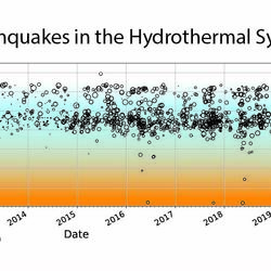
Mount Rainier: Earthquakes in the Hydrothermal System
Earthquakes at Mount Rainier from 2010 to 2019. As shown in the graphic, fluids from the magmatic system beneath the volcano rise through existing cracks and weaknesses in the crust. Along with rainwater and ice/snow melt, these fluids combine to create a hydrothermal system within the volcano. When pressurized fluids move along faults in the shallow subsurface, they
...TACOMA, Wash. — Deputy Secretary of the Interior Katharine MacGregor, U.S. Geological Survey Director Jim Reilly, and Counselor to the Secretary Margaret Everson, Exercising the Delegated Authority of the Director of the National Park Service, today visited Mount Rainier National Park to announce the successful permitting and ongoing installation of five new lahar monitoring stations.
TACOMA, Wash. — What is a lahar and why are they a threat to those who live below Mount Rainier? Journalists are invited to learn about the threat potential posed by lahars from Mount Rainier to local communities and how new USGS lahar monitoring stations will integrate into emergency preparedness and response.
A new digital geologic map of the greater Portland-Vancouver-Hillsboro metropolitan area of Oregon and Washington being released today will support emergency response, conservation, agriculture and recreation.

USGS scientists are providing important information about off-channel features of the Willamette River, which provide habitat for many fish species including salmonids. This information will fill gaps in the data needed to effectively manage the Willamette River system.

Originally Published by: The Daily News
By: U.S. Geological Survey Director James Reilly
This article has been reprinted or reproduced with the permission of the The Daily News in Longview WA.

SPARROW mappers are interactive tools that allow users to evaluate streamflow and nutrient and sediment conditions as well as the importance of different sources of contaminants in a selected river basin. Data can be visualized at different scales using maps and interactive graphs and tables.

On Labor Day, September 7, 2020, dry conditions combined with unusually strong summer winds resulted in several fires in western and southern Oregon. These fires have caused property damage and fatalities.

The scarcity or overabundance of water presents some of the most dangerous, damaging and costly threats to human life, ecosystems and property in the form of drought, floods and debris flows.
")
Disasters and emergencies can happen at any time, often without warning. Natural hazards threaten thousands of lives and cause billions of dollars in damage every year throughout the nation.

USGS Mineral Resources Program Highlights for the Summer 2020 Edition of the USGS Energy Quarterly Newsletter
U.S. Geological Survey field crews are measuring flooding across the country as spring weather is in full swing. Warming temperatures, increased precipitation and snowmelt have caused moderate to major flooding in the upper Midwest, East Coast, Central Plains and the Southeast portions of the country.

Budget Focuses on Bringing Science, Facilities, and Infrastructure into the 21st Century
Contacts
Locations


Idaho Water Science Center
Phone: Phone: (208) 387-1300
Fax: (208) 387-1372

Washington Water Science Center
Phone: (253) 552-1600
Fax: (253) 552-1581

Western Fisheries Research Center (WFRC)
Phone: (206) 526-6282
Fax: (206) 526-6654

Oregon Water Science Center
info-or@usgs.gov
Phone: (503) 251-3200
Fax: (503) 251-3470

USGS Volcano Science Center
Phone: 360-993-8900

Forest and Rangeland Ecosystem Science Center (FRESC) Headquarters
fresc_outreach@usgs.gov
Phone: 541-750-1030
Fax: 541-750-1069

Northwest Climate Adaptation Science Center

USGS Cascades Volcano Observatory (CVO)
vhpweb@usgs.gov
Phone: 360-993-8900
Fax: 360-993-8980
")
Columbia River Research Laboratory
Phone: (509) 538-2299
Fax: (509) 538-2843

Oregon Cooperative Fish And Wildlife Research Unit

Idaho Water Science Center - Idaho National Laboratory Project Office
Phone: 208-526-2438

Forest and Rangeland Ecosystem Science Center (FRESC) Snake River Field Station
fresc_outreach@usgs.gov
Phone: 208-426-5200
Fax: 208-426-5210

Forest and Rangeland Ecosystem Science Center (FRESC) Olympic Field Station
fresc_outreach@usgs.gov
Phone: 360-565-3041

Forest and Rangeland Ecosystem Science Center (FRESC) Cascadia Field Station
fresc_outreach@usgs.gov
Phone: 206-616-1874
Fax: 206-685-0790

Forest and Rangeland Ecosystem Science Center (FRESC) Corvallis Research Group
fresc_outreach@usgs.gov
Phone: 541-750-1030

Klamath Falls Field Station
Phone: (541) 273-8689
Fax: (541) 273-8692

Marrowstone Marine Field Station
Phone: (360) 385-1007
Fax: (360) 385-7207

Idaho Water Science Center - Boise Field Office
Phone: (208) 387-1300
Fax: (208) 387-1372

Idaho Water Science Center - Post Falls Field Office
Phone: 208-773-4938

Idaho Water Science Center - Groundwater Training Facility
Phone: 208-387-1392

Northwest Washington Field Office
Phone: (360) 312-8155 x2001
Fax: (360) 312-8565
Medford Field Office
Phone: 541-776-4256
Fax: 541-776-4257
Klamath Falls Field Office
Phone: 541-273-8689

Mid-Columbia Field Office
Phone: (509) 735-3739
Fax: (509) 735-3723

Upper Columbia Field Office
Phone: (509) 353-2649

Idaho Water Science Center - Idaho Falls Field Office
Phone: 208-529-4287