
Science Explorer
Exploring: Web Map Services

The National Map offers a series of composite base maps that combine layers into tile cache services with the cartographic richness of multiple data sources. The following base maps are available:
- ...

The projection used for all tiled base map services in The National Map is the World Geodetic System 1984 (WGS 84) Web Mercator (Auxiliary Sphere) so that base map services can be used in combination with other common viewers. See ...

Since the USGS obtains most boundaries, structures, and transportation data from external sources, the frequency of updates depends on the release schedule of the source products.
- Boundaries - updates are...

An Application Programming Interface (API) is a way for developers to interface with data.
The National Map (TNM) has one API (TNMAccess) that provides access to all TNM downloadable...

The area of coverage of any particular standard 3D Elevation Program (3DEP) DEM product is generally determined by the availability of source elevation data of similar or higher resolution. For example, the 1/3 arc-second layer is available for only portions of Alaska where higher...

When building a cache for a tiled base map service, file sizes for tiles increase four times with each zoom scale. The storage size required to cache data at scales larger than 1:18,000 is greater than the USGS can currently manage. For example, just to store data down to 1:18,000 requires a cache of over 39 million tiles. High-performing dynamic...

A complete list of service URLs can be found at The National Map-Service Endpoints website, which contains available REST, WMS, WMTS (cached base maps only), WFS, WCS, and other service links.

Geopgraphical Information Systems Information and Data

The USGS developed the SPARROW (SPAtially Referenced Regressions On Watershed attributes) modeling framework to relate water-quality monitoring data to upstream nutrient and sediment sources and watershed characteristics. The mapper can be used to evaluate alternative hypotheses about the relative importance of various pollutant sources.

A Geographic Information System (GIS) is a computer system that analyzes and displays geographically referenced information. It uses data that is attached to a unique location.
Most of the information we have about our world contains a location reference: Where are USGS streamgages located? Where was a rock sample collected? Exactly where are all...

Composite base maps are recached about once a year. Although data in dynamic service overlays are ideally updated quarterly, it can sometimes take up to six months. Please note that there will be times when composite base maps and dynamic service overlays are not in synchronization because of a difference in refresh cycles.
Subscribe to the...

Digital elevation data are available through The National Map Download Client. Click the “How To” link at the top of the viewer for detailed instructions on how to find and download data. There is a seperate site for Services.
The 3D Elevation...

Over 40 National Map Web Map Services are available for use in your applications. The Map Service List, Uptime Status, and Simple Notification Service (SNS) for keeping current on any upcoming service changes are all available from this page.

Graphics showing 3DEP product availability and recent updates can be found on the 3DEP Product Availability Web page. Areas containing recent updates are refreshed monthly. Spatial metadata shapefiles showing the updated areas for each product are also available for download from...

https://www.usgs.gov/faqs/what-sources-data-are-used-produce-standard-3d-elevation-program-3dep-dems
3DEP standard DEMs are produced from the highest quality elevation sources within the data holdings of the USGS National Geospatial Program. As of 2015, about 25% of the conterminous U.S. coverage is from high resolution lidar and photogrammetric source, while the remainder of the conterminous U.S. and Hawaii coverage is from USGS topographic map...

Specific data for current mountain peak elevations do not exist at USGS other than what was previously published in an Elevations and Distances in the United States booklet. A way to determine an approximate elevation at a specific point is to use the spot elevation tool query in The...

Lesson 5: Using The National Map Web Services in ArcMap - This video provides an overview and demonstrates how to use The National Map's web services in a mapping application.
Web Services
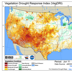
The Drought Monitoring datasets are available as OGC Web Map Services (WMS). You can access the services using the below links.
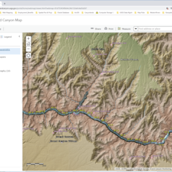
Grand Canyon Map Portal
Click to launch the Grand Canyon Map Portal hosted by the U.S. Geological Survey's Grand Canyon Monitoring and Research Center (GCMRC). GCMRC is part of the River Ecosystem Science branch of the Southwest Biological Science Center (SBSC) and is based in Flagstaff, Arizona.

The Geospatial team of Grand Canyon Monitoring and Research Center maintains an enterprise GIS system built upon ESRI ArcGIS Server and Portal applications. From this platform, geospatial content can be consumed in a variety of forms, from custom-built web applications to content hosted on ESRI's ArcGIS Online to direct access of web map services...