
Wildfire Hazards
Home
Programs L2 Landing Page
We carry out a wide range of wildfire-related science activities that span multiple USGS mission areas, including landscape ecology studies, geospatial support for fire response, burned area hydrology, and post-fire debris flow warnings.
News

Natural Hazards Newsletter - Inaugural Issue - Vol. 1 | Issue 2021-Winter
We introduce the USGS Natural Hazards newsletter. In this issue: A new geonarrative about the 2019 Ridgecrest earthquake, Potential landslide in Alaska, Subduction Zone Science, Post-wildfire debris flow assessments, new @USGS_Quakes Twitter account, Mapping faults in Puerto Rico, Coastal Change Top Story, Photo Round Up and more!

Fire Science Critical for Combating Wildfires Out West
Visit our USGS Wildland Fire Science webpage to learn how USGS science is making a difference.

Wildfire Support from 438 Miles Above
USGS Fire Science is fundamental to understanding the causes, consequences, and benefits of wildfire and helps prevent and manage larger, catastrophic events. USGS scientists and programs provide information and develop tools that are widely used by stakeholders to make decisions before, during, and after wildfires across the nation.
")
Satellite Data Applications for Fire Science
Our satellite remote sensing research and applications are essential for providing required data for mapping fire fuels, assessing fire effects, monitoring fire danger, and measuring progress in implementing the National Fire Plan. Land management agencies, scientific communities, and citizenry affected by wildland fires can benefit from our work.
Monitoring Trends in Burn Severity (MTBS)
MTBS is a multi-year project designed to map the burn severity and perimeters of fire across all lands of the United States for the period spanning 1984 through 2010. The data generated by MTBS will be used to identify national trends in burn severity and evaluate the effectiveness of the National Fire Plan and Healthy Forest Restoration Act.
Post-Wildfire Landslide Hazards
Post-fire landslides are particularly hazardous because they can occur with little warning, can exert great force on objects in their paths, can strip vegetation, block drainage ways, damage structures, and endanger human life. Our focus is to develop tools and methods for the prediction of post-wildfire landslide activity and hazard delineation.
Fire Ecology
Ecosystems throughout the western U.S. are often dependent on a particular fire regime to reduce hazardous fuels and rejuvenate forests or even guide evolution of plant life and regulate ecological communities. Today fire’s role is more complicated. For example, fire can favor invasive plants and these invaders may, in turn, alter the fire regime.
Change and Disturbances
Organisms have different abilities to adapt to disturbances. Some disturbances can be catastrophic to one species and inconsequential to another. Our Forest and Rangeland Ecosystem Science Center (FRESC) scientists are studying the effects of disturbances on species, biogeochemistry, water quality, habitat connectivity and landscape patterns.

LANDFIRE Data Distribution
Map interface to view and download LANDFIRE data sets, receive alerts and notifications.
Wildfires: GEOMAC
Maps of current fire locations and perimeters in the conterminous 48 States and Alaska.

Emergency Assessment of Post-Fire Debris-Flow Hazards
We conduct post-fire debris-flow hazard assessments for select fires in the Western U.S. We use geospatial data related to basin morphometry, burn severity, soil properties, and rainfall characteristics to estimate the probability and volume of debris flows that may occur in response to a design storm.

I Am A...Fire Ecologist
Welcome to the "The I Am A..." series. This is the third video in a series of USGS whiteboard animations that highlight USGS careers. The concept is to show "what society (or my mom) thinks I do" compared with "what I really do." One image captures a more whimsical representation of a "scientist" in the field and the second demonstrates a more accurate representation of

Eyes on Earth Episode 24 - Wildfire Risk to Communities
The U.S. has plenty of data on wildfire risk. There are local and regional risk assessments, complex datasets like LANDFIRE and tracking tools like the EROS Fire Danger Monitor, as well as a host of resources and research projects devoted to the subject. But much of that information is steeped in the language of fire science and difficult to comprehend for those outside it

RestoreNet Partner Meeting
Land managers representing National Park Service, Bureau of Land Management, US Forest Service, Navajo Nation, private ranches and farms attend the first RestoreNet stakeholder meeting at the USGS Southwest Biological Science Center in February 2020.
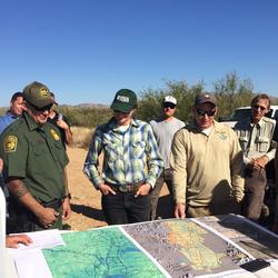
Managing Fire on the US Mexico Borderlands
RAMPS met with DOI Office of Wildland Fire, US Customs and Border Patrol, and US Fish & Wildlife Service staff at Buenos Aires National Wildlife Refuge in southern AZ last November. The group is developing tools to reduce wildfire risk, conserve wildlife habitat and natural resources, and increase safety and security of border operations.
...
Image of the Week - Southern California Wildfires Update
After a month, the wildfires of Southern California are nearly contained. Landsat 8 imagery shows the dramatic burn scars left behind.
At the USGS EROS Center, we study land change, operate the Landsat satellites, and maintain the longest, continuously acquired collection of images of the Earth's land surface.
USGS EROS Center (

Understory - EROS LiDAR
Example of lidar-derived metric products of canopy structure. A) Image showing an area characterized by varied forest strands. (Red box shows from where profile data in E area taken.) B) Lidar-derived maximum canopy height. C) Lidar-derived height of low- to medium-height vegetation beneath the overstory canopy. D) Density of vegetation at 2-4 m within the canopy. Note
...
Prescribed Burn — Tall Timbers Research Station, FL (Drone)
Drone footage of a prescribed fire at Tall Timbers Research Station, Tallahassee, Florida (April 19, 2017).

Post-wildfire Flood and Debris Flow: 2014 Silverado Fire
In 2014, the Silverado Fire burned approximately 4 km^2 in Orange County, California. After the fire, the USGS installed an automated rain-triggered camera to monitor post-wildfire flooding and debris flow at the outlet of a small 0.6 km^2 basin within the burn area. This video shows the initial surge and peak flow triggered by an intense rainstorm on July 19, 2015. The

Living with Fire: Chaparral Removal
Southern California's fire ecology is unlike that of anywhere else in the United States. Fire control strategies developed for mountain forests don't have the same results here. So can science help uncover new answers to help Southern California communities manage and live with wildfires? This 10 minute film showcases ongoing USGS research supporting agencies on the
Fire Science Critical for Combating Wildfires Out West
Visit our USGS Wildland Fire Science webpage to learn how USGS science is making a difference.
Wildfire Support from 438 Miles Above
USGS Fire Science is fundamental to understanding the causes, consequences, and benefits of wildfire and helps prevent and manage larger, catastrophic events. USGS scientists and programs provide information and develop tools that are widely used by stakeholders to make decisions before, during, and after wildfires across the nation.

RAMPS Newsletter - Spring 2020 Edition
This season's edition of the Restoration Assessment and Monitoring Program for the Southwest Newsletter contains recent program highlights including research updates from our RestoreNet experiment, recently awarded funding, field updates and more.
To subscribe to our newsletter, please visit: ...

USGS Hazard Science – Understanding the Risks is Key to Preparedness
Learn About USGS Hazards Science and More About National Preparedness Month: The very nature of natural hazards means that they have the potential to impact a majority of Americans every year. USGS science provides part of the foundation for emergency preparedness whenever and wherever disaster strikes.

Fast Fire Facts from USGS
You’ve got questions about USGS fire science. We’ve got answers.

Science for a Risky World: A USGS Plan for Risk Research and Applications – USGS publishes strategic plan for examining risk
USGS explores opportunities to advance its capabilities in risk assessment, mitigation, and communication in new strategic plan.
")
USGS Science – Leading the Way for Preparedness
Learn About USGS Hazards Science and More About National Preparedness Month: The very nature of natural hazards means that they have the potential to impact a majority of Americans every year. USGS science provides part of the foundation for emergency preparedness whenever and wherever disaster strikes.

Follow National Wildfire Information in the Palm of Your Hand: GeoMAC Goes Mobile
The public can now access information about active wildfires across the country using a smartphone.

EROS Work Called 'Critical' to Wildfire Mapping, Response
Remotely-sensed data key to response in tracking danger in areas like Montecito

USGS on Fire: It’s not a matter of “if,” it’s a matter of “more fire science data please!”
Visit our new USGS fire webpage to learn how USGS fire science is making a difference

Point and Click to Track Wildfire Activity in the United States
Keep tabs on wildfire activity via this U.S. Geological Survey website, GeoMAC.

Igniting a New Trend in Public Safety
U.S. Geological Survey scientists and partners are taking technology to the next level, using unmanned aircraft systems (UAS), commonly called drones, to acquire both fire intensity and emissions data during prescribed burns.