
Multimedia Gallery
Images Carousel
Images
Explore our planet through photography and imagery, including climate change and water all the way back to the 1800s when the USGS was surveying the country by horse and buggy.

Swath bathymetric image of the Elliott’s Crater explosion crater
Swath bathymetric image of the Elliott’s Crater explosion crater in Yellowstone Lake. Inset shows location of the crater and the swath image (red box) within the northern part of the lake.

Ash cloud simulation for a small eruption of Mount St. Helens
If Mount St. Helens were to have a small eruption today (similar in size to its July 22, 1980 eruption), this simulation shows the ash cloud extent.

Ash cloud simulation for moderate sized eruption of Mount St. Helens
If Mount St. Helens were to have a moderate sized eruption today (similar to Mount Spurr, Alaska, August 18, 1992), this model shows the ash cloud extent.

Ash cloud simulation for an eruption size of 5/18/1980 Mount St Helens
If Mount St. Helens (Washington) were to have an eruption today the same size as that of May 18, 1980, this model simulation shows the ash cloud reach.

Productivity of Black Oystercatchers in Southwest Alaska
The black oystercatcher, a keystone species in nearshore ecosystems, plays an important role in structuring nearshore systems and is highly susceptible to human disturbance. Current inventory and monitoring efforts may not adequately address the information needs for estimating long-term trends for this species. To address these issues, the goal of this research is to
...
Research drilling in Yellowstone National Park
Research drilling in Yellowstone National Park. (A) is an image from Fenner (1936) of the drilling setup in the Upper Geyser Basin during the 1929 field season. (B) is an image from White et al. (1975) of the USGS drill rig set up in the Norris Geyser Basin in 1967-68 during a steam eruption.
Scanning electron microscope image of Yellowstone drill core
The right side of the figure is an image of a small piece of the Y-9 core from the USGS 1967-68 drilling expedition to Yellowstone National Park. The black area was analyzed using a scanning electron microscope (SEM) at the University of Wyoming to determine mineralogy and dispersion of elements. The black and white photo is an SEM image of the alteration mineral
...
Wave conditions and probability of burial during munitions experiment
A) Conditions during a 2015 munitions mobility experiment in Duck, NC, and B) cartographic visualization of hindcast probability of munitions’ complete burial during the experiment.

National Geographic Photographed Sea Lamprey at HBBS
Keith Ladzinski (right), photographer for the National Geographic Magazine December 2020 cover story on the Great Lakes, along with assistant Angie Paine (left), photographed live sea lamprey at the GLSC’s Hammond Bay Biological Station during September 2019. An interview of Ladzinski, during which he discussed his visit to the station, aired on NPR Michigan
...
Distribution of Chronic Wasting Disease in North America
Distribution of Chronic Wasting Disease in North America, updated December 17, 2020.

HBBS Participates in Brave Wilderness Episode Shoot
Brave Wilderness host, Coyote Peterson, holds his hands in a tank of live sea lamprey while filming the first of two sea lamprey-focused episodes for the show’s YouTube channel. GLSC communications associate, Dr. Andrea Miehls, assisted the Brave Wilderness team while filming in multiple remote locations across northeastern Michigan.

Vessels Sampling in a River in Ohio
Vessels like this use various sampling methods to collect fish at all life stages, adult, larvae, and eggs.

Diver visits experimental elkhorn coral in Dry Tortugas National Park
The U.S. Geological Survey is conducting research to guide the restoration and recovery of the threatened elkhorn coral, Acropora palmata, in Dry Tortugas National Park and throughout the western Atlantic. In this photograph, research marine biologist Ilsa Kuffner is doing maintenance on a USGS “calcification station”. The USGS has established these stations,
...
USGS scuba diver on a coral reef in Dry Tortugas National Park
The U.S. Geological Survey is conducting research to guide the recovery of the threatened Elkhorn coral, Acropora palmata, in Dry Tortugas National Park and throughout the western Atlantic. A small Elkhorn colony, raised from a fragment collected after a storm, is shown here in the foreground after it was cemented to the reef to establish a new coral population.
...
Standard Fish Sampling Techniques
Examining environmental deoxyribonucleic acid (eDNA) in water samples has demonstrated promise for identifying fish species present in water bodies. However, whether or not this same approach can be used to assess relative abundance, biomass, and species composition in large (greater than [>] 200-hectare) waterbodies is unclear. This research compared
...
Trace 1310 GC with a TSQ 9000 triple quadrupole MS (Thermo Scientific)
Trace 1310 GC with a TSQ 9000 triple quadrupole MS (Thermo Scientific)
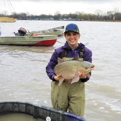
Tracking the Movement of Grass Carp in the Sandusky River, 2016
Nicole King (University of Toledo graduate student) holding a Grass Carp. The Ohio Department of Natural Resources and Michigan State University responded to a report from a commercial fisherman that grass carp were being captured in the Sandusky River. Researchers captured, tagged, and released grass carp to track their movements.

Map of Yellowstone Lake seismic swarms in 2008-2009 and 2020
Map of earthquakes that occurred beneath Yellowstone Lake as parts of seismic swarms in 2008-2009 (green) and 2020 (red). Orange line is the boundary of Yellowstone Caldera, which formed 631,000 years ago.

Seismicity rates for Yellowstone Lake earthquake swarms
Rate of earthquake occurrence for the 2008-2009 Yellowstone Lake swarm (green) and 2020 swarm (red).

KWcam webcam animated GIF December 2, 2020
ANIMATED GIF: At Kīlauea summit, the KWcam webcam recorded several small color changes along the lake margin following rockfalls which impacted the lake surface. These rockfalls immediately followed a M3.1 earthquake Wednesday evening, December 2, at 5:59 p.m. HST. This animated image file (GIF) continuously loops two consecutive webcam images from 5:50 p.m. and 6:00 p.m.
...
KWcam webcam image from December 2 at 6:00 p.m. HST
KWcam webcam image from December 2 at 6:00 p.m. HST, immediately following a M3.1 earthquake at Kīlauea summit. Several rockfalls down the talus slope impacted the summit water lake, causing some brief localized color changes of the lake surface (circled in yellow).

moon setting over Mauna Loa's broad Northeast Rift Zone
This photo was taken from the west rim of Kīlauea caldera at dawn, and shows the moon setting over Mauna Loa's broad Northeast Rift Zone. USGS photo by M. Patrick.

November 2020 Active Groundwater Level Network Animation
The USGS Active Groundwater Level Network includes about 20,000 wells that have been measured by the USGS or USGS cooperators at least once within the past 13 months. The animation shows a daily snapshot of water-level statistics in the network for November 2020.
Refer to the
...
Tephra layers preserved at the summit of Kīlauea
Tephra layers preserved at the summit of Kīlauea from at least three different eruptions. Deposits below the top of the scale are predominantly juvenile and deposits above it containing many lithics. Notice the larger size of the yellow pumice clasts compared to the much denser and finer grey lapilli and ash surrounding them from 7 to 18 on the scale. The scale is in cm.
...
Collecting samples to inform elkhorn coral restoration strategies
Ohio State University graduate student Ann Marie Hulver and postdoc Dr. Leila Chapron from Dr. Andrea Grottoli's lab process samples collected for a study on elkhorn coral growth in the Florida Keys. These researchers are collaborating with Dr. Ilsa Kuffner of the St. Petersburg Coastal and Marine Science Center to
...
Lidar hillshade map of part of the Blackfoot Volcanic Field
Lidar hillshade map of part of the Blackfoot Volcanic Field, showing rhyolite domes and fault scarps.

Volcanic rocks in SE Idaho that are related to the Yellowstone hotspot
Map of southeastern Idaho showing volcanic rocks related to the Yellowstone hotspot. Basalt is shown in red and rhyolite in yellow. Blue circles indicate the location of past Yellowstone calderas; caldera names and approximate ages are shown (Ma = million years old).

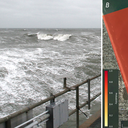
Sunset State Beach Variance Image
Far out, man... where science meets art
This is an image produced from one of two video cameras, which were installed to overlook the coast at Sunset State Beach in Watsonville, California. The cameras are part of the USGS Pacific Coastal and Marine Science Center’s
...
Landsat 8 image showing northeast Mongolia
Landsat 8 image acquired on November 19, 2020 over northeast Mongolia (Path 127 Row 26). The image is shown using the shortwave infrared 1, near infrared, and red bands (bands 6,5,4).
Landsat Scene ID LC08_L1TP_127026_20201119_20201119_01_RT

White River spinedace
White River spinedace. Photo taken Wayne E. Kirch Wildlife Management Area, Lund, NV.

USGS passive integrated transponder (PIT) detection antenna
Passive integrated transponder detection antenna located in the Flag Springs Complex in eastern Nevada. This is the only place on earth where White River spinedace still exist.

White River desert sucker
White River desert sucker. Photo taken Wayne E. Kirch Wildlife Management Area, Lund, NV.

White River spinedace
White River spinedace. Photo taken Wayne E. Kirch Wildlife Management Area, Lund, NV.

Erosion of dunes following Tropical Storm Eta
Tropical Storm Eta affected beaches along Florida's Gulf Coast in November 2020. Some dunes were eroded up to several feet due to the high water levels associated with the storm. Madeira Beach is home to many people and animals, and erosion events such as this can affect both habitat and infrastructure. The USGS Coastal Change Hazards
...
White River spinedace
White River spinedace. Photo taken Wayne E. Kirch Wildlife Management Area, Lund, NV.

Temperature records from sites on Yellowstone Lake bottom
Year-long (August 2017 to August 2018) temperature records from two hydrothermal vents (“A” and “B”) in the Deep Hole area of Yellowstone Lake.

Salt Marsh Pond and Tidal Creek, Plum Island, MA
Salt marsh pond (left) and tidal creek (r), Plum Island, MA

Lake at Kīlauea's summit
Dark brown colors dominated the central and western portions of the lake at Kīlauea's summit. The greenish hues were present in areas that appear to be zone of hot water influx into the lake. USGS photo by M. Patrick.

White-fronted goose flies over a nesting area near Point Lonely, AK
A white-fronted goose flies over a nesting area near Point Lonely, Alaska. For more information about this USGS study read "Effects of industrial and investigator disturbance on Arctic-nesting geese" at: https://pubs.er.usgs.gov/publication/70192845

Weighing type precipitation gage and new radar-based sensor
The Wolverine Glacier weather station was installed in 1968, and at 3250 ft is the highest elevation long-term weather record on the Kenai Peninsula. On October 19, 2020, USGS scientists upgraded the power system to a Lithium battery bank and installed a radar-based precipitation sensor (Lufft WS-100) to compare with the weighing based precipitation gage. From this angle
...
Blackfeet Hydrologic Assessment Webpage Map
Blackfeet Hydrologic Assessment webpage map

Tropical Storm Eta effects on Madeira Beach, Florida
Tropical Storm Eta had effects on Florida's Gulf Coast beaches, including dune erosion and overwash. This image from the coast cam at Madeira Beach, Florida captured high water levels and resulting overwash of sand onto the patio of the Shoreline Resort. The USGS Coastal Change Hazards team works to predict these types of events to
...
Kīlauea's summit lake between rain showers
A quick visit to the western caldera rim provided brief views of Kīlauea's summit lake between rain showers. The lake colors were particularly vibrant today, with a deep blue-green color in the western end (bottom of photo), with dark brown near the center. USGS photo by M. Patrick.

Landsat 8 image showing southwest Morocco
Landsat 8 image acquired on November 11, 2020 over southwest Morocco (Path 203 Row 40). The image is shown using the shortwave infrared 2, red, and blue bands (bands 7,4,2).
Landsat Scene ID LO08_L1TP_203040_20201107_20201111_01_T1

Measuring water chemistry in Double Keyhole Cave, FL
Robert Scharping, a post-doctoral fellow jointly appointed by the USGS and the Woods Hole Oceanographic Institution (WHOI) measures water chemistry 40’ underwater and underground in Double Keyhole Cave near the coastline of Tampa Bay Florida. Robert is identifying the microbes and chemical conditions supporting chemosynthetic production of organic matter that is expelled
...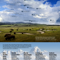
Department of the Interior Bison Conservation Initiative 2020
Bison
Since the late 19th century, the Department of the Interior, in collaboration with others, has been a leader in shared conservation stewardship of bison and manages...
- 11,000 plains bison
- 19 herds
- On 4.6 million acres of the National Park Service, U.S. Fish and Wildlife Service, & Bureau of Land Management
- In 12 states

TNMCorps Mapping Challenge: City/Town Halls in IL & MO (IncPl StLouis)
TNMCorps Mapping Challenge: The labeled communities on this map represent incorporated places in the St. Louis metropolitan area (i.e., IL and MO) that have a population greater than 1,000 but do not yet have a city/town hall within their corporate boundaries.

Close up of the new radar precipitation sensor on the top of the pole
The Wolverine Glacier weather station was installed in 1968, and at 3250 ft is the highest elevation long-term weather record on the Kenai Peninsula. Close up of the new radar precipitation sensor on the top of the pole. The crazy looking thing in the middle of the picture is an aspirated temperature sensor. Have you ever noticed a day where it feels really hot in the sun
...