El Niño & La Niña (El Niño-Southern Oscillation)
LA NIÑA ADVISORY
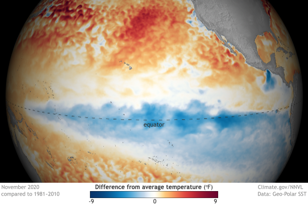
La Niña—the cool phase of the El Niño-Southern Oscillation climate pattern—strengthened in the tropical Pacific in October 2020. Forecasters estimate a 95% chance La Niña will last through Northern Hemisphere winter. La Niña winters tend to favor warm and dry conditions in the southern tier of the U.S. and snowier-than-average conditions across much of the northern U.S.
(image at left) Cooler-than-average surface waters in the central and eastern tropical Pacific in November 2020 are one sign of La Niña.

El Niño and La Niña are the warm and cool phases of a recurring climate pattern across the tropical Pacific—the El Niño-Southern Oscillation, or “ENSO” for short.
The pattern can shift back and forth irregularly every two to seven years, and each phase triggers predictable disruptions of temperature, precipitation, and winds.
These changes disrupt the large-scale air movements in the tropics, triggering a cascade of global side effects.
More about El Niño
What is El Niño in a nutshell?
Understanding El Niño (video)
FAQs
ENSO alert system criteria
ENSO essentials
Educational Resources on ENSO

El Niño is anchored in the tropical Pacific, but it affects seasonal climate "downstream" in the United States. In the summer, El Niño's primary influence on U.S. climate is on the hurricane season in both the eastern Pacific and the Atlantic.
Typical ENSO impacts
Winter temperature and precipitation
Hurricane season impacts
Current outlooks
6-10 day outlook
8-14 day outlook
1-month outlook
3-month outlook

El Niño and La Niña have their strongest influence on global climate during the Northern Hemisphere winter. During La Niña winters, the southern tier of the United States is often drier than normal. Northern Australia, Indonesia, and the Philippines are often wetter than normal.
More information
ENSO's cascade of global impacts
The Walker Circulation
More maps of global impacts of La Niña and El Niño

December 2020 La Niña update: walking in a La Niña winter wonderland
December 10, 2020
La Niña's here through winter, but chances for ENSO to transition to neutral by spring are rising. Read more
(left) A deep pool of cooler-than-average water occupied the eastern half of the tropical Pacific Ocean in early December 2020. This pool of cool water in the upper 700 meters of the ocean can sustain La Niña in coming months. NOAA Climate.gov image, based on Climate Prediction Center Data.
Quarterly outlooks by region
Global Resources
ENSO @ the Australian Bureau of Meteorology
ENSO @ the World Meteorological Organization
ENSO @ the International Research Institute for Climate & Society
ENSO @ Instituto del Mar del Perú (IMARPE) (Spanish)
ENSO @ the Centro Internacional para la Investigación del Fenómeno de El Niño (CIIFEN) (Spanish)
Videos

![]()