
Earthquake Hazards
Earthquakes
Find recent or historic earthquakes, lists, information on selected significant earthquakes, earthquake resources by state, or find webservices.
Latest Earthquakes

Latest earthquakes map and list for U.S. and worldwide. Tap/click on "gear icon" for options and settings.
Interactive MapDid You Feel It?
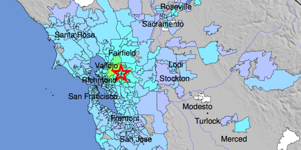
Did You Feel It? (DYFI) collects information from people who felt an earthquake and creates maps that show what people experienced and the extent of damage. If you felt an earthquake, let us know.
Tell Us!
Peter Haeussler prepares to measure the offset of a crevasse on the Canwell Glacier, Alaska, USA. Photo by Peter Haeussler, USGS, November 9, 2002. (Public domain.)
Latest Earthquakes
Latest earthquakes map and list. Tap/click on "gear icon" for options and settings.
Earthquake Lists, Maps and Statistics
Largest earthquakes, significant events, lists and maps by magnitude, by year, or by location.
Special Earthquakes, Earthquake Sequences, and Fault Zones
Compilations of information about significant earthquakes, swarms or sequences, and fault zones of interest.
Search Earthquake Catalog
View historic seismicity, find past earthquakes that meet your criteria. Various output formats, and links to earthquake details.
Real-time Notifications, Feeds, and Web Services
Get real-time earthquake notifications sent to you on your phone or by email, or subscribe to real-time feeds. Use real-time web services for your own applications.
Information by Region
Information by state, and world seismicity maps. Links to earthquake-related information for each state.
Errata for Latest Earthquakes
Mistakes happen. Here are the explanations.