Oak Ridge National Laboratory (ORNL) DAAC

Oak Ridge National Laboratory (ORNL) DAAC

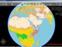
Map of on-road carbon dioxide emissions for the conterminous United States for the year 2017 available from the Database of Road Transportation Emissions (DARTE). Source: https://doi.org/10.3334/ORNLDAAC/1735
ORNL DAAC specializes on data and information relevant to terrestrial biogeochemistry, ecology, and environmental processes, which are critical to understanding the dynamics of Earth's biological, geological, and chemical components.
Contact Information
Bruce Wilson, PhD, DAAC Manager
Tammy Beaty, Deputy DAAC Manager and User Services POC
Chris Lindsley, Chief Architect and Security POC
Yaxing Wei, PhD, Lead Scientist
Daine Wright, Systems Engineer
PO Box 2008
Oak Ridge, TN 37831


Biogeochemical Dynamics Data
ORNL DAAC archives data and model products that were generated with funding from the NASA Terrestrial Ecology program and other programs within the NASA Carbon Cycle and Ecosystems focus area. Datasets are organized by both the name of the associated NASA project and by science themes in biogeochemical and ecological research.
Data Tools and Services: Spatial Data Access Tool, Thematic Real-time Environmental Distributed Data Services (THREDDS), Daymet Single Pixel Extraction Tool, and land product subsets.
Links
-

-
-
-

NetCDF Why and How: Creating Publication Quality NetCDF Datasets
During this webinar we will introduce step-by-step methods, software, and tools that you can use to create, visualize, and standardize netCDF files before submitting your data to an archive.
-
Introduction to Geospatial Analysis in R
During this webinar we will provide an overview of common geospatial operations in R including how to import data files into R, overlay layers, reduce spatial extent, select and reclassify values, and make a map.
-
Accessing ABoVE Airborne Data using Earthdata Search
The purpose of this tutorial is to demonstrate how to use Earthdata Search to access and download data from the ABoVE airborne campaign for a spatial region of interest. Earthdata Search is a NASA Earth Observing System Data and Information System client for discovering, searching, visualizing, and retrieving Earth science data.
-
NetCD What? An Ecologist’s Guide to Working with Daymet and other NetCDF formatted Data
During this webinar, we will provide an overview of the netCDF data format and show participants how to open, read, write and plot data that is in the netCDF format using R and Python with Jupyter Notebook. The use case will focus on the Daymet meteorological variables data product.
Page Last Updated: Mar 27, 2020 at 9:10 AM EDT
