Please note: Due to browser FTP deprecation, users will no longer be able to access NCEI data via browser FTP clients. Users may access data via NCEI Web Accessible Folders and/or FTP client supported applications. We apologize for any inconvenience. See this document as reference.
Global Data Assimilation System (GDAS)

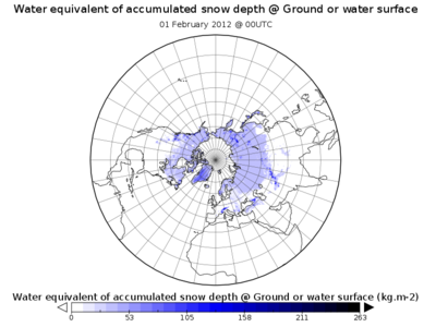
A plot of GDAS output showing the amount of water in snow covering the ground on February 1st, 2012 at 00UTC. This image was produced by visualizing GDAS output data with NASA’s Panoply visualization tool.
More...
Product Types
| Product | Grid/Scale | Period of Record | Model Cycle | Output Timestep | Data Access Links |
|---|---|---|---|---|---|
| GDAS Snow, Ice, SST, Satellite, Ship, Aircraft (GRIB and BUFR) | 1° by 1°, 0.5° by 0.5°, 0.25° by 0.25° | 05Jun2020–Present (approx. one year to present online) | 4/day: 00, 06, 12, 18UTC | Anl, +00, +03, +06, +09 hours | HTTPS |
| GDAS Snow, Ice, SST, Satellite, Ship, Aircraft (GRIB and BUFR), Historical | 1° by 1°, 0.5° by 0.5°, 0.25° by 0.25° | 21Apr2019–11May2020 | 4/day: 00, 06, 12, 18UTC | Anl, +00, +03, +06, +09 hours | HTTPS |
| GDAS - Daily Tar Files | 1° by 1° | 01Jan2001–21Feb2012 | 4/day: 00, 06, 12, 18UTC | Anl, +00, +03, +06, +09 hours | HAS |
| GDAS - Hourly Tar Files | 1° by 1°, 0.5° by 0.5°, 0.25° by 0.25° | 13Feb2012–Present | 4/day: 00, 06, 12, 18UTC | 4/day: 00, 06, 12, 18UTC | HAS |
| GDAS - Daily BUFR Files | 1° by 1°, 0.5° by 0.5°, 0.25° by 0.25° | 13Feb2012–Present | 4/day: 00, 06, 12, 18UTC | Anl, +00, +03, +06, +09 hours | HAS |
Data Usage Notes
None
Publication References
None
Miscellaneous Documentation
NCEP: GFS/GDAS Changes Since 1991
NCEP Environmental Modeling Center (EMC) Mesoscale Modeling Branch Publication Listing
Links


