
Hunters Hole
Gadsden, AZ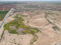


- DESCRIPTION
- LOCATION
- SPECIES USE
- ACTIVITIES
- MULTIMEDIA
Hunters Hole Conservation Area is located within the historic floodplain of the Colorado River, in Arizona, approximately three miles north of the U.S./Mexico Southerly International Boundary. The site was initially created by flooding in the 1950s, which formed a series of interconnected ponds with adjacent marsh and cottonwood-willow stands. Water levels were maintained by groundwater, irrigation drain flows, and a connecting channel to the main river channel.
Over time, the habitat degraded due to reduced mainstream flows, sediment buildup which isolated the area from the main stem of the river, fire, and groundwater pumping. In 2001, local officials from state, tribal, and Federal agencies joined together in an effort to restore the area while increasing public safety and border security.
Completed in 2013, the LCR MSCP established the 44 acre site as a conservation area and provided funding for long-term operation and maintenance. Restoration activities included selective clearing of invasive reeds and saltcedar while leaving existing native trees, installation of infrastructure to allow for managed flooding, and planting with native cottonwood-willow, marsh plants, salt grass, and honey mesquite, as well as installation of a groundwater well and automated pump to provide a reliable fresh water supply.
A fact sheet for this conservation area can be found here.
Updated January 7, 2020
Hunters Hole Conservation Area is located within the State of Arizona, in Reach 7 of the LCR MSCP planning area, at River Mile 2.5. The site is located on Reclamation withdrawn lands. The total project footprint is 44 acres.
For specific information on the Conservation Area, please contact Terry Murphy, Restoration Group Manager, at (702) 293-8140 or via email at tmurphy@usbr.gov.
Below is a map of the conservation area boundaries.

Each Conservation Area targets certain LCR MSCP covered and evaluation species habitats. Below, on the left, is a list of the LCR MSCP species in which habitat will be targeted for creation for this particular conservation area. To the right is a list of LCR MSCP species that, through monitoring, have been found utilizing the conservation area.
| Targeted LCR MSCP Species | LCR MSCP Species Utilizing Site |
| Riparian Obligates | Riparian Obligates |
| Arizona Bell's Vireo | Arizona Bell's Vireo (transient) |
| Gila Woodpecker | |
| Gilded Flicker | |
| Sonoran Yellow Warbler | Sonoran Yellow Warbler (breeding) |
| Southwestern Willow Flycatcher | |
| Summer Tanager | |
| Vermilion Flycatcher | |
| Yellow-Billed Cuckoo | Yellow-Billed Cuckoo (possible breeding) |
| Bats, Small Mammals, and Insects | Bats, Small Mammals, and Insects |
| Yuma Hispid Cotton Rat | Yuma Hispid Cotton Rat (resident) |
| California Leaf-Nosed Bat (foraging) | |
| Western Red Bat (foraging) | |
| Western Yellow Bat | Western Yellow Bat (foraging) |
| MacNeill's Sootywing Skipper |
The Yuma Crossing National Heritage Area, as the lead agency for the Hunters Hole restoration and utilizing funding provided by the Arizona Water Protection Fund, cleared, leveled, and installed irrigation infrastructure in the fall of 2011. Riparian planting was completed in the spring of 2012. Routine maintenance activities consist of invasive plant species control, road maintenance, and irrigation scheduling. The LCR MSCP will maintain ownership of the property and manage the property for LCR MSCP covered species throughout the life of the program. Automation of the irrigation system is being implemented to reduce on-site labor and lower the annual operating cost of the project.
Bird Monitoring
Surveys for covered birds are conducted annually. Marsh bird surveys were conducted until 2014 when the marsh transitioned to riprarian woodland. During the late spring and summer, presence surveys are conducted for riparian birds to document use of the conservation area for nesting, foraging, and migration. Riparian birds monitored include the listed southwestern willow flycatcher and yellow-billed cuckoo, and the following covered species: Arizona Bell’s vireo, Gila woodpecker, gilded flicker, Sonoran yellow warbler, summer tanager and vermilion flycatcher.
Mammal Monitoring
Small mammal live trapping is conducted annually to monitor presence of Yuma hispid cotton rats and desert pocket mice at the conservation area. Bat presence is monitored annually from June through August by remotely recording echolocation calls using a long-term Anabat™ station as part of systemwide monitoring.
Acreage Map
This map shows the acreage for this area. You can click on the map for a larger view.

This gallery includes photos of this conservation area. If you require larger photos, please contact our webmaster Michelle Reilly at mreilly@usbr.gov.


