-
1787
Exclusive Power

Article I, Section 8 of the Constitution grants Congress "To exercise exclusive Legislation in all Cases whatsoever" over the federal District.
-
1790
The Residence Act
The Residence Act established the District of Columbia at the confluence of the Potomac and Anacostia Rivers and declared it the seat of the United States Government. George Washington selected Pierre L'Enfant to plan the capital city.
-
1791
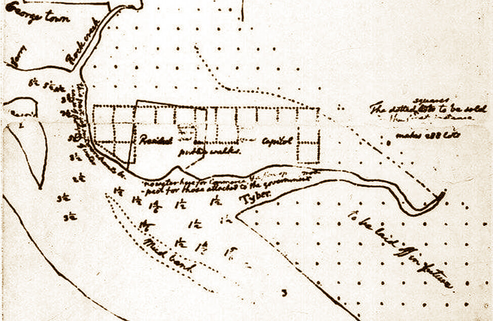
L'Enfant Plan

In 1791 Pierre L'Enfant set out to create a "magnificent city, worthy of the nation, free of its colonial origins, and bold in its assertion of a new identity." His design proposed an orthogonal, gridded street network with diagonal avenues visually and physically connecting key civic buildings and spaces.
-
1792
Ellicott Plan

After L'Enfant's resignation, city surveyor Andrew Ellicott produced the "official city plan" for Washington with streets and lots. He straightened or eliminated some radial avenues, and numbered the blocks to facilitate the sale of lots.
-
1814
The Burning of Washington

In August 1814, the British burned various govenrment facilities, including the White House and U.S. Capitol, as part of a brief occupation of Washington, DC during the war of 1812. James Hoban, the original architect of the White House, oversaw its rebuilding, while Benjamin Latrobe provided major repairs to the damaged U.S. Capitol. The Marine Corps Commandant's Quarters at 8th and I Streets, SE was one of the few buildings that was not damaged when the British burned Washington, DC and it remains the one federal building to be in continuous use since that time.
-
1836
Obstructed Views

Construction of the U.S. Treasury Building adjacent to the White House blocked views along Pennsylvania Avenue between the "President's House" and the "People's House."
-
1846
Retrocession
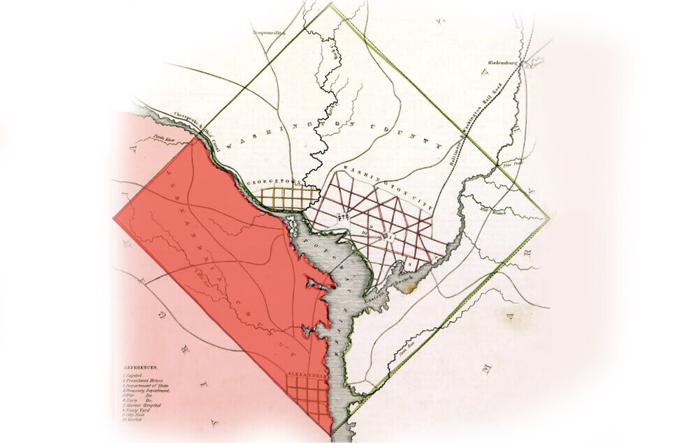
The return to the state of Virginia of the land it ceded to the federal government to create Washington, DC, the national capital. The area, formed in 1790 under the name of "District of Columbia," initially consisted of 100 square miles ceded by the states of Maryland and Virginia in accordance with the Residence Act.
-
1848
National Mall Development

In 1848, construction began on the Washington Monument. However, partially due to a lack of funds, it was not completed until 1884, following a period of no construction that lasted from 1856-1876. Construction began on the Smithsonian Castle in 1849.
-
1861
Civil War

As a wartime capital, Washington's population grew dramatically during and after the Civil War, from 75,000 to 130,000. It was a place of refuge for many African-Americans, particularly following President Lincoln's 1863 Emancipation Proclamation. During the war the federal government constructed a 37-mile circle of fortifications, including 68 forts and 93 detached batteries, for the capital's defense. The McMillan Plan later proposed turning these defenses into a system of public parks that are known today as the Fort Circle Parks. NCPC acquired much of the land connecting the major parks.
-
1871
Post-Civil War

After the Civil War, Washington's infrastructure was in sad shape, and did not keep up with growth. President Grant appointed Alexander Robey "Boss" Shepherd as governor to oversee improvements to the Territory of Columbia (then, the combined cities of Washington and Georgetown and the County of Washington). During his tenure, hundreds of miles of sewers, water mains, gas lines, sidewalks and paved roads were completed, the Washington Canal covered, and street trees planted. Controversy led to the creation of a three-commissioner government, and the U.S. Army Corps of Engineers assumed responsibility for infrastructure.
-
1893
Permanent System of Highways
Congressionally legislated, the Permanent System of Highways was intended to create an orderly framework for development beyond the L'Enfant City as Washington continued to grow. Frederick Law Olmstead, Sr. contributed to this plan.
-
1894
Protest Marches

The tradition of protest marches on Washington and the National Mall began with Coxey's Army. They have since grown in number and size. Protests and demonstrations for causes such as women's suffrage, voting rights, war protests, and civil rights continue.
-
1898
Potomac River Dredging

The U.S. Congress authorized dredging of the Potomac River and reclamation of the Potomac Flats. Potomac Park was constructed on reclaimed land.
-
1902
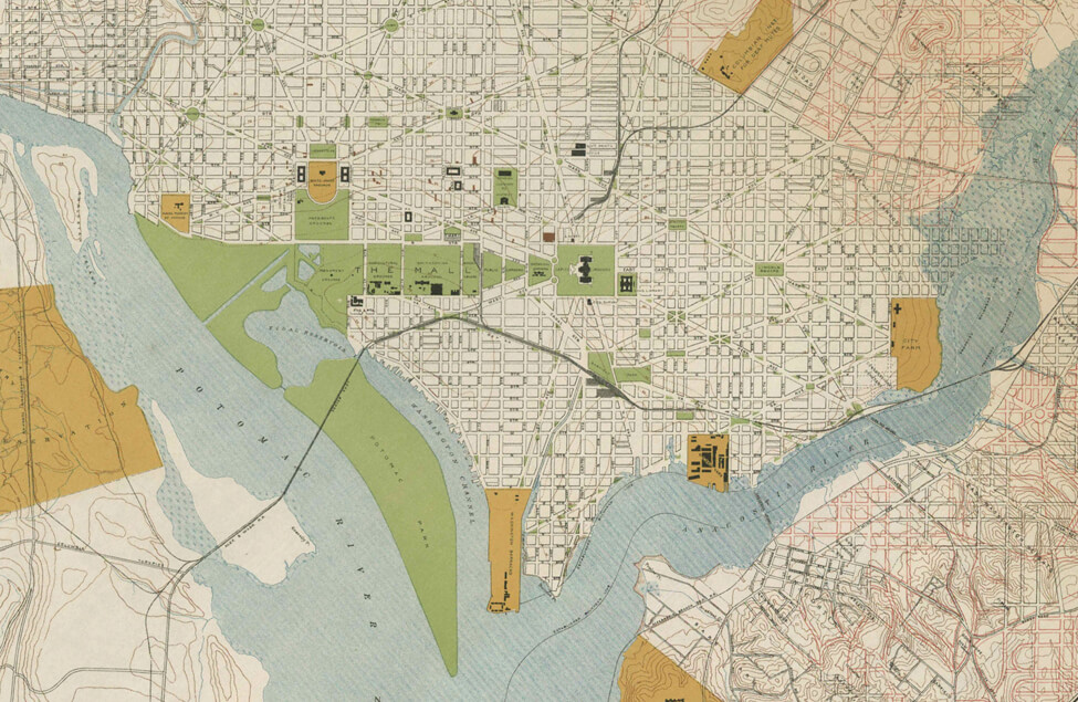
McMillan Plan

Senator James McMillan established the Senate Park Commission to restore the grandeur of L'Enfant's vision. The McMillan Plan, released in 1902, made a distinctive imprint on the city's architecture and public spaces, particularly in the National Mall's open greenway, the monumental core of federal buildings, and the comprehensive public park system.
-
1910
Height of Buildings Act

Passed by Congress, the act was key in establishing the national capital's horizontal character by setting maximum building heights generally controlled by street widths. The height limit on residential streets is 90 feet. Height limits on commercial streets is the width of the adjacent street plus 20 feet, with a general maximum height limit of 130 feet (except for 160 feet along portions of Pennsylvania Avenue).
Learn More -
1910
U.S. Commission of Fine Arts

Congress created the U.S. Commission of Fine Arts to function as the guardian of the McMillan Plan. The Commission remains today as a sister organization to NCPC, and it reviews proposed designs for new or renovated federal buildings, memorials, coins, medals, and some privately owned land in Washington (under the Shipstead-Lucy and Old Georgetown Acts) with a focus on design and aesthetics.
-
1914
World War I

Wars continued to shape the city's built environment. Following the United States' entry into the war in 1917, construction of the Main Navy and Munitions Building in 1918 on the National Mall to provide temporary quarters for the military. The buildings remained until 1970.
-
1924
National Capital Park Commission

Federal legislation created the National Capital Park Commission to develop a comprehensive plan for the park, parkway, and playground systems of Washington.
-
1926
National Capital Park & Planning Commission

The organization, renamed the National Capital Park and Planning Commission (NCPPC), had its duties expanded to include consideration of all elements of city and regional planning, such as land use, major thoroughfares, systems of parks, parkways, and recreation, mass transportation, and community facilities. NCPPC had comprehensive planning authority for "proper elements of city and regional planning" while coordinating plans of federal district departments. This included overseeing housing reform, responding to traffic issues, and planning for commercial and industrial development.
-
1926
Federal Triangle
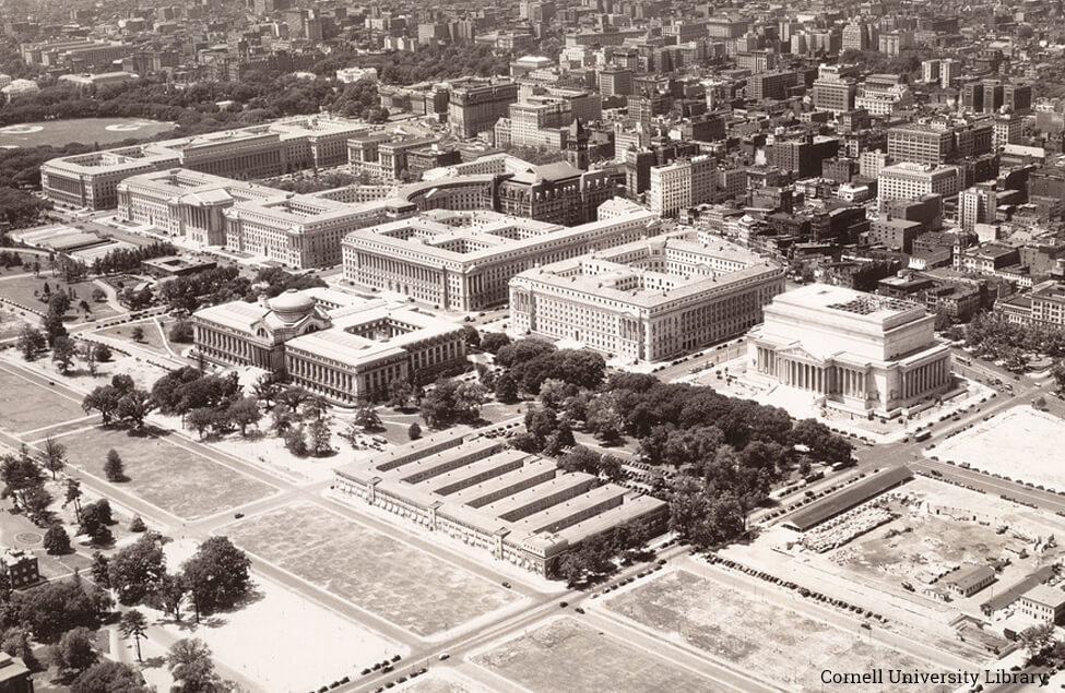
The 1926 Public Buildings Act authorized construction of the 70-acre complex of buildings known today as the Federal Triangle. Construction of 10 buildings, including the U.S. Department of Commerce, IRS, U.S. Department of Justice, and the National Archives, continued through 1938.
-
1927
Regional Planning

Creation of planning bodies at the county and state level, including the Maryland-National Capital Park and Planning Commission, established by the state in 1927 with authority in both Montgomery and Prince George's Counties. These federal and state agencies worked together on planning initiatives throughout the following decades.
-
1928
Potomac River Parks

The National Capital Park and Planning Commission issues the Plan for Potomac River Parks, covering the area from Mount Vernon to Great Falls.
-
1930
Capper-Cramton Act

The Capper-Cramton Act authorized NCPPC to acquire land for a regional park and parkway system, including coordinated acquisition of stream valley parks with Maryland and Virginia planning authorities. Funds from this act acquired land for the George Washington Memorial Parkway, an extension of Rock Creek Park into Maryland, and an extension of the Anacostia Park System.
Learn More -
1930s
Great Depression

New Deal federal programs sought to address unemployment and poverty, and the federal workforce in Washington grew. The ideas of Rexford Tugwell, an advisor to President Roosevelt, led to the development of Greenbelt, Maryland.
-
1933
Mall Development Plan

Congress funded the plan, initially authorized in 1929, which instructed the modernization plan of the National Mall in accordance with the L'Enfant and McMillan Plans and modifications recommended by the NCPPC. Resulted in the National Mall as we know it today.
-
1938
National Airport

President Roosevelt decides to construct a new federal airport at Gravelly Point, between the 14th Street Bridge and Alexandria, Virginia. The airport opened for passenger service on June 16, 1941.
-
1939
World War II

Construction of the Pentagon, the U.S. Department of Defense headquarters, began in 1941 (in September, prior to the U.S. entering the war in December) and lasted until 1943. At 6.5 million square feet, it is one of world's largest office buildings. The wartime economy brought thousands to Washington.
-
1945
District of Columbia Redevelopment Act
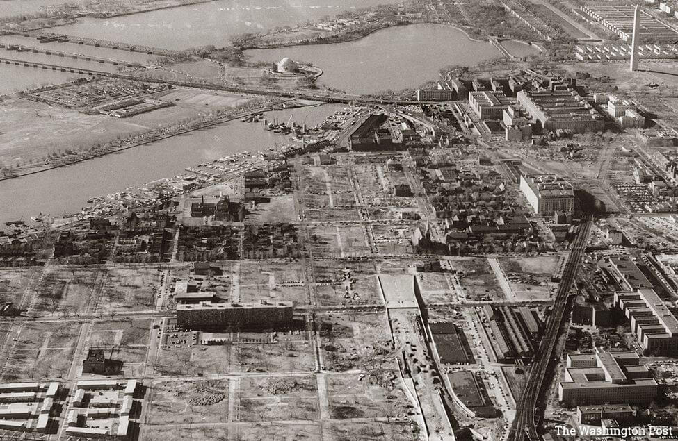
This act began the process of urban renewal in the city. Renewal plans ultimately cleared 400 acres in the city's southwest quadrant that resulted in the development of new apartment buildings and federal offices, but at the cost of the forced removal of 23,500 people and the destruction of numerous historic buildings.
-
1950
Population Peak

Washington's population peaked at just over 800,000. Government jobs and the Great Migration from the South attracted African-Americans, and Washington became a majority black city from the 1950's through 2011.
-
1950
First Comprehensive Plan

NCPPC produced the Comprehensive Plan, primarily covering the District of Columbia but also addressing regional issues. The National Capital Regional Planning Council, a federal agency that operated between 1952 and 1966, issued a "Regional Development Guide" in 1966. NCPC issued drafts of new Comprehensive Plans in 1965 and 1967.
Learn More -
1950
Highways

Freeway planning followed the increasing use of private cars, and the Eisenhower Interstate Highway System brought funding and additional impetus. The Capital Beltway made its first formal appearance on regional planning documents when it appeared on maps and in a one-sentence reference in the Comprehensive Plan.
-
1952
National Capital Planning Commission

The National Capital Planning Act renamed the NCPPC as the National Capital Planning Commission and clarified its role as a federal agency. The Act established NCPC as the central planning agency for the federal government in the National Capital Region. NCPC and the District of Columbia jointly shared responsibility for creation of the Comprehensive Plan for the National Capital.
Learn More -
1953
Urban Renewal

Redevelopment Land Agency invitation to developers to submit plans for Southwest Washington began the process of land assembly, building demolition, site preparation, and land disposal that resulted in the displacement of thousands of Washingtonians and the destruction of numerous historic structures.
-
1950s
Suburban Campus Development

New federal campuses were located in suburban Maryland and Virginia, consistent with private sector campuses, the new highway systems, and Cold War concerns about nuclear attack that promoted dispersal of federal facilities into the region. Coincided with a post-war suburban residential boom, made possible by the automobile.
-
1955
Mass Transit

One of the important early steps in the future Metro system's development was the congressionally directed Mass Transportation Study conducted by NCPC. Begun in 1955, the resulting A Transportation Plan for the National Capital Region recommended, among other things, the creation of a 33-mile rapid transit system.
-
1961
Wedges and Corridors

NCPC and the National Capital Regional Planning Council produced the influential Year 2000 Plan, proposing a model for long-term regional growth. M-NCPPC then incorporated and expanded on this recommended model in its own comprehensive plan, titled "On Wedges and Corridors." Central Washington is the region's focus and developed corridors separated by wedges of open countryside extend out, linking major development centers.
-
1964
Capital Beltway

Completion of the I-495 Capital Beltway when its final Maryland segment opened to traffic on August 17, 1964. The Southeast Freeway, including the section planned as I-295 to Pennsylvania Avenue, was built in the late 1960s. Plans for other Interstates in Washington were canceled in 1977 after much opposition
-
1968
Year of Change

The assassination of Dr. Martin Luther King, Jr. led to widespread rioting in Washington and major damage to the U Street, NW and H Street, NE corridors.
-
1970
Master Plans

In preparation for the nation's Bicentennial, on behalf of the National Park Service Skidmore, Owings and Merrill prepared master plans for the National Mall. This resulted in the development of Constitution Gardens, locations for new museums, and plans for Pennsylvania Avenue.
-
1972
International Chancery Center

Congress passed the International Center Act, leading to development of the Center on a 47-acre site in Northwest Washington that formerly housed the National Bureau of Standards. The U.S. Department of State developed it into a campus for foreign embassies that formally opened in 1972. The People's Republic of China embassy, completed in 2008, occupied the last available site.
-
1972
Pennsylvania Avenue Development Corporation

Established in 1972 with a goal to "develop Pennsylvania Avenue in keeping with its historical and ceremonial role," the corporation oversaw the redevelopment of the avenue into a grand urban boulevard. Congress dissolved the Pennsylvania Avenue Development Corporation in 1996 and delegated responsibility for the avenue to NCPC, the General Services Administration, and the National Park Service.
-
1973
Home Rule

Pressure had built for home rule in the District of Columbia, including reconsideration of the appropriateness of NCPC's role as Washington's local planning agency. The federal Home Rule Act of 1973 designated the District of Columbia's elected mayor as the planner for the District government, a power exercised through the DC Office of Planning. NCPC's role was re-defined to focus primarily on federal property in Washington and the region.
-
1976
Metro Opens

During the 1950s, NCPPC and NCPC studies demonstrated the need for a regional mass transit system, leading to the federal authorization of the Washington Metropolitan Area Transit Authority in 1965. Construction on the Metrorail system began in 1969, and in 1976, the first Red Line segment opened to the public from Farragut North to Rhode Island Avenue.
-
1977
Worthy of the Nation

Commissioned by NCPC as part of its Bicentennial program and written by Frederick Gutheim, this book was the first comprehensive look at almost 200 years of planning in the nation's capital. In 2006 NCPC guided and edited a second edition that described the transformation of Washington into one of the country's most vibrant cities.
-
1970s
Modernist Federal Architecture

The late 1960s/early 1970s saw construction of several major federal offices downtown, including buildings for the U.S. Department of Housing and Urban Development (1968), Federal Aviation Administration (1963), FBI (1974), Hirshhorn Museum (1974), U.S. Department of Labor (1975), and the Consumer Financial Protection Bureau (1976).
-
1980s
Comprehensive Plan

A new comprehensive planning effort began in the 1970s, leading to the publication of the Comprehensive Plan for the National Capital during the mid-1980s. This plan, a joint effort of NCPC and the District of Columbia government, contained Federal Elements, addressing federal concerns throughout the region, and District of Columbia Elements, addressing matters of local concern. The Federal Elements also work in conjunction with the comprehensive plans adopted by the various counties and cities of the region. This shared responsibility for the Comprehensive Plan remains the model for planning in the National Capital Region.
Learn More -
1982
Vietnam Veteran's Memorial

The memorial design, initially controversial, proved to have a lasting influence on commemorative form. Other war memorials followed on the west side of the Mall, including the Korean War Veterans Memorial (1995) and the World War II Memorial (2004). NCPC reviewed all these projects.
-
1986
Commemorative Works Act

Passed by Congress, the act specifies the requirements for the development, approval, and location of new memorials and monuments in the District of Columbia and its environs.
Learn More -
1997
Extending the Legacy

In the 1990's, realizing that great cities can't rest on their laurels and concerned that new memorials and museums were crowding the National Mall, NCPC began planning for the next 50-100 years. Building upon the L'Enfant and McMillan Plans, this groundbreaking effort proposed a redefinition of Washington's monumental core by shifting the perceived center of the city to the U.S. Capitol and directing federal development outward into all city quadrants. It also focused on integrating the Potomac and Anacostia Rivers into the city's public life and protecting the National Mall and the adjacent historic landscape from future building.
Learn More -
2000
Anacostia Waterfront Initiative

Initiated in 2000, the 30-year, $10 billion Anacostia Waterfront Initiative is transforming the shores of the Anacostia River into a world-class waterfront. Led by the District of Columbia government and embraced by 19 regional and federal agency partners, the study area straddles the Anacostia River and stretches from the Tidal Basin to the city's northeast border. AWI promises a clean river environment, new parks and other recreational facilities, more job-creating commercial centers, revitalized residential neighborhoods, and multi-modal transportation options. NCPC is an active participant, and the agency's Legacy Plan and 1999 Washington Waterfronts report sparked interest in a connected, renewed waterfront.
-
2001
Memorials and Museums Master Plan

Advancing the vision for Washington's monumental core expressed in the Legacy Plan, NCPC, the U.S. Commission of Fine Arts, and the National Capital Memorial Advisory Commission identified 100 potential sites for future memorials and museums and provided general guidelines, siting criteria, and implementation strategies. The plan proposed creation of a ‘reserve' or no-build zone, on the Mall, a concept Congress made into law in 2003.
Learn More -
2002
Security in the Nation's Capital

In response to the Oklahoma City bombing and 9-11, the nation's capital saw the installation of numerous ad-hoc, temporary, and ugly security measures. To address these and show how to combine appropriate security with good urban design, NCPC prepared the National Capital Urban Design and Security Plan. The plan, amended in 2004 to include site-specific solutions and improved guidance to sub-mitting agencies, provided guidance for the design of contextually sensitive physical security features in the city's monumental core.
Learn More -
2003
The Reserve

Congress amended the Commemorative Works Act to establish a Reserve, or "no-build" zone (highlighted in red), on the National Mall. In response to this expanded reserve, in 2006 NCPC formally removed four sites from future consideration for new commemorative works.
Learn More -
2004
Comprehensive Plan Update

This Federal Elements update was linked by three guiding principles: (1) accommodating federal and national capital activities, while accounting for the changing impact of the federal government in the region; (2) reinforcing smarter, more coordinated growth and sustainable development principles; and (3) supporting coordination with local and regional governments in the National Capital Region to promote mutual planning and development objectives.
Learn More -
2005
BRAC

The Base Realignment and Closure action significantly affected the Washington region. U.S. Department of Defense facilities moved out of leased space, primarily in northern Virginia. The Walter Reed Army Medical Center in Washington closed and its functions relocated to Maryland and Virginia. Several installations, such as Fort Belvoir, received significant growth, new facilities such as the ICC-B in Bethesda, were built, while others were closed.
-
2005
South Capitol Street

One of the prime axials leading to the U.S Capitol, for many years it was a bleak stretch of thoroughfare strewn with empty lots and abandoned businesses. NCPC's vision to transform it began with the Legacy Plan, and continued with 2003's South Capitol Street Urban Design Study. In 2005, the South Capitol Street Task Force released recommendations to transform the corridor into a grand urban boulevard and waterfront gateway with spectacular views to and from the U.S. Capitol, green space, mixed-use development, new commemorative works, and a beautiful new Frederick Douglass Memorial Bridge.
-
2009
St. Elizabeths

NCPC approved the master plan for the consolidation of the U.S. Department of Homeland Security Headquarters at the historic St. Elizabeths campus in southeast Washington. Anticipated to accommodate 4.5 million square feet of space, the east and west campuses are still under construction.
-
2009
Monumental Core Framework Plan

Diving deeper into the Legacy Plan's goal of infusing the civic quality of the National Mall with the vitality of the city, this NCPC and U.S. Commission of Fine Arts led effort targeted four predominantly federal precincts around the National Mall. The goal–provide guidance for the creation of vibrant and accessible mixed-use destinations to work, commemorate, visit, and live that are linked with the National Mall, the waterfront, and the city's urban design.
Learn More -
2009
CapitalSpace

Washington, DC is a city of parks, with more green space per person than any other American city of its size. However, the wide variety of parks, quality, and capacity, along with shared jurisdictional responsibility, resulted in their not meeting the needs of residents, workers, and visitors. CapitalSpace, the first comprehensive planning analysis of Washington's parks and open space in almost 40 years, provided a vision for a beautiful, high quality, and unified park system through six big ideas. The plan was a joint initiative of NCPC, the National Park Service, and the District of Columbia.
Learn More -
2012
Height Master Plan

Following a request by the Chairman of the House Committee on Oversight and Government Reform, United States House of Representatives, NCPC and the District of Columbia undertook the Height Master Plan to examine the current relevance of the Height of Buildings Act and whether changes could benefit the city. Following extensive outreach, the study resulted in minor amendments to the Height Act that were consistent with NCPC's recommendations. These included allowing human occupancy in rooftop penthouse structures and maintaining the current 1:1 setback. President Obama signed a bill on May 16, 2014 amending the Height Act.
Learn More -
2013
SW Ecodistrict Initiative

The first component of the Framework Plan addressed was the Southwest Rectangle, a disconnected 110-acre predominantly federal precinct. The initiative proposed to not only improve the connection between the National Mall and the southwest waterfront, but to also yield greater environmental and economic benefits by using district-scale sustainable practices to integrate land use, transportation, and environmental planning with high performance buildings, landscapes, and infrastructure.
Learn More -
2016
Comprehensive Plan Update

The most recent comprehensive plan update included a new Federal Urban Design Element that incorporated NCPC's extensive work on perimeter security, building heights, and viewsheds. Policies reflected increased interest in an efficient, sustainable federal workplace, and reflected the impact of technology and changing work practices.
Learn More
Washington, DC is a planned city, intended to serve as the nation's capital. Throughout the city's history, major plans and significant local and national events have shaped its design and growth. Timelines highlighted in blue indicate NCPC specific historical significance.
The National Capital Planning Commission is the federal government's planning agency for the National Capital Region.
The 12-member Commission meets monthly to adopt, approve, or provide advice on plans and projects that impact the nation's capital and surrounding areas.
401 9th Street, NW
Suite 500N
Washington DC 20004
Phone: (202) 482-7200
Fax: (202) 482-7272
Email: info@ncpc.gov
Suite 500N
Washington DC 20004
Phone: (202) 482-7200
Fax: (202) 482-7272
Email: info@ncpc.gov