Digital Coast Connections


Decemeber 2020
Lidar Data, Virtual Meetings, and More
Also Noted
- Tech Topics: Get Lots of Data from Multiple Links in a Snap
- Stories From Your Peers: Using Lidar to Determine Bluff Recession Rates
- Tips from the Digital Coast Academy: When Planning an Effective Virtual Meeting, It’s All about the Timing
- Fast Fact: Coral Reefs

November 2020
Green Infrastructure, Habitat Conservation, and More
Also Noted
- Tech Topics: Geospatial Data in the Wrong Place?
- Stories From Your Peers: Balancing Habitat Conservation with Public Beach Access
- Tips from the Digital Coast Academy: Green Infrastructure Success – You’ve Got This
- Fast Fact: Land Cover Change

October 2020
Water Quality, Meeting Facilitation, and More
Also Noted
- Tech Topics: Using Land Cover Data as a Water Quality Indicator
- Stories From Your Peers: Identifying Conservation Priorities for Sea Level Rise Adaptation
- Tips from the Digital Coast Academy: Lead Your Next Meeting with Confidence
- Fast Fact: Wetland Benefits

September 2020
Writing SMART Objectives, Marsh Studies, and More
Also Noted
- Tech Topics: Next-Generation Satellite Data Furthers Coral Health Monitoring
- Stories from Your Peers: Crabs in the Marsh Study
- Tips from the Digital Coast Academy: The SMART Way to Set Project Objectives
- Fast Facts: Hurricane Costs

August 2020
Shoreline Protection, Risk Assessment, and More
Also Noted
- Tech Topics: To Create a Community Risk Assessment, Get Community Input
- Stories from Your Peers: Student Marsh Plantings Save Shoreline from Devastating Hurricane
- Tips from the Digital Coast Academy: Evaluate the Relationship between Community Goals and Policies
- Fast Facts: Climate Change Predictions

July 2020
Ecotourism, Participatory Mapping, and More
Also Noted
- Tech Topics: Map a Fuller Picture of Ocean Uses with Participatory GIS
- Stories from Your Peers: Documenting the Economic Impact of Ecotourism – It Makes a Difference
- Tips from the Digital Coast Academy: Facilitating Virtual Meetings? Help is on the Way!
- Fast Facts: Aquaculture

June 2020
Project Assessment, Community Resilience, and More
Also Noted
- Tech Topics: To Get Helpful Feedback, Do This
- Stories from Your Peers: Consider Sea Level Rise When Choosing New Utility Sites
- Tips from the Digital Coast Academy: Community Resilience Planning on a Budget
- Fast Facts: Weather Disasters and Costs

May 2020
Ocean Data, Risk Communication, and More
Also Noted
- Tech Topics: Ocean Data—Find It. View It. THEN Download It.
- Stories from Your Peers: Ecotours Bring Big Rewards
- Tips from the Digital Coast Academy: Risk Communication Questions—We Have Answers!
- Fast Facts: Hazard Mitigation Value

April 2020
Lidar, Green Infrastructure, Flood Maps, and More
Also Noted
- Tech Topics: Work Together to Make Lidar Accessible
- Stories from Your Peers: Training Inspires Community to Advance Green Infrastructure
- Tips from the Digital Coast Academy: Start the Flood Risk Conversation with a Map
- Fast Facts: NOAA 50th Anniversary

March 2020
Water Quality, Meeting Engagement, and More
Also Noted
- Tech Topics: Analyze Land Cover for Water Quality Insight
- Stories from Your Peers: Education Program Takes Root in Illinois Classrooms
- Tips from the Digital Coast Academy: Swap Perspectives to Engage Meeting Participants
- Fast Facts: Marine Debris

February 2020
Marsh Migration, Marine Debris, and More
Also Noted
- Tech Topics: Identify When and Where Marshes Will Migrate
- Stories from Your Peers: Don’t Trash Texas – Marine Debris Campaign
- Tips from the Digital Coast Academy: Determine the Value of Your Local Marine Economy – Then Protect It
- Fast Facts: Estuaries

January 2020
Coastal Flooding, Wild Rice, and More
Also Noted
- Tech Topics: Breaklines from the Data Access Viewer
- Stories from Your Peers: Combining Technical and Historical Data to Address Restoration Challenge
- Tips from the Digital Coast Academy: Having the “Waters are Rising” Conversation with Your Community
- Fast Facts: Natural Infrastructure

December 2019
Sea Level Rise, Marsh Migration, and More
Also Noted
- Tech Topics: Investigate Your Neighborhood with the Sea Level Rise Viewer
- Stories from Your Peers: Mitigating a Thorny Predatory Issue
- Tips from the Digital Coast Academy: Plan Ahead for Marsh Migration
- Fast Facts: High Tide Flooding

November 2019
County Snapshots, Mental Shortcuts, and More
Also Noted
- Tech Topics: Facts and Graphics to Help Drive Your Point Home
- Stories from Your Peers: Monitoring Increases Kayaker Safety at National Park
- Tips from the Digital Coast Academy: Recognize Mental Shortcuts and How They Influence Risk Preparedness
- Fast Facts: Land Cover Change

October 2019
Green Infrastructure, Tsunami Resilience, and More
Also Noted
- Tech Topics: Get Data for a Specific Shape, Like a Watershed
- Stories from Your Peers: Four Oregon Jurisdictions Bolster Tsunami Resilience
- Tips from the Digital Coast Academy: To Successfully Implement Green Infrastructure, Start with the Code
- News from Our Partners: Developing Urban Resilience
- Fast Facts: Wetland Benefits

September 2019
OceanReports Tool, Reducing Runoff, and Economic Valuation
Also Noted
- Tech Topics: Get the Big Picture on Your Ocean Neighborhood
- Stories from Your Peers: Volunteers Plant New Forest to Stem Grass Fire and Runoff Risks
- Tips from the Digital Coast Academy: No Price Tag Doesn’t Mean No Value
- Fast Facts: Tourism and Recreation

August 2019
Lidar Data Tips, Fisheries Management, and Stakeholder Engagement
Also Noted
- Tech Topics: Make Using Lidar Data in ArcGIS a Breeze
- Stories from Your Peers: Cold-Stun Alert Aids Fishery Managers and Seatrout Stocks
- Tips from the Digital Coast Academy: Effectively Involve Stakeholders in Land Use Planning to Build Resilience
- Fast Facts: Weather Disasters and Costs

July 2019
Map Tips and Adaptation Strategy
Also Noted
- Tech Topics: Map Benthic Habitats Efficiently and Effectively
- Stories from Your Peers: San Diego County Benefits from Adaptation Strategy
- Tips from the Digital Coast Academy: Make Your Maps Meaningful
- Fast Facts: Ocean Jobs

June 2019
TIFF File Help, Restoration Efforts in Puerto Rico, and more
Also Noted
- Tech Topics: Why Is the TIFF Black and White?
- Stories from Your Peers: NOAA Rehabs Puerto Rico Reefs, Trails, and Flood Maps
- Tips from the Digital Coast Academy: Communicate Risks Effectively
- Fast Facts: Economics and Demographics

May 2019
Customized Sea Level Rise Viewers and Participatory Mapping
Also Noted
- Tech Topics: Compare Past Shorelines to the Present – Digitize Them!
- Stories from Your Peers: Hawaii Tool and Groundbreaking Adaptation Policies
- Tips from the Digital Coast Academy: Get the Full Picture with Participatory Mapping
- Fast Facts: Hazard Mitigation Value

April 2019
Wetland Restoration and Stakeholder Engagement
Also Noted
- Tech Topics: The Best Ingredient for Creating the Best Product
- Stories from Your Peers: Program Promotes Wetland Restoration by Reducing Regulatory Burden
- Tips from the Digital Coast Academy: Put Focus Groups to Work
- Fast Facts: Coral Reefs

March 2019
Mapping Datums and Public Awareness Campaigns
Also Noted
- Tech Topics: Choose Your View Wisely
- Stories from Your Peers: Septic System Campaign Safeguards Waterways and Public Health
- Tips from the Digital Coast Academy: Think Outside the Box to Build Local Flood Awareness
- Fast Facts: Marine Debris

February 2019
Lidar and Stormwater Resources
Also Noted
- Tech Topics: Got Lidar?
- Stories from Your Peers: Expanding Coastal Opportunities for People with Disabilities
- Tips from the Digital Coast Academy: Flood Assessment Tool for Stormwater Systems
- Fast Facts: Natural Infrastructure

December 2018
Story Maps and Clean Water
Also Noted
- Tech Topics: Tell Your Story with Pictures, Text, and Maps
- Stories from Your Peers: Program Fosters Visibly Cleaner Boatyard and Marina Waters
- Tips from the Digital Coast Academy: Find a Project Champion
- Fast Facts: High Tide Flooding

November 2018
Aquaculture and Blue Carbon
Also Noted
- Tech Topics: The Nation’s Only Comprehensive Aquaculture Data Set
- Stories from Your Peers: Reserves Advance “Blue Carbon” Approach to Conserving Wetlands
- Tips from the Digital Coast Academy: Easy-to-Understand Maps at Your Fingertips – Learn How
- News from Our Partners: Learn from Experts at the Coastal Society’s Coastal Career Workshop
- Fast Facts: Ports

October 2018
Natural Infrastructure and More
Also Noted
- Tech Topics: Green Infrastructure Effectiveness
- Stories from Your Peers: Volunteers Clear 2,500 Pounds of Marine Debris in 24 Hours
- Tips from the Digital Coast Academy: Assess Vulnerabilities Efficiently and Effectively
- News from Our Partners: Developing Urban Resilience
- Fast Facts: Wetland Benefits

September 2018
All About Flood Risk
Also Noted
- Tech Topics: Calculating Coastal Flood Frequency
- Stories from Your Peers: Restoration Brings Six Times Return on Investment
- Tips from the Digital Coast Academy: Weigh Buyout Relocation Pros and Cons
- Fast Facts: Hurricane Costs

August 2018
Lidar Data and Cheaper Insurance
Also Noted
- Tech Topics: Reduced Flooding AND Cheaper Insurance Premiums
- Stories from Your Peers: Digital Coast Site Provides Over $125 Million in Lidar Data
- Tips from the Digital Coast Academy: Deal with Disruptive Behaviors
- Fast Facts: Severe Weather Events

July 2018
Economics and Wetland Benefits
Also Noted
- Tech Topics: Use Economic Data to Make the Case
- Stories from Your Peers: Urban Golf Course-Turned-Wetland Cuts Hurricane Harvey Flood Impacts
- Tips from the Digital Coast Academy: Conserve Land to Reduce Flood Risk and Save Money
- Fast Facts: Economics

June 2018
Economics and Hazards
Also Noted
- Tech Topics: High-Resolution Land Cover for Sale
- Stories from Your Peers: Mid-Atlantic Data Portal Reduces Ocean Conlicts
- Tips from the Digital Coast Academy: Communicate Risks Eectively
- Fast Facts: America's Coasts

May 2018
Economics and Hazards
Also Noted
- Tech Topics: Finding the Economic Impact of Your Working Waterfront
- Stories from Your Peers: NOAA Tool Aids Charleston Sea Level Rise Strategy
- Tips from the Digital Coast Academy: Leverage FEMA Programs for Local Success
- Fast Facts: Hazard Mitigation Value

April 2018
Water Quality and Adaptation Planning
Also Noted
- Tech Topics: Using Land Cover as a Water Quality Indicator
- Stories from Your Peers: Hurricane Protection Measures Go Up, Flood Insurance Rates Go Down
- Tips from the Digital Coast Academy: Adaptation Planning and Real Life
- Fast Facts: Coral Reefs

March 2018
Tools and Tips for Coastal Management
Also Noted
- Tech Topics: Best Data Visualization Tool Ever
- Stories from Your Peers: Maps Benefit Birds, Forests, and Pocketbooks
- Tips from the Digital Coast Academy: Navigate Virtual Meetings Like a Pro
- Fast Facts: Marine Debris

February 2018
This newsletter has a new look and new content!
Also Noted
- Tech Topics: Drone Considerations
- Stories from Your Peers: Pre-Hurricane Work Can Make Post-Hurricane Life Better
- Tips from the Digital Coast Academy: Use a Tree Trench for Flooding Relief
- Fast Facts: Aquaculture

September 2017
Estuaries—Where Human and Natural Communities Thrive
Also Noted
- Assessing the Value of Nature’s Benefits
- Using Coastal Inundation Scenarios to Advance Community Resilience
- Photo Contest: What Is Coastal Management?
- Submit a Proposal for the Coastal Management Fellowship Program
- Social Coast Forum Abstract Submission Open

August 2017
Back to School Resources for Teachers and Coastal Managers
Also Noted
- Serving Guam’s Conservation Community through Land Cover Partnerships
- Building Storm-Ready and Resilient Communities
- Social Coast Forum Is Back!
- Course Targets Project Planning Skills

July 2017
Digital Coast Data and Products Have you Covered!
Also Noted
- Facilitating Data Collection for Multiple Uses
- Providing Easy Access to Decades of Data
- Guide Helps Communities Realize Full Potential of Floodplains
- Prepare for Managing Visitor Use in the Off-Season

June 2017
Natural Infrastructure Resources on the Digital Coast
Also Noted
- Using Data to Build Better Beach Dunes
- Survey Says…Training Works
- Don’t Let a Diverting Dolphin Stop Your Meeting
- Be a Part of Improving the Digital Coast Website

May 2017
Get to Know your Regional Staff
Also Noted
- Identifying Long-Term Vulnerabilities to Shallow Coastal Flooding
- Assessing Ecosystem Indicators through the Latest Status Report
- Digital Coast Partners Provide Resources to Achieve Community Rating System Credits
- Learn to Create and Use Local Flood Maps

April 2017
Dive into Coastal and Ocean Economics with NOAA’s Digital Coast
Also Noted
- Mapping Ecosystem Services and Economic Data to Inform Restoration Priorities
- Developing an Economic Baseline for Recreation and Tourism
- NSGIC Executive Director Named Top Women in Technology in 2017
- Get Your Community Up to Speed on Adaptation Planning

March 2017
Celebrating 10 Years of NOAA's Digital Coast
Also Noted
- Using Natural Infrastructure to Reduce Runoff and Protect Corals
- Identifying Historical Wetland Habitat Changes
- Communicate Risks Effectively, Inspire Risk-Wise Action
- Guide Helps Communities Use Nature to Address Flooding

February 2017
Love for All the Services that Ecosystems Provide
Also Noted
- Evaluating Restoration Effectiveness to Reduce Runoff and Protect Corals
- Establishing Baseline Habitat Conditions to Monitor Salmon Fishery Restoration
- Living Shoreline Information Finds a Home Online
- Smart Planning Incorporates Natural Infrastructure
- Be a Part of Improving the Digital Coast Website

January 2017
Keep Your New Year's Resolutions with NOAA's Digital Coast
Also Noted
- Assessing Gaps in Wetland Information to Strengthen Resilience
- Evaluating Restoration Effectiveness to Reduce Runoff and Protect Corals
- HighResolution Land Cover Data
- The Future of the Great Lakes Restoration Initiative

December 2016
NOAA's Digital Coast Holiday Wish List
Also Noted
- Understanding the Present by Studying the Past through Lidar
- Planning for Future Flood Hazards
- Early-Bird Registration Now Open for PRiMO 2017
- Demonstrate Positive Project Impacts
- Effectively Deal with Disruptive Behaviors

November 2016
Thank You to All NOAA Digital Coast Partners
Also Noted
- Producing New Watershed Data from Lidar Data
- Assessing the Value of Nature’s Benefits
- Tsunamis: Be Prepared and Stay Safe
- Learn to Communicate Risk and Use Flood Exposure Maps from Home
- Register for the Coastal GeoTools 2017 Conference

October 2016
Resilience resources from NOAA's Digital Coast
Also Noted
- Economic Data Used to Inform Restoration Priorities
- Using Participatory Mapping Methods to Maintain a Safe and Healthy Lagoon
- Virginia Sea Grant Creates a Coastal Storms Program Fellowship for MidAtlantic
- Ocean Economics: U.S. Virgin Islands and Puerto Rico
- Be a Part of Improving the Digital Coast Website

September 2016
Prepare Ahead of Time for Increased Resilience Later
Also Noted
- Using the Land Cover Atlas to Protect Watershed Health from Development Effects
- Examining Sea Level Rise Exposure for Future Populations
- Submit Your Proposal for the National Adaptation Forum
- Zillow Uses NOAA Data to Make Housing Market Predictions
- Be a Part of Improving the Digital Coast Website

August 2016
The redesigned Digital Coast Academy makes it easy
Also Noted
- Visualizing Sea Level Rise to Engage Municipal Government Officials
- Using the Coastal Resilience Tool to Identify Restoration Techniques
- Save the Date: Coastal GeoTools
- Green Infrastructure Resources
- Learn to Communicate Weather and Climate Hazards Effectively

July 2016
Our land cover products and data have you covered
Also Noted
- Assessing River Basins Using Land Cover Information
- Examining the Effects of Land Cover on Coral Reef Health
- Smart Planning Incorporates Green Infrastructure
- Open for Public Comment: Northeast’s First Draft Ocean Plan

June 2016
The Digital Coast website is newly updated based on user feedback
Also Noted
- Assessing Seagrass Vulnerability
- Estimating the Economic Contributions of Working Waterfronts
- Regional and Data Comparisons Are Easier with Ecological Standard
- New Hampshire Releases Draft Climate Report

May 2016
Our regional staff want to work in your community
Also Noted
- Identifying Restorable Wetlands
- Estimating the Economic Contributions of Working Waterfronts
- The Most Recent County Data at your Fingertips
- New Online Guide to the Community Resilience Building Workshop

April 2016
Natural infrastructure provides a variety of benefits for your community
Also Noted
- Supporting Wind Energy Development
- Illustrating an Improved Community Streetscape
- Don’t Let a Diverting Dolphin Stop Your Meeting
- Summit 2016 Call for Proposals: Our Coasts, Our Future, Our Choice

March 2016
Snowmelt Causes Flooding and Runoff Issues
Also Noted
- Assessing the Vulnerability of Transportation Infrastructure
- Identifying Environmental Concerns from Offshore Drilling
- Educate the Public and Motivate Risk-Minimizing Action
- Natural Solutions Help to Reduce Flood Risk

February 2016
Digital Coast's Sea Level Rise and Lake Level Viewers
Also Noted
- Protecting Corals by Prioritizing Land Conservation Efforts
- Picturing Offshore Aquaculture
- Natural Solutions Help to Reduce Flood Risk
- New Version of Download Tool for Imagery Data
- Learn to Create and Use Local Flood Maps

January 2016
Coastal Management Fellowship Program Celebrating 20 Years
Also Noted
- Advancing Community Resilience
- Filling Data Gaps for Coastal Planning
- Conference Season is Approaching
- New Version of Download Tool for Imagery Data
- New Aquaculture Simulation Library Supports Coastal Planning

December 2015
Holiday Wish List
Also Noted
- Evaluating Land Loss from Sea Level Rise
- Assisting Climate Education
- New Version of Download Tool for Imagery Data
- New Topic Pages Added to the Digital Coast
- Attend the Nation’s Largest Smart Growth and Sustainability Event

November 2015
Giving Thanks to Our Partners
Also Noted
- Evaluating Potential Impacts of Ocean Energy Projects
- Informing Ocean Planning Efforts with Authoritative Data
- Great Lakes Water-Dependent Economy Grew Faster Than Other Sectors in 2012
- Prepare for Managing Visitor Use in the Off-Season
- Keep Up on the Current Coastal Management Fellows

October 2015
Brilliance Through Resilience
Also Noted
- Understanding Vulnerability to Sea Level Rise
- Building Community Resilience
- Applying Coastal Resilience to New Jersey’s Shores
- Using Flood Exposure Maps Training

September 2015
Hurricane Prep Under Our Umbrella
Also Noted
- Examining Historical Imagery to Identify Sediment Sources
- Consolidating Data Sets to Simplify Climate Risk Communication
- Submit an Abstract to Be a Part of Social Coast Forum 2016
- New Tool Alert: NACo County Explorer

August 2015
Head back to school with the Digital Coast
Also Noted
- Building Storm-Ready and Resilient Communities
- Examining the Effects of Land Cover on Coral Reef Health
- Learn about Coastal Hazard and Resilience Tools
- What’s the Return on Investment of the Digital Coast?
- Introducing the New Coastal Management Fellows

July 2015
The Digital Coast Has You Covered
Also Noted
- Incorporating Sea Level Rise Data into Hazard Mitigation Maps
- Expanding Land Cover Change Visualization to the Entire Nation
- Search by Topic ─ Find the Data and Tools You Need
- Where in the World Is That Hazard?
June 2015
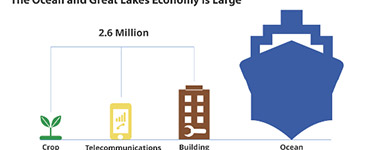
The Ocean and Great Lakes Economy
Also Noted
- Examining Flood Exposure Data
- Developing a Baseline for Recreation and Tourism
- Incorporate Green Infrastructure into GIS Projects
- “Be Current Smart” in the Great Lakes this Summer

May 2015
Green is the New Gray Infrastructure
Also Noted
- Assessing Beach and Dune Susceptibility
- Analyzing Impacts of Impervious Surface on Water Resources
- Standardize Benthic Data Sets Easily
- How to Value a Community’s Beaches

April 2015
April is tsunami awareness month in Hawaii
Also Noted
- Estimating the Economic Contribution of a Working Waterfront
- Sharing Green Infrastructure Solutions with Residents and Businesses
- Viewing Ocean Data Has Never Been Easier
- New Case Studies Show How the U.S. is Prepping for Climate Change
March 2015
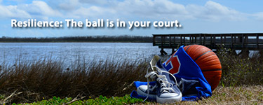
Resilience: The Ball is in Your Court
Also Noted
- Partnering to Develop High Quality Land Cover Products
- Understand Local Flooding Issues and Potential Solutions
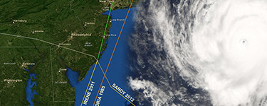
- Explore Past Hurricane Tracks and Information – Now Easier Than Ever
- GeoTools Registration Is Still Open!

February 2015
February is National Estuaries Month
Also Noted
- Mapping the Ocean’s Recreational Uses
- Visualizing Local Sea Level Rise Scenarios
- Want to Make Sure your Project Rocks?
- New Interactive Storm Surge Inundation Map

January 2015
Storm Surge: It's Not Just from Hurricanes
Also Noted
- Register for the Coastal GeoTools Conference
- Identifying Energy Infrastructure at Risk from Sea Level Rise
- Ensuring Safe Anchoring with Vessel Traffic Data in Florida
- Calling all Visual Learners

December 2014
Coastal GeoTools 2015 Conference
Also Noted
- Characterizing Fish Habitat within the Northern Gulf of Mexico Coastal Waters
- Using Lidar to Plan for Sea Level Rise in Oregon
- U.S. Climate Resilience Toolkit Now Live
- See Ecosystem Services in Action

November 2014
New Tools and Information for Digital Coast
Also Noted
- Mapping Ecosystem Habitats along the Lower Columbia River
- Assessing Climate Change and Coastal Hazards in Kaua‘i
- Hot Off the Press: Workbook for Climate Change Preparation
- Insights into Coastal Management Needs

October 2014
Two Offices are Joining Forces for Coastal Management
Also Noted
- Leveraging Partnerships to Fulfill Multiple Land Cover Data Needs
- Prioritizing Wetland Restoration Efforts in Wisconsin
- Coastal Defense App Wins Esri Global Disaster Resilience Challenge
- Want Help Writing a Strategic Plan?

September 2014
Build Resilience with the Digital Coast
Also Noted
- Communicating Flooding Risks around the Great Lakes
- Locating and Assessing Western Lake Erie’s Restorable Wetlands
- If a Picture is Worth 1,000 Words, How Much is a Map Worth?
- Submit Your GeoTools Abstract

August 2014
Back to School for Coastal Managers
Also Noted
- Providing Climate Education Aids for a Changing Chesapeake Bay
- Identifying Restorable Wetlands in Ohio
- Updated Elevation Inventory Data Now Available
- Save the Date: Coastal GeoTools is Back!

July 2014
CCAP Land Cover Atlas Updates
Also Noted
- Assessing Seagrass Vulnerability along Florida’s Gulf Coast
- Planning for Resilient Coastal Communities in New York
- Put Adaptation Principles into Practice with New Guide
- So Much to Discover in the GeoZone Blog
June 2014
Hurricane Preparedness
Also Noted
- Creating a Customized Sea Level Rise Viewer to Assist Planners in Florida
- Informing Ocean Planning Efforts with Authoritative Data
- Registration Open for Summit 14
- New Look, Same Great Data on MarineCadastre.gov

May 2014
Sea Level Rise Viewer Expanded
Also Noted
- Visualizing Coastal Flooding Vulnerabilities to Plan for Resilience in New Jersey
- Providing Easily Accessible Maps to Aid Ecosystem Restoration in the Gulf of Mexico
- Learn About Vessel Tracking in our Upcoming Webinar
- Newsletter Focuses on Coastal Counties

April 2014
Tsunami Awareness
Also Noted
- Determining Exposure Sensitivity to Tsunami Hazards in Oregon
- Creating Fisheries Regulatory Boundaries in the Gulf of Mexico
- New Needs Assessment Guide
- Hawaii Tsunami Information Delivered to Your Phone

March 2014
Economics: National Ocean Watch (ENOW)
Also Noted
- Conveying the Visual Impacts of Small Docks and Piers in Massachusetts
- Partnering to Map Oceans and Coasts for Multiple Needs in North Carolina
- So Many Trainings, So Little Time
- Better Data Required: The Economics of Extreme Weather

February 2014
3-D Ocean Mapping
Also Noted
- Reducing Whale Fatalities on the California Coast
- Increasing Resilience in the San Francisco Bay Area
- Stay Up-to-Date on Digital Coast Data
- Coastal Colleagues Holistic Coasts: A Summary from the National Flood Policy Forum

January 2014
Social Coast Forum 2014
Also Noted
- Planning for Sea Level Rise Adaptation at the Site Scale in New Jersey
- Examining Flood Exposure Data along the Mississippi and Louisiana Coasts
- New Look for the Digital Coast Website
- Register Now for the NACo Legislative Conference