September 7, 2016, 11:57 PDT
An ice-tronaut prepares
Greenland is one of the few places that’s harder to get to than outer space

I’m going to Greenland. I told my brother, and he replied, “Oh cool, I’m headed to Ireland.” That’s the typical response, as if Greenland were just some place one could book a ticket to, with commercial airports, and hotels, and restaurants and stuff. But … no, Greenland is different. It’s actually not an independent country, for example. (It’s a territory of Denmark.)
The other response I keep getting is that dumb, corny comment about it not being green. So it seems like the only thing we collectively understand about Greenland is that it’s a place to go and it has a hypocritical name.
But that is just so wrong. My husband and I finally got on the same page this morning when he opened the Google Maps satellite view of Kangerlussauq Airport, where I’m scheduled to land. “Oh,” he said. “It’s a barren dirt strip in the middle of nowhere and nothing.”
At last, an acknowledgement of the truth. The only place that’s harder to get to than Greenland is outer space. I know that sounds funny, but I’m not even kidding. (Okay, okay, Antarctica is also hard to get to, along with the Marianas Trench. Ugh.)
I first became aware of how little we know about Greenland when I was creating NASA’s Global Ice Viewer for our climate website. I found shots from Alaskan glaciers that dated all the way back to the late 1800s for the gallery. Gents with top hats and ladies in bustles with Victorian cameras stood on the ice. But Greenland? Photos taken before the 1980s are extremely rare.
And while most people understand that increased atmospheric temperatures have been melting the ice sheet from above, global warming has also been increasing ocean temperatures. And this means the ocean waters surrounding Greenland are also melting the ice sheet from around its edges.
Which is the reason I’m headed up there with NASA’s Oceans Melting Greenland (OMG) campaign in the first place: to measure the temperature and salinity of those unknown waters. See, the fresh water that flows into the ocean from ice melt is about 0 degrees and less dense, so it floats right at the sea surface. The North Atlantic Ocean Water is about 3 or 4 degrees, salty and denser, so it sits right below the fresh melt water. And these two waters don’t really mix much. When the 3- or 4-degree North Atlantic Ocean Water gets in contact with Greenland’s ice sheet, it’s warm enough to melt it.
But no one knows the melt rate yet. No one.
Even though Greenland’s melting ice sheet impacts each and every one of us right now. The rate of ice melt will determine how much sea level rise we’re going to get, 5 feet or 10 feet or 20, everywhere, all over planet Earth, not just in Greenland, but at coastlines near you and me.
This is where that whole NASA “exploring the unknown” theme comes in. Next week, the OMG team (including yours truly) will be in Greenland on NASA’s G-III aircraft. We’ll spend five weeks flying around the entire coastline, measuring the salinity and temperature of the coastal waters by dropping 250 Aircraft eXpendable Conductivity Temperature Depth (AXCTD) science probes through a hole in the bottom of the plane. The reason we’re going in September is that’s the warmest time of the year in the ocean, the ice will reach its lowest extent and we’ll be able to measure as much of the coast as possible. The plan is to repeat the same mission for five years to find out what the melt rate is and how much that rate is increasing.
Am I excited? Yes, beyond. Aside from the science preparation, it took months and months of personal prep. I passed a Federal Aviation Administration medical exam, then got trained in First Aid, CPR, AED, hypoxia, disorientation, survival, and hearing conservation, and then had to buy steel-toed shoes, which are required to fly on that NASA plane. Today, I am psyched beyond belief.
Why else would anyone work so hard to do something? Just like the rest of the team, I hope our work really makes a difference.
Find out more about Oceans Melting Greenland.
View and download OMG animations and graphics.
Thank you for your comments.
Laura
Oceans Melting Greenland is part of NASA Earth Expeditions, a six-month field research campaign to study regions of critical change around the world.
August 25, 2016, 12:40 PDT
Houston, we have a problem
... it's sea level rise.

Galveston Bay near NASA's Johnson Space Center.
Around the Houston, Texas coast near NASA’s Johnson Space Center, reminders of Hurricane Ike are everywhere. You can pick up Hurricane Ike souvenir t-shirts, it’s the name of the kicking-est drink on the two-dollar taco Tuesday menu and the spiciest sauce at the barbeque joint down the road. And even though Ike occurred back in 2008, it remains etched on the collective memory of this area as the costliest tropical cyclone ever recorded to hit Texas. It’s Ike, Ike, everywhere.
Yet what would happen to these low lying areas if climate change causes more hurricanes to form or the ones that do form become more intense? Under Hurricane Ike, there was a 12-foot storm surge. Now add that on top of an extra 8 or 17 inches of projected sea level rise over the next few years from climate change.
Sitting in Johnson Space Center’s Operations Office, I can see Galveston Bay out the window. But that’s typical. The geography of JSC is so flat that you can pretty much see the Bay out of just about any south-facing window. I’d noticed Houston’s astounding flatness flying in the day before. There were lakes, ponds and some flooded areas, as it had been raining recently. But not as much as a hill in sight.
I was talking with Joel Walker, JSC’s director of Center Operations, and Stacy Shutts, JSC’s Sustainability Program specialist, about how Walker’s Office of Strategic Infrastructure has incorporated climate change into his organization’s daily thinking. See, JSC is like a city of 7,000 people on 1,620 acres southeast of downtown Houston, and it’s Walker who keeps the place running. His office is responsible for climate mitigation and adaptation. And anyone who has a project that will impact the environment in some way has to first address it with the environmental office, which then guides them in fulfilling the project within guidelines.“There’s an environmental benefit to consolidation. We save on maintenance and energy.”
“Our lake goes into Galveston Bay, which goes into the Gulf of Mexico, so sea level rise comes up this way,” Walker said, gesturing out the window as he explained how climate change considerations have been incorporated into the master plan for where and what buildings get built over the next 20 to 25 years.
NASA loves a challenge
In 2015, Executive Order 13693 established a set of environmental challenges and goals for all federal buildings and requires all U.S. Federal Agencies to create a Strategic Sustainability Performance Plan. See NASA’s plan here. Our sustainability goals include reducing greenhouse gas emissions, petroleum use, and energy consumption in buildings; acquiring energy efficient products; and increasing renewable energy. The goals also include evaluating climate change risks to identify and manage the effects of climate change on the agency’s operations and mission, in both the short and long term. A team of Climate Adaptation Science Investigators (CASI) at NASA took this on.
Since NASA always loves a challenge, Walker and his team tried to follow all the required regulations, meet all the executive orders and then try to go beyond that. He ended up promoting a sustainability culture that permeates the entire organization.
Another part of this initiative includes reducing the square footage footprint. “There’s an environmental benefit to consolidation,” he said. We save on maintenance and energy.” One new science building under construction is less than 90 percent of the square footage of the seven older buildings it will replace and will be certified LEED Silver.“One way of thinking of stewardship or ethics is thinking it’s for somebody else."
Since JSC sits just 13 feet above sea level at its lowest point and 22 feet at its highest, Walker and his team have to address sea level rise and climate change for all new building proposals on site. And although JSC hasn’t been flooded yet, they started demolition in the lowest lying area, and the site where construction is happening is 17 feet above sea level. Yes, that’s their “hill.”
Thinking long term, for others
“One way of thinking of stewardship or ethics,” said Shutts, “is thinking it’s for somebody else. If you’re thinking in a long-term range for your business or organization, you have to plan for the next centuries ‘cause we want to be around longer than that.” Of course we want JSC to be around for generations to come. It’s historic. It was established in 1961 as the Manned Spaceflight Center and Mission Control Center for the U.S. human space flight program.
So if and when Ike’s younger brother Mike or Spike or Van Dyke washes into town, you can be sure Walker and his team will be ready for it.
Thank you for your comments.
Laura
Walker’s sustainability management approach also focuses on areas of energy and water reduction, green purchasing, reducing the generation of hazardous waste and increased diversion from landfilling of waste through recycling initiatives. Under Walker’s direction, the JSC constructed eight certified green buildings that use 100 percent green power and average 35- to 40-percent reductions in energy and water consumption of comparable facilities. With Walker’s leadership, JSC has reduced potable water use by 15 percent annually, or more than 60 million gallons per year, since 2009, and over the past two years has composted more than 85,000 pounds of food waste.
August 10, 2016, 14:31 PDT
TEDx Talk: Run toward the challenge of climate change. I dare you.
Everyone you admire, everyone who’s accomplished greatness, faced obstacles along the way. Think about it. Everyone. The most impressive athletes, artists or public figures found their way to success by moving through and overcoming roadblocks.
Today, as my morning jog turned into a run and then a sprint, I felt my power and strength as a woman to keep pushing forward. No. Matter. What.
At the entrance to NASA’s Jet Propulsion Laboratory where I work, there’s a sign that says “Dare Mighty Things.” The way I see it, that sign is talking directly to me. “I dare you,” it says. Not to try something easy, but to run toward the challenge of climate change with confidence, strength and courage. And now I dare all of you.
August 2, 2016, 11:27 PDT
Greenland on the edge
Where ice meets water at the bottom of the sea

Greenland's southwestern coastline in July and August 2015 during Phase 1 of the Oceans Melting Greenland (OMG) mission's TerraSond / Cape Race Bathymetry survey. Credit: NASA/JPL.
A person can look at a thing over and over again before finally seeing it for the first time. That’s how I felt standing in front of an Arctic map at the University of Washington in Seattle. I gazed at the northwest coastline of Greenland, north of Baffin Bay, up where the Canadian Queen Elizabeth Islands come close to Greenland.
Of course I’ve looked at Arctic maps before, from a zillion different angles. Normally I’m the one pointing and explaining. “Look at how small the Arctic area is. It’s a shallow sea, mostly surrounded by continents and islands where sea ice forms and gets trapped,” I say, encouraging folks to get as excited as I am about this remote part of the planet that’s chopped up, spread out and distorted by most maps. But this time, standing next to James Morison, senior principal oceanographer from the University of Washington, I was the one listening, looking closely and being amazed.
A person can look at a thing over and over again before finally seeing it for the first time.
We were in the hallway of the Applied Physics Laboratory’s polar science wing, taking a break between Oceans Melting Greenland (OMG) science team presentations. The walls were lined with photos of teams out on glaciers, ice drilling equipment, ice sheets of the world and grand ice-covered landscapes. Ice, ice and more ice, and penguins. There were pictures of polar bears and narwhals, too. But Greenland’s jagged coastline had me captivated. The islands, the convolutions, the fjords: phenomenal, mindboggling. I couldn’t take my mind off it.
But the Oceans Melting Greenland team is doing more than looking at maps of Greenland. Way more. “We’re trying to look under the ice,” Principal Investigator Josh Willis told me. “What is the sea floor like under there? What is the interface between where the bottom of the ice sheet reaches out over the seawater and down into the ocean?”
The seawater around 400 meters (1,312 feet) deep is 3 to 4 degrees Celsius (5 to 8 degrees Fahrenheit) warmer than the water floating near the sea surface. And the shape of the sea floor (bathymetry) influences how much of that warm, subsurface layer can reach far up into the fjords and melt the glaciers. The OMG team wants to measure how much of that warm water could be increasing due to climate change.
What will the future hold? Will we see 5 feet of sea level rise … or 10 or 20?
And even though Greenland feels untouched and remote, feels so “Who cares?” we all need to be concerned about its complex coastline and the rapid pace of its melting ice sheet. NASA’s GRACE satellites observed Greenland shedding a couple trillion—with a “t”—tons of ice over the last decade, and the rate of melt is increasing. So that winding coastline and those unfamiliar fjords have already impacted all of us—yes, that means you—undoubtedly, no matter how far away or how far inland you reside.
As each of the dozen or so OMG members took his or her turn updating the team on their most recent topography, temperature and salinity measurements, I noticed a trend. Everyone kept repeating the phrases “never been surveyed before,” “it’s a very tough area,” and “these fjords are so very small, they have no names and have never been visited before.” They are literally exploring these unknown areas in detail for the first time.
My mind drifted off to the edge of that unimaginably complicated winding coastline, that unknown place where ice meets water meets seafloor, where the ice is melting as fast as we can measure. And I had to stop the group to ask why. Specifically, why is it so tough? Why has no one been there before? It turns out this area is difficult to navigate because big chunks of remnant sea ice clog up the water. The crew has to snake in between floating icebergs and weave in and out of the narrow fjords. It’s rather treacherous. And weather conditions can be challenging up there. The other reason this area is so unknown is that the glacier has retreated so recently that the coastline is changing as fast or even faster than we can study it.
Last summer, a small group that included UC Irvine graduate student Michael Wood sailed on the M/V Cape Race deep into some of the most jagged areas around southeastern Greenland, which, according to Co-Investigator Eric Rignot, is the “most complex glacier setting in Greenland.” After more than 7,871 kilometers (4,250 nautical miles) and more than 300 Conductivity, Temperature Depth (CTD) casts, the first bathymetric survey was completed.NASA’s GRACE satellites observed Greenland shedding a couple trillion—with a “t”—tons of ice over the last decade, and the rate of melt is increasing.
Over the next five years, OMG will measure the volume of warmer water on the continental shelf around Greenland to figure out whether there is more warm water entering the fjords and increasing ice loss at the glacier terminus.
Here are some details about the OMG plan:
- Every year for four years, survey glacier elevation near the end of marine-terminating glaciers around Greenland’s coastline using NASA’s airborne synthetic aperture radar altimeter GLacier and Ice Surface Topography INterferometer (GLISTIN-A).
- Every year for five years, deploy 250 Aircraft eXpendable Conductivity Temperature Depth (AXCTD) probes to measure temperature and salinity of the waters around Greenland from one of NASA’s G-III aircraft.
- Use a ship with multi-beam sonar to measure bathymetry of the seafloor up very close to the extremely jagged coastline of Greenland, as well as a small vessel with a single beam going up into small places, driving up fjords and getting as close to glaciers as is safe.
- Collect gravity measurements from small planes in Northwest, Southeast and Northeast Greenland to help map the sea floor in places the ships cannot go.
Find out more about Oceans Melting Greenland.
View and download OMG animations and graphics.
Thank you for your comments.
Laura
Oceans Melting Greenland is part of NASA Earth Expeditions, a six-month field research campaign to study regions of critical change around the world.
July 14, 2016, 14:45 PDT
Shuffle and flow: Where does carbon come from, and where does it go?
Atmospheric Carbon and Transport (ACT) - America
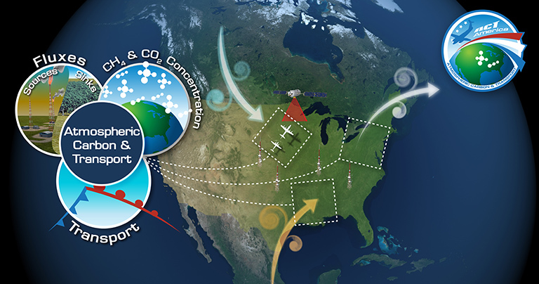
ACT-America, or Atmospheric Carbon and Transport – America, will conduct five airborne campaigns across three regions in the eastern United States to study the transport and fluxes of atmospheric carbon dioxide and methane.
The average amount of carbon dioxide in Earth’s global atmosphere is 400 parts per million (ppm), but according to Ken Davis, Atmospheric Carbon and Transport - America (ACT-America) principal investigator, areas near agriculture like cornfields can consistently run about 10 ppm lower in the summertime. That’s because terrestrial ecosystems like trees and corn suck about a quarter of our carbon dioxide emissions out of the atmosphere.
Thank you, trees and corn.
But wouldn’t you like to know exactly where this is happening, and by how much? Does the amount of carbon dioxide taken up by farms and forests change across seasons, across weather patterns? And even more important, will these ecosystems still be able to continue pulling our carbon pollution out of the atmosphere for us 50 years from now, especially if our climate changes unfavorably for these biological systems? Will dead trees start releasing carbon dioxide back into the atmosphere? It’s as if the forests and farms are “Get Out of Jail Free" cards and we’re not sure for how long the free pass will be good.
It’s as if the forests and farms are “Get Out of Jail Free" cards and we’re not sure for how long the free pass will be good.
See, scientists have been measuring carbon dioxide and methane on a global basis. But we’d like to understand the mechanisms that are driving biological sinks and sources regionally. And we’d like to measure these greenhouse gases so that we can know if and when we’ve succeeded in reducing our emissions.
Davis explained that right now, most of our knowledge about regional sources of methane and carbon dioxide comes from a ground-based network of highly calibrated instruments on roughly 100 towers across North America. Yet being able to understand the regional sources and sinks of these two greenhouse gases is crucial to being able to predict and respond to the consequences of a changing climate.
“We don’t have all the data we need? That’s unbelievable,” I said, shocked. How is that even possible in 2016?” But Davis kept repeating: “No, we definitely don’t have enough data density.” Indeed, we take our data for granted, even as we continue burning fossil fuels.
So on July 18th, Davis and his team will head out to the first of three study areas for a two-week stint. These three regional study areas were chosen to represent a combination of weather and greenhouse gas fluxes across the U.S. The Midwest has a lot of farms and therefore has an agricultural signal. It’s also the origin point of cyclones. The Northeast forests are different than the Southern coastal forests, which will give us both types of data. The Southern coastal weather, storms and flow off the Gulf of Mexico are unique, and there’s oil and gas development in both the Mid-Atlantic and Southern regions. This means that between these three study areas, the team will be able to observe a wide range of conditions.
In addition to measuring regional sources and sinks of carbon dioxide and methane, ACT-America is planning to fly on a path right underneath NASA’s OCO-2 satellite to measure air characteristics, provide calibration and validation and make OCO-2’s data more useful. The mission will also fly through a variety of weather systems to find out how they affect the transport of these greenhouse gases.
Davis told me he’s “excited to fly through cold and warm fronts and mid-latitude cyclones to find out how greenhouse gases get wrapped up in weather systems.”
Find out more about ACT-America here.
Thank you for reading.
Laura
ACT-America is part of NASA Earth Expeditions, a six-month field research campaign to study regions of critical change around the world.
July 5, 2016, 16:06 PDT
How NASA prepares future climate scientists for careers in the sky
We receive a lot of questions, especially from students, asking us for information about how to get a job at NASA. Well, there’s more than one way to get hired here. But one of the most awesome methods we have of training young scientists and preparing them for potential hire here (or a great position anywhere) is by recruiting university undergraduates for our Student Airborne Research Program (SARP).
SARP is our eight-week summer program for college seniors with academic backgrounds in engineering or physical, chemical or biological sciences and an interest in remote sensing. We select about thirty students based on their academic performance, their interest in Earth science and their ability to work in teams. These students receive hands-on research experience on NASA's DC-8 airborne science laboratory. Yup, they get to fly on a modified NASA plane out of NASA’s Armstrong Flight Research Center, in Palmdale, Calif., where they help operate instruments onboard the aircraft and collect samples of atmospheric chemicals.
Did I already say “awesome”? Oh right, I did. Well, I’ll say it again: Awesome.
Many students apply hoping to gain more research experience for graduate school. The whole air sampling team, which is exactly what it sounds like, collects air from around the plane in canisters as it’s flying through different locations and altitudes at different times. The air enters the plane from the outside through an inlet, a pipe sticking out of the plane. The student scientists open the canisters, allowing air from outside the airplane to suck into the can. Then they take the air samples back to the lab at the University of California, Irvine, for analysis and interpretation.
SARP students analyze the air samples for hydrogen, carbon monoxide, carbon dioxide, methane, hydrocarbons, nitrates, oxygenates and halocarbons. Research areas include atmospheric chemistry, air quality, forest ecology and ocean biology.
Once the airborne data has been collected and analyzed, the students make formal presentations of their research results and conclusions. Over the past seven years, the program has hosted 213 students from 145 U.S. colleges and universities. And this year we look forward to helping our latest crop of SARP students gain research experience on a NASA mission, work in multi-disciplinary teams and study surface, atmospheric and oceanographic processes.
Find out what SARP students thought about their experience here.
Find out more about SARP and other Airborne Science Programs here.
Thank you,
Laura
SARP is part of NASA Earth Expeditions, a six-month field research campaign to study regions of critical change around the world.
June 20, 2016, 03:15 PDT
A sea slug changed my life

This underwater photo of a sea slug was captured with a close-up lens in Monterrey, Calif., by my first SCUBA instructor, Thomas Chapin circa 1985.
At 8 p.m. after a long day of work in the Houston humidity, Derek Rutavic, manager of the NASA Gulfstream-III that will head back to Greenland this fall, and I were in the back of the plane singing One Direction’s "Drag Me Down" over the high frequency radio system. It was stifling hot, getting dark and we were tired and hungry.
But Oceans Melting Greenland (OMG) Principal Investigator Josh Willis and Project Manager Steve Dinardo, too busy to take off their sweaty fire retardant flight suits, were troubleshooting electronics at two racks of computers, and they’d asked Rutavic to get on the headset to find out if the headset noise was interfering with the high radio frequency data signal the ocean science probes were sending back to the plane. Rutavic sat on an empty science probe container, while I lounged on one of the sofas singing along in awe of the amount of hard work this team was putting in.
We’d been up early, flown multiple test flights, worked through lunch. And all of this after days and days of maintenance, and weather delays, and more hard work after more hard work. Earlier in the day, NASA T-38 supersonic jet pilot Bill Rieke flew mind-bogglingly close to the G-III to photograph the science probe deployment and determine if the technique of launching the probes through a hole in the bottom of the plane would succeed. And yes, it did. But that success merely signaled the OMG team to continue working.
And I understood exactly why this team kept going, kept moving, kept pushing on into the evening, regardless of being tired and hot and hungry. I knew exactly why they decided to keep working on the challenge. They chose to push through because they’d found something to care about, and that's always more important than our difficulties and problems. When we focus on what we really care about, we get busy doing something, even in the face of trouble. And that’s how science works.
Lessons from a sea slug
I first learned to care about the natural world around me during my junior year in college. I was in an oceanography course and we were studying sea slugs. (Yes, sea slugs.) A sea slug changed my life. Before then, I’d been, like many people, disengaged and uninterested in science. In third grade, someone came to our classroom and told us we could be the first female astronaut, and I remember thinking, “No, I couldn’t, not me.”
And now? Even though I have a job at NASA, I still feel like I don’t belong in the world of science. I feel more comfortable around athletes and artists than I do with a bunch of Ph.D.s. Maybe it’s some poorly defined stereotype that I’ve somehow bought into or some preconceived notion of how someone who does science is supposed to behave.
But those sea slugs taught me that I cared more about the natural world than I cared about the struggle of not fitting in or the challenge of the work. They appeared so delicate, small and defenseless, and I identified with that. They helped me feel connected. Noticing them forced me to wonder what else I’d start to notice if I slowed down enough to pay attention. And that connection to the natural world helped me stay committed to science, even when it was hard, even when there were problems, even when I felt like running away.
Sure, scientific experimentation, just like much of real life, includes problems, troubles, obstacles and difficulties almost every day. And while it’s true that someone, somewhere has to troubleshoot something every step of the way, we can also be excited about the effort. The OMG team understands that problems and hard work are not the exception, they are the norm. They are part of accomplishment. And it’s totally possible to thrive on these difficulties and challenges.
Look, we could be setting the world on fire right now, not by burning fossil fuels, but by our burning desire to understand our environment. Because the whole point of this experimental mission is to find out how quickly the warmer waters around Greenland are melting the second-largest ice sheet on the planet. It’s major; it’s dire; it’s intense. It’s one of the most important issues of our time.
And sitting there in the back of that plane made me think about how we, as individuals and as a society, have to find something in this world to care about. We have to find something in this world that is more important than our challenges and problems.
And you? I hope you decide to find something to care about. I hope you find something that’s important enough that you’re willing to push through your struggles, your fears and your problems to just do the work.
Find out more about Oceans Melting Greenland.
View and download OMG animations and graphics.
Thank you,
Laura
Oceans Melting Greenland is part of NASA Earth Expeditions, a six-month field research campaign to study regions of critical change around the world.
June 7, 2016, 10:12 PDT
OMG: Testing the waters to see how fast Oceans are Melting Greenland

NASA’s modified Gulfstream-III on the runway at Ellington Field Airport in Houston, Texas, with OMG scientists and engineers aboard.
We know more about the moon and other planets than we do some places on our home planet. Remote parts of the world ocean remain uncharted, especially in the polar regions, especially under areas that are seasonally covered with ice and especially near jagged coastlines that are difficult to access by boat. Yet, as global warming forces glaciers in places like Greenland to melt into the ocean, causing increased sea level rise, understanding these remote places has become more and more important.
This past spring, Oceans Melting Greenland (OMG) Principal Investigator Josh Willis led a team of NASA scientists to begin gathering detailed information about the interface between Greenland’s glaciers and the warming ocean waters that surround them. The next step in accessing this extremely remote region involves dropping a series of Airborne Expendable Conductivity Temperature Depth, or AXCTD, probes that will measure ocean temperature and salinity around Greenland, from the sea surface to the sea floor. With this information, they hope to find out how quickly this warmer ocean water is eating away at the ice.
Since no one has ever dropped AXCTDs through a tube at the bottom of a modified Gulfstream-III, the OMG team headed to Ellington Field Airport near NASA’s Johnson Space Center in Houston, Texas, for a test drop into the Gulf of Mexico. I went along for the ride.
"In position!"
The money shot
Temperature and salinity
3, 2, 1 ... drop!
AXCTD sails down
The flight path
Details, details, details
Find out more about Oceans Melting Greenland.
View and download OMG animations and graphics.
Thank you for your comments.
Laura
Oceans Melting Greenland is part of NASA Earth Expeditions, a six-month field research campaign to study regions of critical change around the world.
May 6, 2016, 02:01 PDT
Plankton and you: The science of how we're all connected to climate
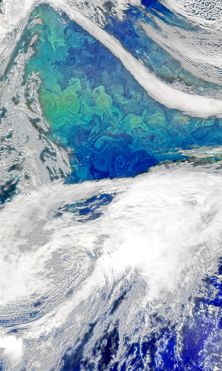
Each spring, the waters of the North Atlantic Ocean host a huge natural bloom of phytoplankton—microscopic, plant-like organisms that are important for carbon cycling and also could influence clouds and climate. Source: NASA's Earth Observatory. Credit: Norman Kuring, using VIIRS data from the Suomi National Polar-orbiting Partnership.
Every year toward end of the semester, when students have just finished their second round of exams and they’re irritable, burned out and just plain over it, I walk into the oceanography class I teach with “the plankton lecture.” They give me this look that says, “Aww, come on, you’ve got to be kidding.” But I’m obsessed with plankton, obsessed. And I want the whole world to know. Plankton are da bomb, plankton rule, plankton are the bestest, awesomest, sickest beasts ever.
So you can imagine how psyched I was to smack talk with plankton expert and principal investigator of NASA’s North Atlantic Aerosols and Marine Ecosystems Study (NAAMES) Mike Behrenfeld. He’s interested in the link between the blooming plankton food web and its influence on global climate. See, when animal plankton and bacteria munch on the plant plankton, organic compounds the plants produce get broken into itty bitty pieces. These small particles become aerosolized, which means they get lofted out of the ocean and into the atmosphere by wind and breaking waves, where they become the condensation nuclei around which water droplets form. So when these tiny creatures of the sea multiply, those bloom events end up influencing clouds.
The North Atlantic also has extremely particle-free air, so the restricted availability of these aerosols limits water in the atmosphere’s ability to form droplets. It's the ocean’s biology that might provide an otherwise rare opportunity for water droplets to condense around. And that means a small amount of organic aerosols can go a long way. NAAMES “is an opportunity to tie the biology and aerosols together.”
I imagined being near the ocean, inhaling the salt air, feeling the moisture on my skin, in my hair. The spray reaches up, up, up, out of the sea. And just below the surface, the churning waves and frothy foam force bits of dissolved air down between the molecules of briny water. And the oxygen in that air supports life: microbes, plankton, bacteria and the food web that eats them.
“Phytoplankton, the plant plankton, are always tightly coupled with the creatures that eat them, and there are lots of things that like to eat them,” Behrenfeld explained. Oh, I’m sure they’re delicious. “The rate at which they are dying is almost perfectly matched with how fast they grow. The faster they grow, the faster they die. The only way they can bloom is if they get away from their predators. When they grow faster than the guys eating them, they’ll bloom.”
It’s that interface, the boundary zone where the atmosphere blends into the ocean and the ocean blends back into the atmosphere, the place where mixing, churning and friction form turbulence. That’s the interesting place, physically, biologically and personally. This air-water interface is also where oceanographers stick their heads out of the water and look up toward the sky to interact with atmospheric scientists who simultaneously look down from above into the water. Behrenfeld described it as working “with people in a different discipline so you get fresh ideas from another perspective and think about things in a new way.”
Behrenfeld and the rest of the NAAMES team hope this research will help them learn how changes in climate will impact ecosystems. “If you look at blooms from a traditional standpoint, that more sunlight causes more blooms, you might expect that warming would give you a bigger bloom. But phytoplankton blooms are initiated by deep ocean mixing, and if you warm the ocean, then your winter mixing depth will be less and you might have a later onset of the bloom or a smaller bloom. The potential consequences of change in blooming areas could be huge.”
Thank you for reading and for your comments.
Laura
North Atlantic Aerosols and Marine Ecosystems Study is part of NASA Earth Expeditions, a six-month field research campaign to study regions of critical change around the world.
April 28, 2016, 09:57 PDT
We're over being bummed about climate change and ready for solutions.

Modified from Wikimedia Commons.
If you’re anything like me, sometimes you feel a bit pessimistic. You can get caught in a bubble of icky vibes that bring you down. This is why I had difficulty writing about a conversation that climate communications expert Susan Hassol and I had about climate hope. We were discussing how to look toward the reality of climate change without freaking out or turning away. We agreed that being afraid is not helpful, and that a better response to the problem includes facing climate change with courage, optimism and integrity, while still feeling all of the stressful emotions, even though that’s hard.
Then I went out to Riverside, Calif., where I gave a speech at the American Public Works Association, a group of city planners, public works officers, contractors and consultants who draw up plans for building roads, bridges, buildings and landscaping. I learned about an extremely drought-tolerant grass species especially developed to avoid wasting water on golf courses. I sat near a guy who consulted a number of cities across California on their plans for multi-use pedestrian/cyclist/automobile roads.
In an instant, I understood Hassol’s point: “Of course there’s a huge problem, but if you keep hitting people with problems, they just want to pull the covers over their head. Focusing on the solutions is energizing, it’s inspiring, as opposed to leaving people so depressed that they have no energy to act. There really is a lot to be positive about.”
Look, I know it’s really hard to be optimistic when you’re down. So the best antidote to fight off the climate blues, according to Hassol, is to take action. “I do more work, give more talks, work with more scientists, get out there, and give people real hope. I also balance my reading,” she continued. “For every couple of articles I read in science journals about the melting poles, the hottest year on record, the worst fire season on record, the flooding, I try to look at what’s happening on the solutions side: the growth in solar and wind, the improvements in the economics of renewable energy, the ambitious action taking place in cities, states and countries around the world.”
“What makes people happier is more time to do the things that really matter,” Hassol continued. “Stuff is not what makes us happy. Relationships are what make us happy, walks in the woods, reading books with your kid. None of those things are based on consuming. This is about having more integrity in our lifestyle choices, about having more time, more peace. We can grow personally, without always growing the economy.”
There’s an extra positive bonus, she added: “You’ll know that you’re making a positive contribution to the world.”
Climate change is not distant in time or space. It’s in our own backyard now, affecting all of us. And we’re going to pay, one way or another, or as Hassol then reframed it more positively, “The sooner we reduce emissions, the less it will cost. So let’s do as much as we can, as fast as we can.”
She excitedly went on to list a number of positives, namely the big increases in renewable energy use across the board, from individuals to cities:
- Scotland generated nearly 60 percent of its electricity with renewables in 2015 and is aiming for 100 percent.
- Nine massive U.S. companies pledged to go 100 percent renewable, including Nike, Walmart, Goldman-Sachs, Johnson and Johnson, Proctor and Gamble, and Starbucks. This is a good financial investment, given that the most ambitious companies have seen a 27 percent return on their investments. They’re not doing it because they love polar bears; they’re doing it because it’s good for their bottom line.
- Goldman-Sachs in particular says it’s going for 100 percent renewables by 2020.
Between climate change and El Niño, 2016 will likely break the global temperature record. But we’ll potentially have a turning point with renewables, so this year could be big. Listening to her voice got me excited, even though I’d woken up melancholy.
I wondered when climate change and a strong push for renewables will make its way to the top of the inbox. “The thing that gives me the most hope,” she said, “is that I feel we’re right at that inflection point right now. It’s not a time to let up, it’s a time to push hard.”
Thanks for reading. I look forward to your comments.
Laura