


GEDI data products are designed to answer key science questions on the role of ecosystem structure now and in the future.
GEDI science data products include footprint and gridded data sets that describe the 3D features of the Earth. These data products are assigned different levels, which indicate the amount of processing that the data has undergone after collection. All products are publicly available, with the lower level products (L1 & L2) from NASA’s Land Processes Distributed Active Archive Center (LPDAAC) and the higher level (L3 & L4) from the ORNL DAAC. Data are initially transferred to the GEDI Mission Operations Center (MOC) at the Goddard Space Flight Center that deploys acquisition planning on a weekly basis, and then processed through the Science Operations Center (SOC) to distribute science data products to the above DAACs.
The physical theories, mathematical procedures and model assumptions that are used in the creation of these data products are described in the Algorithm Theoretical Basis Documents (ATBDs). These can be found here.
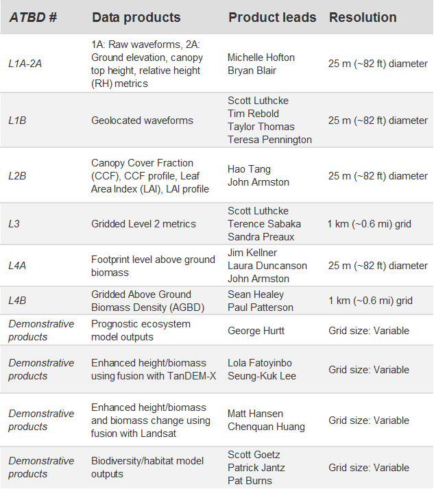
Level 1 - Geolocated waveforms
The raw GEDI waveforms as collected by the GEDI system are geolocated by our science team.
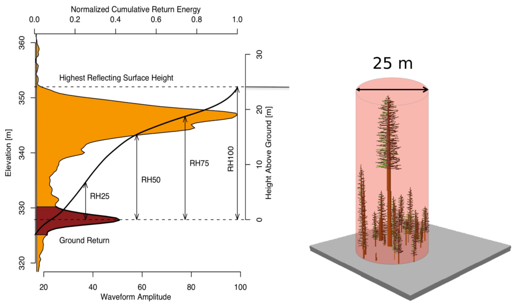
Level 2 - Footprint level canopy height and profile metrics
The waveforms are processed to provide canopy height and profile metrics. These are values calculated directly from the waveform return for each footprint such as terrain elevation, canopy height, RH metrics and Leaf Area Index (LAI). These metrics provide easy-to-use and interpret information about the vertical distribution of the canopy material.
Level 3 - Gridded canopy height metrics and variability
Level 3 products are gridded by spatially interpolating Level 2 footprint estimates of canopy cover, canopy height, LAI, vertical foliage profile and their uncertainties.
Level 4A and 4B - Footprint and Gridded Aboveground Carbon Estimates
Level 4 products are the highest level of GEDI product and represent the output of models. Footprint metrics derived from the L2 data products are converted to footprint estimates of aboveground biomass density using calibration equations. Subsequently, these footprints are used to produce mean biomass and its uncertainty in cells of 1 km using statistical theory.
Demonstrative products
These are science products that demonstrate a range of outputs that are enabled using GEDI data. Unlike other data products, these outputs are created only for limited domains.
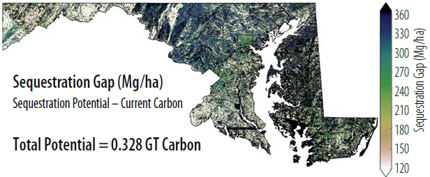
Prognostic ecosystem model outputs
The Ecosystem Demography model (ED) provides estimates of carbon stocks and fluxes over large areas at fine resolution. Because it is a height-structured model, ED can be initialized with vegetation structure information derived from lidar. When initialized with vegetation structure information from GEDI, ED produces high spatial resolution estimates of the carbon sequestration potential of tropical and temperate forests under multiple Intergovernmental Panel on Climate Change (IPCC) climate and land use change scenarios. These simulations provide realistic assessments of the role of policy, through its effects on land use and development, on atmospheric carbon dioxide concentrations.
Enhanced height/biomass using fusion with TanDEM-X
TanDEM-X is an interferometric synthetic aperture radar mission (InSAR) consisting of two spacecraft that simultaneously image a location on the Earth. High-resolution forest height maps can be generated from TanDEM-X acquisitions and be improved using GEDI observations. These height maps in turn are useful to upscale GEDI lidar biomass estimates. Advanced algorithms are being developed that combine the wall-to-wall mapping capability of TanDEM-X with the spatial sampling of GEDI lidar to provide improved estimates of height and biomass at much finer resolution and accuracy than what can be achieved by either mission alone. This work is part of a formal collaboration between GEDI and the German Space Agency (DLR).
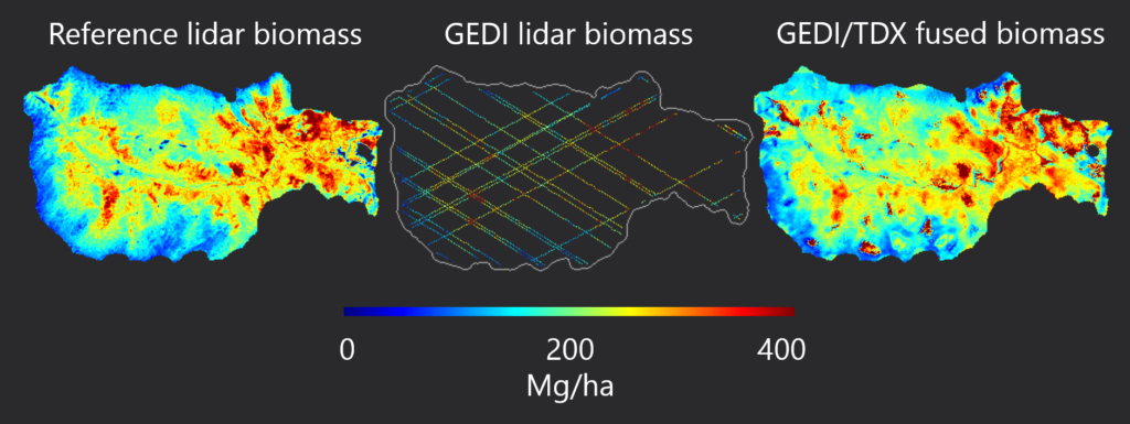
Biomass estimates for Hubbard Brook Experimental Forest, New Hampshire, USA, created by fusing GEDI and 25 m Tandem-X (TDX) data.
Enhanced height/biomass using fusion with Landsat
GEDI’s footprint size and accurate geolocation allows fusion with Landsat maps of vegetation change to provide high spatial resolution estimates of vegetation height and change in aboveground carbon stocks at annual to 5-year time scales. When combined with forest structure observations from GEDI, forest area and forest disturbance estimates from Landsat provide some of the most accurate estimates to date of carbon emissions from deforestation.
Biodiversity and habitat models
Indices of habitat heterogeneity are developed using both vertical and horizontal information on vegetation height distribution from GEDI waveforms as indicators of habitat quality and floristic and animal diversity at multiple scales. Predictive models are developed for specific areas, depending upon the availability of in situ biodiversity data for model calibration and validation. Vegetation loss and disturbance maps derived from Landsat are then used to estimate potential impacts of land use on habitat quality and biodiversity.
