
California Water Science Center
Data and Tools
Basic hydrologic data collection, processing, analysis, dissemination, and archiving are major parts of the California Water Science Center program. Streamflow data, for example, are used for flood and water-supply forecasts, planning and design, river regulation, streamflow statistics, and research investigations. Much of the data are available on a near-real-time basis by satellite telemetry.
Current California Streamflow Conditions
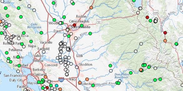
Real-time streamflow data from automated equipment, representing the most current hydrologic conditions.
Get Streamflow Data >>California Groundwater Quality
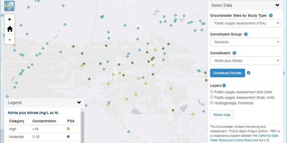
This interactive webmap plots water-quality data from domestic and public-supply wells sampled by the USGS for the California GAMA Priority Basin Project, and allows users to download datasets.
Water Quality Data
National Water Dashboard (NWD)
The National Water Dashboard (NWD) is a mobile, interactive tool that provides real-time information on water levels, weather, and flood forecasts - all in one place on a computer, smartphone, or other mobile device. The NWD presents real-time stream, lake and reservoir, precipitation, and groundwater data from more than 13,500 USGS observation stations across the country.
 - Black (TM)")
Aquifer test data for the Belridge multiple-well monitoring site (BWSD), Kern County, California
To determine aquifer characteristics, pneumatic slug tests were performed on selected zones and aquifers at a monitoring site near the North and South Belridge oil fields in the Southern San Joaquin Valley in Kern County. On November 19th and 20th, 2018, pneumatic slug tests were performed at five monitoring wells located at the multiple-well groundwater-monitoring site BWSD (28S/21E-08
Numerical Simulation of 1D Advection-Dispersion Equation of Conservative Tracer with Oscillating Tidal Flows
Model archive for a numerical simulation of the one-dimensional advection-dispersion equation of a conservative tracer with oscillating tidal flows. The numerical simulation was used to examine how a conservative tracer evolves along a tidal channel. Scenarios were run to examine the effects increased dispersion, increased and decreased mixing at a channel junction, and increased advection. C...
Electrical resistivity tomography data collected near a groundwater replenishment and reuse project, Yucca Valley, San Bernardino County, California, 2019
Hi-Desert Water District (HDWD) is constructing a wastewater treatment plant as part of a groundwater replenishment and reuse project (GRRP) in the east hydrogeologic unit (Nishikawa, and others, 2003) of the Warren Valley Basin (7-012) (California Department of Water Resources, 2016) in Yucca Valley, CA. The HDWD plans to use reclaimed wastewater for managed aquifer r
Background electrical resistivity tomography data, 2019
Electrical resistivity Tomography (ERT) is a direct current geophysical method that is used to estimate the subsurface distribution of the electrical resistivity (measured in ohm-meters, or ohm-m) of a material, and is based on the assumption that measured electric potentials (voltages) near current carrying electrodes are influenced by the electrical resistivities of the underlyi
Assessment of water-quality in the California Sacramento-San Joaquin Delta during a North Delta directed flow action: August - October 2018
This report documents the spatial and temporal variability of nutrients and related water quality parameters at high spatial resolution in the North Delta in the Sacramento-San Joaquin River Delta of California, USA. The data set includes nitrate, ammonium, phosphate, dissolved organic carbon, temperature, conductivity, dissolved oxygen, turbidity, and chlorophyll . Data-collect
Data for Groundwater-Quality and Select Quality-Control Data for the Colorado Plateaus Principal Aquifer
Groundwater samples were collected from 60 public supply wells in the Colorado Plateaus principal aquifer. Water quality evaluations of groundwater for drinking water at public supply depths were made with the purpose of summarizing the current quality of source water (that is, untreated water) from public supply wells using two types of assessments; (1) status: an assessment that
Discharge, nutrient, and suspended sediment data for selected streams in the Lake Tahoe watershed
A time series of nutrient and mean daily discharge data were used to create models of daily concentration and loads for selected streams of the Lake Tahoe watershed. A total of 15 sites have records ranging from as early as 1972 to 2017. Nutrients in the data set include nitrate, ammonium, Kjeldahl Nitrogen, orthophosphate, and total phosphorus. Total suspended sediment concentrations a
Scientific observations of fishes in tidal wetlands of the upper Sacramento San Joaquin Delta using imaging sonar devices, derived from 2018 field data
Major tidal wetland habitat restoration efforts are planned to benefit Delta Smelt and other imperiled species in the Sacramento-San-Joaquin Delta. However, successful implementation of habitat restoration is constrained by a paucity of information on the services and functions tidal wetlands provide for fishes. This knowledge gap is largely due to the difficulties of collecting ecological...
Daily Basin Characterization Model (BCM) archive for Humboldt Bay/Eel River
This data set includes: 1) A shapefile of the Humboldt Bay Eel River (HBER) 13 sub watersheds, 2) A shape file of the streamflow gages used in calibration, and 3) Daily Basin Characterization Model (BCM) model climate inputs (minimum and maximum air temperature, precipitation, and potential evapotranspiration) and outputs of recharge and runoff for the year 2010 used t
Underwater Videographic Observations of Cultured Delta Smelt in Field Enclosures: Video clips and Summary data
All data is part of a pilot study aimed to observe Delta Smelt behavior within enclosures deployed in the wild. The enclosures used were designed by The California Department of Water Resources and UC Davis as part of their ongoing Delta Smelt enclosure deployment studies. Study 1: This data includes 16 17:43 minute videos of observations of Delta Smelt behavior in a floating field enclosu...
Pesticide constituent data from the California Groundwater Ambient Monitoring and Assessment Program Priority Basin Project (GAMA-PBP), August 2013 - May 2018, schedule 2437 constituents
This Data release presents results for pesticide constituents in 460 samples collected from domestic and public-supply wells in August 2013-May 2018 for the California Groundwater Ambient Monitoring and Assessment Program Priority Basin Project (GAMA-PBP). The samples were analyzed for 225 pesticide constituents on USGS National Water Quality Laboratory analytical schedule 2437. Results from...