News
News Releases
Browse through a comprehensive list of all USGS national and state news items.
Isaias Likely to Cause Extensive Erosion on S. Carolina Beaches
Wave-driven flooding behind dunes unlikely on SE Atlantic coast, USGS predicts
This news release was updated August 3 based on the latest coastal change forecast.
To learn more about USGS’s role providing science to decision makers before, during and after Tropical Storm Isaias, visit https://www.usgs.gov/isaias.
Mars 2020 Mission to be Guided by USGS Astrogeology Maps
FLAGSTAFF, Ariz. – When you’re planning to explore someplace new, it’s always a good idea to bring a map so you can avoid dangerous terrain. This is true whether you’re heading out for a hike on Earth or you’re landing a rover on Mars.
USGS and Partners Tracking and Removing Burmese Pythons in Southern Florida
Washington – Today, the U.S. Geological Survey (USGS), U.S. National Park Service (NPS), U.S. Fish and Wildlife Service (FWS) and Conservancy of Southwest Florida announced they have teamed up to radio-track Burmese pythons in Big Cypress National Preserve, Crocodile Lake National Wildlife Refuge and other areas of Southwest Florida.
New Study Finds the Restoration of Forests with Active Rapid ʻŌhiʻa Death Infections May Be Possible
Hilo, Hawaiʻi – For the first time, researchers have shown that native ʻōhiʻa seedlings can survive for at least a year in areas that have active mortality from Rapid ʻŌhiʻa Death, or ROD, a fungal disease that is devastating to this dominant and culturally important tree in Hawaiian forests. This information can be useful to land managers and homeowners as they prioritize conservation actions.
Food Web Dynamics Influence Mercury Movement in Colorado River, Grand Canyon
A new study describes how food web dynamics influence the movement of mercury throughout the Colorado River in the Grand Canyon. This new research from the U.S. Geological Survey and partners represents one of the first times that the movement and fate of mercury has been traced through an entire food web.
Larger than average hypoxic area expected for Gulf of Mexico
High spring rainfall, river discharge, nutrient loads into Gulf major contributors to size
USGS Crews Measure Major Flooding in Lower Michigan
U.S. Geological Survey field crews are measuring record flooding on the Tittabawassee River in Midland, Michigan, following a heavy rainfall event.
Interior and Partners Commit to Long-Term Initiative to Conserve the American Bison
10-year initiative provides framework for shared conservation goals
New USGS Map Helps Identify Where Pyrrhotite, a Mineral that Can Cause Concrete Foundations to Fail, May Occur
The USGS has released its first-ever map of where the mineral pyrrhotite may occur in the contiguous United States. This research was mandated by Congress in the FY2019 appropriations bill for the USGS and was supported by the USGS Mineral Resources Program.
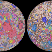
USGS Releases First-Ever Comprehensive Geologic Map of the Moon
FLAGSTAFF, Ariz. – Have you ever wondered what kind of rocks make up those bright and dark splotches on the moon? Well, the USGS has just released a new authoritative map to help explain the 4.5-billion-year-old history of our nearest neighbor in space.
USGS Announces Awards for 2020 Applied Earthquake Research and Monitoring in the U.S.
Agency announces over $20 million in awards for 2020
New USGS map can help Puerto Rico deal with risk of landslides after hurricanes
A new U.S. Geological Survey map of Puerto Rico shows the relative risks of landslides due to the kind of intense rainfall brought on by hurricanes. It identifies 20% of the island as at high risk, 9% at very high risk, and 1% at extremely high risk of landslides under those conditions.


