

The map shows Hurricane Laura moving toward Louisiana and Texas in the Gulf of Mexico.

National Airport
Dulles
BWI
Right Now
77.0 °
(25.0° C)
Weather
Partly Cloudy
Wind
South at 8.1 mph
Dew Point
70.0 F
Pressure
1013.8 mb
Last updated: Aug 27 2020, 7:52 a.m.
73.0 °
(22.8° C)
Weather
Partly Cloudy
Wind
South at 10.4 mph
Dew Point
69.1 F
Pressure
1013.5 mb
Last updated: Aug 27 2020, 7:52 a.m.
76.0 °
(24.4° C)
Weather
A Few Clouds
Wind
Southwest at 5.8 mph
Dew Point
69.1 F
Pressure
1012.7 mb
Last updated: Aug 27 2020, 7:54 a.m.
At a Glance
Thu.
-- /96°
Fri.
76° /94°
Sat.
75° /88°
Sun.
66° /83°
Mon.
63° /81°
Tue.
66° /83°
National Hurricane Center says: Expect “catastrophic storm surge, extreme winds, and flash flooding.”

Remnants of Hurricane Laura bring threat of heavy storms to start weekend.

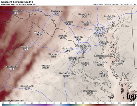
Heat indexes from 100 to 105 degrees are possible tomorrow.
As storms departed, they put on quite a light show on the southern horizon as the fading light from sunset produced a deep, red glow on cloud tops.

Radar courtesy MyRadar | © OpenStreetMap contributors
Saturday or Saturday night may be stormy due to remnants of Hurricane Laura.

The zone from Galveston and Houston through Port Arthur, Tex., to Lake Charles, La., is most at-risk.

Numerous severe thunderstorm warnings were issued Tuesday evening but reports of damage were isolated.

We’ve compiled a list of tropical terms. How many do you already know?

Partly to mostly sunny skies today fuel hot weather, with highs in the low to mid-90s, and afternoon to evening thunderstorms.

Storm will approach Wednesday with winds over 100 mph and a storm surge of 7 to 11 feet.

There's very little to prevent Tropical Storm Laura from rapidly intensifying in the Gulf of Mexico before making landfall on Wednesday night.

There is an enhanced risk of storms turning severe tomorrow.

We haven’t hit 90 degrees in almost two weeks. That’s about to change.

Louisiana could see an unprecedented two storm landfalls in three days: Marco striking Monday and the more formidable Laura late Wednesday into Thursday.

Most of the afternoon storm activity should be north and west of the DC metro area.

Another dry lightning event could spark dozens of new fires, further stretching the state's resources.

The heat builds a bit the next few days with moderate to high humidity.

Intensifying storms could strike the same areas between Monday and midweek.

One blaze is now the second-largest on record in California. The blazes have burned hundreds of homes and forced more than 100,000 evacuations.

Showers will become less of an issue after dark.

There's nothing more than a passing shower or storm risk, at times.

California’s outbreak of lightning-sparked wildfires has charred more than a half-million acres in just one week.

We could be up near 90 by Sunday.

Simultaneous Gulf of Mexico hurricanes, something that's never been observed in tropical weather history, could occur on Monday.
