
Coos Bay Newsroom
Bureau of Land Management offices post News Releases to share news or let you know upcoming plans for their area. If you have questions regarding a specific News Release, contact information is at the top of each News Release. Please feel free to contact the Coos Bay Office with your questions or comments, at 541-756-0100 or by email.
What's the latest with BLM? Keep up with us here: 


| Coos Bay News Releases in 2017 | |
|---|---|
| Oct 17 2016 | BLM Completes Comprehensive Update of Its Oil and Gas Measurement Rules |
Announcements

Cable Crossing Fire Closure Order
Date: 08/07/15
The BLM Roseburg District is issuing a temporary emergency closure of public lands in Douglas County, Oregon. This closure affects public lands within and adjacent to the Cable Crossing fire, on lands administered by the BLM.
This emergency closure is necessary to ensure public safety, land health, and resource integrity during firefighting activities. The fire is not contained or controlled, and ongoing suppression and restoration activities preclude safe public access. The areas affected by this closure order will be posted with appropriate regulation signs at main access and entry points.
- Closure Order News Release (PDF)
- Closure Order Map (PDF)
- Closure Order (PDF)
BLM Releases Draft Plan for Western Oregon
Date: 04/24/15
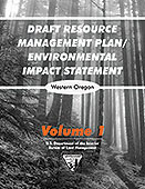
The Bureau of Land Management has released draft alternatives for the future management of 2.5 million acres of BLM-administered lands in western Oregon to better achieve social, economic and ecological objectives. The 90-day public comment period includes 16 open houses or workshops in the region. Five alternatives are detailed in the Draft Resource Management Plan (RMP)/Environmental Impact Statement (EIS) for western Oregon, which is available online at: http://www.blm.gov/or/plans/rmpswesternoregon/meetings.php
For more information, check out our website:
http://www.blm.gov/or/plans/rmpswesternoregon/
Watch videos:
http://www.blm.gov/or/plans/rmpswesternoregon/videos.php
News Release:
http://www.blm.gov/or/news/files/BLM_Oregon_RMP_Draft_DEIS_RMPs_Press_Release.FINAL_.pdf (PDF)
Date: 12/10/14

The BLM has released the next series of its popular vintage poster collection and it includes a poster of the San Juan Islands National Monument (SJINM). The SJINM encompasses about 1,000 acres of land spread across rocks and islands managed by BLM. The vintage-style drawing featured on the poster is of Patos Island and its lighthouse, which is a dominant feature of the area.
Stop by your local BLM Office to free copy of this spectacular poster!
- To learn more about this poster series head on over to: http://tmblr.co/Z9wNeu1XfIBxE
- Flickr photo album dedicated to vintage posters: http://blm.gov/b4ld
- San Juan Poster Press Release
Draft Environmental Impact Statement for the Jordan Cove Energy and Pacific Connector Gas Pipeline Projects
Date: 11/07/14

The Bureau of Land Management and the U.S. Forest Service have announced the Federal Energy Regulatory Commission's release of Draft Environmental Impact Statement for the Jordan Cove Energy and Pacific Connector Gas Pipeline Projects. The Federal Energy Regulatory Commission is the lead Federal agency for this proposed project. The Bureau of Land Management, U.S. Forest Service, and Bureau of Reclamation are cooperating agencies and these agencies' actions are included as part of the Federal Energy Regulatory Commission's analysis. The Bureau of Land Management has authorities under the Natural Gas Act to issue rights-of-way on behalf of itself and other Federal agencies.
- BLM/USFS Press Release (PDF)
- Draft Environmental Impact Statement for the Jordan Cove Energy and Pacific Connector Gas Pipeline Projects
- Comments to the Federal Energy Regulatory Commission
History of the GLO in Oregon
Date: 07/10/2014

BLM is proud to announce the release of this new book that provides an in-depth look at Oregon's history through the eyes of the General Land Office. The General Land Office GLO is an integral piece in the mosaic of Oregon's history. Today the imprint of the GLO on Oregon's landscape is unmistakable in its cardinally-oriented roads and property lines. However, the story of the GLO in Oregon runs deeper than mapping and surveying the lands. As agents of the United States, GLO surveyors operated under the umbrella of United States' public land laws and policies and treaty-making with Indian tribes. This free book is just a small, but fascinating piece of Oregon's history and the role played by the GLO! Download your free copy here (PDF).
Loon Lake Opening for Limited Operations During Summer 2014
Date: 02/11/14
Loon Lake Campground will be open this summer, but for fewer days and with reduced services due to a persistent lack of potable water at the site.
The campground will be open for Memorial Day, Fourth of July and Labor Day weekends, as well as non-holiday weekends (Friday through Sunday) from July 11 to September 28. The day-use area will be open seven days a week from 8 am to 8 pm between Memorial Day weekend and September 30. Visitors can start making reservations to camp during these dates on February 16, 2014.
- Frequently Asked Questions (PDF)
- Summer 2014 Calendar (PDF)
Date: 09/21/12

The Bureau of Land Management (BLM) and the U.S. Forest Service announced that they will consider amendment of their land management plans to make provision for the Pacific Connector Gas Pipeline (PCGP). The Notice of Intent to initiate the public scoping process for this effort was published in the Federal Register on September 21, 2012.
- PCGP press release - September 2012 (PDF)
- PCGP Federal Register Notice of Intent - September 2012 (PDF)
- PCGP Information (PDF)
- Federal Energy Regulatory Commission website

BLM Initiates Planning Update for Western Oregon Forests
Date: 03/09/12
On March 9, 2012, the BLM announced it was beginning the process of revising Resource Management Plans (RMP) for 2.5 million acres of forested lands across six BLM Districts in western Oregon. The BLM is seeking public input on the issues and alternatives the new RMPs should address.
BLM State Director Ed Shepard stated: "The BLM welcomes new and innovative ideas that result from this scoping process. The planning process will recognize the importance of the social, cultural, and economic dimensions of natural resource management in western Oregon. Integrating public values and perspectives into the planning process is critical to finding a sustainable path forward."

Secretary Salazar Proposes Expansion of Ecological Forestry in Western Oregon and Update Resource Management Plans
Date: 02/22/12
During a visit on February 21 to one of three ecological forestry pilot projects in Oregon, Secretary of the Interior Ken Salazar announced that the Department of the Interior's Bureau of Land Management (BLM) will apply ecological forestry principles on a broader landscape to restore forest health and to provide sustainable timber harvests for local mills and the communities who rely on the timber industry for jobs and economic strengths.

Forestry Pilot Projects Report
Date: 02/14/12
Following up on the December 8, 2010 meeting in Washington, D.C. the BLM committed to immediately develop action plans for both the Roseburg Pilot Project and the Middle Applegate Watershed Pilot Project. Throughout 2011, the BLM, along with Drs. Norm Johnson and Jerry Franklin, held a series of public meetings, workshops, and field trips to discuss the pilot projects and learn more about the principles of ecological forestry. In February 2012, the BLM released a report regarding the Drs. Johnson and Franklin's observations about the Forestry Pilot Projects.
- Pilot Project Report (February 2012) (PDF)
- Press Release (PDF)

BLM Distributes Final Payments to Counties
Date: 01/20/12
The BLM announced today that it has issued payment to 18 counties in western Oregon eligible under the Secure Rural Schools and Community Self-Determination Act extension (Public Law 110-343). The amount paid to the Oregon & California (O&C) counties was $40,037,160.
- Official 2011 Payment to the Counties (PDF)
- Press Release: BLM Distributes Final Payments to Counties (PDF)
- County Payments Background
Date: 09/21/11
Interior Conservation Awards to BLM-Led Partnerships
Secretary of the Interior Ken Salazar presented his "Partners in Conservation" Awards to a number of outstanding conservation partnerships at a ceremony on September 21, 2011. The awardees included four BLM-coordinated partnerships: Oregon's Jefferson Conservation Corps; the Gila Watershed Partnership of Arizona; New Mexico's Permian Basin Memorandum of Agreement Program; and the nationwide Project Archaeology program.
A video profile about the Jefferson Conservation Corps is available on YouTube at:
In addition, an article about the Jefferson Conservation Corps is available in winter 2010 issue of BLM's magazine, NW Passage:
Date: 08/23/11

Socioeconomic Impacts of the BLM
The BLM has the privilege of protecting and maintaining some of the Nation's most unique treasures. We manage over 15.7 million acres of public land in Oregon, and approximately 436,000 acres in Washington, together with some 23.4 million acres of federal subsurface minerals. The BLM lands provide for a variety of multiple uses throughout the Northwest, all of which contribute to the well-being of local communities through economic activities, social contributions, and land stewardship programs. Take a look around at these socio-economic contributions; we think you'll be pleasantly surprised.
- Contributing to Oregon's Economy (PDF)
- BLM - A Sound Investment for America (PDF)
- DOI's Economic Contributions (PDF)
- BLM and the Economy Op-Ed (PDF)

BLM Releases 2011 Secure Rural Schools Estimates
Date: 08/05/11
The Secure Rural Schools and Community Self-Determination Act (Public Law 110-343) provided transition payments to the 18 western Oregon O&C counties through Fiscal Year 2010 and established another formula for calculating O&C county payments for Fiscal Year 2011. In developing the estimate for the Fiscal Year 2011 payment under the other formula, the BLM found an error in its preliminary calculations. The correct estimate was published in the President's Fiscal Year 2012 Budget Justifications submitted to the Congress in March 2011. Because of the nature of the variables for calculating payments as established in the Secure Rural Schools Act, the final amount of O&C county payments for Fiscal Year 2011 cannot be determined until the end of Fiscal Year 2011—after September 30, 2011. The final payment amount is subject to review and audit before the payments are made to counties 6 to 8 weeks following the close of the Fiscal Year 2011.
- FY 2012 Payment Estimate to be Paid in 2011 (PDF)
- Secure Rural Schools Letter to the Oregon Congressional Delegation (PDF)
- President's FY 2012 Budget Justifications (Chapter 7, Page 13) (PDF)
BLM, Oregon State Parks Seek Comments on Bastendorff Beach Plan

Date: 02/28/11
Bastendorff Beach is one of the most popular beaches in the Coos Bay area. The BLM and Oregon State Parks are increasingly hearing concerns from the local community about sanitation and safety at the site. To help address some of these concerns, the agencies developed a draft plan to guide future management of the site, and are now taking comments until March 15, 2011. Please email your comments to or_coosbay_mail@blm.gov.
- Draft Bastendorff Beach Cooperative Management Plan (PDF)
- Public Ownership Map (PDF)
- Public Scoping Comments (PDF)

BLM Restores Guidance for Managing Lands with Wilderness Characteristics
Date: 02/25/11
The Bureau of Land Management (BLM) today issued guidance to its field managers describing how the agency will use its land use planning process to enable local communities, States, Tribes, the public, and stakeholders to help determine how to manage public lands with wilderness characteristics.
The guidance will ensure public lands with wilderness characteristics are inventoried, described, and managed in accordance with Secretarial Order 3310, issued by Interior Secretary Ken Salazar in December.

President Proposes $1.13 Billion for BLM in Fiscal Year 2012 To Protect Resources and Manage Uses of Public Lands
Date: 02/14/11
President Obama today requested $1.13 billion in appropriations for the Interior Department's Bureau of Land Management in Fiscal Year (FY) 2012, a decrease of $12.0 million from the 2010 Enacted/2011 Continuing Resolution level. The budget makes strategic investments in support of Administration and Secretarial initiatives, and offsets funding increases for these priorities with $25.5 million in administrative and management savings, shifting $42.4 million in energy and minerals inspection costs to industry, and reducing lower-priority programs.
Under the President's proposed budget, the BLM will focus on a number of priorities, including: Renewable Energy; Cooperative Landscape Conservation, including Sage-grouse Habitat Management; Youth in the Great Outdoors; Abandoned Mine Lands and Hard Rock Mining Reform; Wild Horse and Burro Program; and the Secretary's Western Oregon Strategy.
- Department of the Interior 2012 Budget Press Release (PDF)
- BLM 2012 Budget Press Release (PDF)
- The BLM: A Sound Investment for America (PDF)

BLM Releases Decision for Vegetation Treatments
Date: 10/01/10
On October 1, 2010, the Bureau of Land Management (BLM) Oregon State Office announced the release of a Record of Decision for the Vegetation Treatments Using Herbicides on BLM Lands in Oregon. Weeds are currently spreading on BLM lands in Oregon at an estimated 12 percent per year, or 144,000 acres per year. This decision expands herbicide use beyond noxious weed treatments to include: the treatment of all invasive plants, the control of pests and diseases, and the control of native vegetation in rights-of-way and administrative sites, and recreation sites.
- Vegetation Treatments Press Release (PDF)
- Vegetation Treatments Fact Sheet (PDF)
- Final EIS and Record of Decision
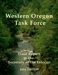
BLM Releases Western Oregon Forest Management Report
Date: 07/22/10
Bureau of Land Management (BLM) Director Bob Abbey today announced the findings of the interdisciplinary Western Oregon Task Force and an interagency approach for moving forward in the management of BLM-managed forests in western Oregon.
President Proposes $1.1 Billion for BLM in Fiscal Year 2011

Date: 02/01/10
With a focus on renewable energy development, climate change adaptation, and other key priorities, President Obama today requested $1.1 billion in appropriations for the Department of the Interior's Bureau of Land Management in Fiscal Year 2011. This represents an $8.0 million increase from the BLM's FY 2010 enacted funding level. The President's request reflects his continuing commitment to be prudent with taxpayer dollars while setting priorities for spending.
BLM Distributes Payments to Counties
Date: 11/25/09

The Secure Rural Schools and Community Self-Determination Act was reauthorized as part of the Emergency Economic Stabilization Act of 2008 signed into law in October 2008 (Public Law 110-343). The reauthorized act provides declining payments to 18 westside Oregon Counties from Fiscal Year 2008 through 2011. Eligible counties in Oregon and several other �transition� States will receive declining payments from Fiscal Years 2008 to 2010 based upon their Fiscal Year 2006 payments. Then, in Fiscal Year 2011, counties will receive payments based on a new formula detailed in the Emergency Economic Stabilization Act of 2008. The Act included other changes, such as limiting how counties may spend their Title III project funds. The Oregon/Washington BLM made payments to each of the eligible western Oregon counties for Fiscal Year 2009 on November 25, 2009.
- News Release (PDF)
- Official 2009 Payments (PDF)
Secretary Salazar to Discuss Next Steps for Western Oregon Forest Management
Date: 10/14/09

On Wednesday, October 14, 2009, Secretary of the Interior Ken Salazar hosted a news media teleconference to discuss a schedule of timber sales on public lands in Western Oregon and initial steps for forest management in the area.
To provide additional certainty to local mills and local communities, the BLM released a list of about 60 proposed timber sales scheduled over the next 12 months. The program of work reflects an interim approach as the U.S. Fish and Wildlife continues to work on refinement of the northern spotted owl recovery plan via a number of technical workgroups.
- Western Oregon 2010 Program of Work
- Department of the Interior Launches Work Plan for BLM Western Oregon Forests
BLM Prepares for Upcoming Oil and Gas Lease Sale
Date: 3/4/09

The Bureau of Land Management (BLM) Oregon State Office has announced that it will offer four parcels totaling approximately 5,342 acres, in Oregon, at its March 12, 2009 Oil and Gas Lease Competitive Sale. All four parcels to be offered are in Wheeler County near Mitchell, Oregon. The sale will be held at 9:00 AM, Thursday, March 12, at the Robert Duncan Plaza Building, 333 SW 1st Avenue, Portland, Oregon in the 3rd floor conference rooms.
Mystery Shipwreck Identified
The wooden hulled ship buried in sand on the North Spit of Coos Bay has been identified by archeologists as the George L. Olson.
Research suggests there is strong evidence that the mystery shipwreck is the bow-section of the steam schooner George L. Olson. Comparing historical photographs of the George L. Olson with current pictures of the shipwreck, both ships have three portholes with three chain plates aft of the portholes. The location of the Samson Post, Hawespipes, and the black vertical bumpers are identical. The pattern made by the through hull iron fasteners also appears identical (see attached photograph).
The story of the George L. Olson is outlined below:
The George L. Olson was originally named the Ryder Hanify. The steam schooner Ryder Hanify was built for J.R. Hanify and Company of San Francisco by the W.F. Stone shipyards of Oakland, California. The ship was launched on January 22, 1917. At 223 feet long and nearly 44 feet wide, the Ryder Hanify was one of the largest ships built to date at the Stone shipyard. The boat was powered by a 1,000 horse power steam engine and was designed to carry 1.4 million board feet of lumber at a time. read more>>
The Ryder Hanify was put into service in May 1917 hauling lumber. It completed several voyages during that year, including a shipment of lumber to South America in October, 1917.
On December 6, 1917, the Ryder Hanify, along with six other lumber carrying ships, was sold to the French government. The French government renamed the Ryder Hanify the Gabriel.
On March 9, 1922 an announcement was made in the Los Angeles Times that Oliver J. Olson , a �prominent lumber and steamship owner� had purchased two steam schooners from the French government and was now refitting them for the lumber trade. This included the Gabriel, which Olson renamed the George L. Olson.
The George L. Olson worked as a lumber carrying schooner in the Northwest for over 20 years until June 23, 1944 when it struck Coos Bay's North Jetty and drifted aground on Guano Rock inside the Coos Bay channel. There were no casualties when the ship wrecked, but the ship was declared a total loss. At the time it wrecked, the George L. Olson was loaded with about 1.4 million board feet of lumber.
Salvage of the ship's lumber cargo was conducted for the next six months. Five hundred thousand board feet of lumber recovered off of the ship was used to construct the Baptist Church in Charleston.
In December 1944, the hulk of the George L. Olson was towed to sea and was cut adrift with the intention she beach on the North Spit. During the following years, build-up of the foredune in the area covered the wreck.
The BLM, along with State of Oregon Oregon Parks and Recreation Department, the Coos County Historical and Maritime Museum, and NOAA, continue to consult with the Oregon State Historic Preservation Office to review options and make plans for the ship's future. BLM and Museum staff continue to document the ship with photographs.
For additional information feel free to contact:
- Megan Harper � BLM - 541-751-4353
- Steve Samuels � BLM - 541-751-4244
- Anne Donnelly � Coos County Historical and Maritime Museum � 541-756-6320
- Calum Stevenson � Oregon Parks and Recreation Department � 541-888-9324
- Robert Schwemmer � NOAA Office of National Marine Sanctuaries in Santa Barbara � 805-884-1466
Related Documents:
Original George L. Olson Photos

Ryder_Hanify_Bow � Bow section of the Ryder Hanify (George L. Olson) taken June 3, 1917 in San Pedro, CA on one its first voyages. Photo courtesy of Robert Schwemmer at the Office of National Marine Sanctuaries. |

Full ship � The Ryder Hanify taking the water. Photo courtesy of Robert Schwemmer at the Office of National Marine Sanctuaries. |
Present Day George L. Olson Photos

|

|

|

|

|
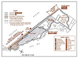
View a detailed shipwreck location map along the Coos Bay coast. |
Want to learn more about RMPs for Western Oregon?